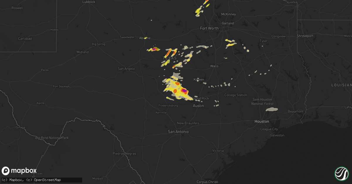
Hail Map on May 5, 2023
Get this storm
May 5 map
$229
one time, instant access
Download today. No call, no setup
Keep the $229
Bought the map and want the full workflow? Apply the entire $229 to a subscription within 7 days. None of it is wasted.
Every map, not just this one
This buys you this map. Subscription and you get every map we run, in the markets you choose from a few cities to whole states to nationwide. Plus real-time alerts the moment a storm fires.
Contact data
Name, contact info, occupancy, even credit band for addresses in the footprint. You go from where it hit to who to call.
Become the source they trust
Unlimited branding weather history reports on demand. You already have the documented answer ready for the property owner, and you are the one who showed up with it.
Property data and RoofTrace estimates
Pull up any address you have got, its value and the exact code rules for that jurisdiction, straight from One Click Code. Then RoofTrace estimates the squares, pitch, and roof value, priced the way you price.
States Impacted by Hail Map on May 5, 2023
Storm reports
Wyoming
| Date | Description |
|---|---|
| 05/05/202312:20 PM CDT | Landspout. Public recorded video of landspout tornado from county road 283 facing west in robertson... Wy. Approximate location of the landspout tornado is near the int |
Louisiana
| Date | Description |
|---|---|
| 05/05/20236:01 AM CDT | Powerline down across the road. |
| 05/05/20236:01 AM CDT | Powerline down. |
| 05/05/20235:57 AM CDT | *** 1 inj *** the tornado started near lyons point hwy and kite rd before continuing southeast rapidly. Roughly 8 outbuildings were destroyed along a subdivision on sal |
| 05/05/20235:57 AM CDT | Reported severe home damage. Possible tornado damage. |
Texas
| Date | Description |
|---|---|
| 05/05/20236:58 PM CDT | Egg size hail reported on hwy 29 near the brandenburg plumbing business to the east of burnet. |
| 05/05/20236:56 PM CDT | A local report indicates 2.00 inch wind near 3 ESE BURNET |
| 05/05/20236:56 PM CDT | Report from mping ping pong ball |
| 05/05/20236:50 PM CDT | Report from mping quarter |
| 05/05/20236:44 PM CDT | A local report indicates 1.75 inch wind near BURNET |
| 05/05/20236:35 PM CDT | Cracked windshield on vehicle. |
| 05/05/20236:32 PM CDT | Video of ping pong size hail near the intersection of hwy 29 and rr 2341. Time estimated via radar. |
| 05/05/20236:19 PM CDT | A local report indicates 1.00 inch wind near 5 NNE INKS LAKE STATE P |
| 05/05/20235:34 PM CDT | Report from mping. |
| 05/05/20235:32 PM CDT | Report from mping: golf ball |
| 05/05/20235:26 PM CDT | Report from mping: ping pong ball |
| 05/05/20235:17 PM CDT | Report from mping: golf ball |
| 05/05/20235:03 PM CDT | A local report indicates 1.25 inch wind near 4 SSW HARKEYVILLE |
| 05/05/20235:02 PM CDT | Pea to quarter sized hail falling at the state park. |
| 05/05/20234:40 PM CDT | A local report indicates 1.25 inch wind near 9 WNW VALLEY VIEW |
| 05/05/20234:40 PM CDT | A local report indicates 1.25 inch wind near ALVORD |
| 05/05/20234:32 PM CDT | 4 inch tree limbs down along fm 1655. |
| 05/05/20234:30 PM CDT | 4 inch tree limbs down along fm 1450. |
| 05/05/20234:26 PM CDT | A local report indicates 1.00 inch wind near 4 SSE EARLY |
| 05/05/20234:15 PM CDT | A local report indicates 2.00 inch wind near 9 ESE OPLIN |
| 05/05/20234:15 PM CDT | A local report indicates 1.00 inch wind near 1 N BRIDGEPORT |
| 05/04/202311:53 PM CDT | Delayed report: kact asos reported 50 knot wind gust. |
| 05/04/202311:32 PM CDT | Nearly 1800 customers reported without power due to thunderstorms in robertson and brazos counties. |
| 05/04/202311:30 PM CDT | Weatherstem station at kyle field. |
| 05/04/202311:20 PM CDT | Social media picture of metal roofing blown off of a barn near the intersection of thurman rd and old cameron ranch road north of bryan. Time estimated by radar. |
| 05/04/202310:47 PM CDT | Estimated winds of 50 to 60 mph at fm 1460 and westinghouse rd. |
| 05/04/202310:25 PM CDT | A local report indicates 1.00 inch wind near 3 E ENCHANTED ROCK STAT |
| 05/04/202310:18 PM CDT | Report from mping quarter. |
| 05/04/202310:16 PM CDT | T35 |
| 05/04/202310:10 PM CDT | A local report indicates 1.00 inch wind near 1 NNW LAGO VISTA |
| 05/04/202310:02 PM CDT | 64 mph measured at aprswxnet/cwop station fw7040 in lago vista. |
| 05/04/20239:25 PM CDT | Mostly dime and nickel size with quarter size mixed in. |
| 05/04/20239:11 PM CDT | Report from mping half dollar. |
| 05/04/20239:02 PM CDT | A local report indicates 1.00 inch wind near 2 W BERTRAM |
| 05/04/20238:59 PM CDT | Report from mping quarter. |
| 05/04/20238:56 PM CDT | Report from mping quarter. |
| 05/04/20238:56 PM CDT | Downed trees near the intersection of fm 1431 and phillips ranch rd; 1100 people without power in granite shoals. Time estimated via radar. |
| 05/04/20238:56 PM CDT | Report from mping 3-inch tree limbs broken... Power poles broken. |
| 05/04/20238:55 PM CDT | Reports of down power pole and several transformers out near sunrise beach. Time estimated via radar. |
| 05/04/20238:50 PM CDT | Trees and power poles down from sandy mountain to sunrise beach. Time estimated via radar. |
| 05/04/20238:45 PM CDT | Report from mping quarter. |
| 05/04/20238:42 PM CDT | Reports of down power pole and several transformers out near kingsland. Time estimated via radar. |
| 05/04/20238:25 PM CDT | A local report indicates 1.25 inch wind near 1 E LLANO |
| 05/04/20238:15 PM CDT | A local report indicates 68 MPH wind near 3 NNE LLANO |
| 05/04/20238:07 PM CDT | A local report indicates 1.00 inch wind near LLANO |
| 05/04/20237:30 PM CDT | Time estimated via radar. |
| 05/04/20237:10 PM CDT | A local report indicates 1.00 inch wind near 3 N HICO |
| 05/04/20237:10 PM CDT | Intersection of fm 690 and peninsula drive. Time estimated. |
| 05/04/20237:05 PM CDT | Social media picture of hail measured up to near tennis ball size near the burnet municipal airport with rough time estimate of 7:05 pm. |
Colorado
| Date | Description |
|---|---|
| 05/04/20237:53 PM CDT | A local report indicates 75 MPH wind near 5 WSW PLEASANT VALLEY |
| 05/04/20237:39 PM CDT | Spotter reported outflow winds from thunderstorm to the north. Measured sustained winds at 63 mph with gusts to 70 mph. |
| 05/04/20237:36 PM CDT | Mesonet station co048 us 385 holyoke. |
Nebraska
| Date | Description |
|---|---|
| 05/05/20236:59 PM CDT | A local report indicates 59 MPH wind near 3 SE ALLIANCE |
| 05/05/20236:53 PM CDT | A local report indicates 1.00 inch wind near RIVERTON |
| 05/05/20236:30 PM CDT | Report via nerain. Time est from radar. |
| 05/05/20236:14 PM CDT | Ongoing on the north side of franklin. |
| 05/05/20236:12 PM CDT | Hail up to half dollar size reported by county dispatch. |
| 05/05/20236:04 PM CDT | A local report indicates 1.75 inch wind near 1 N BLOOMINGTON |
| 05/05/20235:55 PM CDT | It hailed for at least 30 mins starting around 530 pm but was mostly up to nickel size. Largest hail up to golf ball started around 555 and lasted 10 mins. |
| 05/05/20235:47 PM CDT | Via mping. |
| 05/05/20235:25 PM CDT | A local report indicates 1.00 inch wind near 3 E ALMA |
| 05/05/20235:22 PM CDT | A local report indicates 1.25 inch wind near REPUBLICAN CITY |
| 05/05/20235:15 PM CDT | Report from facebook of quarter size hail at hunter cover at harlan county lake. |
| 05/05/20235:00 PM CDT | Reports via facebook of nickel to quarter size hail in alma. Time estimated from radar. |
| 05/05/202312:28 AM CDT | A local report indicates 1.00 inch wind near 3 N KEARNEY |
| 05/05/202312:25 AM CDT | Damage report via email included the following... A tree limb 8 inches in diameter was downed... A metal deck chair was blown around 20 ft from its original location... |
| 05/05/202312:21 AM CDT | A local report indicates 73 MPH wind near 6 NNE SHERMAN RESERVOIR |
| 05/05/202312:12 AM CDT | A local report indicates 58 MPH wind near 1 N SHERMAN RESERVOIR |
| 05/05/202312:11 AM CDT | Home weather station. |
| 05/05/202312:11 AM CDT | Home weather station |
| 05/05/202312:08 AM CDT | Report of quarter size h |
| 05/05/202312:08 AM CDT | Report of quarter size hail relayed by the emergency manager. |
| 05/05/202312:08 AM CDT | Report of quarter size hail relayed via emergency manager. |
| 05/05/202312:06 AM CDT | Collapsible flag pole taken down... Em guesses 45-50 mph wind. |
| 05/04/202311:37 PM CDT | A local report indicates 63 MPH wind near 8 S ELM CREEK |
| 05/04/202311:24 PM CDT | A local report indicates 59 MPH wind near BROKEN BOW |
| 05/04/202311:24 PM CDT | A local report indicates 62 MPH wind near 4 NNW SUMNER |
| 05/04/202311:15 PM CDT | A local report indicates 61 MPH wind near LEXINGTON AIRPORT |
| 05/04/202311:10 PM CDT | Public report of lost power at johnson lake. Tree branch of unknown size was downed. A couple of docks were flipped. Time estimated based on radar. |
| 05/04/202311:10 PM CDT | Public report via twitter of power lost at johnson lake... A tree branch of unknown size was downed... And a couple docks flipped. Time estimated based on radar. |
| 05/04/202311:09 PM CDT | A local report indicates 70 MPH wind near BROKEN BOW |
| 05/04/202310:56 PM CDT | Facebook photos... Garage door blown in... Fence blown down... Shed collapsed. |
| 05/04/202310:56 PM CDT | A local report indicates 58 MPH wind near 3 S JOHNSON LAKE |
| 05/04/202310:23 PM CDT | A local report indicates 1.25 inch wind near 1 ESE KEARNEY |
| 05/04/202310:20 PM CDT | A local report indicates 60 MPH wind near CURTIS |
| 05/04/202310:19 PM CDT | A local report indicates 1.00 inch wind near 1 ESE KEARNEY |
| 05/04/202310:14 PM CDT | From spotter network. |
| 05/04/202310:12 PM CDT | Report from mping: quarter |
| 05/04/202310:04 PM CDT | Video of quarter size hail south of kearney from twitter. Exact location estimated from radar. |
| 05/04/202310:00 PM CDT | Mesonet 3 n of hayes center reports 60 mph wind gust. |
| 05/04/20239:15 PM CDT | Spotter drove through hayes center and noticed golf ball sized hail along the roadway. |
| 05/04/20239:04 PM CDT | Personal weather station reports wind gust of 70 mph. |
| 05/04/20239:00 PM CDT | Mesonet 3n of hayes center reports 84 mph wind gust. |
| 05/04/20238:44 PM CDT | Personal weather station report of 62 mph wind gust 1 nnw of sutherland. |
| 05/04/20238:44 PM CDT | Corrects previous hail report of 1.75 inches from cozad. |
| 05/04/20238:35 PM CDT | Imperial asos report of 60 mph gust. |
| 05/04/20238:10 PM CDT | Hail up to size of golf balls started around 810 pm...lasted about 20 mins. |
| 05/04/20238:02 PM CDT | Public report of mostly pea sized hail with some quarter sized hail mixed in. |
| 05/04/20238:00 PM CDT | Personal weather station report of 74 mph wind gust 2 s of lamar. |
| 05/04/20237:56 PM CDT | Spotter network report of ping pong sized hail 4 miles n of enders. |
| 05/04/20237:55 PM CDT | Trained spotter report of golf ball sized hail in between imperial and enders on hwy 6. |
| 05/04/20237:52 PM CDT | Delayed report of hail a little larger than golf ball size. Time estimated from radar. |
| 05/04/20237:40 PM CDT | A local report indicates 1.75 inch wind near 6 NNE ARAPAHOE |
| 05/04/20237:40 PM CDT | Pea to half dollar size hail was reported about 1e of huntley. |
| 05/04/20237:15 PM CDT | Imperial asos reports wind gust of 63 mph. |
| 05/04/20237:07 PM CDT | Quarter to golf ball size hail reported 13ne of cambridge. |
Mississippi
| Date | Description |
|---|---|
| 05/05/20234:17 PM CDT | Emergency management reported structural damage to a luxury inn outside hattiesburg. |
| 05/05/20233:52 PM CDT | Tree reported down blocking the highway on ms highway 13 at landrum cemetery road in pearl river county. Time estimated by radar. |
| 05/05/20233:41 PM CDT | Emergency management reported multiple trees down across covington county. A tree fell on a car due to the strong thunderstorm winds... However no injuries were reporte |
| 05/05/20233:36 PM CDT | Pictures from social media via twitter show a tree down on a home near king rd in hattiesburg. |
| 05/05/20233:36 PM CDT | Emergency management reported multiple trees down all across forrest county. |
| 05/05/20233:23 PM CDT | Trees down on epley rd. |
| 05/05/20233:22 PM CDT | Reports of multiple trees down near mitchell hudson rd. |
| 05/05/20233:19 PM CDT | Emergency management reported numerous trees and powerlines down near partman cemetery in nw jefferson davis county. |
| 05/05/20233:15 PM CDT | Multiple trees down. |
| 05/05/20233:06 PM CDT | Emergency management reported structural damage to a house near ridge rd along with several trees down. |
| 05/05/20233:03 PM CDT | Emergency management reported minor structural damage to a house along with several trees down near blackjack rd. |
| 05/05/20233:00 PM CDT | Tree down in town... 3 homes damaged from this tree. |
| 05/05/20232:59 PM CDT | Photographs show ground covering hail in sumrall. The majority of the hail was small... But some stones reached one inch in diameter. |
| 05/05/20232:59 PM CDT | Tree down at n bryant and rocky branch rd. |
| 05/05/20232:59 PM CDT | Trees down across hwy 589. |
| 05/05/20232:20 PM CDT | Multiple trees down across the nw part of the county. |
| 05/05/20232:17 PM CDT | Trees down. |
| 05/05/20232:15 PM CDT | A local report indicates 1.00 inch wind near NEW HEBRON |
| 05/05/20232:15 PM CDT | Trees down and damage to a cafeteria... More damage exists... But details to come later. |
| 05/05/20232:13 PM CDT | Reports of several trees down near nelson rd. |
| 05/05/20232:13 PM CDT | Trees down on hwy 42 and 43. |
| 05/05/20231:54 PM CDT | Reports of several trees and powerlines down near jackson ave right outside georgetown. |
| 05/05/20231:51 PM CDT | Reports of multiple trees down near hwy 51. |
| 05/05/20231:51 PM CDT | Multiple trees down near poplar springs rd. |
| 05/05/20231:48 PM CDT | Public reports of a few trees and powerlines down near great southern rd. |
| 05/05/20231:48 PM CDT | Public reports of multiple trees down near hwy 51 near south wesson. |
| 05/05/20231:45 PM CDT | Reports of multiple trees down near steel creek rd. |
| 05/05/20231:45 PM CDT | Reports of multiple trees and powerlines down near rockport rd. |
| 05/05/20231:45 PM CDT | Tree down across poplar springs rd. |
| 05/05/20231:41 PM CDT | Reports of multiple trees down near shreby lane north of hwy 28. |
| 05/05/20231:40 PM CDT | Public reports several trees along with a few powerlines down near jackson st... A few miles north of hwy 28. |
| 05/05/20231:31 PM CDT | Reports of a few trees down near may ln. |
| 05/05/20231:31 PM CDT | Reports of multiple trees down near lilly rd. |
| 05/05/20231:31 PM CDT | Tree down on house on cola lane. Trees down across i-55 in hazlehurst. |
| 05/05/20231:22 PM CDT | Several trees down near/in the gallman area. |
| 05/05/202312:52 PM CDT | Several trees down near raymond rd. |
Cities Impacted by Hail Map on May 5, 2023
- Lake City, MN
- Pinola, MS
- Newhebron, MS
- Mendenhall, MS
- Prentiss, MS
- Mount Olive, MS
- Bassfield, MS
- Carson, MS
- Collins, MS
- Sumrall, MS
- Seminary, MS
- Hattiesburg, MS
- Coleman, TX
- Clyde, TX
- Abilene, TX
- Burkett, TX
- Cross Plains, TX
- Baird, TX
- Brookesmith, TX
- Brownwood, TX
- Bridgeport, TX
- Paradise, TX
- Chico, TX
- Alvord, TX
- Early, TX
- Zephyr, TX
- Blanket, TX
- San Saba, TX
- Cherokee, TX
- Hay Springs, NE
- Forestburg, TX
- May, TX
- Comanche, TX
- Decatur, TX
- Era, TX
- Gainesville, TX
- Rosston, TX
- Muenster, TX
- Sidney, TX
- Alma, NE
- Republican City, NE
- Naponee, NE
- De Leon, TX
- Mullin, TX
- Goldthwaite, TX
- Bloomington, NE
- Franklin, NE
- Tow, TX
- Lampasas, TX
- Riverton, NE
- Harrison, NE
- Georgetown, MS
- Bush, LA
- Poplarville, MS
- Picayune, MS
- Carriere, MS
- Petal, MS
- New Augusta, MS
- Lusk, WY
- Morrill, NE
- Lyman, NE
- Minatare, NE
- Bayard, NE
- Hazlehurst, MS
- Silver Creek, MS
- Crystal Springs, MS
- Harrisville, MS
- Magee, MS
- Stamford, NE
- Oxford, NE
- Orleans, NE
- Burnet, TX
- Bluffton, TX
- Hamilton, TX
- Inavale, NE
- Bertram, TX
- Art, TX
- Mason, TX
- Castell, TX
- Valley Spring, TX
- Red Cloud, NE
- Eustis, NE
- Cambridge, NE
- Holbrook, NE
- Julesburg, CO
- Amherst, CO
- Venango, NE
- Wray, CO
- Haigler, NE
- Parks, NE
- Benkelman, NE
- Imperial, NE
- Champion, NE
- Llano, TX
- Arapahoe, NE
- Elwood, NE
- Grant, NE
- Enders, NE
- Edison, NE
- Bertrand, NE
- Wauneta, NE
- Marble Falls, TX
- Wilcox, NE
- Hayes Center, NE
- Cozad, NE
- Hildreth, NE
- Loomis, NE
- Buchanan Dam, TX
- Holdrege, NE
- Kingsland, TX
- Lexington, NE
- Maywood, NE
- Paoli, CO
- Holyoke, CO
- Haxtun, CO
- Sutherland, NE
- Paxton, NE
- Elsie, NE
- North Platte, NE
- Wallace, NE
- Hershey, NE
- Palisade, NE
- Funk, NE
- Axtell, NE
- Palmer, TX
- Ennis, TX
- Corsicana, TX
- Rice, TX
- Chatfield, TX
- Maxwell, NE
- Minden, NE
- Kearney, NE
- Fredericksburg, TX
- Round Mountain, TX
- Spicewood, TX
- Leander, TX
- Waxahachie, TX
- Wellfleet, NE
- Crookston, NE
- Farnam, NE
- Hico, TX
- Stephenville, TX
- Dickens, NE
- Angora, NE
- Rushville, NE
- Oshkosh, NE
- Ogallala, NE
- Madrid, NE
- Ovid, CO
- Lisco, NE
- Edgemont, SD
- Moorefield, NE
- Meridian, TX
- Morgan, TX
- Walnut Springs, TX
- Iredell, TX
- Rising Star, TX
- Carlton, TX
- Evant, TX
- Pottsville, TX
- Stockville, NE
- Priddy, TX
- Blum, TX
- Kopperl, TX
- Dublin, TX
- Lebanon, KS
- Lometa, TX
- Broadwater, NE
- Bridgeport, NE
- Rio Vista, TX
- Cleburne, TX
- Glen Rose, TX
- Gustine, TX
- Perkinston, MS
- Sunset, TX
- Brady, NE
- Killeen, TX
- Pearl River, LA
- Horseshoe Bay, TX
- Pontotoc, TX
- Bangs, TX
- Abita Springs, LA
- Covington, TX
- Fort Hood, TX
- Hubbard, TX
- Coolidge, TX
- Salado, TX
- Belton, TX
- Bartley, NE
- Rochelle, TX
- Overton, NE
- Curtis, NE
- Smithfield, NE
- Elm Creek, NE
- Eddyville, NE
- Sumner, NE
- Loup City, NE
- Calvert, TX
- Platte Center, NE
- Primrose, NE
- Mason City, NE
- Blooming Grove, TX
- Barry, TX
- Litchfield, NE
- Bend, TX
- Pleasanton, NE
- Paige, TX
- Amherst, NE
- Cairo, NE
- Newman Grove, NE
- Monroe, NE
- Gibbon, NE
- Palmer, NE
- Belgrade, NE
- Fullerton, NE
- Malakoff, TX
- Saint Paul, NE
- Saint Libory, NE
- Farwell, NE
- Boelus, NE
- Dannebrog, NE
- Ashton, NE
- Elba, NE
- Rockville, NE
- Archer, NE
- Chapman, NE
- Wolbach, NE
- Cedar Rapids, NE
- Pilger, NE
- Wisner, NE
- Bullard, TX
- Flint, TX
- West Point, NE
- Dodge, NE
- Willow City, TX
- Cedar Park, TX
- Austin, TX
- Pflugerville, TX
- Manor, TX
- Saint Edward, NE
- McCook, NE
- Howells, NE
- Clarkson, NE
- Kennard, TX
- Gothenburg, NE
- Hearne, TX
- Franklin, TX
- Genoa, NE
- Lindsay, NE
- Tennessee Colony, TX
- Montalba, TX
- Athens, TX
- Goldsboro, TX
- Creston, NE
- Columbus, NE
- Leigh, NE
- Kemp, TX
- Silver Creek, NE
- Crockett, TX
- Central City, NE
- Rogers, TX
- Lexington, TX
- Odessa, NE
- Shelton, NE
- Cameron, TX
- Alto, TX
- Miller, NE
- Centerville, TX
- Bryan, TX
- Buckholts, TX
- Grand Island, NE
- Holland, TX
- Lincoln, TX
- Giddings, TX
- Mabank, TX
- Bancroft, NE
- Pender, NE
- Oconto, NE
- Essex, IA
- Red Oak, IA
- Sidney, IA
- Tabor, IA
- Winnebago, NE
- Liberty, TX
- Dayton, TX
- New Caney, TX
- Huffman, TX
- Cleveland, TX
- Porter, TX
- Humphrey, NE
- Callaway, NE
- Imogene, IA
- Randolph, IA
- Beemer, NE
- Emerson, IA
- Shenandoah, IA
- Farragut, IA