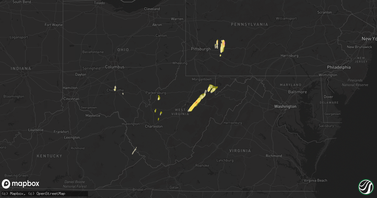
Hail Map in West Virginia on May 4, 2025
Get this storm
May 4 map
$229
one time, instant access
Download today. No call, no setup
Keep the $229
Bought the map and want the full workflow? Apply the entire $229 to a subscription within 7 days. None of it is wasted.
Every map, not just this one
This buys you this map. Subscription and you get every map we run, in the markets you choose from a few cities to whole states to nationwide. Plus real-time alerts the moment a storm fires.
Contact data
Name, contact info, occupancy, even credit band for addresses in the footprint. You go from where it hit to who to call.
Become the source they trust
Unlimited branding weather history reports on demand. You already have the documented answer ready for the property owner, and you are the one who showed up with it.
Property data and RoofTrace estimates
Pull up any address you have got, its value and the exact code rules for that jurisdiction, straight from One Click Code. Then RoofTrace estimates the squares, pitch, and roof value, priced the way you price.
Storm reports in West Virginia
West Virginia
| Date | Description |
|---|---|
| 05/04/20256:36 PM CDT | 2 inches in diameter hail stones reported at kesling mills... Buckhannon. |
| 05/04/20256:30 PM CDT | Photo provided. |
| 05/04/20256:27 PM CDT | Golf ball size hail covering the ground between mm 18.5 us 33 hwy w. |
| 05/04/20256:18 PM CDT | Golf ball size hail covering the ground at tallmansville road. |
| 05/04/20256:00 PM CDT | Photo provided. |
| 05/04/20254:18 PM CDT | Tree and powerlines down at ashby... Ridge road parkersburg. Time estimated by radar. |
| 05/04/20254:00 PM CDT | Tree fell on power lines. Telephone pole is broken as well at 186 phoenix st... Parkesburg. No power in the area. |
| 05/04/20251:19 PM CDT | Tree down at plantation road... Ashford. |
| 05/03/20258:27 PM CDT | Trees down. |
| 05/03/20258:15 PM CDT | A local report indicates 1.00 inch wind near 7 ESE Rowlesburg |
| 05/03/20257:59 PM CDT | A local report indicates 1.25 inch wind near 1 SE Rowlesburg |
| 05/03/20257:58 PM CDT | A local report indicates 1.00 inch wind near 2 S Rowlesburg |
| 05/03/20257:06 PM CDT | Barbour county 911 center reports a tree down blocking 1 lane on meridan rd just before the apartment complex. Time estimated via radar. |
| 05/03/20257:04 PM CDT | Quarter size hail reported with some other sizes covering some spots on the ground at belington. |
All States Impacted by Hail Map on May 4, 2025
Cities Impacted by Hail Map on May 4, 2025
- Miami, FL
- Sidney, KY
- Belfry, KY
- South Williamson, KY
- Williamson, WV
- Fort Lauderdale, FL
- Pompano Beach, FL
- Deerfield Beach, FL
- Boca Raton, FL
- Farmington, NM
- Kirtland, NM
- Waterflow, NM
- Bloomfield, NM
- Aztec, NM
- Delbarton, WV
- Wallace, NC
- Beulaville, NC
- Saint Augustine, FL
- Chinquapin, NC
- Ponte Vedra Beach, FL
- Albuquerque, NM
- Corrales, NM
- Rio Rancho, NM
- Ripley, WV
- Gay, WV
- Gandeeville, WV
- Spencer, WV
- Elkview, WV
- Kenna, WV
- Walton, WV
- Cloudcroft, NM
- Timberon, NM
- Capitan, NM
- Leadore, ID
- Salmon, ID
- Elizabeth, WV
- Ray, OH
- Walker, WV
- Mineral Wells, WV
- Maljamar, NM
- Lovington, NM
- Davisville, WV
- Delta, UT
- Londonderry, OH
- Chillicothe, OH
- Weed, NM
- Clarkton, NC
- Council, NC
- Grace, ID
- Elizabethtown, NC
- Kelly, NC
- Whiteville, NC
- Bancroft, ID
- Corona, NM
- Pinon, NM
- Chadbourn, NC
- Los Lunas, NM
- Ligonier, PA
- Yeso, NM
- Bladenboro, NC
- Peralta, NM
- Fort Sumner, NM
- Bosque Farms, NM
- Vaughn, NM
- Pyote, TX
- White Oak, NC
- Helvetia, WV
- French Creek, WV
- Kanawha Head, WV
- Crawford, WV
- Rock Cave, WV
- Hacker Valley, WV
- Cleveland, WV
- Tallmansville, WV
- Selbyville, WV
- Ireland, WV
- Derry, PA
- Tar Heel, NC
- Buckhannon, WV
- Denver City, TX
- Plains, TX
- Hope, NM
- Artesia, NM
- Blairsville, PA
- Carlsbad, NM
- Monahans, TX
- Cerro Gordo, NC
- Loving, NM
- Salt Flat, TX
- Wink, TX
- Fayetteville, NC
- Autryville, NC
- Ellamore, WV
- Fort Mcdowell, AZ
- Black Lick, PA
- Josephine, PA
- Homer City, PA
- Coral, PA
- Indiana, PA
- Lucernemines, PA
- Pecos, TX
- Stedman, NC
- Seagraves, TX
- Seminole, TX
- Belington, WV
- Volga, WV
- Philippi, WV
- Walkersville, WV
- Latrobe, PA
- Jal, NM
- Mentone, TX
- Saltsburg, PA
- Avonmore, PA
- Moatsville, WV
- Montrose, WV
- Parsons, WV
- Creekside, PA
- Tijeras, NM
- Aultman, PA
- Terra Alta, WV
- Rowlesburg, WV
- Aurora, WV
- Tunnelton, WV
- Estancia, NM
- Moriarty, NM
- Edgewood, NM
- Stanley, NM
- Sandia Park, NM
- Loris, SC
- Green Sea, SC
- Tabor City, NC
- Kingwood, WV
- Clarendon, NC
- Shelocta, PA
- Eglon, WV
- Albright, WV
- Kermit, TX
- Clarksburg, PA
- Oakland, MD
- Apollo, PA
- New Alexandria, PA
- Hallsboro, NC
- Vandergrift, PA
- Ford City, PA
- Spring Church, PA
- Sidney, MT
- Fairview, MT
- Goldsmith, TX
- Odessa, TX
- Crane, TX
- Molt, MT
- Midland, TX
- McCamey, TX
- Broadview, MT
- Midkiff, TX
- Ribera, NM
- Hagerman, NM
- Nogal, NM
- Saint Helena Island, SC
- Algodones, NM
- Picacho, NM
- Santa Fe, NM
- Tinnie, NM
- Isleta, NM
- Portales, NM
- Scotland Neck, NC
- Roxobel, NC
- Pep, NM
- Clovis, NM
- Cannon Afb, NM
- Anton, TX
- Justiceburg, TX
- Fieldton, TX


