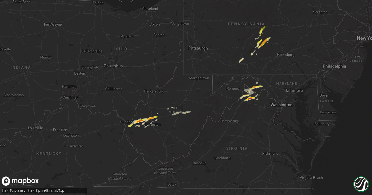
Hail Map in West Virginia on May 3, 2019
Get this storm
May 3 map
$229
one time, instant access
Download today. No call, no setup
Keep the $229
Bought the map and want the full workflow? Apply the entire $229 to a subscription within 7 days. None of it is wasted.
Every map, not just this one
This buys you this map. Subscription and you get every map we run, in the markets you choose from a few cities to whole states to nationwide. Plus real-time alerts the moment a storm fires.
Contact data
Name, contact info, occupancy, even credit band for addresses in the footprint. You go from where it hit to who to call.
Become the source they trust
Unlimited branding weather history reports on demand. You already have the documented answer ready for the property owner, and you are the one who showed up with it.
Property data and RoofTrace estimates
Pull up any address you have got, its value and the exact code rules for that jurisdiction, straight from One Click Code. Then RoofTrace estimates the squares, pitch, and roof value, priced the way you price.
Storm reports in West Virginia
West Virginia
| Date | Description |
|---|---|
| 05/03/20196:49 PM CDT | A local report indicates 1.00 inch wind near 2 E VANVILLE |
| 05/03/20196:40 PM CDT | A local report indicates 1.00 inch wind near 1 S VANVILLE |
| 05/03/20196:38 PM CDT | A local report indicates 1.00 inch wind near INWOOD |
| 05/03/20196:38 PM CDT | A local report indicates 1.00 inch wind near 1 NE INWOOD |
| 05/03/20192:37 PM CDT | Downed power lines on crummies creek rd |
| 05/03/20191:55 PM CDT | Tree down along elk river road in elkview |
| 05/03/20191:34 PM CDT | A local report indicates 1.00 inch wind near SISSONVILLE |
| 05/03/20191:29 PM CDT | Picture submitted of hail in sissonville |
| 05/03/20191:18 PM CDT | Tree down along poca river road in sissonville |
| 05/03/201912:55 PM CDT | A local report indicates 1.00 inch wind near TEAYS VALLEY |
| 05/03/201912:55 PM CDT | A local report indicates 1.00 inch wind near 2 W TEAYS VALLEY |
| 05/03/201912:50 PM CDT | Golf ball sized hail and numerous trees down were reported on teays valley road near west teays middle school. |
| 05/03/201912:50 PM CDT | Golf ball sized hail and numerous trees down were reported on teays valley road near west teays middle school. |
| 05/03/201912:40 PM CDT | Tree down on a car along glenwood road in milton |
| 05/03/201912:40 PM CDT | A local report indicates 1.50 inch wind near CULLODEN |
| 05/03/201912:40 PM CDT | Large tree down on trailer in hurricane. Time estimated from radar |
| 05/03/201912:38 PM CDT | A local report indicates 1.00 inch wind near MILTON |
| 05/03/201912:36 PM CDT | A local report indicates 1.50 inch wind near CULLODEN |
| 05/03/20193:43 AM CDT | At 843 PM EDT, severe thunderstorms were located along a line extending from near Williamsport to near Boonsboro to near Harpers Ferry, moving east at 30 mph. HAZARD...60 mph wind gusts. SOURCE...Radar indicated. IMPACT...Damaging winds will cause some trees and large branches to fall. This could injure those outdoors, as well as damage homes and vehicles. Roadways may become blocked by downed trees. Localized power outages are possible. Unsecured light objects may become projectiles. Locations impacted include... Frederick, Hagerstown, Shepherdstown, Harry Grove Stadium, Ballenger Creek, Robinwood, Walkersville, Boonsboro, Braddock Heights, Mount Aetna, Mount Lena, San Mar, Clover Hill, Discovery-Spring Garden, Wolfsville, Saint James, Linganore-Bartonsville, Halfway, Jefferson and Myersville. |
| 05/03/20192:55 AM CDT | At 755 PM EDT, severe thunderstorms were located along a line extending from near Greenwood to near Winchester, moving east at 25 mph. HAZARD...60 mph wind gusts and quarter size hail. SOURCE...Radar indicated. IMPACT...Damaging winds will cause some trees and large branches to fall. This could injure those outdoors, as well as damage homes and vehicles. Roadways may become blocked by downed trees. Localized power outages are possible. Unsecured light objects may become projectiles. Locations impacted include... Charles Town, Ranson, Inwood, Corporation Of Ranson, Middleway, Brucetown, Gerrardstown, Gainesboro, Cedar Grove, Gaylord, Clear Brook, Ridgeway, Bunker Hill, Stephenson, Wadesville, Summit Point, Cedar Hill, Albin, Stringtown and Rippon. |
| 05/03/20192:27 AM CDT | At 727 PM EDT, a severe thunderstorm was located over Inwood, or 8 miles southwest of Martinsburg, moving northeast at 20 mph. HAZARD...60 mph wind gusts and quarter size hail. SOURCE...Radar indicated. IMPACT...Damaging winds will cause some trees and large branches to fall. This could injure those outdoors, as well as damage homes and vehicles. Roadways may become blocked by downed trees. Localized power outages are possible. Unsecured light objects may become projectiles. Locations impacted include... Martinsburg, Shepherdstown, Ranson, Inwood, Kearneysville, Shenandoah Junction, Middleway, Winebrenners Cross, Gerrardstown, Vanville, Ridgeway, Bunker Hill and Martinsburg Airport. |
| 05/03/201912:06 AM CDT | At 506 PM EDT, a severe thunderstorm was located near Elkins, moving northeast at 40 mph. HAZARD...60 mph wind gusts and quarter size hail. SOURCE...Radar indicated. IMPACT...Hail damage to vehicles is expected. Expect wind damage to roofs, siding, and trees. Locations impacted include... Elkins, Philippi, Audra State Park, Belington, Mill Creek, Dailey, Beverly, Junior, Womelsdorf (Coalton), Huttonsville, Montrose, Harman, Dryfork, Glady, Nestorville, Bowden, Kerens and Ellamore.This includes Route 33 between mile markers 31 and 35. |
| 05/03/201912:05 AM CDT | At 504 PM EDT, a severe thunderstorm was located near Stephens City, or near Millwood Pike, moving east at 15 mph. HAZARD...Tennis ball size hail and 70 mph wind gusts. SOURCE...Radar indicated. IMPACT...Expect wind damage to trees and power lines. Hail is large enough to dent and damage vehicles. Some hail damage to roofs, siding, and windows is possible. Locations impacted include... Berryville, Boyce, White Post, Millwood, Nineveh, Gaylord, Armel, Bethel, Briggs and Stringtown. |
| 05/02/201911:23 PM CDT | At 423 PM EDT, a severe thunderstorm was located 7 miles northwest of Holly River State, or 14 miles east of Sutton, moving northeast at 35 mph. HAZARD...60 mph wind gusts and half dollar size hail. SOURCE...Radar indicated. IMPACT...Hail damage to vehicles is expected. Expect wind damage to roofs, siding, and trees. Locations impacted include... Dailey, Rock Cave, Holly River State, Alexander, Eden, Helvetia, Cleveland, Alton, Hacker Valley, Ellamore, Kanawha Head, Tallmansville, Overhill and French Creek.This includes Route 33 near mile marker 17. |
| 05/02/201910:58 PM CDT | At 357 PM EDT, severe thunderstorms were located along a line extending from near Grantsville to near Glenville to Sutton to near Birch River, moving northeast at 35 mph. HAZARD...Ping pong ball size hail and 60 mph wind gusts. SOURCE...Radar indicated. IMPACT...People and animals outdoors will be injured. Expect hail damage to roofs, siding, windows, and vehicles. Expect wind damage to roofs, siding, and trees. Locations impacted include... Buckhannon, Weston, Glenville, Sutton, Gassaway, Jackson Mill, Stonewall Jackson, Rock Cave, Cedar Creek State Park, Burnsville, Lost Creek, Jane Lew, Flatwoods, Sand Fork, Cleveland, Little Birch, Newberne, Alum Bridge, Kanawha Head and Ireland.This includes the following highways... Interstate 79 between mile markers 51 and 111. Route 19 between mile markers 64 and 68. Route 33 between mile markers 1 and 7. |
| 05/02/201910:42 PM CDT | At 341 PM EDT, a severe thunderstorm was located over Winchester, moving east at 15 mph. HAZARD...60 mph wind gusts and quarter size hail. SOURCE...Radar indicated. IMPACT...Damaging winds will cause some trees and large branches to fall. This could injure those outdoors, as well as damage homes and vehicles. Roadways may become blocked by downed trees. Localized power outages are possible. Unsecured light objects may become projectiles. Locations impacted include... Winchester, Millwood Pike, Stephens City, Boyce, Stephenson, Brucetown, Wadesville, Greenwood, Cedar Hill, Clear Brook, Albin and Briggs. |
| 05/02/201910:17 PM CDT | At 315 PM EDT, severe thunderstorms were located along a line extending from Spencer to 6 miles southwest of Arnoldsburg to Wallback to near Clay, moving northeast at 30 mph. HAZARD...60 mph wind gusts. SOURCE...Radar indicated. IMPACT...Expect damage to roofs, siding, and trees. Locations impacted include... Spencer, Glenville, Sutton, Grantsville, Clay, Gassaway, Arnoldsburg, Cedar Creek State Park, Big Otter, Wallback, Harrison, Burnsville, Flatwoods, Sand Fork, Pullman, Auburn, Smithville, Little Birch, Newberne and Berea.This includes the following highways... Interstate 79 between mile markers 29 and 83. Route 19 between mile markers 65 and 68. |
| 05/02/201910:06 PM CDT | At 306 PM EDT, a severe thunderstorm was located near Star Tannery, or 10 miles north of Strasburg, moving northeast at 15 mph. HAZARD...60 mph wind gusts and quarter size hail. SOURCE...Radar indicated. IMPACT...Damaging winds will cause some trees and large branches to fall. This could injure those outdoors, as well as damage homes and vehicles. Roadways may become blocked by downed trees. Localized power outages are possible. Unsecured light objects may become projectiles. Locations impacted include... Winchester, Millwood Pike, High View Manor, Gainesboro, Wilde Acres, Rock Enon Springs, Albin, Gore and Lehew. |
| 05/02/20199:55 PM CDT | At 255 PM EDT, a severe thunderstorm was located near Clendenin, or 14 miles northeast of Charleston, moving northeast at 35 mph. HAZARD...60 mph wind gusts and penny size hail. SOURCE...Radar indicated. IMPACT...Expect damage to roofs, siding, and trees. Locations impacted include... Clay, Clendenin, Wallback, Glen, Elkview, Ivydale and Procious. This includes Interstate 79 between mile markers 10 and 17, betweenmile markers 19 and 20, and between mile markers 32 and 39. |
| 05/02/20199:44 PM CDT | At 243 PM EDT, a severe thunderstorm was located 8 miles northeast of Sissonville, or 16 miles northeast of Charleston, moving northeast at 30 mph. HAZARD...60 mph wind gusts and quarter size hail. SOURCE...Radar indicated and reports. This storm has a history of producing severe hail in Sissonville. IMPACT...Hail damage to vehicles is expected. Expect wind damage to roofs, siding, and trees. Locations impacted include... Amma, Left Hand, Looneyville, Harmony, Tariff, Walton and Gandeeville.This includes Interstate 79 between mile markers 21 and 31. |
| 05/02/20198:56 PM CDT | At 155 PM EDT, a severe thunderstorm was located over Teays Valley, or near Winfield, moving east at 35 mph. HAZARD...Two inch hail and 70 mph wind gusts. SOURCE...Radar indicated. IMPACT...People and animals outdoors will be injured. Expect hail damage to roofs, siding, windows, and vehicles. Expect considerable tree damage. Wind damage is also likely to mobile homes, roofs, and outbuildings. Locations impacted include... Nitro, Winfield, St. Albans, Hurricane, Sissonville, Eleanor, Poca, Cross Lanes, Kenna, Teays Valley, Bancroft, Harmony, Kentuck and Liberty.This includes the following highways... Interstate 79 between mile markers 8 and 17. Interstate 77 in West Virginia between mile markers 107 and 127. Interstate 64 in West Virginia between mile markers 36 and 49. |
| 05/02/20198:29 PM CDT | At 129 PM EDT, a severe thunderstorm was located over Milton, or 9 miles north of Hamlin, moving east at 30 mph. HAZARD...60 mph wind gusts and half dollar size hail. SOURCE...Radar indicated. IMPACT...Hail damage to vehicles is expected. Expect wind damage to roofs, siding, and trees. Locations impacted include... Nitro, Winfield, Hurricane, Milton, Eleanor, Poca, Ona, Culloden, Teays Valley, Bancroft and Fraziers Bottom.This includes Interstate 64 in West Virginia between mile markers 23and 45. |
All States Impacted by Hail Map on May 3, 2019
Cities Impacted by Hail Map on May 3, 2019
- Seymour, TX
- Westhoff, TX
- Smiley, TX
- Paige, TX
- Greeneville, TN
- Franklin, AL
- Sonora, TX
- Austin, TX
- Eldorado, TX
- Monahans, TX
- Coyanosa, TX
- Uvalde, TX
- Rocksprings, TX
- Goldsmith, TX
- Charleston, WV
- New Braunfels, TX
- Bulverde, TX
- Junction, TX
- Stonewall, TX
- Hye, TX
- Blanco, TX
- Hurricane, WV
- Fraziers Bottom, WV
- Lockney, TX
- Cotulla, TX
- Fowlerton, TX
- Dilley, TX
- Munday, TX
- Batesville, TX
- Pearsall, TX
- Mill Creek, PA
- Allensville, PA
- Humble, TX
- Kingwood, TX
- Shubuta, MS
- Waynesboro, MS
- Friona, TX
- Earth, TX
- Sudan, TX
- Muleshoe, TX
- Fredericksburg, TX
- Comfort, TX
- Abilene, TX
- Bellefonte, PA
- State College, PA
- Barksdale, TX
- Stephens City, VA
- Front Royal, VA
- White Post, VA
- Boyce, VA
- Middletown, VA
- Winchester, VA
- Hereford, TX
- Throckmorton, TX
- Albany, TX
- Roby, TX
- Rotan, TX
- McDade, TX
- Elgin, TX
- Coahoma, TX
- Holliday, TX
- Olney, TX
- Newcastle, TX
- D Hanis, TX
- Milton, WV
- Culloden, WV
- Winfield, WV
- Scott Depot, WV
- Hebbronville, TX
- Harper, TX
- Harpers Ferry, WV
- Gerrardstown, WV
- Shenandoah Junction, WV
- Keedysville, MD
- Martinsburg, WV
- Bunker Hill, WV
- Inwood, WV
- Clear Brook, VA
- Sharpsburg, MD
- Shepherdstown, WV
- Kearneysville, WV
- Del Rio, TX
- Quitman, MS
- Kermit, TX
- Andrews, TX
- Carrizo Springs, TX
- Brackettville, TX
- Omaha, AR
- Plains, TX
- New Enterprise, PA
- Loysburg, PA
- Bedford, PA
- La Pryor, TX
- Three Rivers, TX
- Mangum, OK
- Driftwood, TX
- Wimberley, TX
- Spring, TX
- De Leon, TX
- Gorman, TX
- Millersview, TX
- Stuart, FL
- Palm City, FL
- Crystal City, TX
- Hamilton, TX
- Hico, TX
- Carlton, TX
- Gustine, TX
- Dublin, TX
- Boerne, TX
- Gatesville, TX
- Oglesby, TX
- Clyde, TX
- Johnson City, TX
- Jayton, TX
- Girard, TX
- Snyder, TX
- Magnolia, TX
- Pinehurst, TX
- Tomball, TX
- Lexington, TX
- Paris, VA
- Upperville, VA
- Sabinal, TX
- Utopia, TX
- Blackwell, TX
- Bronte, TX
- Elkview, WV
- Ona, WV
- Barboursville, WV
- Lincoln, TX
- Giddings, TX
- Somerville, TX
- Buda, TX
- Comstock, TX
- Forest Home, AL
- Marathon, TX
- Fort Stockton, TX
- Shirleysburg, PA
- Three Springs, PA
- Cuero, TX
- Yorktown, TX
- Houston, TX
- Berryville, VA
- Seminole, TX
- Star Tannery, VA
- Dripping Springs, TX
- Stephenson, VA
- Moulton, TX
- Schulenburg, TX
- Shiner, TX
- Weimar, TX
- Hallettsville, TX
- Columbus, TX
- East Bernard, TX
- Lead Hill, AR
- Roscoe, TX
- Mosheim, TN
- Realitos, TX
- Concepcion, TX
- Big Wells, TX
- Maryneal, TX
- Lavalette, WV
- Huntington, WV
- Ralls, TX
- Summerfield, TX
- San Angelo, TX
- Walton, WV
- Nitro, WV
- Poca, WV
- Ovalo, TX
- Barstow, TX
- Pyote, TX
- Brownfield, TX
- Campbellton, TX
- Tatum, NM
- Morton, TX
- Knippa, TX
- Vernon, TX
- Raymond, MN
- Kerkhoven, MN
- Murdock, MN
- Hobbs, NM
- Lovington, NM
- West Palm Beach, FL
- Del Valle, TX
- Loraine, TX
- Woodson, TX
- Graham, TX
- Huffman, TX
- Porter, TX
- Whiteface, TX
- Belleville, PA
- McClure, PA
- Milroy, PA
- Burnham, PA
- Reedsville, PA
- McVeytown, PA
- Yeagertown, PA
- Lewistown, PA
- Boalsburg, PA
- Big Spring, TX
- Gail, TX
- Huntingdon, PA
- Saint Albans, WV
- Bellville, TX
- Taft, TX
- Portland, TX
- Alice, TX
- Valley Mills, TX
- Christoval, TX
- Caldwell, TX
- Weinert, TX
- Comanche, TX
- Camp Wood, TX
- Garden City, TX
- Georgetown, TX
- Bovina, TX
- Theriot, LA
- Jupiter, FL
- Sweetwater, TX
- Menard, TX
- Nordheim, TX
- Wayne, WV
- Boynton Beach, FL
- Moran, TX
- Little Birch, WV
- Frametown, WV
- Sutton, WV
- Gassaway, WV
- Centre Hall, PA
- Eagle Lake, TX
- Maple, TX
- Enochs, TX
- Fort White, FL
- Concan, TX
- Strasburg, VA
- Rio Frio, TX
- Leakey, TX
- Laredo, TX
- Selbyville, WV
- Hacker Valley, WV
- Pickens, WV
- Diana, WV
- Cowen, WV
- Flatwoods, WV
- Rock Cave, WV
- Goree, TX
- Mapleton Depot, PA
- Todd, PA
- Calvin, PA
- Cassville, PA
- Broad Top, PA
- Kenedy, TX
- Tilden, TX
- Trout, LA
- Jena, LA
- Olla, LA
- Gore, VA
- Cross Junction, VA
- Ozona, TX
- Mount Union, PA
- Kyle, TX
- San Marcos, TX
- Lueders, TX
- Orma, WV
- Mendenhall, MS
- Braxton, MS
- Post, TX
- Justiceburg, TX
- Center Point, TX
- Hockley, TX
- Lake Butler, FL
- Kendalia, TX
- Moore, TX
- Pipe Creek, TX
- Crosby, TX
- Garwood, TX
- Alleyton, TX
- Eagle Pass, TX
- Meridian, TX
- Cranfills Gap, TX
- Flatonia, TX
- Aspermont, TX
- Evergreen, AL
- Chillicothe, TX
- Farwell, TX
- Jonesboro, TX
- Dimmitt, TX
- Bandera, TX
- Gordon, TX
- Clifton, TX
- Petersburg, PA
- Slaton, TX
- Baytown, TX
- Hamlin, TX
- Ripley, WV
- Saline, LA
- Westbrook, TX
- Summit Point, WV
- Round Mountain, TX
- Llano, TX
- Ledbetter, TX
- Charles Town, WV
- Grove Hill, AL
- Manor, TX
- Karnes City, TX
- Wingate, TX
- Sweeny, TX
- Pecos, TX
- Colorado City, TX
- Pennsylvania Furnace, PA
- Dime Box, TX
- Dale, TX
- Manchaca, TX
- Hamlin, WV
- West Hamlin, WV
- Doole, TX
- Bastrop, TX
- Spring Branch, TX
- Alum Creek, WV
- Sod, WV
- Tornado, WV
- South Charleston, WV
- Crowell, TX
- Wink, TX
- Salt Rock, WV
- Red House, WV
- Coffeeville, AL
- Normantown, WV
- Cedarville, WV
- Rosedale, WV
- Saint Augustine, FL
- Bergheim, TX
- Afton, TN
- Howard, PA
- Bishop, TX
- Benavides, TX
- Robstown, TX
- Mathis, TX
- Oilton, TX
- Corpus Christi, TX
- Odem, TX
- Agua Dulce, TX
- Sinton, TX
- Bruni, TX
- Orange Grove, TX
- San Diego, TX
- Kingsville, TX
- Mirando City, TX


