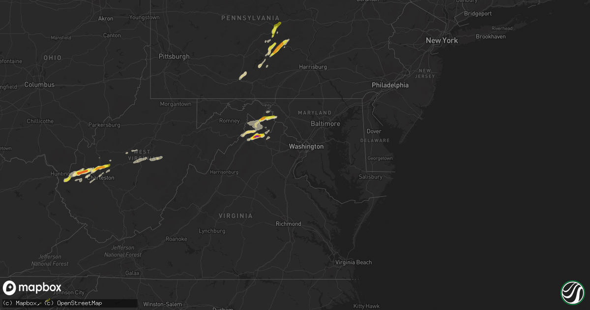
Hail Map in Maryland on May 3, 2019
Get this storm
May 3 map
$229
one time, instant access
Download today. No call, no setup
Keep the $229
Bought the map and want the full workflow? Apply the entire $229 to a subscription within 7 days. None of it is wasted.
Every map, not just this one
This buys you this map. Subscription and you get every map we run, in the markets you choose from a few cities to whole states to nationwide. Plus real-time alerts the moment a storm fires.
Contact data
Name, contact info, occupancy, even credit band for addresses in the footprint. You go from where it hit to who to call.
Become the source they trust
Unlimited branding weather history reports on demand. You already have the documented answer ready for the property owner, and you are the one who showed up with it.
Property data and RoofTrace estimates
Pull up any address you have got, its value and the exact code rules for that jurisdiction, straight from One Click Code. Then RoofTrace estimates the squares, pitch, and roof value, priced the way you price.
Storm reports in Maryland
Maryland
| Date | Description |
|---|---|
| 05/03/20193:28 AM CDT | At 828 PM EDT, severe thunderstorms were located along a line extending from Kearneysville to Berryville, moving east at 25 mph. HAZARD...60 mph wind gusts. SOURCE...Radar indicated. IMPACT...Damaging winds will cause some trees and large branches to fall. This could injure those outdoors, as well as damage homes and vehicles. Roadways may become blocked by downed trees. Localized power outages are possible. Unsecured light objects may become projectiles. Locations impacted include... Charles Town, Purcellville, Brunswick, Ranson, Round Hill, Harpers Ferry, Lovettsville, Bolivar, Shenandoah Junction, Hamilton, Rosemont, Hillsboro, Waterford, Gaylord, Petersville, Pleasantville, Millville, Lincoln and Rippon. |
| 05/03/20193:07 AM CDT | At 807 PM EDT, a severe thunderstorm was located over Kearneysville, or near Shepherdstown, moving east at 20 mph. HAZARD...Ping pong ball size hail and 60 mph wind gusts. SOURCE...Trained weather spotters have reported quarter size hail with this storm. IMPACT...Damaging winds will cause some trees and large branches to fall. This could injure those outdoors, as well as damage homes and vehicles. Roadways may become blocked by downed trees. Localized power outages are possible. Unsecured light objects may become projectiles. Locations impacted include... Shepherdstown, Boonsboro, Harpers Ferry, Keedysville, Bolivar, Sharpsburg, Shenandoah Junction, Rohrersville, Gapland, Brownsville, Antietam, Moler Crossroads, Pleasantville and Bakerton. |
| 05/02/20197:20 PM CDT | Large tree limbs snapped and dime size hail |
All States Impacted by Hail Map on May 3, 2019
Cities Impacted by Hail Map on May 3, 2019
- Seymour, TX
- Westhoff, TX
- Smiley, TX
- Paige, TX
- Greeneville, TN
- Franklin, AL
- Sonora, TX
- Austin, TX
- Eldorado, TX
- Monahans, TX
- Coyanosa, TX
- Uvalde, TX
- Rocksprings, TX
- Goldsmith, TX
- Charleston, WV
- New Braunfels, TX
- Bulverde, TX
- Junction, TX
- Stonewall, TX
- Hye, TX
- Blanco, TX
- Hurricane, WV
- Fraziers Bottom, WV
- Lockney, TX
- Cotulla, TX
- Fowlerton, TX
- Dilley, TX
- Munday, TX
- Batesville, TX
- Pearsall, TX
- Mill Creek, PA
- Allensville, PA
- Humble, TX
- Kingwood, TX
- Shubuta, MS
- Waynesboro, MS
- Friona, TX
- Earth, TX
- Sudan, TX
- Muleshoe, TX
- Fredericksburg, TX
- Comfort, TX
- Abilene, TX
- Bellefonte, PA
- State College, PA
- Barksdale, TX
- Stephens City, VA
- Front Royal, VA
- White Post, VA
- Boyce, VA
- Middletown, VA
- Winchester, VA
- Hereford, TX
- Throckmorton, TX
- Albany, TX
- Roby, TX
- Rotan, TX
- McDade, TX
- Elgin, TX
- Coahoma, TX
- Holliday, TX
- Olney, TX
- Newcastle, TX
- D Hanis, TX
- Milton, WV
- Culloden, WV
- Winfield, WV
- Scott Depot, WV
- Hebbronville, TX
- Harper, TX
- Harpers Ferry, WV
- Gerrardstown, WV
- Shenandoah Junction, WV
- Keedysville, MD
- Martinsburg, WV
- Bunker Hill, WV
- Inwood, WV
- Clear Brook, VA
- Sharpsburg, MD
- Shepherdstown, WV
- Kearneysville, WV
- Del Rio, TX
- Quitman, MS
- Kermit, TX
- Andrews, TX
- Carrizo Springs, TX
- Brackettville, TX
- Omaha, AR
- Plains, TX
- New Enterprise, PA
- Loysburg, PA
- Bedford, PA
- La Pryor, TX
- Three Rivers, TX
- Mangum, OK
- Driftwood, TX
- Wimberley, TX
- Spring, TX
- De Leon, TX
- Gorman, TX
- Millersview, TX
- Stuart, FL
- Palm City, FL
- Crystal City, TX
- Hamilton, TX
- Hico, TX
- Carlton, TX
- Gustine, TX
- Dublin, TX
- Boerne, TX
- Gatesville, TX
- Oglesby, TX
- Clyde, TX
- Johnson City, TX
- Jayton, TX
- Girard, TX
- Snyder, TX
- Magnolia, TX
- Pinehurst, TX
- Tomball, TX
- Lexington, TX
- Paris, VA
- Upperville, VA
- Sabinal, TX
- Utopia, TX
- Blackwell, TX
- Bronte, TX
- Elkview, WV
- Ona, WV
- Barboursville, WV
- Lincoln, TX
- Giddings, TX
- Somerville, TX
- Buda, TX
- Comstock, TX
- Forest Home, AL
- Marathon, TX
- Fort Stockton, TX
- Shirleysburg, PA
- Three Springs, PA
- Cuero, TX
- Yorktown, TX
- Houston, TX
- Berryville, VA
- Seminole, TX
- Star Tannery, VA
- Dripping Springs, TX
- Stephenson, VA
- Moulton, TX
- Schulenburg, TX
- Shiner, TX
- Weimar, TX
- Hallettsville, TX
- Columbus, TX
- East Bernard, TX
- Lead Hill, AR
- Roscoe, TX
- Mosheim, TN
- Realitos, TX
- Concepcion, TX
- Big Wells, TX
- Maryneal, TX
- Lavalette, WV
- Huntington, WV
- Ralls, TX
- Summerfield, TX
- San Angelo, TX
- Walton, WV
- Nitro, WV
- Poca, WV
- Ovalo, TX
- Barstow, TX
- Pyote, TX
- Brownfield, TX
- Campbellton, TX
- Tatum, NM
- Morton, TX
- Knippa, TX
- Vernon, TX
- Raymond, MN
- Kerkhoven, MN
- Murdock, MN
- Hobbs, NM
- Lovington, NM
- West Palm Beach, FL
- Del Valle, TX
- Loraine, TX
- Woodson, TX
- Graham, TX
- Huffman, TX
- Porter, TX
- Whiteface, TX
- Belleville, PA
- McClure, PA
- Milroy, PA
- Burnham, PA
- Reedsville, PA
- McVeytown, PA
- Yeagertown, PA
- Lewistown, PA
- Boalsburg, PA
- Big Spring, TX
- Gail, TX
- Huntingdon, PA
- Saint Albans, WV
- Bellville, TX
- Taft, TX
- Portland, TX
- Alice, TX
- Valley Mills, TX
- Christoval, TX
- Caldwell, TX
- Weinert, TX
- Comanche, TX
- Camp Wood, TX
- Garden City, TX
- Georgetown, TX
- Bovina, TX
- Theriot, LA
- Jupiter, FL
- Sweetwater, TX
- Menard, TX
- Nordheim, TX
- Wayne, WV
- Boynton Beach, FL
- Moran, TX
- Little Birch, WV
- Frametown, WV
- Sutton, WV
- Gassaway, WV
- Centre Hall, PA
- Eagle Lake, TX
- Maple, TX
- Enochs, TX
- Fort White, FL
- Concan, TX
- Strasburg, VA
- Rio Frio, TX
- Leakey, TX
- Laredo, TX
- Selbyville, WV
- Hacker Valley, WV
- Pickens, WV
- Diana, WV
- Cowen, WV
- Flatwoods, WV
- Rock Cave, WV
- Goree, TX
- Mapleton Depot, PA
- Todd, PA
- Calvin, PA
- Cassville, PA
- Broad Top, PA
- Kenedy, TX
- Tilden, TX
- Trout, LA
- Jena, LA
- Olla, LA
- Gore, VA
- Cross Junction, VA
- Ozona, TX
- Mount Union, PA
- Kyle, TX
- San Marcos, TX
- Lueders, TX
- Orma, WV
- Mendenhall, MS
- Braxton, MS
- Post, TX
- Justiceburg, TX
- Center Point, TX
- Hockley, TX
- Lake Butler, FL
- Kendalia, TX
- Moore, TX
- Pipe Creek, TX
- Crosby, TX
- Garwood, TX
- Alleyton, TX
- Eagle Pass, TX
- Meridian, TX
- Cranfills Gap, TX
- Flatonia, TX
- Aspermont, TX
- Evergreen, AL
- Chillicothe, TX
- Farwell, TX
- Jonesboro, TX
- Dimmitt, TX
- Bandera, TX
- Gordon, TX
- Clifton, TX
- Petersburg, PA
- Slaton, TX
- Baytown, TX
- Hamlin, TX
- Ripley, WV
- Saline, LA
- Westbrook, TX
- Summit Point, WV
- Round Mountain, TX
- Llano, TX
- Ledbetter, TX
- Charles Town, WV
- Grove Hill, AL
- Manor, TX
- Karnes City, TX
- Wingate, TX
- Sweeny, TX
- Pecos, TX
- Colorado City, TX
- Pennsylvania Furnace, PA
- Dime Box, TX
- Dale, TX
- Manchaca, TX
- Hamlin, WV
- West Hamlin, WV
- Doole, TX
- Bastrop, TX
- Spring Branch, TX
- Alum Creek, WV
- Sod, WV
- Tornado, WV
- South Charleston, WV
- Crowell, TX
- Wink, TX
- Salt Rock, WV
- Red House, WV
- Coffeeville, AL
- Normantown, WV
- Cedarville, WV
- Rosedale, WV
- Saint Augustine, FL
- Bergheim, TX
- Afton, TN
- Howard, PA
- Bishop, TX
- Benavides, TX
- Robstown, TX
- Mathis, TX
- Oilton, TX
- Corpus Christi, TX
- Odem, TX
- Agua Dulce, TX
- Sinton, TX
- Bruni, TX
- Orange Grove, TX
- San Diego, TX
- Kingsville, TX
- Mirando City, TX


