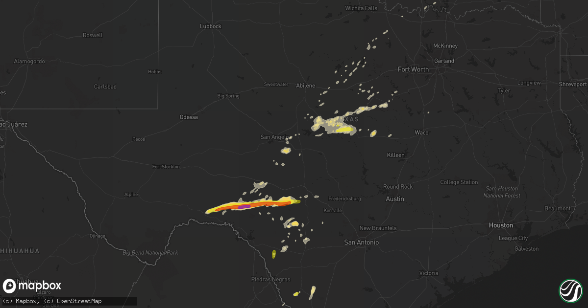
Hail Map in Texas on May 3, 2018
Get this storm
May 3 map
$229
one time, instant access
Download today. No call, no setup
Keep the $229
Bought the map and want the full workflow? Apply the entire $229 to a subscription within 7 days. None of it is wasted.
Every map, not just this one
This buys you this map. Subscription and you get every map we run, in the markets you choose from a few cities to whole states to nationwide. Plus real-time alerts the moment a storm fires.
Contact data
Name, contact info, occupancy, even credit band for addresses in the footprint. You go from where it hit to who to call.
Become the source they trust
Unlimited branding weather history reports on demand. You already have the documented answer ready for the property owner, and you are the one who showed up with it.
Property data and RoofTrace estimates
Pull up any address you have got, its value and the exact code rules for that jurisdiction, straight from One Click Code. Then RoofTrace estimates the squares, pitch, and roof value, priced the way you price.
Storm reports in Texas
Texas
| Date | Description |
|---|---|
| 05/03/20184:00 PM CDT | Damaging wind rolled an empty horse trailer into a tree. Trees down and numerous large limbs down. |
| 05/03/201810:20 AM CDT | Multiple tree limbs down near trinity park |
| 05/03/201810:10 AM CDT | Multiple trees uprooted along cr 1006/cr 1126 near godley. |
| 05/03/20189:48 AM CDT | Power lines down near the intersection of hwy 171 and 51 south of weatherford. |
| 05/03/20188:52 AM CDT | Signs being blown off poles on south side of jacksboro near movie theater and txdot office. |
| 05/03/20187:17 AM CDT | At 1216 AM CDT, a severe thunderstorm was located near Loveland, moving northeast at 65 mph. HAZARD...60 mph wind gusts and nickel size hail. SOURCE...Radar indicated. IMPACT...Expect damage to roofs, siding, and trees. Locations impacted include... Lawton, Duncan, Burkburnett, Marlow, Frederick, Walters, Cache, Electra, Elgin, Comanche, Apache, Snyder, Geronimo, Fletcher, Grandfield, Temple, Sterling, Chattanooga, Randlett and Mountain Park.This includes Interstate 44 between mile markers 0 and 62. |
| 05/03/20187:11 AM CDT | At 1211 AM CDT, a severe thunderstorm was located 12 miles southeast of Ozona, moving northeast at 40 mph. HAZARD...60 mph wind gusts and quarter size hail. SOURCE...Radar indicated. IMPACT...Hail damage to vehicles is expected. Expect wind damage to roofs, siding, and trees. This severe thunderstorm will be near, Eldorado around 100 AM CDT. Other locations impacted by this severe thunderstorm include TheIntersection Of Ranch Road 1828 And Ranch Road 915, The IntersectionOf Us-190 And Ranch Road 1828, I-10 Near The Crockett-Sutton County Line, The Intersection Of I-10 And Ranch Road 1989 and Us-277 Near The Sutton-Schleicher County Line.This includes Interstate 10 between Mile Markers 370 and 396. |
| 05/03/20187:11 AM CDT | At 1210 AM CDT, a severe thunderstorm was located 4 miles south of Westover, moving northeast at 35 mph. HAZARD...60 mph wind gusts and quarter size hail. SOURCE...Radar indicated. IMPACT...Hail damage to vehicles is expected. Expect wind damage to roofs, siding, and trees. Locations impacted include... Archer City, Megargel, Westover and Lake Kickapoo. |
| 05/03/20186:18 AM CDT | At 1118 PM CDT, a severe thunderstorm was located near Brackettville, moving northeast at 20 mph. HAZARD...Ping pong ball size hail and 60 mph wind gusts. SOURCE...Radar indicated. IMPACT...People and animals outdoors will be injured. Expect hail damage to roofs, siding, windows, and vehicles. Expect wind damage to roofs, siding, and trees. Locations impacted include... Brackettville, Spofford, Anacacho, Alamo Village, Turkey Mountain, and Fort Clark Springs. |
| 05/03/20185:52 AM CDT | At 1051 PM CDT, a severe thunderstorm was located near Darling, or 9 miles southwest of Spofford, moving north at 10 mph. HAZARD...60 mph wind gusts and quarter size hail. SOURCE...Radar indicated. IMPACT...Hail damage to vehicles is expected. Expect wind damage to roofs, siding, and trees. Locations impacted include... Spofford, Darling, and Laughlin AFB Aux Field. |
| 05/03/20185:14 AM CDT | At 1014 PM CDT, a severe thunderstorm was located 10 miles southwest of Carrizo Springs, moving north at 10 mph. HAZARD...60 mph wind gusts and quarter size hail. SOURCE...Radar indicated. IMPACT...Hail damage to vehicles is expected. Expect wind damage to roofs, siding, and trees. Locations impacted include... Carrizo Springs. |
| 05/03/20185:09 AM CDT | At 1009 AM CDT, a severe thunderstorm was located near Godley, or near Joshua, moving northeast at 60 mph. HAZARD...70 mph wind gusts. SOURCE...Radar indicated. IMPACT...Expect considerable tree damage. Damage is likely to mobile homes, roofs, and outbuildings. Locations impacted include... Fort Worth, Arlington, Grand Prairie, Mansfield, Haltom City, Hurst, Burleson, Cleburne, Benbrook, Crowley, Forest Hill, Richland Hills, Kennedale, Everman, Keene, Joshua, Alvarado, Rendon, Venus and Edgecliff Village. |
| 05/03/20183:56 AM CDT | At 856 AM CDT, a severe thunderstorm was located near Chico, or near Bridgeport, moving northeast at 65 mph. HAZARD...65 mph wind gusts and quarter size hail. SOURCE...Radar indicated. IMPACT...Hail damage to vehicles is expected. Expect wind damage to roofs, siding, and trees. Locations impacted include... Decatur, Bridgeport, Briar, Alvord, Aurora, Boyd, Chico, Paradise, Cottondale, Forestburg, Sunset, Boonsville, Runaway Bay and Lake Bridgeport. |
| 05/03/20183:47 AM CDT | At 846 AM CDT, a severe thunderstorm was located over Camp Bowie, or near Early, moving east at 40 mph. HAZARD...65 mph wind gusts and half dollar size hail. SOURCE...Radar indicated. IMPACT...Hail damage to vehicles is expected. Expect wind damage to roofs, siding, and trees. Locations impacted include... Comanche, De Leon, Goldthwaite, Gustine and Mullin. |
| 05/03/20183:43 AM CDT | At 843 PM CDT, a severe thunderstorm was located 9 miles south of Cienegas Terrace, or 9 miles southwest of Del Rio, moving north at 25 mph. HAZARD...60 mph wind gusts and half dollar size hail. SOURCE...Radar indicated. IMPACT...Hail damage to vehicles is expected. Expect wind damage to roofs, siding, and trees. Locations impacted include... Del Rio, Lake View, Amistad Village, Amistad Recreation Area - Governors Landing, Amistad Recreation Area - Diablo East, Amistad Recreation Area - Black Brush Point, Amanda, Laughlin AFB, Amistad Recreation Area - Long Point, Val Verde Park, Cienegas Terrace, Amistad Recreation Area - Rock Quarry Campground, Amistad Recreation Area - San Pedro Canyon, Amistad Recreation Area - Rough Canyon, Amistad Recreation Area - Spur 406 Campground, Amistad Recreation Area - 277 North Campground and Amistad Recreation Area - 277 South Boat Ramp. |
| 05/03/20183:31 AM CDT | At 830 AM CDT, a severe thunderstorm was located over Bangs, or near Brownwood, moving east at 45 mph. HAZARD...60 mph wind gusts and quarter size hail. SOURCE...Radar indicated. IMPACT...Hail damage to vehicles is expected. Expect wind damage to roofs, siding, and trees. This severe thunderstorm will be near, Brownwood and Camp Bowie around 840 AM CDT. Early around 845 AM CDT. Blanket and Zephyr around 855 AM CDT. Other locations impacted by this severe thunderstorm include IndianCreek, Owens and Thrifty. |
| 05/03/20183:27 AM CDT | At 825 AM CDT, severe thunderstorms were located along a line extending from 9 miles west of Graford to near Gordon to 13 miles northwest of Huckabay to 11 miles southeast of Ranger, moving northeast at 45 mph. HAZARD...65 mph wind gusts and quarter size hail. SOURCE...Radar indicated. IMPACT...Hail damage to vehicles is expected. Expect wind damage to roofs, siding, and trees. Locations impacted include... Weatherford, Mineral Wells, Graford, Gordon, Lipan, Cool, Poolville, Mineral Wells State Park, Huckabay, Strawn, Millsap and Mingus.This includes Interstate 20 between mile markers 360 and 404. |
| 05/03/20183:13 AM CDT | At 812 AM CDT, a severe thunderstorm was located over Possum Kingdom State Park, or 14 miles south of Graham, moving northeast at 55 mph. HAZARD...60 mph wind gusts. SOURCE...Radar indicated. IMPACT...Expect damage to roofs, siding, and trees. Locations impacted include... Graham, Jacksboro, Bryson and Newport. |
| 05/03/20182:48 AM CDT | At 748 AM CDT, severe thunderstorms were located along a line extending from Breckenridge to near Gunsight to 6 miles east of Cross Plains, moving northeast at 55 mph. HAZARD...60 mph wind gusts and quarter size hail. SOURCE...Radar indicated. IMPACT...Hail damage to vehicles is expected. Expect wind damage to roofs, siding, and trees. Locations impacted include... Breckenridge, Eastland, Cisco, Ranger, Gorman, Rising Star, Gordon, Necessity, Possum Kingdom State Park, Gunsight, Crystal Falls, Strawn, Carbon, Mingus and Us-180 Near The Shackelford- Stephens County Line.This includes Interstate 20 between mile markers 324 and 363, andbetween mile markers 368 and 370. |
| 05/03/20182:17 AM CDT | At 716 AM CDT, a severe thunderstorm was located 9 miles west of Sonora, moving east at 30 mph. HAZARD...60 mph wind gusts and quarter size hail. SOURCE...Radar indicated. IMPACT...Hail damage to vehicles is expected. Expect wind damage to roofs, siding, and trees. This severe thunderstorm will be near, Sonora around 735 AM CDT. Other locations impacted by this severe thunderstorm include Us-277 Near The Sutton-Schleicher County Line, The Intersection Of Ranch Road 2596 And RanchRoad 864 and The Intersection Of I-10 And Ranch Road 1989.This includes Interstate 10 between Mile Markers 382 and 420. |
| 05/03/20182:14 AM CDT | At 713 AM CDT, a severe thunderstorm was located over Olney, moving northeast at 55 mph. HAZARD...60 mph wind gusts. SOURCE...Radar indicated. IMPACT...Expect damage to roofs, siding, and trees. Locations impacted include... Olney and Newcastle. |
| 05/03/20181:11 AM CDT | At 610 AM CDT, a severe thunderstorm was located over Twin Buttes Reservoir, or 9 miles southwest of San Angelo, moving east at 35 mph. HAZARD...60 mph wind gusts and quarter size hail. SOURCE...Radar indicated. IMPACT...Hail damage to vehicles is expected. Expect wind damage to roofs, siding, and trees. This severe thunderstorm will be near, San Angelo and Twin Buttes Reservoir around 615 AM CDT. Lake Nasworthy around 620 AM CDT. Goodfellow Air Force Base around 630 AM CDT. Wall around 640 AM CDT. Vancourt around 655 AM CDT. |
| 05/03/20181:02 AM CDT | At 602 AM CDT, severe thunderstorms were located along a line extending from near Cache to 3 miles north of Cookietown, moving northeast at 70 mph. HAZARD...60 mph wind gusts and quarter size hail. SOURCE...Radar indicated. IMPACT...Hail damage to vehicles is expected. Expect wind damage to roofs, siding, and trees. Locations impacted include... Lawton, Walters, Elgin, Geronimo, Fletcher, Grandfield, Temple, Sterling, Randlett, Medicine Park, Devol, Meers, Cookietown, Lake Lawtonka, Fort Sill, Lake Ellsworth, Hulen, Taylor and eastern Wichita Mountains Wildlife Refuge.This includes Interstate 44 between mile markers 5 and 63. |
| 05/03/201812:46 AM CDT | At 544 AM CDT, a severe thunderstorm was located 7 miles southeast of Robert Lee, moving rapidly northeast at 50 mph. HAZARD...60 mph wind gusts and quarter size hail. SOURCE...Radar indicated. IMPACT...Hail damage to vehicles is expected. Expect wind damage to roofs, siding, and trees. This severe thunderstorm will be near, Tennyson around 550 AM CDT. Bronte around 555 AM CDT. Maverick around 600 AM CDT. Norton around 605 AM CDT. Winters and Wingate around 615 AM CDT. Other locations impacted by this severe thunderstorm include TheIntersection Of Highway 208 And Ranch Road 2662, Wilmeth, LakeWinters Lake, Ballinger Lake and Pumphrey. |
| 05/03/201812:22 AM CDT | At 521 AM CDT, a severe thunderstorm was located over Water Valley, or 19 miles northwest of San Angelo, moving rapidly northeast at 50 mph. HAZARD...60 mph wind gusts and quarter size hail. SOURCE...Radar indicated. IMPACT...Hail damage to vehicles is expected. Expect wind damage to roofs, siding, and trees. This severe thunderstorm will be near, Grape Creek around 530 AM CDT. Other locations impacted by this severe thunderstorm include TheIntersection Of Highway 208 And Ranch Road 2662 and Us-87 Near The Coke-Tom Green County Line. |
| 05/02/201811:37 PM CDT | At 437 AM CDT, severe thunderstorms were located along a line extending from 6 miles west of Medicine Mound to 3 miles north of Benjamin, moving east at 45 mph. HAZARD...60 mph wind gusts and quarter size hail. SOURCE...Radar indicated. IMPACT...Hail damage to vehicles is expected. Expect wind damage to roofs, siding, and trees. Locations impacted include... Crowell, Benjamin, Red Springs, Margaret, Vera, Medicine Mound, Thalia, Truscott, Gilliland, Rhineland, Rayland and Copper Breaks State Park. |
| 05/02/201811:09 PM CDT | At 408 AM CDT, a severe thunderstorm was located near Reagan County Airport, or near Big Lake, moving northeast at 35 mph. HAZARD...60 mph wind gusts and half dollar size hail. SOURCE...Radar indicated. IMPACT...Hail damage to vehicles is expected. Expect wind damage to roofs, siding, and trees. This severe thunderstorm will remain over mainly rural areas of southeastern Reagan County. |
All States Impacted by Hail Map on May 3, 2018
Cities Impacted by Hail Map on May 3, 2018
- Jacksboro, TX
- Duncan, OK
- Iredell, TX
- Hico, TX
- White City, KS
- Schuyler, NE
- Bellwood, NE
- Morse Bluff, NE
- Rogers, NE
- Linwood, NE
- Columbus, NE
- David City, NE
- North Bend, NE
- Desdemona, TX
- De Leon, TX
- Comstock, TX
- New Cambria, KS
- Victoria, KS
- Gorham, KS
- Brownwood, TX
- Evant, TX
- Zephyr, TX
- Early, TX
- Mullin, TX
- Brookesmith, TX
- Concan, TX
- Uvalde, TX
- Coleman, TX
- Sonora, TX
- Del Rio, TX
- Dryden, TX
- Rocksprings, TX
- Carrizo Springs, TX
- Asherton, TX
- Council Grove, KS
- Herington, KS
- Laredo, TX
- Elmore City, OK
- Davis, OK
- Hennepin, OK
- Tussy, OK
- Big Wells, TX
- Barksdale, TX
- Camp Wood, TX
- Arlington, NE
- Blair, NE
- Nickerson, NE
- Herman, NE
- Bennington, KS
- Solomon, KS
- Tescott, KS
- Salina, KS
- Ranger, TX
- Russell, KS
- Hays, KS
- Walker, KS
- Centralia, KS
- Vermillion, KS
- Hope, KS
- Pauls Valley, OK
- Wynnewood, OK
- Stratford, OK
- Lewiston, NE
- Burchard, NE
- Steinauer, NE
- Pleasanton, NE
- Eden, TX
- Dublin, TX
- Comanche, TX
- Hillsboro, TX
- Malone, TX
- Brackettville, TX
- Mereta, TX
- Paint Rock, TX
- Waukee, IA
- Urbandale, IA
- Grimes, IA
- West Des Moines, IA
- Cumming, IA
- Van Meter, IA
- Clive, IA
- Blanket, TX
- May, TX
- Maysville, OK
- Utopia, TX
- Leakey, TX
- Beverly, KS
- Lincoln, KS
- Stephenville, TX
- Graford, TX
- Baird, TX
- Walnut Springs, TX
- Talpa, TX
- Goldthwaite, TX
- Abilene, KS
- Ozona, TX
- Vancourt, TX
- Glen Rose, TX
- Ravenna, NE
- Gibbon, NE
- Poseyville, IN
- Christoval, TX
- Eldorado, TX
- Kingston, OK
- Lebanon, OK
- Sabinal, TX
- Junction, TX
- Riverdale, NE
- Sylvan Grove, KS
- Brookville, KS
- Breckenridge, TX
- Caddo, TX
- Hooper, NE
- Rising City, NE
- Bruno, NE
- San Angelo, TX
- Eola, TX
- Medina, TX
- Voss, TX
- Sidney, TX
- Santa Anna, TX
- Bangs, TX
- Gouldbusk, TX
- Valera, TX
- Villisca, IA
- Albion, IL
- Rockwood, TX
- Bryson, TX
- Liberty, NE
- Tecumseh, NE
- Crab Orchard, NE
- Eastland, TX
- Kearney, NE
- Cairo, NE
- Arbela, MO
- Marietta, OK
- Catarina, TX
- Ames, NE
- Fremont, NE
- Cleburne, TX
- Granbury, TX
- Rainbow, TX
- Amherst, NE
- Gatesville, TX
- Marlow, OK
- Hamilton, TX
- Foster, OK
- Burkett, TX
- Cross Plains, TX
- Chico, TX
- Saint George, KS
- Bluff Dale, TX
- Ratliff City, OK
- Westmoreland, KS
- Bowie, TX
- Moran, TX
- Cisco, TX
- Sulphur, OK
- Wewoka, OK
- Seminole, OK
- Graham, TX
- Strawn, TX
- Dodge, NE
- Rio Frio, TX
- Saint Jo, TX
- Wall, TX
- Smithville, MO
- Trimble, MO
- Plattsburg, MO
- Bone Gap, IL


