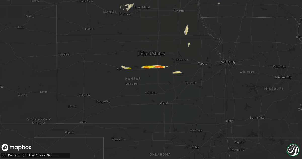
Hail Map in Kansas on May 3, 2018
Get this storm
May 3 map
$229
one time, instant access
Download today. No call, no setup
Keep the $229
Bought the map and want the full workflow? Apply the entire $229 to a subscription within 7 days. None of it is wasted.
Every map, not just this one
This buys you this map. Subscription and you get every map we run, in the markets you choose from a few cities to whole states to nationwide. Plus real-time alerts the moment a storm fires.
Contact data
Name, contact info, occupancy, even credit band for addresses in the footprint. You go from where it hit to who to call.
Become the source they trust
Unlimited branding weather history reports on demand. You already have the documented answer ready for the property owner, and you are the one who showed up with it.
Property data and RoofTrace estimates
Pull up any address you have got, its value and the exact code rules for that jurisdiction, straight from One Click Code. Then RoofTrace estimates the squares, pitch, and roof value, priced the way you price.
Storm reports in Kansas
Kansas
| Date | Description |
|---|---|
| 05/03/20186:20 PM CDT | A local report indicates 1.00 inch wind near WNW RUSSELL |
| 05/03/20185:19 AM CDT | At 1019 PM CDT, a severe thunderstorm was located 6 miles north of Auburn, moving east at 45 mph. HAZARD...60 mph wind gusts. SOURCE...Radar indicated. IMPACT...Expect damage to roofs, siding, and trees. This severe thunderstorm will be near, Topeka, Pauline and Berryton around 1030 PM CDT. Tecumseh and Grantville around 1035 PM CDT. Southwestern Lawrence, Perry, Lecompton, Clinton, Clinton Lake and Williamstown around 1045 PM CDT. This includes the following highways... Interstate 70 between mile markers 349 and 355. Kansas Turnpike between mile markers 169 and 198. |
| 05/03/20184:38 AM CDT | At 937 PM CDT, a severe thunderstorm was located 8 miles southeast of Alta Vista, moving east at 45 mph. HAZARD...60 mph wind gusts and nickel size hail. SOURCE...Radar indicated. IMPACT...Expect damage to roofs, siding, and trees. This severe thunderstorm will be near, Eskridge around 955 PM CDT. Harveyville around 1010 PM CDT. Burlingame and Scranton around 1015 PM CDT. This includes Kansas Turnpike between mile markers 150 and 168. |
| 05/03/20184:24 AM CDT | At 924 PM CDT, a severe thunderstorm was located 8 miles northwest of Volland, moving east at 35 mph. HAZARD...60 mph wind gusts and nickel size hail. SOURCE...Trained weather spotters. IMPACT...Expect damage to roofs, siding, and trees. This severe thunderstorm will be near, Volland around 935 PM CDT. Alma around 945 PM CDT. McFarland around 950 PM CDT. Paxico around 955 PM CDT. Maple Hill and Keene around 1010 PM CDT. Rossville, Dover and Willard around 1015 PM CDT. This includes Interstate 70 between mile markers 307 and 348. |
| 05/03/20184:09 AM CDT | At 908 PM CDT, a severe thunderstorm was located over Latimer, moving east at 40 mph. HAZARD...60 mph wind gusts and quarter size hail. SOURCE...Radar indicated. IMPACT...Hail damage to vehicles is expected. Expect wind damage to roofs, siding, and trees. Locations impacted include... White City, Parkerville, Latimer and Council Grove Lake. |
| 05/03/20184:09 AM CDT | At 909 PM CDT, a severe thunderstorm was located near Lane, or 11 miles southwest of Osawatomie, moving northeast at 35 mph. HAZARD...60 mph wind gusts and quarter size hail. SOURCE...Radar indicated. IMPACT...Hail damage to vehicles is expected. Expect wind damage to roofs, siding, and trees. Locations impacted include... Paola, Osawatomie, La Cygne, Linn Valley, Fontana, Hillsdale, Wagstaff, Chiles, New Lancaster and Beagle. |
| 05/03/20183:36 AM CDT | At 836 PM CDT, a severe thunderstorm was located near Harris, moving east at 35 mph. HAZARD...60 mph wind gusts and quarter size hail. SOURCE...Radar indicated. IMPACT...Hail damage to vehicles is expected. Expect wind damage to roofs, siding, and trees. This severe thunderstorm will be near, Harris around 845 PM CDT. Garnett and Richmond around 900 PM CDT. Greeley around 910 PM CDT. Lane around 915 PM CDT. |
| 05/03/20183:11 AM CDT | At 811 PM CDT, a severe thunderstorm was located near Niles, moving east at 45 mph. HAZARD...Ping pong ball size hail and 60 mph wind gusts. SOURCE...Trained weather spotters. IMPACT...People and animals outdoors will be injured. Expect hail damage to roofs, siding, windows, and vehicles. Expect wind damage to roofs, siding, and trees. This severe thunderstorm will be near, Solomon around 815 PM CDT. Abilene around 825 PM CDT. Enterprise and Moonlight around 835 PM CDT. Chapman around 840 PM CDT. Junction City around 845 PM CDT. This includes Interstate 70 between mile markers 267 and 296. |
| 05/03/20182:42 AM CDT | At 742 PM CDT, a severe thunderstorm was located over Culver, moving east at 55 mph. HAZARD...60 mph wind gusts and half dollar size hail. SOURCE...Trained weather spotters. IMPACT...Hail damage to vehicles is expected. Expect wind damage to roofs, siding, and trees. This severe thunderstorm will be near, Bennington around 755 PM CDT. Niles around 800 PM CDT. Solomon around 805 PM CDT. Manchester around 810 PM CDT. Abilene and Talmage around 815 PM CDT. This includes Interstate 70 between mile markers 267 and 276. |
| 05/03/20182:29 AM CDT | At 729 PM CDT, a severe thunderstorm was located 6 miles south of Beverly, or 13 miles southeast of Lincoln, moving east at 40 mph. HAZARD...Quarter to Half dollar size hail. SOURCE...Radar indicated. IMPACT...Damage to vehicles is expected. Locations impacted include... Salina, Beverly, New Cambria, Glendale and Westfall. This includes the following highways... Interstate 135 between Mile Markers 94 and 95. Interstate 70 between Mile Markers 229 and 266. |
| 05/03/20181:57 AM CDT | At 657 PM CDT, a severe thunderstorm was located near Vermillion, moving north at 50 mph. HAZARD...Quarter size hail. SOURCE...Radar indicated. IMPACT...Damage to vehicles is expected. This severe thunderstorm will be near, Baileyville around 705 PM CDT. Seneca and Axtell around 710 PM CDT. Bern around 720 PM CDT. |
| 05/03/20181:21 AM CDT | At 621 PM CDT, a severe thunderstorm was located near Russell, moving east at 40 mph. HAZARD...Quarter size hail. SOURCE...Radar indicated. IMPACT...Damage to vehicles is expected. Locations impacted include... Russell, Ellsworth, Wilson, Kanopolis, Dorrance, Bunker Hill, Wilson State Park, Ellsworth Airport, Wilson Lake and Russell Airport.This includes Interstate 70 between Mile Markers 183 and 226. |
| 05/03/20181:14 AM CDT | At 614 PM CDT, a severe thunderstorm was located over Westmoreland, moving northeast at 25 mph. HAZARD...Quarter size hail. SOURCE...Radar indicated. IMPACT...Damage to vehicles is expected. This severe thunderstorm will be near, Blaine around 630 PM CDT. Wheaton around 640 PM CDT. Lillis around 655 PM CDT. |
| 05/02/20189:23 PM CDT | A local report indicates 60 MPH wind near 8 ESE GRANDVIEW PLAZA |
| 05/02/20188:22 PM CDT | Law enforcement reported. |
| 05/02/20188:19 PM CDT | Tree and outbuilding damage. Wind speeds estimated at 60-90 mph. |
| 05/02/20188:08 PM CDT | Mixed hail of quarter to golf ball sized hail. Corrected for time. |
| 05/02/20188:06 PM CDT | Tree and outbuilding damage. Wind speeds estimated 75 mph. |
| 05/02/20187:45 PM CDT | Mixed hail of quarter to golf ball sized hail. |
| 05/02/20187:27 PM CDT | Reported by sherriff deputy in westfall. Hail mixed in with quarter sized hail. |
| 05/02/20187:27 PM CDT | Quarter and half dollar sized hail just south of westfall. |
All States Impacted by Hail Map on May 3, 2018
Cities Impacted by Hail Map on May 3, 2018
- Jacksboro, TX
- Duncan, OK
- Iredell, TX
- Hico, TX
- White City, KS
- Schuyler, NE
- Bellwood, NE
- Morse Bluff, NE
- Rogers, NE
- Linwood, NE
- Columbus, NE
- David City, NE
- North Bend, NE
- Desdemona, TX
- De Leon, TX
- Comstock, TX
- New Cambria, KS
- Victoria, KS
- Gorham, KS
- Brownwood, TX
- Evant, TX
- Zephyr, TX
- Early, TX
- Mullin, TX
- Brookesmith, TX
- Concan, TX
- Uvalde, TX
- Coleman, TX
- Sonora, TX
- Del Rio, TX
- Dryden, TX
- Rocksprings, TX
- Carrizo Springs, TX
- Asherton, TX
- Council Grove, KS
- Herington, KS
- Laredo, TX
- Elmore City, OK
- Davis, OK
- Hennepin, OK
- Tussy, OK
- Big Wells, TX
- Barksdale, TX
- Camp Wood, TX
- Arlington, NE
- Blair, NE
- Nickerson, NE
- Herman, NE
- Bennington, KS
- Solomon, KS
- Tescott, KS
- Salina, KS
- Ranger, TX
- Russell, KS
- Hays, KS
- Walker, KS
- Centralia, KS
- Vermillion, KS
- Hope, KS
- Pauls Valley, OK
- Wynnewood, OK
- Stratford, OK
- Lewiston, NE
- Burchard, NE
- Steinauer, NE
- Pleasanton, NE
- Eden, TX
- Dublin, TX
- Comanche, TX
- Hillsboro, TX
- Malone, TX
- Brackettville, TX
- Mereta, TX
- Paint Rock, TX
- Waukee, IA
- Urbandale, IA
- Grimes, IA
- West Des Moines, IA
- Cumming, IA
- Van Meter, IA
- Clive, IA
- Blanket, TX
- May, TX
- Maysville, OK
- Utopia, TX
- Leakey, TX
- Beverly, KS
- Lincoln, KS
- Stephenville, TX
- Graford, TX
- Baird, TX
- Walnut Springs, TX
- Talpa, TX
- Goldthwaite, TX
- Abilene, KS
- Ozona, TX
- Vancourt, TX
- Glen Rose, TX
- Ravenna, NE
- Gibbon, NE
- Poseyville, IN
- Christoval, TX
- Eldorado, TX
- Kingston, OK
- Lebanon, OK
- Sabinal, TX
- Junction, TX
- Riverdale, NE
- Sylvan Grove, KS
- Brookville, KS
- Breckenridge, TX
- Caddo, TX
- Hooper, NE
- Rising City, NE
- Bruno, NE
- San Angelo, TX
- Eola, TX
- Medina, TX
- Voss, TX
- Sidney, TX
- Santa Anna, TX
- Bangs, TX
- Gouldbusk, TX
- Valera, TX
- Villisca, IA
- Albion, IL
- Rockwood, TX
- Bryson, TX
- Liberty, NE
- Tecumseh, NE
- Crab Orchard, NE
- Eastland, TX
- Kearney, NE
- Cairo, NE
- Arbela, MO
- Marietta, OK
- Catarina, TX
- Ames, NE
- Fremont, NE
- Cleburne, TX
- Granbury, TX
- Rainbow, TX
- Amherst, NE
- Gatesville, TX
- Marlow, OK
- Hamilton, TX
- Foster, OK
- Burkett, TX
- Cross Plains, TX
- Chico, TX
- Saint George, KS
- Bluff Dale, TX
- Ratliff City, OK
- Westmoreland, KS
- Bowie, TX
- Moran, TX
- Cisco, TX
- Sulphur, OK
- Wewoka, OK
- Seminole, OK
- Graham, TX
- Strawn, TX
- Dodge, NE
- Rio Frio, TX
- Saint Jo, TX
- Wall, TX
- Smithville, MO
- Trimble, MO
- Plattsburg, MO
- Bone Gap, IL


