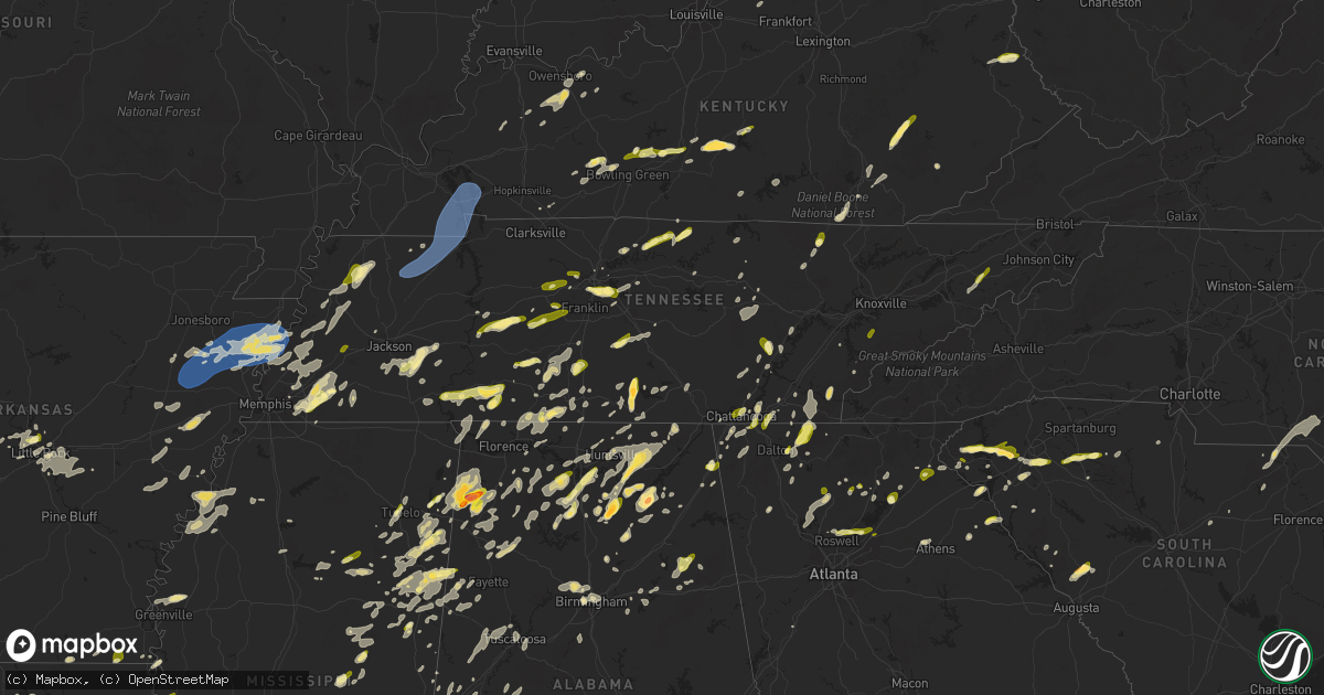
Hail Map in Tennessee on May 2, 2025
Get this storm
May 2 map
$229
one time, instant access
Download today. No call, no setup
Keep the $229
Bought the map and want the full workflow? Apply the entire $229 to a subscription within 7 days. None of it is wasted.
Every map, not just this one
This buys you this map. Subscription and you get every map we run, in the markets you choose from a few cities to whole states to nationwide. Plus real-time alerts the moment a storm fires.
Contact data
Name, contact info, occupancy, even credit band for addresses in the footprint. You go from where it hit to who to call.
Become the source they trust
Unlimited branding weather history reports on demand. You already have the documented answer ready for the property owner, and you are the one who showed up with it.
Property data and RoofTrace estimates
Pull up any address you have got, its value and the exact code rules for that jurisdiction, straight from One Click Code. Then RoofTrace estimates the squares, pitch, and roof value, priced the way you price.
Storm reports in Tennessee
Tennessee
| Date | Description |
|---|---|
| 05/02/20256:50 PM CDT | Trees down and report of hail. Hail size unknown. |
| 05/02/20256:35 PM CDT | Social media photo of trees down in fall branch. |
| 05/02/20256:25 PM CDT | Several trees down and hail reported. Hail size unknown. |
| 05/02/20256:02 PM CDT | Report from mping: quarter |
| 05/02/20256:00 PM CDT | Reported via social media. |
| 05/02/20255:55 PM CDT | Photos of multiple trees down. |
| 05/02/20255:50 PM CDT | Trees down. |
| 05/02/20255:19 PM CDT | Report from mping: quarter |
| 05/02/20255:10 PM CDT | Several trees down. |
| 05/02/20255:00 PM CDT | Multiple trees down. Reported via social media. |
| 05/02/20254:56 PM CDT | Tree reported down at cobb hollow and hurricane creek rd in moore county tn by ema. |
| 05/02/20254:33 PM CDT | Report from mping: quarter |
| 05/02/20254:20 PM CDT | One tree down. |
| 05/02/20253:58 PM CDT | Reports of trees snapped in northern roane county near the rockwood area. Time estimated off radar. |
| 05/02/20253:55 PM CDT | Reports of trees down across the county. Over 1...000 power outages were also observed following the storms. |
| 05/02/20253:50 PM CDT | Corrects previous hail report from maryville for the time. Report via social media. |
| 05/02/20253:50 PM CDT | Several trees down. |
| 05/02/20253:50 PM CDT | Several reports of trees down. This area and near mm 305. |
| 05/02/20253:45 PM CDT | Several trees reported down by ema in the city of dechard tn. |
| 05/02/20253:41 PM CDT | Several trees down by ema in the city of winchester. |
| 05/02/20253:30 PM CDT | Several trees down. Also reports of hail. Unknown size. |
| 05/02/20253:20 PM CDT | Several trees down. |
| 05/02/20253:15 PM CDT | Corrects previous tstm wnd dmg report from 4 wsw vonore. Several trees down. |
| 05/02/20253:15 PM CDT | Several trees down. |
| 05/02/20253:05 PM CDT | Several trees down. |
| 05/02/20253:05 PM CDT | Several trees down and hail. |
| 05/02/20253:00 PM CDT | Several reports of trees down in oneida... Along with some powerlines as well. |
| 05/02/20252:47 PM CDT | Few trees down. |
| 05/02/20252:08 PM CDT | Public report on social media of mainly small hail with some quarter size hail mixed in. |
| 05/02/20251:55 PM CDT | A local report indicates 1.50 inch wind near 3 NNW Lynchburg |
| 05/02/20251:50 PM CDT | Report relayed via social media. |
| 05/02/20251:41 PM CDT | Photo received of quarter size hail reported between unionville and deason. |
| 05/02/20251:40 PM CDT | Tspotter photo received of 1.25 inch hail in nashboro village. |
| 05/02/20251:38 PM CDT | Quarter size hail reported along i-24 near antioch. |
| 05/02/20251:30 PM CDT | A local report indicates 1.00 inch wind near 3 SSW Antioch |
| 05/02/20251:27 PM CDT | Photo of quarter size hail received. |
| 05/02/20251:27 PM CDT | Corrects previous hail report from 3 se berry hill. Photo of quarter size hail received. |
| 05/02/20251:18 PM CDT | Quarter size hail reported just west of lewisburg. |
| 05/02/20251:18 PM CDT | Quarter size hail reported just west of lewisburg. |
| 05/02/20251:18 PM CDT | Photo received of trees down on belmont campus near belmont blvd and ashwood ave. |
| 05/02/20251:05 PM CDT | A local report indicates 1.00 inch wind near Collinwood |
| 05/02/202512:54 PM CDT | Trees down at stephens st. And buffalo rd. |
| 05/02/202512:51 PM CDT | Photo of half-dollar size hail received from minor hill. |
| 05/02/202512:44 PM CDT | A local report indicates 1.00 inch wind near 3 SSW Waynesboro |
| 05/02/202511:55 AM CDT | A local report indicates 1.00 inch wind near Savannah |
| 05/02/202511:24 AM CDT | Trees down reported in land between the lakes. |
| 05/02/202511:00 AM CDT | Uprooted tree fell onto a truck at 1397 state line road west near hazel. |
| 05/02/202511:00 AM CDT | Trees down onto power lines on state line road in hazel. |
| 05/02/202510:50 AM CDT | Trees down at mill creek rd and highway 140. |
| 05/02/202510:48 AM CDT | Several trees down along shady grove rd. |
| 05/02/202510:46 AM CDT | A local report indicates 1.25 inch wind near Jacks Creek |
| 05/02/202510:41 AM CDT | Tree down on vehicle on w blythe st and utility pole down on w wood st. |
| 05/02/202510:40 AM CDT | Multiple trees down on highway 54 at gate 3 rd. |
| 05/02/202510:38 AM CDT | Reported quarter sized hail at chester county high school. |
| 05/02/202510:31 AM CDT | A local report indicates 1.00 inch wind near 1 ESE Henderson |
| 05/02/202510:16 AM CDT | Tree uprooted on seminary road. |
| 05/02/202510:15 AM CDT | Several trees down on presson rd. |
| 05/02/202510:12 AM CDT | Another round of quarter-sized hail. |
| 05/02/20259:56 AM CDT | A local report indicates 1.00 inch wind near 1 SE Oakland |
| 05/02/20259:54 AM CDT | Reported half dollar sized hail in macon... Tn. Exact location was radar estimated. |
| 05/02/20259:46 AM CDT | A local report indicates 1.00 inch wind near 5 SE Eads |
| 05/02/20259:44 AM CDT | A local report indicates 1.00 inch wind near Somerville |
| 05/02/20259:42 AM CDT | Reported quarter sized hail in collierville... Tn. Time was radar estimated. |
| 05/02/20259:41 AM CDT | A local report indicates 1.00 inch wind near Brownsville |
| 05/02/20259:41 AM CDT | Reported quarter size hail in brownsville... Tn. Radar estimated location. |
| 05/02/20259:28 AM CDT | Trees and power lines down. |
| 05/02/20259:03 AM CDT | Numerous trees down in the ripley area. |
| 05/02/20258:40 AM CDT | Four or five trees down along highway 59 near garland. |
| 05/01/20258:56 PM CDT | Report via social media. |
All States Impacted by Hail Map on May 2, 2025
Cities Impacted by Hail Map on May 2, 2025
- Hollister, OK
- Frederick, OK
- Loveland, OK
- Weiner, AR
- Fisher, AR
- Delaware, AR
- New Blaine, AR
- Scranton, AR
- Harrisburg, AR
- Dardanelle, AR
- Knoxville, AR
- Lamar, AR
- Trumann, AR
- Dover, AR
- London, AR
- Arlington, TN
- Wynne, AR
- Cherry Valley, AR
- Parkin, AR
- Marked Tree, AR
- Earle, AR
- Tyronza, AR
- Lepanto, AR
- Caraway, AR
- Eads, TN
- Collierville, TN
- Rossville, TN
- Oakland, TN
- Pelsor, AR
- Palestine, AR
- Cordova, TN
- Clayton, NM
- Texline, TX
- Dalhart, TX
- Sedan, NM
- Grenville, NM
- Forrest City, AR
- Dyess, AR
- Somerville, TN
- Turrell, AR
- Luxora, AR
- Keiser, AR
- Ripley, TN
- Etowah, AR
- Joiner, AR
- Osceola, AR
- Wilson, AR
- Manila, AR
- Henning, TN
- Bassett, AR
- Drummonds, TN
- Frenchmans Bayou, AR
- Casa, AR
- Morrilton, AR
- Madison, AR
- Mason, TN
- Widener, AR
- Covington, TN
- Burlison, TN
- Brighton, TN
- Adona, AR
- Atoka, TN
- Munford, TN
- Millington, TN
- Halls, TN
- Brownsville, TN
- Gates, TN
- Roland, AR
- Little Rock, AR
- Dyersburg, TN
- Newbern, TN
- Maumelle, AR
- Friendship, TN
- Stanton, TN
- North Little Rock, AR
- Germantown, TN
- Trimble, TN
- Kenton, TN
- Trenton, TN
- Dyer, TN
- Williston, TN
- Conway, AR
- Alexander, AR
- Sherwood, AR
- Rives, TN
- Scott, AR
- Paron, AR
- Mayflower, AR
- Sharon, TN
- Henderson, TN
- Whiteville, TN
- Bolivar, TN
- Hickory Valley, TN
- Holly Grove, AR
- Medon, TN
- Jackson, TN
- Clarendon, AR
- De Witt, AR
- Crocketts Bluff, AR
- Ranger, TX
- Pinson, TN
- England, AR
- McCrory, AR
- Cotton Plant, AR
- Palmersville, TN
- Cottage Grove, TN
- Moro, AR
- Brinkley, AR
- Bethel Springs, TN
- Adamsville, TN
- Finger, TN
- Dresden, TN
- Marvell, AR
- Colt, AR
- Beech Bluff, TN
- Keo, AR
- Lonoke, AR
- Poplar Grove, AR
- Alligator, MS
- Crumrod, AR
- Duncan, MS
- Huron, TN
- Jacks Creek, TN
- Luray, TN
- Botkins, OH
- Jackson Center, OH
- Anna, OH
- Lewistown, OH
- Fulton, MS
- Lexa, AR
- Maplewood, OH
- Vina, AL
- Lakeview, OH
- Russells Point, OH
- Clarksdale, MS
- Lexington, TN
- Roswell, GA
- Woodstock, GA
- Huntsville, OH
- Belle Center, OH
- Hodges, AL
- Hamilton, AL
- Hackleburg, AL
- Stantonville, TN
- Selmer, TN
- Strawn, TX
- Red Bay, AL
- Alpharetta, GA
- McKenzie, TN
- Gleason, TN
- Greenfield, TN
- Martin, TN
- Henry, TN
- Puryear, TN
- Paris, TN
- Hazel, KY
- Farmington, KY
- Dukedom, TN
- Murray, KY
- Mayfield, KY
- Buchanan, TN
- Sedalia, KY
- Dexter, KY
- Kirksey, KY
- Benton, KY
- Hardin, KY
- Almo, KY
- Cadiz, KY
- New Concord, KY
- Eddyville, KY
- Grand Rivers, KY
- Kuttawa, KY
- Tiline, KY
- Gilbertsville, KY
- Dover, TN
- Bumpus Mills, TN
- Princeton, KY
- Golden, MS
- Choudrant, LA
- Walhalla, SC
- Cleveland, TX
- Dayton, TX
- Mingus, TX
- Gordon, TX
- Forest, OH
- Lyon, MS
- Downsville, LA
- Rushsylvania, OH
- Bellefontaine, OH
- Spruce Pine, AL
- West Union, SC
- Seneca, SC
- Shelbyville, TX
- Stephenville, TX
- Santo, TX
- Lipan, TX
- Suwanee, GA
- Cumming, GA
- Duluth, GA
- Buford, GA
- Lobelville, TN
- Russellville, AL
- Cherokee, AL
- Shepherd, TX
- Coahoma, MS
- Sledge, MS
- Linden, TN
- Marks, MS
- Sardis, TN
- Reagan, TN
- Quincy, OH
- Crump, TN
- Savannah, TN
- Humble, TX
- Kingwood, TX
- Huffman, TX
- Centerville, TN
- Nunnelly, TN
- Bluff Dale, TX
- Leoma, TN
- Five Points, TN
- Dawsonville, GA
- Kingston, GA
- Upper Sandusky, OH
- Ruston, LA
- Rogersville, AL
- Anderson, AL
- Lexington, AL
- Rome, GA
- Phil Campbell, AL
- Central, SC
- Six Mile, SC
- Olivehill, TN
- Collinwood, TN
- Lutts, TN
- Waynesboro, TN
- Duck River, TN
- Lyles, TN
- Tolar, TX
- Norris, SC
- Acworth, GA
- Canton, GA
- Bellevue, OH
- Willard, OH
- Monroeville, OH
- Hohenwald, TN
- Livingston, TX
- Waleska, GA
- Liberty, SC
- Williamsport, TN
- Primm Springs, TN
- Fairview, TN
- Bon Aqua, TN
- White Bluff, TN
- Burns, TN
- Kingston Springs, TN
- Ashland City, TN
- Pegram, TN
- Summertown, TN
- Goodspring, TN
- Minor Hill, TN
- Memphis, TN
- Norwalk, OH
- Calhoun, LA
- Attica, OH
- Tupelo, MS
- Byhalia, MS
- Collins, OH
- De Graff, OH
- Granbury, TX
- Toccoa, GA
- Saint Joseph, TN
- Loretto, TN
- Killen, AL
- Florence, AL
- Republic, OH
- Ball Ground, GA
- Sidney, OH
- Wakeman, OH
- Easley, SC
- West Monroe, LA
- Nashville, TN
- Santa Fe, TN
- Franklin, TN
- Wilmot, AR
- Parkdale, AR
- Pendleton, SC
- Piedmont, SC
- Cardington, OH
- Cypress Inn, TN
- Hampshire, TN
- Mount Airy, GA
- Eldorado, TX
- Morgantown, KY
- Russellville, KY
- Lewisburg, KY
- Waterloo, AL
- Westminster, SC
- Pulaski, TN
- Lawrenceburg, TN
- Jasper, TX
- Hempstead, TX
- Bowling Green, KY
- Jasper, GA
- Hanson, KY
- Helena, AR
- Prospect, OH
- Marion, OH
- Caledonia, OH
- Edison, OH
- Mount Gilead, OH
- Saltillo, MS
- Independence, OH
- Cleveland, OH
- Maple Heights, OH
- Prospect, TN
- Eros, LA
- Bedford, OH
- Beachwood, OH
- Friars Point, MS
- Houston, TX
- Kountze, TX
- Utica, KY
- Calhoun, KY
- Demorest, GA
- Lynnville, TN
- Mount Hope, AL
- Iron City, TN
- Crosby, TX
- Ethridge, TN
- West Helena, AR
- Christoval, TX
- Goodrich, TX
- Dundee, MS
- Nebo, KY
- Culleoka, TN
- Town Creek, AL
- New Caney, TX
- Eudora, AR
- Livermore, KY
- Okolona, MS
- Auburn, KY
- Rockfield, KY
- Bronson, TX
- Porter, TX
- Scobey, MS
- Tillatoba, MS
- Sacramento, KY
- Sunbury, OH
- Galena, OH
- Croton, OH
- Chagrin Falls, OH
- Solon, OH
- Lagrange, OH
- Oberlin, OH
- Elyria, OH
- Grafton, OH
- Columbia Station, OH
- Brookpark, OH
- Strongsville, OH
- North Ridgeville, OH
- Olmsted Falls, OH
- Berea, OH
- Lewisburg, TN
- Antioch, TN
- Philpot, KY
- Owensboro, KY
- Fredericktown, OH
- Moulton, AL
- Brentwood, TN
- Mount Pleasant, TN
- Columbia, TN
- Pineland, TX
- Gallatin, TN
- Brookshire, TX
- Pelzer, SC
- Brownsville, KY
- Elkmont, AL
- Lester, AL
- White, GA
- Cartersville, GA
- Novelty, OH
- Centerburg, OH
- Salem, SC
- La Vergne, TN
- Monroe, LA
- Blum, TX
- Pontotoc, MS
- Conroe, TX
- Bellville, OH
- Butler, OH
- Tremont, MS
- Stevenson, AL
- Mayersville, MS
- Ridgeway, OH
- Mount Victory, OH
- West Mansfield, OH
- Pioneer, LA
- Shannon, MS
- Hartwell, GA
- Bowersville, GA
- Howard, OH
- Walhonding, OH
- Warsaw, OH
- Kopperl, TX
- Greenville, MS
- Saratoga, TX
- Morgan, TX
- North Royalton, OH
- Broadview Heights, OH
- Spring, TX
- Flintville, TN
- Kelso, TN
- Gambier, OH
- Simpsonville, SC
- Mount Vernon, OH
- Utica, OH
- Glen Allan, MS
- Tell City, IN
- Maben, MS
- Anderson, SC
- Townville, SC
- Salley, SC
- Park City, KY
- Smiths Grove, KY
- Chatsworth, GA
- Almond, NC
- Pope, MS
- Amory, MS
- Hawesville, KY
- Zavalla, TX
- Whitney, TX
- Benoit, MS
- Brecksville, OH
- Northfield, OH
- Saline, LA
- Dalton, GA
- Mulberry, TN
- Castalian Springs, TN
- Hartsville, TN
- Bethpage, TN
- Meridian, TX
- Clifton, TX
- Crenshaw, MS
- Lafayette, TN
- Dixon Springs, TN
- Unionville, TN
- Bell Buckle, TN
- Shelbyville, TN
- Christiana, TN
- Liberty, TX
- Lynchburg, TN
- Winchester, TN
- Roundhill, KY
- Cave City, KY
- Mammoth Cave, KY
- Horse Cave, KY
- Rayville, LA
- Newbury, OH
- Covington, TX
- Burton, OH
- Chardon, OH
- Hillsboro, TX
- Middlefield, OH
- Windsor, OH
- Chesterland, OH
- Huntsburg, OH
- Orwell, OH
- Rome, OH
- Itasca, TX
- Bristow, IN
- Chatham, LA
- Leighton, AL
- Clarkesville, GA
- Cisco, GA
- Manitou, KY
- Smyrna, TN
- Starkville, MS
- Farmerville, LA
- Fordsville, KY
- Reynolds Station, KY
- Starr, SC
- Jonesboro, TX
- Shaw, MS
- Hillsboro, AL
- Valley Mills, TX
- Rio Vista, TX
- Leland, MS
- Danville, OH
- Loudonville, OH
- Perrysville, OH
- Weir, MS
- Ackerman, MS
- Courtland, AL
- Crandall, GA
- Smithville, MS
- Aberdeen, MS
- Mount Juliet, TN
- Columbia, LA
- Courtland, MS
- Macedonia, OH
- Brenham, TX
- Abbott, TX
- China Spring, TX
- Aurora, OH
- Decatur, AL
- Danville, AL
- Trinity, AL
- Devers, TX
- Hankamer, TX
- Piedmont, OH
- Barnesville, OH
- Flushing, OH
- Elberton, GA
- Greensburg, KY
- Hardyville, KY
- Coolville, OH
- Guysville, OH
- Little Hocking, OH
- Vincent, OH
- Red Boiling Springs, TN
- Marengo, OH
- Ashley, OH
- West Point, MS
- Belton, SC
- Leander, TX
- Iva, SC
- Bogart, GA
- Athens, GA
- Ellijay, GA
- Aquilla, TX
- Tishomingo, MS
- Iuka, MS
- Weimar, TX
- Madison, TN
- Bellville, TX
- Chappell Hill, TX
- Cedarbluff, MS
- Houlka, MS
- Gatesville, TX
- Holmesville, OH
- Millersburg, OH
- Fredericksburg, OH
- Saint Clairsville, OH
- Port Washington, OH
- Gnadenhutten, OH
- Uhrichsville, OH
- Dennison, OH
- Bowerston, OH
- Bynum, TX
- Hubbard, TX
- Malone, TX
- Penelope, TX
- Waco, TX
- Sugarcreek, OH
- New Philadelphia, OH
- Stone Creek, OH
- Baltic, OH
- Hartford, KY
- Whitesville, KY
- Gonzales, TX
- Dellrose, TN
- Hamilton, MS
- Elm Mott, TX
- Natchitoches, LA
- Robeline, LA
- Rumsey, KY
- Cornersville, TN
- Rosanky, TX
- Smithville, TX
- Shreve, OH
- Big Prairie, OH
- Chapel Hill, TN
- Montgomery, TX
- Grayson, LA
- Waverly, TN
- Goldonna, LA
- Garrison, TX
- Greenwood Springs, MS
- Gray Court, SC
- Louisville, MS
- Sturgis, MS
- Abbeville, SC
- Hartselle, AL
- Detroit, AL
- Columbus, TX
- Nettleton, MS
- Marble Falls, TX
- Helenwood, TN
- Oneida, TN
- Adena, OH
- Cadiz, OH
- Dillonvale, OH
- Dayton, TN
- Scio, OH
- Evensville, TN
- Sherrodsville, OH
- Fountain Inn, SC
- Woodruff, SC
- Enoree, SC
- West, TX
- Axtell, TX
- Bristolville, OH
- North Bloomfield, OH
- Cortland, OH
- Kinsman, OH
- Farmdale, OH
- Williamsfield, OH
- Jamestown, PA
- Bridgeport, OH
- Martins Ferry, OH
- Rayland, OH
- Jewett, OH
- Pipe Creek, TX
- Bandera, TX
- Junction, TX
- Petersburg, TN
- Epps, LA
- Delano, TN
- Reliance, TN
- Benton, TN
- Lebanon, TN
- Sunbright, TN
- Center, KY
- Caledonia, MS
- Columbus, MS
- Fort Hood, TX
- Brookeland, TX
- Normandy, TN
- Wartrace, TN
- Oglesby, TX
- Flatonia, TX
- La Grange, TX
- Fayetteville, TX
- Canmer, KY
- Dennis, MS
- Hurricane Mills, TN
- Batesville, MS
- Burton, TX
- Fayetteville, TN
- Washington, TX
- Hartstown, PA
- Somerville, AL
- Madison, AL
- Riesel, TX
- New Plymouth, OH
- Falkville, AL
- Nelsonville, OH
- Buchtel, OH
- Glouster, OH
- Millfield, OH
- Mcconnelsville, OH
- Blue Rock, OH
- Campbellsville, KY
- Elk Horn, KY
- Carrollton, OH
- Amsterdam, OH
- Hopedale, OH
- New Ulm, TX
- Yorkville, OH
- Wheeling, WV
- Tiltonsville, OH
- Wellsburg, WV
- Alleyton, TX
- Sulligent, AL
- Vernon, AL
- Bethesda, OH
- Belmont, OH
- Crooksville, OH
- Carlton, GA
- Mart, TX
- McGregor, TX
- Boerne, TX
- Trenton, KY
- Dewy Rose, GA
- Statham, GA
- Copperas Cove, TX
- Kempner, TX
- Comfort, TX
- Menard, TX
- Estill Springs, TN
- Tullahoma, TN
- Crawford, TX
- Gore Springs, MS
- Grenada, MS
- Tellico Plains, TN
- Philadelphia, MS
- Carthage, MS
- Buffalo Valley, TN
- Pleasant Shade, TN
- Harrison, TN
- Chandlersville, OH
- Atlantic, PA
- Greenville, PA
- Adamsville, PA
- Conneaut Lake, PA
- London, TX
- Hadley, PA
- Cochranton, PA
- West Liberty, WV
- Bethany, WV
- Valley Grove, WV
- Buffalo, SC
- Pauline, SC
- Moody, TX
- Eddy, TX
- Troy, TX
- Frost, TX
- Dawson, TX
- Purdon, TX
- Jacksonville, OH
- Trimble, OH
- Carlton, PA
- Meadville, PA
- West Alexander, PA
- Claysville, PA
- Jefferson, OH
- Linesville, PA
- Huntsville, TX
- New Waverly, TX
- Richards, TX
- New Hope, AL
- Huntsville, AL
- Owens Cross Roads, AL
- Clinton, SC
- Cullman, AL
- Ellinger, TX
- Millport, AL
- Frazeysburg, OH
- Andover, OH
- Marlin, TX
- Ooltewah, TN
- Chattanooga, TN
- Mangham, LA
- Steens, MS
- Comer, GA
- West Point, TX
- Lake Providence, LA
- Sondheimer, LA
- Killeen, TX
- Harker Heights, TX
- Nolanville, TX
- Richmond, OH
- Bloomingdale, OH
- Bergholz, OH
- East Springfield, OH
- Pikeville, TN
- Spring City, TN
- Keithville, LA
- Shreveport, LA
- Kosse, TX
- Vinemont, AL
- Cooperstown, PA
- Utica, PA
- Guys Mills, PA
- Avella, PA
- Washington, PA
- Sparta, TN
- Anderson, TX
- Glidden, TX
- Gurley, AL
- Woodville, AL
- Wortham, TX
- Belton, TX
- Harvest, AL
- Muldoon, TX
- Westpoint, TN
- Temple, TX
- Noxapater, MS
- Crawford, MS
- Union, SC
- Thornton, TX
- Groesbeck, TX
- Bossier City, LA
- East Liverpool, OH
- Calhoun City, MS
- Vardaman, MS
- Houston, MS
- Paint Rock, AL
- Shuqualak, MS
- Monteagle, TN
- Decherd, TN
- Tracy City, TN
- Pelham, TN
- Bear Creek, AL
- Bedias, TX
- Trenton, AL
- College Station, TX
- Holly Pond, AL
- Robbins, TN
- Brooksville, MS
- Winfield, AL
- Somerville, TX
- Bellaire, OH
- Big Creek, MS
- Leavenworth, IN
- Ethelsville, AL
- Readyville, TN
- Old Fort, TN
- Richland, TX
- Beechgrove, TN
- Duck Hill, MS
- Burkesville, KY
- Oakhurst, TX
- Baileyton, AL
- Joppa, AL
- Sale Creek, TN
- Bremond, TX
- Giddings, TX
- Lott, TX
- Haleyville, AL
- Little River Academy, TX
- Meadow Lands, PA
- Georgetown, PA
- Midland, PA
- Industry, PA
- Chester, WV
- Mason, TX
- Haughton, LA
- Franklin, TX
- Streetman, TX
- Fairfield, TX
- Canonsburg, PA
- Eighty Four, PA
- Hearne, TX
- Lexington, TX
- Calvert, TX
- Gause, TX
- Caldwell, TX
- Milano, TX
- Cameron, TX
- Venetia, PA
- Princeton, LA
- Marquez, TX
- Bulverde, TX
- Monterey, TN
- McCormick, SC
- Woodland, MS
- Lincoln, TX
- Redwood, MS
- Valley Park, MS
- Elora, TN
- Livingston, AL
- Schulenburg, TX
- Union Grove, AL
- Emelle, AL
- Epes, AL
- Rising Fawn, GA
- Dunlap, TN
- Graysville, TN
- Reform, AL
- Pointblank, TX
- Brownsboro, AL
- Eldridge, AL
- Shubuta, MS
- Bryan, TX
- Nauvoo, AL
- Valhermoso Springs, AL
- Laceys Spring, AL
- Mantee, MS
- Tanner, AL
- Cat Spring, TX
- Arab, AL
- Bergheim, TX
- Finleyville, PA
- Doyline, LA
- Minden, LA
- Rolling Fork, MS
- Crossville, TN
- Toomsuba, MS
- Fredericksburg, TX
- San Antonio, TX
- Eva, AL
- Troy, SC
- Crossett, AR
- Spring Branch, TX
- Guntersville, AL
- Cuba, AL
- Frierson, LA
- Grand Cane, LA
- Ringgold, LA
- Coushatta, LA
- York, AL
- Lynn, AL
- Gordo, AL
- Eutaw, AL
- Gainesville, AL
- Lookout Mountain, GA
- Ledbetter, TX
- Dime Box, TX
- Normangee, TX
- Edgefield, SC
- Kittanning, PA
- Trenton, SC
- Templeton, PA
- Manchester, KY
- Prairie, MS
- Winnfield, LA
- Schertz, TX
- New Braunfels, TX
- Stantonsburg, NC
- Knoxville, AL
- Huntsville, TN
- Harper, TX
- Addison, AL
- Buhl, AL
- Nacogdoches, TX
- Scooba, MS
- Lauderdale, MS
- Taft, TN
- Hamburg, AR
- Bastrop, LA
- Madisonville, TX
- Sextons Creek, KY
- Booneville, KY
- North Zulch, TX
- Dayton, PA
- Smicksburg, PA
- Johnston, SC
- Ricetown, KY
- Grant, AL
- Farmville, NC
- Coker, AL
- Walstonburg, NC
- Hollytree, AL
- Albertville, AL
- Fort McKavett, TX
- Laguna, NM
- Freeport, OH
- Tennessee Colony, TX
- Doss, TX
- Cibolo, TX
- Walnut Grove, MS
- Glenmont, OH
- Marion, TX
- Rochester Mills, PA
- Bath, NY
- Cameron, NY
- Savona, NY
- Campbell, NY
- Painted Post, NY
- Oneonta, AL
- Allons, TN
- Strunk, KY
- Pine Knot, KY
- Williamsburg, KY
- Glasgow, KY
- New Market, AL
- Meridianville, AL
- Mozelle, KY
- Chappell, KY
- Scottsboro, AL
- Langston, AL
- Northport, AL
- Nancy, KY
- Monticello, KY
- Waelder, TX
- Quinton, AL
- Beaver Dams, NY
- Bradford, NY
- Seguin, TX
- Boligee, AL
- Tuscaloosa, AL
- Punxsutawney, PA
- Rossiter, PA
- McQueeney, TX
- Ulysses, KY
- River, KY
- Watkins Glen, NY
- Lowmansville, KY
- Louisa, KY
- Glen Campbell, PA
- Starks, LA
- Merryville, LA
- Evanston, IN
- Saint Meinrad, IN
- Platte City, MO
- Duncanville, AL
- Blountsville, AL
- Forkland, AL
- Tutor Key, KY
- Paintsville, KY
- Adamsville, AL
- Graysville, AL
- Boaz, AL
- Horton, AL
- Altoona, AL
- Porterville, MS
- Marion Center, PA
- Fairfield, AL
- Anahuac, TX
- Winnie, TX
- Cottondale, AL
- Pleasant Grove, AL
- Carthage, NC
- Deweyville, TX
- Call, TX
- Tomahawk, KY
- Inez, KY
- Mahaffey, PA
- Montour Falls, NY
- Millport, NY
- Alpine, NY
- Horseheads, NY
- Odessa, NY
- Del Rio, TX
- Jamestown, OH
- Jeffersonville, OH
- Camden, MS
- Williamston, NC
- Ringgold, GA
- Apison, TN
- McDonald, TN
- Willis, TX
- Double Springs, AL
- Valley Head, AL
- Henagar, AL
- Sweetwater, TN
- Canton, MS
- Parrottsville, TN
- Greeneville, TN
- Pleasureville, KY
- Iola, TX
- Birmingham, AL
- Robersonville, NC
- Sawyerville, AL
- Greensboro, AL
- Pleasant Hill, TN
- Liberty, MS
- Gardendale, AL
- Mount Olive, AL
- Fultondale, AL
- Locust Fork, AL
- Trafford, AL
- Remlap, AL
- Cleveland, TN
- Kansas City, MO
- Stonewall, TX
- Kingsbury, TX
- Guin, AL
- Brilliant, AL
- Leesville, TX
- Cayuta, NY
- Newfield, NY
- La Jose, PA
- Curwensville, PA
- Spencer, NY
- Ithaca, NY
- New Millport, PA
- Olanta, PA
- Grandview, TN
- Washington, WV
- Wittensville, KY
- Stambaugh, KY
- Sitka, KY
- Arley, AL
- Calhoun, GA
- Fairmount, GA
- Blanco, TX
- Kendalia, TX
- Mosheim, TN
- Gray, KY
- Kennedy, AL
- Washington, NC
- Gloster, MS
- Comstock, TX
- Uniontown, AL
- Marion Junction, AL
- Girdler, KY
- Barbourville, KY
- Montevallo, AL
- Alexandria, AL
- Anniston, AL
- Ohatchee, AL
- Vincent, AL
- Catherine, AL
- Chester, SC
- McConnells, SC
- Chillicothe, OH
- Carbon Hill, AL
- Kingston, OH
- Wellington, AL
- Jacksonville, AL
- Ocoee, TN
- Pheba, MS
- Cropwell, AL
- Talladega, AL
- Pell City, AL
- Gadsden, AL
- Trenton, GA
- Ranger, GA
- Jewett, TX
- Sabina, OH
- Circleville, OH
- Gainesville, GA
- Resaca, GA
- Ray, OH
- Chickamauga, GA
- Flintstone, GA
- Harwood, TX
- Shiner, TX
- Moulton, TX
- Macon, MS
- Jamesville, NC
- Canyon Lake, TX
- Singer, LA
- Ashville, AL
- Staffordsville, KY
- Lincoln, AL
- Fischer, TX
- Brackettville, TX
- Winnsboro, LA
- Rockholds, KY
- Marion, AL
- La Fayette, GA
- Corbin, KY
- Splendora, TX
- Rossville, GA
- Center Point, TX
- Piedmont, AL
- Patrick, SC
- Mount Gilead, NC
- Wadesboro, NC
- Lake Charles, LA
- Yoakum, TX
- Hallettsville, TX
- Murphy, NC
- Epworth, GA
- Snow Shoe, PA
- La Vernia, TX
- Murrayville, GA
- Dahlonega, GA
- Estillfork, AL
- Jonesville, LA
- Big Bend, WV
- Cheraw, SC
- Stoutsville, OH
- Amanda, OH
- Laurelville, OH
- Chesterfield, SC
- Westlake, LA
- Hebron, OH
- Frankfort, OH
- Fort Payne, AL
- Eastaboga, AL
- Johnstown, OH
- Rockingham, NC
- Morven, NC
- Troy, NC
- Candor, NC
- Eupora, MS
- Saint Hedwig, TX
- Wallace, SC
- Waverly, OH
- Brasstown, NC
- Nixon, TX
- Aliceville, AL
- Marble, NC
- Stockdale, TX
- Fackler, AL
- Hayesville, NC
- Robbins, NC
- Cleveland, AL
- Guild, TN
- Akron, AL
- Hamlet, NC
- Cordova, NC
- Demopolis, AL
- Lugoff, SC
- Menlo, GA
- Brookside, AL
- Dora, AL
- Soddy Daisy, TN
- Hixson, TN
- Cabot, PA
- Charleston, TN
- Corning, OH
- Malta, OH
- Mendenhall, MS
- Brandon, MS
- Marston, NC
- Hoffman, NC
- Grantsville, WV
- Rocky Mount, NC
- Cost, TX
- Marble Hill, GA
- Pelahatchie, MS
- Creston, WV
- Springville, AL
- Wallisville, TX
- Morton, MS
- Uvalde, TX
- Riverside, AL
- Andrews, NC
- Braxton, MS
- London, KY
- Lily, KY
- Hartsville, SC
- Tarboro, NC
- Battleboro, NC
- Flatgap, KY
- Camden, SC
- Yorktown, TX
- Birchwood, TN
- Mentone, AL
- Grantville, GA
- Newnan, GA
- Forest, MS
- Lake, MS
- Fort Oglethorpe, GA
- Humboldt, TN
- Vonore, TN
- Elizabeth, IN
- Laconia, IN
- Mertens, TX
- Hermitage, TN
- Batesville, TX
- Goliad, TX
- Crystal City, TX
- Dequincy, LA
- Quaker City, OH
- Silver Creek, MS
- Prentiss, MS
- Grants, NM
- Plum Branch, SC
- Pearsall, TX
- D Hanis, TX
- Eagle Pass, TX
- Smithdale, MS
- Baxter, TN
- San Rafael, NM
- Jena, LA
- Cotulla, TX
- Livingston, TN
- El Indio, TX
- Dilley, TX
- Cuero, TX
- Big Wells, TX
- Rickman, TN
- Eminence, KY
- Toney, AL
- Lula, GA
- Cleveland, GA
- Cubero, NM
- Tilden, TX
- Iowa, LA
- Coden, AL
- Crossville, AL
- Fyffe, AL
- Geraldine, AL
- Groveoak, AL
- New Iberia, LA
- Jeanerette, LA
- Collinsville, AL
- Dawson, AL
- Calliham, TX
- Zapata, TX
- Roma, TX
- Guthrie, KY
- Newbern, AL
- Rio Grande City, TX
- Lucedale, MS
- Garciasville, TX
- Santa Elena, TX
- Mission, TX
- Edinburg, TX
- Grulla, TX
- San Juan, TX
- Pharr, TX
- Laredo, TX
- Belvidere, TN
- Huntland, TN
- Cannelton, IN
- Monroe, TN
- Lewisport, KY
- Shelbyville, KY
- Munfordville, KY
- Maryville, TN
- Whiteside, TN
- Saegertown, PA
- Cornelia, GA
- Princeton, AL


