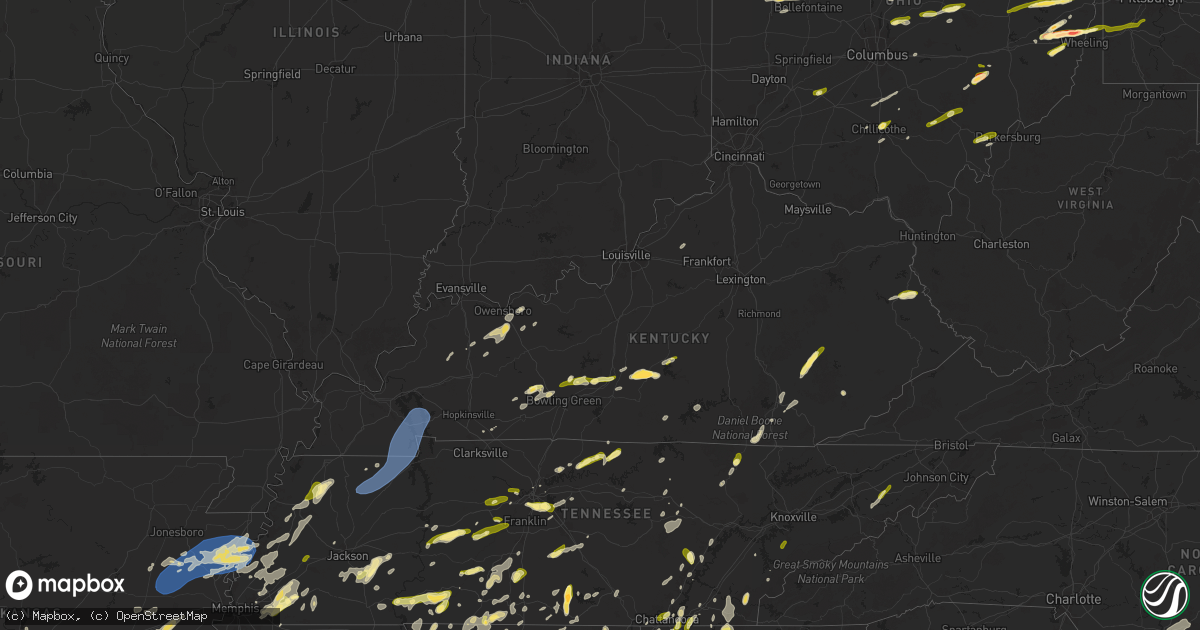
Hail Map in Kentucky on May 2, 2025
Get this storm
May 2 map
$229
one time, instant access
Download today. No call, no setup
Keep the $229
Bought the map and want the full workflow? Apply the entire $229 to a subscription within 7 days. None of it is wasted.
Every map, not just this one
This buys you this map. Subscription and you get every map we run, in the markets you choose from a few cities to whole states to nationwide. Plus real-time alerts the moment a storm fires.
Contact data
Name, contact info, occupancy, even credit band for addresses in the footprint. You go from where it hit to who to call.
Become the source they trust
Unlimited branding weather history reports on demand. You already have the documented answer ready for the property owner, and you are the one who showed up with it.
Property data and RoofTrace estimates
Pull up any address you have got, its value and the exact code rules for that jurisdiction, straight from One Click Code. Then RoofTrace estimates the squares, pitch, and roof value, priced the way you price.
Storm reports in Kentucky
Kentucky
| Date | Description |
|---|---|
| 05/02/20256:30 PM CDT | Lipfird street bridge blocked by large tree. |
| 05/02/20256:30 PM CDT | Tractor trailer reportedly blown over on ky-38 near the marathon gas station. |
| 05/02/20256:15 PM CDT | Corrects previous non-tstm wnd gst report from 1 n keith. Awos station ki35 harlan apt. |
| 05/02/20255:47 PM CDT | Tree reportedly blown down at williams branch. |
| 05/02/20255:47 PM CDT | Tree reported down on old bell high road. |
| 05/02/20255:45 PM CDT | Tree down in front of heidelberg baptist church. |
| 05/02/20255:38 PM CDT | Multiple trees reported down in the arjay area including the 6900 block of ky-66 and around the mose-godsey curve. |
| 05/02/20255:35 PM CDT | Awos station k1a6 middlesboro apt. |
| 05/02/20255:20 PM CDT | Quarter size hail in 1788 us 23 lowmansville... Ky. |
| 05/02/20255:07 PM CDT | Media relayed photos of quarter size hail that occurred in the town of river. Time estimated by radar. |
| 05/02/20254:57 PM CDT | Media relayed photos of quarter sized hail that occurred south of booneville... Near the town of taft. Time estimated by radar. |
| 05/02/20254:29 PM CDT | Tree partially blocking highway near the intersection of mark welborn road and barnesburg road. |
| 05/02/20254:16 PM CDT | Tree blown down and blocking entire highway at around 1000 east frog hollow road. |
| 05/02/20254:11 PM CDT | Powerlines down near the 300 block of anderson heights. |
| 05/02/20254:02 PM CDT | Pulaski county 911 call center reported tree blown down at the intersection of greenwood lane and ky-1248... Blocking half of roadway. |
| 05/02/20253:48 PM CDT | Tree down blocking two lanes of interstate 71 south. |
| 05/02/20253:32 PM CDT | Tree down blocking the road near the 5500 block of highway 146. |
| 05/02/20253:25 PM CDT | Tree down over the road near the 7600 block of rockingham road. |
| 05/02/20253:20 PM CDT | Tree and powerlines down near the 3100 block of lynnwood way. |
| 05/02/20253:14 PM CDT | Tree down across the road at the intersection of lexington road and payne street. |
| 05/02/20253:14 PM CDT | Tree down taking wires with it near the 2100 block of lexington road. |
| 05/02/20253:13 PM CDT | Tree down over the road near the intersection of massie avenue and ridgeway avenue. |
| 05/02/20253:13 PM CDT | Tree down over the 1100 block of etley avenue. |
| 05/02/20253:11 PM CDT | Tree fell on two vehicles at the intersection of east burnett avenue and south brook street. |
| 05/02/20253:10 PM CDT | Tree down across the road near the 600 block of lampton street. |
| 05/02/20253:09 PM CDT | Powerlines down at the intersection of w saint catherine street and south 1st street. |
| 05/02/20253:08 PM CDT | Quarter sized hail reported near the 300 block of capps road. |
| 05/02/20253:07 PM CDT | Tree down taking powerlines with it near the intersection of cypress st and dumesnil street. |
| 05/02/20253:06 PM CDT | Large tree branch fell taking power lines down near the 1500 block of s 32nd street. |
| 05/02/20252:59 PM CDT | Car port blown up into the powerlines on the 10600 block of emma jean way. |
| 05/02/20252:58 PM CDT | Tree and powerlines down on the 6800 block of rutledge road. |
| 05/02/20252:51 PM CDT | Golf ball sized hail reported on facebook. |
| 05/02/20252:38 PM CDT | Corrects previous hail report from 1 ene pierce. Called a local shop in pierce where they reported half dollar sized hail then called back and updated the report with l |
| 05/02/20252:38 PM CDT | Called a local shop in pierce where they reported half dollar sized hail. |
| 05/02/20252:10 PM CDT | Report from mping: quarter |
| 05/02/20252:02 PM CDT | Called a horse farm north of cave city and they reported quarter sized hail and some slightly larger. |
| 05/02/20251:40 PM CDT | Tree down near middle knottsville road and storm road. |
| 05/02/20251:40 PM CDT | Called a gas station in the area and they mentioned that the hail was large... Like the size of an ice cube. |
| 05/02/20251:39 PM CDT | Multiple trees down near joe powers road and state route 2181. |
| 05/02/20251:38 PM CDT | Tree down on the 1100 block of state route 144 east. |
| 05/02/20251:38 PM CDT | Tree down on power line on the 1000 block of state route 114 east. |
| 05/02/20251:22 PM CDT | Report from mping: quarter |
| 05/02/20251:01 PM CDT | Report of quarter sized hail just south of dimple... Ky. |
| 05/02/202512:56 PM CDT | A few trees down along nashville rd. |
| 05/02/202511:13 AM CDT | Large tree down in midway. |
| 05/02/202511:10 AM CDT | Reported on the east side of murray. |
All States Impacted by Hail Map on May 2, 2025
Cities Impacted by Hail Map on May 2, 2025
- Hollister, OK
- Frederick, OK
- Loveland, OK
- Weiner, AR
- Fisher, AR
- Delaware, AR
- New Blaine, AR
- Scranton, AR
- Harrisburg, AR
- Dardanelle, AR
- Knoxville, AR
- Lamar, AR
- Trumann, AR
- Dover, AR
- London, AR
- Arlington, TN
- Wynne, AR
- Cherry Valley, AR
- Parkin, AR
- Marked Tree, AR
- Earle, AR
- Tyronza, AR
- Lepanto, AR
- Caraway, AR
- Eads, TN
- Collierville, TN
- Rossville, TN
- Oakland, TN
- Pelsor, AR
- Palestine, AR
- Cordova, TN
- Clayton, NM
- Texline, TX
- Dalhart, TX
- Sedan, NM
- Grenville, NM
- Forrest City, AR
- Dyess, AR
- Somerville, TN
- Turrell, AR
- Luxora, AR
- Keiser, AR
- Ripley, TN
- Etowah, AR
- Joiner, AR
- Osceola, AR
- Wilson, AR
- Manila, AR
- Henning, TN
- Bassett, AR
- Drummonds, TN
- Frenchmans Bayou, AR
- Casa, AR
- Morrilton, AR
- Madison, AR
- Mason, TN
- Widener, AR
- Covington, TN
- Burlison, TN
- Brighton, TN
- Adona, AR
- Atoka, TN
- Munford, TN
- Millington, TN
- Halls, TN
- Brownsville, TN
- Gates, TN
- Roland, AR
- Little Rock, AR
- Dyersburg, TN
- Newbern, TN
- Maumelle, AR
- Friendship, TN
- Stanton, TN
- North Little Rock, AR
- Germantown, TN
- Trimble, TN
- Kenton, TN
- Trenton, TN
- Dyer, TN
- Williston, TN
- Conway, AR
- Alexander, AR
- Sherwood, AR
- Rives, TN
- Scott, AR
- Paron, AR
- Mayflower, AR
- Sharon, TN
- Henderson, TN
- Whiteville, TN
- Bolivar, TN
- Hickory Valley, TN
- Holly Grove, AR
- Medon, TN
- Jackson, TN
- Clarendon, AR
- De Witt, AR
- Crocketts Bluff, AR
- Ranger, TX
- Pinson, TN
- England, AR
- McCrory, AR
- Cotton Plant, AR
- Palmersville, TN
- Cottage Grove, TN
- Moro, AR
- Brinkley, AR
- Bethel Springs, TN
- Adamsville, TN
- Finger, TN
- Dresden, TN
- Marvell, AR
- Colt, AR
- Beech Bluff, TN
- Keo, AR
- Lonoke, AR
- Poplar Grove, AR
- Alligator, MS
- Crumrod, AR
- Duncan, MS
- Huron, TN
- Jacks Creek, TN
- Luray, TN
- Botkins, OH
- Jackson Center, OH
- Anna, OH
- Lewistown, OH
- Fulton, MS
- Lexa, AR
- Maplewood, OH
- Vina, AL
- Lakeview, OH
- Russells Point, OH
- Clarksdale, MS
- Lexington, TN
- Roswell, GA
- Woodstock, GA
- Huntsville, OH
- Belle Center, OH
- Hodges, AL
- Hamilton, AL
- Hackleburg, AL
- Stantonville, TN
- Selmer, TN
- Strawn, TX
- Red Bay, AL
- Alpharetta, GA
- McKenzie, TN
- Gleason, TN
- Greenfield, TN
- Martin, TN
- Henry, TN
- Puryear, TN
- Paris, TN
- Hazel, KY
- Farmington, KY
- Dukedom, TN
- Murray, KY
- Mayfield, KY
- Buchanan, TN
- Sedalia, KY
- Dexter, KY
- Kirksey, KY
- Benton, KY
- Hardin, KY
- Almo, KY
- Cadiz, KY
- New Concord, KY
- Eddyville, KY
- Grand Rivers, KY
- Kuttawa, KY
- Tiline, KY
- Gilbertsville, KY
- Dover, TN
- Bumpus Mills, TN
- Princeton, KY
- Golden, MS
- Choudrant, LA
- Walhalla, SC
- Cleveland, TX
- Dayton, TX
- Mingus, TX
- Gordon, TX
- Forest, OH
- Lyon, MS
- Downsville, LA
- Rushsylvania, OH
- Bellefontaine, OH
- Spruce Pine, AL
- West Union, SC
- Seneca, SC
- Shelbyville, TX
- Stephenville, TX
- Santo, TX
- Lipan, TX
- Suwanee, GA
- Cumming, GA
- Duluth, GA
- Buford, GA
- Lobelville, TN
- Russellville, AL
- Cherokee, AL
- Shepherd, TX
- Coahoma, MS
- Sledge, MS
- Linden, TN
- Marks, MS
- Sardis, TN
- Reagan, TN
- Quincy, OH
- Crump, TN
- Savannah, TN
- Humble, TX
- Kingwood, TX
- Huffman, TX
- Centerville, TN
- Nunnelly, TN
- Bluff Dale, TX
- Leoma, TN
- Five Points, TN
- Dawsonville, GA
- Kingston, GA
- Upper Sandusky, OH
- Ruston, LA
- Rogersville, AL
- Anderson, AL
- Lexington, AL
- Rome, GA
- Phil Campbell, AL
- Central, SC
- Six Mile, SC
- Olivehill, TN
- Collinwood, TN
- Lutts, TN
- Waynesboro, TN
- Duck River, TN
- Lyles, TN
- Tolar, TX
- Norris, SC
- Acworth, GA
- Canton, GA
- Bellevue, OH
- Willard, OH
- Monroeville, OH
- Hohenwald, TN
- Livingston, TX
- Waleska, GA
- Liberty, SC
- Williamsport, TN
- Primm Springs, TN
- Fairview, TN
- Bon Aqua, TN
- White Bluff, TN
- Burns, TN
- Kingston Springs, TN
- Ashland City, TN
- Pegram, TN
- Summertown, TN
- Goodspring, TN
- Minor Hill, TN
- Memphis, TN
- Norwalk, OH
- Calhoun, LA
- Attica, OH
- Tupelo, MS
- Byhalia, MS
- Collins, OH
- De Graff, OH
- Granbury, TX
- Toccoa, GA
- Saint Joseph, TN
- Loretto, TN
- Killen, AL
- Florence, AL
- Republic, OH
- Ball Ground, GA
- Sidney, OH
- Wakeman, OH
- Easley, SC
- West Monroe, LA
- Nashville, TN
- Santa Fe, TN
- Franklin, TN
- Wilmot, AR
- Parkdale, AR
- Pendleton, SC
- Piedmont, SC
- Cardington, OH
- Cypress Inn, TN
- Hampshire, TN
- Mount Airy, GA
- Eldorado, TX
- Morgantown, KY
- Russellville, KY
- Lewisburg, KY
- Waterloo, AL
- Westminster, SC
- Pulaski, TN
- Lawrenceburg, TN
- Jasper, TX
- Hempstead, TX
- Bowling Green, KY
- Jasper, GA
- Hanson, KY
- Helena, AR
- Prospect, OH
- Marion, OH
- Caledonia, OH
- Edison, OH
- Mount Gilead, OH
- Saltillo, MS
- Independence, OH
- Cleveland, OH
- Maple Heights, OH
- Prospect, TN
- Eros, LA
- Bedford, OH
- Beachwood, OH
- Friars Point, MS
- Houston, TX
- Kountze, TX
- Utica, KY
- Calhoun, KY
- Demorest, GA
- Lynnville, TN
- Mount Hope, AL
- Iron City, TN
- Crosby, TX
- Ethridge, TN
- West Helena, AR
- Christoval, TX
- Goodrich, TX
- Dundee, MS
- Nebo, KY
- Culleoka, TN
- Town Creek, AL
- New Caney, TX
- Eudora, AR
- Livermore, KY
- Okolona, MS
- Auburn, KY
- Rockfield, KY
- Bronson, TX
- Porter, TX
- Scobey, MS
- Tillatoba, MS
- Sacramento, KY
- Sunbury, OH
- Galena, OH
- Croton, OH
- Chagrin Falls, OH
- Solon, OH
- Lagrange, OH
- Oberlin, OH
- Elyria, OH
- Grafton, OH
- Columbia Station, OH
- Brookpark, OH
- Strongsville, OH
- North Ridgeville, OH
- Olmsted Falls, OH
- Berea, OH
- Lewisburg, TN
- Antioch, TN
- Philpot, KY
- Owensboro, KY
- Fredericktown, OH
- Moulton, AL
- Brentwood, TN
- Mount Pleasant, TN
- Columbia, TN
- Pineland, TX
- Gallatin, TN
- Brookshire, TX
- Pelzer, SC
- Brownsville, KY
- Elkmont, AL
- Lester, AL
- White, GA
- Cartersville, GA
- Novelty, OH
- Centerburg, OH
- Salem, SC
- La Vergne, TN
- Monroe, LA
- Blum, TX
- Pontotoc, MS
- Conroe, TX
- Bellville, OH
- Butler, OH
- Tremont, MS
- Stevenson, AL
- Mayersville, MS
- Ridgeway, OH
- Mount Victory, OH
- West Mansfield, OH
- Pioneer, LA
- Shannon, MS
- Hartwell, GA
- Bowersville, GA
- Howard, OH
- Walhonding, OH
- Warsaw, OH
- Kopperl, TX
- Greenville, MS
- Saratoga, TX
- Morgan, TX
- North Royalton, OH
- Broadview Heights, OH
- Spring, TX
- Flintville, TN
- Kelso, TN
- Gambier, OH
- Simpsonville, SC
- Mount Vernon, OH
- Utica, OH
- Glen Allan, MS
- Tell City, IN
- Maben, MS
- Anderson, SC
- Townville, SC
- Salley, SC
- Park City, KY
- Smiths Grove, KY
- Chatsworth, GA
- Almond, NC
- Pope, MS
- Amory, MS
- Hawesville, KY
- Zavalla, TX
- Whitney, TX
- Benoit, MS
- Brecksville, OH
- Northfield, OH
- Saline, LA
- Dalton, GA
- Mulberry, TN
- Castalian Springs, TN
- Hartsville, TN
- Bethpage, TN
- Meridian, TX
- Clifton, TX
- Crenshaw, MS
- Lafayette, TN
- Dixon Springs, TN
- Unionville, TN
- Bell Buckle, TN
- Shelbyville, TN
- Christiana, TN
- Liberty, TX
- Lynchburg, TN
- Winchester, TN
- Roundhill, KY
- Cave City, KY
- Mammoth Cave, KY
- Horse Cave, KY
- Rayville, LA
- Newbury, OH
- Covington, TX
- Burton, OH
- Chardon, OH
- Hillsboro, TX
- Middlefield, OH
- Windsor, OH
- Chesterland, OH
- Huntsburg, OH
- Orwell, OH
- Rome, OH
- Itasca, TX
- Bristow, IN
- Chatham, LA
- Leighton, AL
- Clarkesville, GA
- Cisco, GA
- Manitou, KY
- Smyrna, TN
- Starkville, MS
- Farmerville, LA
- Fordsville, KY
- Reynolds Station, KY
- Starr, SC
- Jonesboro, TX
- Shaw, MS
- Hillsboro, AL
- Valley Mills, TX
- Rio Vista, TX
- Leland, MS
- Danville, OH
- Loudonville, OH
- Perrysville, OH
- Weir, MS
- Ackerman, MS
- Courtland, AL
- Crandall, GA
- Smithville, MS
- Aberdeen, MS
- Mount Juliet, TN
- Columbia, LA
- Courtland, MS
- Macedonia, OH
- Brenham, TX
- Abbott, TX
- China Spring, TX
- Aurora, OH
- Decatur, AL
- Danville, AL
- Trinity, AL
- Devers, TX
- Hankamer, TX
- Piedmont, OH
- Barnesville, OH
- Flushing, OH
- Elberton, GA
- Greensburg, KY
- Hardyville, KY
- Coolville, OH
- Guysville, OH
- Little Hocking, OH
- Vincent, OH
- Red Boiling Springs, TN
- Marengo, OH
- Ashley, OH
- West Point, MS
- Belton, SC
- Leander, TX
- Iva, SC
- Bogart, GA
- Athens, GA
- Ellijay, GA
- Aquilla, TX
- Tishomingo, MS
- Iuka, MS
- Weimar, TX
- Madison, TN
- Bellville, TX
- Chappell Hill, TX
- Cedarbluff, MS
- Houlka, MS
- Gatesville, TX
- Holmesville, OH
- Millersburg, OH
- Fredericksburg, OH
- Saint Clairsville, OH
- Port Washington, OH
- Gnadenhutten, OH
- Uhrichsville, OH
- Dennison, OH
- Bowerston, OH
- Bynum, TX
- Hubbard, TX
- Malone, TX
- Penelope, TX
- Waco, TX
- Sugarcreek, OH
- New Philadelphia, OH
- Stone Creek, OH
- Baltic, OH
- Hartford, KY
- Whitesville, KY
- Gonzales, TX
- Dellrose, TN
- Hamilton, MS
- Elm Mott, TX
- Natchitoches, LA
- Robeline, LA
- Rumsey, KY
- Cornersville, TN
- Rosanky, TX
- Smithville, TX
- Shreve, OH
- Big Prairie, OH
- Chapel Hill, TN
- Montgomery, TX
- Grayson, LA
- Waverly, TN
- Goldonna, LA
- Garrison, TX
- Greenwood Springs, MS
- Gray Court, SC
- Louisville, MS
- Sturgis, MS
- Abbeville, SC
- Hartselle, AL
- Detroit, AL
- Columbus, TX
- Nettleton, MS
- Marble Falls, TX
- Helenwood, TN
- Oneida, TN
- Adena, OH
- Cadiz, OH
- Dillonvale, OH
- Dayton, TN
- Scio, OH
- Evensville, TN
- Sherrodsville, OH
- Fountain Inn, SC
- Woodruff, SC
- Enoree, SC
- West, TX
- Axtell, TX
- Bristolville, OH
- North Bloomfield, OH
- Cortland, OH
- Kinsman, OH
- Farmdale, OH
- Williamsfield, OH
- Jamestown, PA
- Bridgeport, OH
- Martins Ferry, OH
- Rayland, OH
- Jewett, OH
- Pipe Creek, TX
- Bandera, TX
- Junction, TX
- Petersburg, TN
- Epps, LA
- Delano, TN
- Reliance, TN
- Benton, TN
- Lebanon, TN
- Sunbright, TN
- Center, KY
- Caledonia, MS
- Columbus, MS
- Fort Hood, TX
- Brookeland, TX
- Normandy, TN
- Wartrace, TN
- Oglesby, TX
- Flatonia, TX
- La Grange, TX
- Fayetteville, TX
- Canmer, KY
- Dennis, MS
- Hurricane Mills, TN
- Batesville, MS
- Burton, TX
- Fayetteville, TN
- Washington, TX
- Hartstown, PA
- Somerville, AL
- Madison, AL
- Riesel, TX
- New Plymouth, OH
- Falkville, AL
- Nelsonville, OH
- Buchtel, OH
- Glouster, OH
- Millfield, OH
- Mcconnelsville, OH
- Blue Rock, OH
- Campbellsville, KY
- Elk Horn, KY
- Carrollton, OH
- Amsterdam, OH
- Hopedale, OH
- New Ulm, TX
- Yorkville, OH
- Wheeling, WV
- Tiltonsville, OH
- Wellsburg, WV
- Alleyton, TX
- Sulligent, AL
- Vernon, AL
- Bethesda, OH
- Belmont, OH
- Crooksville, OH
- Carlton, GA
- Mart, TX
- McGregor, TX
- Boerne, TX
- Trenton, KY
- Dewy Rose, GA
- Statham, GA
- Copperas Cove, TX
- Kempner, TX
- Comfort, TX
- Menard, TX
- Estill Springs, TN
- Tullahoma, TN
- Crawford, TX
- Gore Springs, MS
- Grenada, MS
- Tellico Plains, TN
- Philadelphia, MS
- Carthage, MS
- Buffalo Valley, TN
- Pleasant Shade, TN
- Harrison, TN
- Chandlersville, OH
- Atlantic, PA
- Greenville, PA
- Adamsville, PA
- Conneaut Lake, PA
- London, TX
- Hadley, PA
- Cochranton, PA
- West Liberty, WV
- Bethany, WV
- Valley Grove, WV
- Buffalo, SC
- Pauline, SC
- Moody, TX
- Eddy, TX
- Troy, TX
- Frost, TX
- Dawson, TX
- Purdon, TX
- Jacksonville, OH
- Trimble, OH
- Carlton, PA
- Meadville, PA
- West Alexander, PA
- Claysville, PA
- Jefferson, OH
- Linesville, PA
- Huntsville, TX
- New Waverly, TX
- Richards, TX
- New Hope, AL
- Huntsville, AL
- Owens Cross Roads, AL
- Clinton, SC
- Cullman, AL
- Ellinger, TX
- Millport, AL
- Frazeysburg, OH
- Andover, OH
- Marlin, TX
- Ooltewah, TN
- Chattanooga, TN
- Mangham, LA
- Steens, MS
- Comer, GA
- West Point, TX
- Lake Providence, LA
- Sondheimer, LA
- Killeen, TX
- Harker Heights, TX
- Nolanville, TX
- Richmond, OH
- Bloomingdale, OH
- Bergholz, OH
- East Springfield, OH
- Pikeville, TN
- Spring City, TN
- Keithville, LA
- Shreveport, LA
- Kosse, TX
- Vinemont, AL
- Cooperstown, PA
- Utica, PA
- Guys Mills, PA
- Avella, PA
- Washington, PA
- Sparta, TN
- Anderson, TX
- Glidden, TX
- Gurley, AL
- Woodville, AL
- Wortham, TX
- Belton, TX
- Harvest, AL
- Muldoon, TX
- Westpoint, TN
- Temple, TX
- Noxapater, MS
- Crawford, MS
- Union, SC
- Thornton, TX
- Groesbeck, TX
- Bossier City, LA
- East Liverpool, OH
- Calhoun City, MS
- Vardaman, MS
- Houston, MS
- Paint Rock, AL
- Shuqualak, MS
- Monteagle, TN
- Decherd, TN
- Tracy City, TN
- Pelham, TN
- Bear Creek, AL
- Bedias, TX
- Trenton, AL
- College Station, TX
- Holly Pond, AL
- Robbins, TN
- Brooksville, MS
- Winfield, AL
- Somerville, TX
- Bellaire, OH
- Big Creek, MS
- Leavenworth, IN
- Ethelsville, AL
- Readyville, TN
- Old Fort, TN
- Richland, TX
- Beechgrove, TN
- Duck Hill, MS
- Burkesville, KY
- Oakhurst, TX
- Baileyton, AL
- Joppa, AL
- Sale Creek, TN
- Bremond, TX
- Giddings, TX
- Lott, TX
- Haleyville, AL
- Little River Academy, TX
- Meadow Lands, PA
- Georgetown, PA
- Midland, PA
- Industry, PA
- Chester, WV
- Mason, TX
- Haughton, LA
- Franklin, TX
- Streetman, TX
- Fairfield, TX
- Canonsburg, PA
- Eighty Four, PA
- Hearne, TX
- Lexington, TX
- Calvert, TX
- Gause, TX
- Caldwell, TX
- Milano, TX
- Cameron, TX
- Venetia, PA
- Princeton, LA
- Marquez, TX
- Bulverde, TX
- Monterey, TN
- McCormick, SC
- Woodland, MS
- Lincoln, TX
- Redwood, MS
- Valley Park, MS
- Elora, TN
- Livingston, AL
- Schulenburg, TX
- Union Grove, AL
- Emelle, AL
- Epes, AL
- Rising Fawn, GA
- Dunlap, TN
- Graysville, TN
- Reform, AL
- Pointblank, TX
- Brownsboro, AL
- Eldridge, AL
- Shubuta, MS
- Bryan, TX
- Nauvoo, AL
- Valhermoso Springs, AL
- Laceys Spring, AL
- Mantee, MS
- Tanner, AL
- Cat Spring, TX
- Arab, AL
- Bergheim, TX
- Finleyville, PA
- Doyline, LA
- Minden, LA
- Rolling Fork, MS
- Crossville, TN
- Toomsuba, MS
- Fredericksburg, TX
- San Antonio, TX
- Eva, AL
- Troy, SC
- Crossett, AR
- Spring Branch, TX
- Guntersville, AL
- Cuba, AL
- Frierson, LA
- Grand Cane, LA
- Ringgold, LA
- Coushatta, LA
- York, AL
- Lynn, AL
- Gordo, AL
- Eutaw, AL
- Gainesville, AL
- Lookout Mountain, GA
- Ledbetter, TX
- Dime Box, TX
- Normangee, TX
- Edgefield, SC
- Kittanning, PA
- Trenton, SC
- Templeton, PA
- Manchester, KY
- Prairie, MS
- Winnfield, LA
- Schertz, TX
- New Braunfels, TX
- Stantonsburg, NC
- Knoxville, AL
- Huntsville, TN
- Harper, TX
- Addison, AL
- Buhl, AL
- Nacogdoches, TX
- Scooba, MS
- Lauderdale, MS
- Taft, TN
- Hamburg, AR
- Bastrop, LA
- Madisonville, TX
- Sextons Creek, KY
- Booneville, KY
- North Zulch, TX
- Dayton, PA
- Smicksburg, PA
- Johnston, SC
- Ricetown, KY
- Grant, AL
- Farmville, NC
- Coker, AL
- Walstonburg, NC
- Hollytree, AL
- Albertville, AL
- Fort McKavett, TX
- Laguna, NM
- Freeport, OH
- Tennessee Colony, TX
- Doss, TX
- Cibolo, TX
- Walnut Grove, MS
- Glenmont, OH
- Marion, TX
- Rochester Mills, PA
- Bath, NY
- Cameron, NY
- Savona, NY
- Campbell, NY
- Painted Post, NY
- Oneonta, AL
- Allons, TN
- Strunk, KY
- Pine Knot, KY
- Williamsburg, KY
- Glasgow, KY
- New Market, AL
- Meridianville, AL
- Mozelle, KY
- Chappell, KY
- Scottsboro, AL
- Langston, AL
- Northport, AL
- Nancy, KY
- Monticello, KY
- Waelder, TX
- Quinton, AL
- Beaver Dams, NY
- Bradford, NY
- Seguin, TX
- Boligee, AL
- Tuscaloosa, AL
- Punxsutawney, PA
- Rossiter, PA
- McQueeney, TX
- Ulysses, KY
- River, KY
- Watkins Glen, NY
- Lowmansville, KY
- Louisa, KY
- Glen Campbell, PA
- Starks, LA
- Merryville, LA
- Evanston, IN
- Saint Meinrad, IN
- Platte City, MO
- Duncanville, AL
- Blountsville, AL
- Forkland, AL
- Tutor Key, KY
- Paintsville, KY
- Adamsville, AL
- Graysville, AL
- Boaz, AL
- Horton, AL
- Altoona, AL
- Porterville, MS
- Marion Center, PA
- Fairfield, AL
- Anahuac, TX
- Winnie, TX
- Cottondale, AL
- Pleasant Grove, AL
- Carthage, NC
- Deweyville, TX
- Call, TX
- Tomahawk, KY
- Inez, KY
- Mahaffey, PA
- Montour Falls, NY
- Millport, NY
- Alpine, NY
- Horseheads, NY
- Odessa, NY
- Del Rio, TX
- Jamestown, OH
- Jeffersonville, OH
- Camden, MS
- Williamston, NC
- Ringgold, GA
- Apison, TN
- McDonald, TN
- Willis, TX
- Double Springs, AL
- Valley Head, AL
- Henagar, AL
- Sweetwater, TN
- Canton, MS
- Parrottsville, TN
- Greeneville, TN
- Pleasureville, KY
- Iola, TX
- Birmingham, AL
- Robersonville, NC
- Sawyerville, AL
- Greensboro, AL
- Pleasant Hill, TN
- Liberty, MS
- Gardendale, AL
- Mount Olive, AL
- Fultondale, AL
- Locust Fork, AL
- Trafford, AL
- Remlap, AL
- Cleveland, TN
- Kansas City, MO
- Stonewall, TX
- Kingsbury, TX
- Guin, AL
- Brilliant, AL
- Leesville, TX
- Cayuta, NY
- Newfield, NY
- La Jose, PA
- Curwensville, PA
- Spencer, NY
- Ithaca, NY
- New Millport, PA
- Olanta, PA
- Grandview, TN
- Washington, WV
- Wittensville, KY
- Stambaugh, KY
- Sitka, KY
- Arley, AL
- Calhoun, GA
- Fairmount, GA
- Blanco, TX
- Kendalia, TX
- Mosheim, TN
- Gray, KY
- Kennedy, AL
- Washington, NC
- Gloster, MS
- Comstock, TX
- Uniontown, AL
- Marion Junction, AL
- Girdler, KY
- Barbourville, KY
- Montevallo, AL
- Alexandria, AL
- Anniston, AL
- Ohatchee, AL
- Vincent, AL
- Catherine, AL
- Chester, SC
- McConnells, SC
- Chillicothe, OH
- Carbon Hill, AL
- Kingston, OH
- Wellington, AL
- Jacksonville, AL
- Ocoee, TN
- Pheba, MS
- Cropwell, AL
- Talladega, AL
- Pell City, AL
- Gadsden, AL
- Trenton, GA
- Ranger, GA
- Jewett, TX
- Sabina, OH
- Circleville, OH
- Gainesville, GA
- Resaca, GA
- Ray, OH
- Chickamauga, GA
- Flintstone, GA
- Harwood, TX
- Shiner, TX
- Moulton, TX
- Macon, MS
- Jamesville, NC
- Canyon Lake, TX
- Singer, LA
- Ashville, AL
- Staffordsville, KY
- Lincoln, AL
- Fischer, TX
- Brackettville, TX
- Winnsboro, LA
- Rockholds, KY
- Marion, AL
- La Fayette, GA
- Corbin, KY
- Splendora, TX
- Rossville, GA
- Center Point, TX
- Piedmont, AL
- Patrick, SC
- Mount Gilead, NC
- Wadesboro, NC
- Lake Charles, LA
- Yoakum, TX
- Hallettsville, TX
- Murphy, NC
- Epworth, GA
- Snow Shoe, PA
- La Vernia, TX
- Murrayville, GA
- Dahlonega, GA
- Estillfork, AL
- Jonesville, LA
- Big Bend, WV
- Cheraw, SC
- Stoutsville, OH
- Amanda, OH
- Laurelville, OH
- Chesterfield, SC
- Westlake, LA
- Hebron, OH
- Frankfort, OH
- Fort Payne, AL
- Eastaboga, AL
- Johnstown, OH
- Rockingham, NC
- Morven, NC
- Troy, NC
- Candor, NC
- Eupora, MS
- Saint Hedwig, TX
- Wallace, SC
- Waverly, OH
- Brasstown, NC
- Nixon, TX
- Aliceville, AL
- Marble, NC
- Stockdale, TX
- Fackler, AL
- Hayesville, NC
- Robbins, NC
- Cleveland, AL
- Guild, TN
- Akron, AL
- Hamlet, NC
- Cordova, NC
- Demopolis, AL
- Lugoff, SC
- Menlo, GA
- Brookside, AL
- Dora, AL
- Soddy Daisy, TN
- Hixson, TN
- Cabot, PA
- Charleston, TN
- Corning, OH
- Malta, OH
- Mendenhall, MS
- Brandon, MS
- Marston, NC
- Hoffman, NC
- Grantsville, WV
- Rocky Mount, NC
- Cost, TX
- Marble Hill, GA
- Pelahatchie, MS
- Creston, WV
- Springville, AL
- Wallisville, TX
- Morton, MS
- Uvalde, TX
- Riverside, AL
- Andrews, NC
- Braxton, MS
- London, KY
- Lily, KY
- Hartsville, SC
- Tarboro, NC
- Battleboro, NC
- Flatgap, KY
- Camden, SC
- Yorktown, TX
- Birchwood, TN
- Mentone, AL
- Grantville, GA
- Newnan, GA
- Forest, MS
- Lake, MS
- Fort Oglethorpe, GA
- Humboldt, TN
- Vonore, TN
- Elizabeth, IN
- Laconia, IN
- Mertens, TX
- Hermitage, TN
- Batesville, TX
- Goliad, TX
- Crystal City, TX
- Dequincy, LA
- Quaker City, OH
- Silver Creek, MS
- Prentiss, MS
- Grants, NM
- Plum Branch, SC
- Pearsall, TX
- D Hanis, TX
- Eagle Pass, TX
- Smithdale, MS
- Baxter, TN
- San Rafael, NM
- Jena, LA
- Cotulla, TX
- Livingston, TN
- El Indio, TX
- Dilley, TX
- Cuero, TX
- Big Wells, TX
- Rickman, TN
- Eminence, KY
- Toney, AL
- Lula, GA
- Cleveland, GA
- Cubero, NM
- Tilden, TX
- Iowa, LA
- Coden, AL
- Crossville, AL
- Fyffe, AL
- Geraldine, AL
- Groveoak, AL
- New Iberia, LA
- Jeanerette, LA
- Collinsville, AL
- Dawson, AL
- Calliham, TX
- Zapata, TX
- Roma, TX
- Guthrie, KY
- Newbern, AL
- Rio Grande City, TX
- Lucedale, MS
- Garciasville, TX
- Santa Elena, TX
- Mission, TX
- Edinburg, TX
- Grulla, TX
- San Juan, TX
- Pharr, TX
- Laredo, TX
- Belvidere, TN
- Huntland, TN
- Cannelton, IN
- Monroe, TN
- Lewisport, KY
- Shelbyville, KY
- Munfordville, KY
- Maryville, TN
- Whiteside, TN
- Saegertown, PA
- Cornelia, GA
- Princeton, AL


