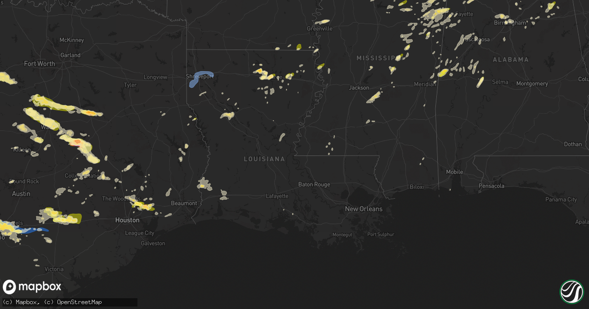
Hail Map in Louisiana on May 2, 2025
Get this storm
May 2 map
$229
one time, instant access
Download today. No call, no setup
Keep the $229
Bought the map and want the full workflow? Apply the entire $229 to a subscription within 7 days. None of it is wasted.
Every map, not just this one
This buys you this map. Subscription and you get every map we run, in the markets you choose from a few cities to whole states to nationwide. Plus real-time alerts the moment a storm fires.
Contact data
Name, contact info, occupancy, even credit band for addresses in the footprint. You go from where it hit to who to call.
Become the source they trust
Unlimited branding weather history reports on demand. You already have the documented answer ready for the property owner, and you are the one who showed up with it.
Property data and RoofTrace estimates
Pull up any address you have got, its value and the exact code rules for that jurisdiction, straight from One Click Code. Then RoofTrace estimates the squares, pitch, and roof value, priced the way you price.
Storm reports in Louisiana
Louisiana
| Date | Description |
|---|---|
| 05/02/20256:30 PM CDT | 911 center reports tree down on the topsy bel rd bridge south of camp pearl rd. Time estimated by radar. |
| 05/02/20256:18 PM CDT | Local official reports a tree down across a roadway near lonnie cole rd and defreize rd. |
| 05/02/20255:42 PM CDT | Utility reports 3 broken powerline crossarms in the oretta area. Time estimated by radar. |
| 05/02/20254:11 PM CDT | Reports of trees down on highway 544 and highway 151 northeast of arcadia. |
| 05/02/20254:11 PM CDT | Reports of multiple trees down along highway 146 on both sides of the highway 563 intersection. |
| 05/02/20254:08 PM CDT | Dispatch report of a tree down on a powerline on choctaw trail. |
| 05/02/20253:44 PM CDT | Dispatch report of a powerline down at intersection of peyton st and hollywood ave. |
| 05/02/20253:38 PM CDT | 64 mph wind gust measured at nws shreveport asos. |
| 05/02/20253:32 PM CDT | Dispatch report of multiple trees down throughout red river parish. |
| 05/02/20253:02 PM CDT | Dispatch reported multiple trees down across the parish... Concentrated on the northern half. |
| 05/02/20252:17 PM CDT | Along scales rd. |
| 05/02/20252:08 PM CDT | Dispatch report of a tree down over a road in florien. |
| 05/02/20251:48 PM CDT | Report of quarter sized hail on tower drive in monroe. |
| 05/02/20251:48 PM CDT | Report of quarter sized hail on tower drive in monroe. |
| 05/02/20251:44 PM CDT | Report of quarter sized hail at the intersection of desiard st and lowery st. |
| 05/02/20251:42 PM CDT | Report of 1.5 in hail near colman ave in west monroe. |
| 05/02/20251:39 PM CDT | Social media post of quarter sized hail by west monroe hs. |
| 05/02/20251:36 PM CDT | Report of quarter sized hail in the monroe garden district. |
| 05/02/20251:36 PM CDT | Report of quarter sized hail on lea joyner bridge in monroe. |
| 05/02/20251:31 PM CDT | Mping report of half dollar size hail. |
| 05/02/20251:10 PM CDT | Report of quarter sized hail at the intersection of new natchitoches rd and hwy 546. |
| 05/02/202511:57 AM CDT | Social media report of large hail... Estimated to be ping pong ball sized... In downsville. |
| 05/01/20258:20 PM CDT | Reported roof damage and a shed tossed into a street between lapalco blvd near belle terre rd and avenue f near patriot street. Possible tornado. Time estimated by rada |
| 05/01/20257:28 PM CDT | 911 center reports tree down on 2nd street in oberlin. |
| 05/01/20257:27 PM CDT | 911 center reports tree limbs and powerlines blown down in southwest oberlin. |
| 05/01/20257:09 PM CDT | 911 center reports pine tree down across hwy 1151 near oberlin. Time estimated by radar. |
All States Impacted by Hail Map on May 2, 2025
Cities Impacted by Hail Map on May 2, 2025
- Hollister, OK
- Frederick, OK
- Loveland, OK
- Weiner, AR
- Fisher, AR
- Delaware, AR
- New Blaine, AR
- Scranton, AR
- Harrisburg, AR
- Dardanelle, AR
- Knoxville, AR
- Lamar, AR
- Trumann, AR
- Dover, AR
- London, AR
- Arlington, TN
- Wynne, AR
- Cherry Valley, AR
- Parkin, AR
- Marked Tree, AR
- Earle, AR
- Tyronza, AR
- Lepanto, AR
- Caraway, AR
- Eads, TN
- Collierville, TN
- Rossville, TN
- Oakland, TN
- Pelsor, AR
- Palestine, AR
- Cordova, TN
- Clayton, NM
- Texline, TX
- Dalhart, TX
- Sedan, NM
- Grenville, NM
- Forrest City, AR
- Dyess, AR
- Somerville, TN
- Turrell, AR
- Luxora, AR
- Keiser, AR
- Ripley, TN
- Etowah, AR
- Joiner, AR
- Osceola, AR
- Wilson, AR
- Manila, AR
- Henning, TN
- Bassett, AR
- Drummonds, TN
- Frenchmans Bayou, AR
- Casa, AR
- Morrilton, AR
- Madison, AR
- Mason, TN
- Widener, AR
- Covington, TN
- Burlison, TN
- Brighton, TN
- Adona, AR
- Atoka, TN
- Munford, TN
- Millington, TN
- Halls, TN
- Brownsville, TN
- Gates, TN
- Roland, AR
- Little Rock, AR
- Dyersburg, TN
- Newbern, TN
- Maumelle, AR
- Friendship, TN
- Stanton, TN
- North Little Rock, AR
- Germantown, TN
- Trimble, TN
- Kenton, TN
- Trenton, TN
- Dyer, TN
- Williston, TN
- Conway, AR
- Alexander, AR
- Sherwood, AR
- Rives, TN
- Scott, AR
- Paron, AR
- Mayflower, AR
- Sharon, TN
- Henderson, TN
- Whiteville, TN
- Bolivar, TN
- Hickory Valley, TN
- Holly Grove, AR
- Medon, TN
- Jackson, TN
- Clarendon, AR
- De Witt, AR
- Crocketts Bluff, AR
- Ranger, TX
- Pinson, TN
- England, AR
- McCrory, AR
- Cotton Plant, AR
- Palmersville, TN
- Cottage Grove, TN
- Moro, AR
- Brinkley, AR
- Bethel Springs, TN
- Adamsville, TN
- Finger, TN
- Dresden, TN
- Marvell, AR
- Colt, AR
- Beech Bluff, TN
- Keo, AR
- Lonoke, AR
- Poplar Grove, AR
- Alligator, MS
- Crumrod, AR
- Duncan, MS
- Huron, TN
- Jacks Creek, TN
- Luray, TN
- Botkins, OH
- Jackson Center, OH
- Anna, OH
- Lewistown, OH
- Fulton, MS
- Lexa, AR
- Maplewood, OH
- Vina, AL
- Lakeview, OH
- Russells Point, OH
- Clarksdale, MS
- Lexington, TN
- Roswell, GA
- Woodstock, GA
- Huntsville, OH
- Belle Center, OH
- Hodges, AL
- Hamilton, AL
- Hackleburg, AL
- Stantonville, TN
- Selmer, TN
- Strawn, TX
- Red Bay, AL
- Alpharetta, GA
- McKenzie, TN
- Gleason, TN
- Greenfield, TN
- Martin, TN
- Henry, TN
- Puryear, TN
- Paris, TN
- Hazel, KY
- Farmington, KY
- Dukedom, TN
- Murray, KY
- Mayfield, KY
- Buchanan, TN
- Sedalia, KY
- Dexter, KY
- Kirksey, KY
- Benton, KY
- Hardin, KY
- Almo, KY
- Cadiz, KY
- New Concord, KY
- Eddyville, KY
- Grand Rivers, KY
- Kuttawa, KY
- Tiline, KY
- Gilbertsville, KY
- Dover, TN
- Bumpus Mills, TN
- Princeton, KY
- Golden, MS
- Choudrant, LA
- Walhalla, SC
- Cleveland, TX
- Dayton, TX
- Mingus, TX
- Gordon, TX
- Forest, OH
- Lyon, MS
- Downsville, LA
- Rushsylvania, OH
- Bellefontaine, OH
- Spruce Pine, AL
- West Union, SC
- Seneca, SC
- Shelbyville, TX
- Stephenville, TX
- Santo, TX
- Lipan, TX
- Suwanee, GA
- Cumming, GA
- Duluth, GA
- Buford, GA
- Lobelville, TN
- Russellville, AL
- Cherokee, AL
- Shepherd, TX
- Coahoma, MS
- Sledge, MS
- Linden, TN
- Marks, MS
- Sardis, TN
- Reagan, TN
- Quincy, OH
- Crump, TN
- Savannah, TN
- Humble, TX
- Kingwood, TX
- Huffman, TX
- Centerville, TN
- Nunnelly, TN
- Bluff Dale, TX
- Leoma, TN
- Five Points, TN
- Dawsonville, GA
- Kingston, GA
- Upper Sandusky, OH
- Ruston, LA
- Rogersville, AL
- Anderson, AL
- Lexington, AL
- Rome, GA
- Phil Campbell, AL
- Central, SC
- Six Mile, SC
- Olivehill, TN
- Collinwood, TN
- Lutts, TN
- Waynesboro, TN
- Duck River, TN
- Lyles, TN
- Tolar, TX
- Norris, SC
- Acworth, GA
- Canton, GA
- Bellevue, OH
- Willard, OH
- Monroeville, OH
- Hohenwald, TN
- Livingston, TX
- Waleska, GA
- Liberty, SC
- Williamsport, TN
- Primm Springs, TN
- Fairview, TN
- Bon Aqua, TN
- White Bluff, TN
- Burns, TN
- Kingston Springs, TN
- Ashland City, TN
- Pegram, TN
- Summertown, TN
- Goodspring, TN
- Minor Hill, TN
- Memphis, TN
- Norwalk, OH
- Calhoun, LA
- Attica, OH
- Tupelo, MS
- Byhalia, MS
- Collins, OH
- De Graff, OH
- Granbury, TX
- Toccoa, GA
- Saint Joseph, TN
- Loretto, TN
- Killen, AL
- Florence, AL
- Republic, OH
- Ball Ground, GA
- Sidney, OH
- Wakeman, OH
- Easley, SC
- West Monroe, LA
- Nashville, TN
- Santa Fe, TN
- Franklin, TN
- Wilmot, AR
- Parkdale, AR
- Pendleton, SC
- Piedmont, SC
- Cardington, OH
- Cypress Inn, TN
- Hampshire, TN
- Mount Airy, GA
- Eldorado, TX
- Morgantown, KY
- Russellville, KY
- Lewisburg, KY
- Waterloo, AL
- Westminster, SC
- Pulaski, TN
- Lawrenceburg, TN
- Jasper, TX
- Hempstead, TX
- Bowling Green, KY
- Jasper, GA
- Hanson, KY
- Helena, AR
- Prospect, OH
- Marion, OH
- Caledonia, OH
- Edison, OH
- Mount Gilead, OH
- Saltillo, MS
- Independence, OH
- Cleveland, OH
- Maple Heights, OH
- Prospect, TN
- Eros, LA
- Bedford, OH
- Beachwood, OH
- Friars Point, MS
- Houston, TX
- Kountze, TX
- Utica, KY
- Calhoun, KY
- Demorest, GA
- Lynnville, TN
- Mount Hope, AL
- Iron City, TN
- Crosby, TX
- Ethridge, TN
- West Helena, AR
- Christoval, TX
- Goodrich, TX
- Dundee, MS
- Nebo, KY
- Culleoka, TN
- Town Creek, AL
- New Caney, TX
- Eudora, AR
- Livermore, KY
- Okolona, MS
- Auburn, KY
- Rockfield, KY
- Bronson, TX
- Porter, TX
- Scobey, MS
- Tillatoba, MS
- Sacramento, KY
- Sunbury, OH
- Galena, OH
- Croton, OH
- Chagrin Falls, OH
- Solon, OH
- Lagrange, OH
- Oberlin, OH
- Elyria, OH
- Grafton, OH
- Columbia Station, OH
- Brookpark, OH
- Strongsville, OH
- North Ridgeville, OH
- Olmsted Falls, OH
- Berea, OH
- Lewisburg, TN
- Antioch, TN
- Philpot, KY
- Owensboro, KY
- Fredericktown, OH
- Moulton, AL
- Brentwood, TN
- Mount Pleasant, TN
- Columbia, TN
- Pineland, TX
- Gallatin, TN
- Brookshire, TX
- Pelzer, SC
- Brownsville, KY
- Elkmont, AL
- Lester, AL
- White, GA
- Cartersville, GA
- Novelty, OH
- Centerburg, OH
- Salem, SC
- La Vergne, TN
- Monroe, LA
- Blum, TX
- Pontotoc, MS
- Conroe, TX
- Bellville, OH
- Butler, OH
- Tremont, MS
- Stevenson, AL
- Mayersville, MS
- Ridgeway, OH
- Mount Victory, OH
- West Mansfield, OH
- Pioneer, LA
- Shannon, MS
- Hartwell, GA
- Bowersville, GA
- Howard, OH
- Walhonding, OH
- Warsaw, OH
- Kopperl, TX
- Greenville, MS
- Saratoga, TX
- Morgan, TX
- North Royalton, OH
- Broadview Heights, OH
- Spring, TX
- Flintville, TN
- Kelso, TN
- Gambier, OH
- Simpsonville, SC
- Mount Vernon, OH
- Utica, OH
- Glen Allan, MS
- Tell City, IN
- Maben, MS
- Anderson, SC
- Townville, SC
- Salley, SC
- Park City, KY
- Smiths Grove, KY
- Chatsworth, GA
- Almond, NC
- Pope, MS
- Amory, MS
- Hawesville, KY
- Zavalla, TX
- Whitney, TX
- Benoit, MS
- Brecksville, OH
- Northfield, OH
- Saline, LA
- Dalton, GA
- Mulberry, TN
- Castalian Springs, TN
- Hartsville, TN
- Bethpage, TN
- Meridian, TX
- Clifton, TX
- Crenshaw, MS
- Lafayette, TN
- Dixon Springs, TN
- Unionville, TN
- Bell Buckle, TN
- Shelbyville, TN
- Christiana, TN
- Liberty, TX
- Lynchburg, TN
- Winchester, TN
- Roundhill, KY
- Cave City, KY
- Mammoth Cave, KY
- Horse Cave, KY
- Rayville, LA
- Newbury, OH
- Covington, TX
- Burton, OH
- Chardon, OH
- Hillsboro, TX
- Middlefield, OH
- Windsor, OH
- Chesterland, OH
- Huntsburg, OH
- Orwell, OH
- Rome, OH
- Itasca, TX
- Bristow, IN
- Chatham, LA
- Leighton, AL
- Clarkesville, GA
- Cisco, GA
- Manitou, KY
- Smyrna, TN
- Starkville, MS
- Farmerville, LA
- Fordsville, KY
- Reynolds Station, KY
- Starr, SC
- Jonesboro, TX
- Shaw, MS
- Hillsboro, AL
- Valley Mills, TX
- Rio Vista, TX
- Leland, MS
- Danville, OH
- Loudonville, OH
- Perrysville, OH
- Weir, MS
- Ackerman, MS
- Courtland, AL
- Crandall, GA
- Smithville, MS
- Aberdeen, MS
- Mount Juliet, TN
- Columbia, LA
- Courtland, MS
- Macedonia, OH
- Brenham, TX
- Abbott, TX
- China Spring, TX
- Aurora, OH
- Decatur, AL
- Danville, AL
- Trinity, AL
- Devers, TX
- Hankamer, TX
- Piedmont, OH
- Barnesville, OH
- Flushing, OH
- Elberton, GA
- Greensburg, KY
- Hardyville, KY
- Coolville, OH
- Guysville, OH
- Little Hocking, OH
- Vincent, OH
- Red Boiling Springs, TN
- Marengo, OH
- Ashley, OH
- West Point, MS
- Belton, SC
- Leander, TX
- Iva, SC
- Bogart, GA
- Athens, GA
- Ellijay, GA
- Aquilla, TX
- Tishomingo, MS
- Iuka, MS
- Weimar, TX
- Madison, TN
- Bellville, TX
- Chappell Hill, TX
- Cedarbluff, MS
- Houlka, MS
- Gatesville, TX
- Holmesville, OH
- Millersburg, OH
- Fredericksburg, OH
- Saint Clairsville, OH
- Port Washington, OH
- Gnadenhutten, OH
- Uhrichsville, OH
- Dennison, OH
- Bowerston, OH
- Bynum, TX
- Hubbard, TX
- Malone, TX
- Penelope, TX
- Waco, TX
- Sugarcreek, OH
- New Philadelphia, OH
- Stone Creek, OH
- Baltic, OH
- Hartford, KY
- Whitesville, KY
- Gonzales, TX
- Dellrose, TN
- Hamilton, MS
- Elm Mott, TX
- Natchitoches, LA
- Robeline, LA
- Rumsey, KY
- Cornersville, TN
- Rosanky, TX
- Smithville, TX
- Shreve, OH
- Big Prairie, OH
- Chapel Hill, TN
- Montgomery, TX
- Grayson, LA
- Waverly, TN
- Goldonna, LA
- Garrison, TX
- Greenwood Springs, MS
- Gray Court, SC
- Louisville, MS
- Sturgis, MS
- Abbeville, SC
- Hartselle, AL
- Detroit, AL
- Columbus, TX
- Nettleton, MS
- Marble Falls, TX
- Helenwood, TN
- Oneida, TN
- Adena, OH
- Cadiz, OH
- Dillonvale, OH
- Dayton, TN
- Scio, OH
- Evensville, TN
- Sherrodsville, OH
- Fountain Inn, SC
- Woodruff, SC
- Enoree, SC
- West, TX
- Axtell, TX
- Bristolville, OH
- North Bloomfield, OH
- Cortland, OH
- Kinsman, OH
- Farmdale, OH
- Williamsfield, OH
- Jamestown, PA
- Bridgeport, OH
- Martins Ferry, OH
- Rayland, OH
- Jewett, OH
- Pipe Creek, TX
- Bandera, TX
- Junction, TX
- Petersburg, TN
- Epps, LA
- Delano, TN
- Reliance, TN
- Benton, TN
- Lebanon, TN
- Sunbright, TN
- Center, KY
- Caledonia, MS
- Columbus, MS
- Fort Hood, TX
- Brookeland, TX
- Normandy, TN
- Wartrace, TN
- Oglesby, TX
- Flatonia, TX
- La Grange, TX
- Fayetteville, TX
- Canmer, KY
- Dennis, MS
- Hurricane Mills, TN
- Batesville, MS
- Burton, TX
- Fayetteville, TN
- Washington, TX
- Hartstown, PA
- Somerville, AL
- Madison, AL
- Riesel, TX
- New Plymouth, OH
- Falkville, AL
- Nelsonville, OH
- Buchtel, OH
- Glouster, OH
- Millfield, OH
- Mcconnelsville, OH
- Blue Rock, OH
- Campbellsville, KY
- Elk Horn, KY
- Carrollton, OH
- Amsterdam, OH
- Hopedale, OH
- New Ulm, TX
- Yorkville, OH
- Wheeling, WV
- Tiltonsville, OH
- Wellsburg, WV
- Alleyton, TX
- Sulligent, AL
- Vernon, AL
- Bethesda, OH
- Belmont, OH
- Crooksville, OH
- Carlton, GA
- Mart, TX
- McGregor, TX
- Boerne, TX
- Trenton, KY
- Dewy Rose, GA
- Statham, GA
- Copperas Cove, TX
- Kempner, TX
- Comfort, TX
- Menard, TX
- Estill Springs, TN
- Tullahoma, TN
- Crawford, TX
- Gore Springs, MS
- Grenada, MS
- Tellico Plains, TN
- Philadelphia, MS
- Carthage, MS
- Buffalo Valley, TN
- Pleasant Shade, TN
- Harrison, TN
- Chandlersville, OH
- Atlantic, PA
- Greenville, PA
- Adamsville, PA
- Conneaut Lake, PA
- London, TX
- Hadley, PA
- Cochranton, PA
- West Liberty, WV
- Bethany, WV
- Valley Grove, WV
- Buffalo, SC
- Pauline, SC
- Moody, TX
- Eddy, TX
- Troy, TX
- Frost, TX
- Dawson, TX
- Purdon, TX
- Jacksonville, OH
- Trimble, OH
- Carlton, PA
- Meadville, PA
- West Alexander, PA
- Claysville, PA
- Jefferson, OH
- Linesville, PA
- Huntsville, TX
- New Waverly, TX
- Richards, TX
- New Hope, AL
- Huntsville, AL
- Owens Cross Roads, AL
- Clinton, SC
- Cullman, AL
- Ellinger, TX
- Millport, AL
- Frazeysburg, OH
- Andover, OH
- Marlin, TX
- Ooltewah, TN
- Chattanooga, TN
- Mangham, LA
- Steens, MS
- Comer, GA
- West Point, TX
- Lake Providence, LA
- Sondheimer, LA
- Killeen, TX
- Harker Heights, TX
- Nolanville, TX
- Richmond, OH
- Bloomingdale, OH
- Bergholz, OH
- East Springfield, OH
- Pikeville, TN
- Spring City, TN
- Keithville, LA
- Shreveport, LA
- Kosse, TX
- Vinemont, AL
- Cooperstown, PA
- Utica, PA
- Guys Mills, PA
- Avella, PA
- Washington, PA
- Sparta, TN
- Anderson, TX
- Glidden, TX
- Gurley, AL
- Woodville, AL
- Wortham, TX
- Belton, TX
- Harvest, AL
- Muldoon, TX
- Westpoint, TN
- Temple, TX
- Noxapater, MS
- Crawford, MS
- Union, SC
- Thornton, TX
- Groesbeck, TX
- Bossier City, LA
- East Liverpool, OH
- Calhoun City, MS
- Vardaman, MS
- Houston, MS
- Paint Rock, AL
- Shuqualak, MS
- Monteagle, TN
- Decherd, TN
- Tracy City, TN
- Pelham, TN
- Bear Creek, AL
- Bedias, TX
- Trenton, AL
- College Station, TX
- Holly Pond, AL
- Robbins, TN
- Brooksville, MS
- Winfield, AL
- Somerville, TX
- Bellaire, OH
- Big Creek, MS
- Leavenworth, IN
- Ethelsville, AL
- Readyville, TN
- Old Fort, TN
- Richland, TX
- Beechgrove, TN
- Duck Hill, MS
- Burkesville, KY
- Oakhurst, TX
- Baileyton, AL
- Joppa, AL
- Sale Creek, TN
- Bremond, TX
- Giddings, TX
- Lott, TX
- Haleyville, AL
- Little River Academy, TX
- Meadow Lands, PA
- Georgetown, PA
- Midland, PA
- Industry, PA
- Chester, WV
- Mason, TX
- Haughton, LA
- Franklin, TX
- Streetman, TX
- Fairfield, TX
- Canonsburg, PA
- Eighty Four, PA
- Hearne, TX
- Lexington, TX
- Calvert, TX
- Gause, TX
- Caldwell, TX
- Milano, TX
- Cameron, TX
- Venetia, PA
- Princeton, LA
- Marquez, TX
- Bulverde, TX
- Monterey, TN
- McCormick, SC
- Woodland, MS
- Lincoln, TX
- Redwood, MS
- Valley Park, MS
- Elora, TN
- Livingston, AL
- Schulenburg, TX
- Union Grove, AL
- Emelle, AL
- Epes, AL
- Rising Fawn, GA
- Dunlap, TN
- Graysville, TN
- Reform, AL
- Pointblank, TX
- Brownsboro, AL
- Eldridge, AL
- Shubuta, MS
- Bryan, TX
- Nauvoo, AL
- Valhermoso Springs, AL
- Laceys Spring, AL
- Mantee, MS
- Tanner, AL
- Cat Spring, TX
- Arab, AL
- Bergheim, TX
- Finleyville, PA
- Doyline, LA
- Minden, LA
- Rolling Fork, MS
- Crossville, TN
- Toomsuba, MS
- Fredericksburg, TX
- San Antonio, TX
- Eva, AL
- Troy, SC
- Crossett, AR
- Spring Branch, TX
- Guntersville, AL
- Cuba, AL
- Frierson, LA
- Grand Cane, LA
- Ringgold, LA
- Coushatta, LA
- York, AL
- Lynn, AL
- Gordo, AL
- Eutaw, AL
- Gainesville, AL
- Lookout Mountain, GA
- Ledbetter, TX
- Dime Box, TX
- Normangee, TX
- Edgefield, SC
- Kittanning, PA
- Trenton, SC
- Templeton, PA
- Manchester, KY
- Prairie, MS
- Winnfield, LA
- Schertz, TX
- New Braunfels, TX
- Stantonsburg, NC
- Knoxville, AL
- Huntsville, TN
- Harper, TX
- Addison, AL
- Buhl, AL
- Nacogdoches, TX
- Scooba, MS
- Lauderdale, MS
- Taft, TN
- Hamburg, AR
- Bastrop, LA
- Madisonville, TX
- Sextons Creek, KY
- Booneville, KY
- North Zulch, TX
- Dayton, PA
- Smicksburg, PA
- Johnston, SC
- Ricetown, KY
- Grant, AL
- Farmville, NC
- Coker, AL
- Walstonburg, NC
- Hollytree, AL
- Albertville, AL
- Fort McKavett, TX
- Laguna, NM
- Freeport, OH
- Tennessee Colony, TX
- Doss, TX
- Cibolo, TX
- Walnut Grove, MS
- Glenmont, OH
- Marion, TX
- Rochester Mills, PA
- Bath, NY
- Cameron, NY
- Savona, NY
- Campbell, NY
- Painted Post, NY
- Oneonta, AL
- Allons, TN
- Strunk, KY
- Pine Knot, KY
- Williamsburg, KY
- Glasgow, KY
- New Market, AL
- Meridianville, AL
- Mozelle, KY
- Chappell, KY
- Scottsboro, AL
- Langston, AL
- Northport, AL
- Nancy, KY
- Monticello, KY
- Waelder, TX
- Quinton, AL
- Beaver Dams, NY
- Bradford, NY
- Seguin, TX
- Boligee, AL
- Tuscaloosa, AL
- Punxsutawney, PA
- Rossiter, PA
- McQueeney, TX
- Ulysses, KY
- River, KY
- Watkins Glen, NY
- Lowmansville, KY
- Louisa, KY
- Glen Campbell, PA
- Starks, LA
- Merryville, LA
- Evanston, IN
- Saint Meinrad, IN
- Platte City, MO
- Duncanville, AL
- Blountsville, AL
- Forkland, AL
- Tutor Key, KY
- Paintsville, KY
- Adamsville, AL
- Graysville, AL
- Boaz, AL
- Horton, AL
- Altoona, AL
- Porterville, MS
- Marion Center, PA
- Fairfield, AL
- Anahuac, TX
- Winnie, TX
- Cottondale, AL
- Pleasant Grove, AL
- Carthage, NC
- Deweyville, TX
- Call, TX
- Tomahawk, KY
- Inez, KY
- Mahaffey, PA
- Montour Falls, NY
- Millport, NY
- Alpine, NY
- Horseheads, NY
- Odessa, NY
- Del Rio, TX
- Jamestown, OH
- Jeffersonville, OH
- Camden, MS
- Williamston, NC
- Ringgold, GA
- Apison, TN
- McDonald, TN
- Willis, TX
- Double Springs, AL
- Valley Head, AL
- Henagar, AL
- Sweetwater, TN
- Canton, MS
- Parrottsville, TN
- Greeneville, TN
- Pleasureville, KY
- Iola, TX
- Birmingham, AL
- Robersonville, NC
- Sawyerville, AL
- Greensboro, AL
- Pleasant Hill, TN
- Liberty, MS
- Gardendale, AL
- Mount Olive, AL
- Fultondale, AL
- Locust Fork, AL
- Trafford, AL
- Remlap, AL
- Cleveland, TN
- Kansas City, MO
- Stonewall, TX
- Kingsbury, TX
- Guin, AL
- Brilliant, AL
- Leesville, TX
- Cayuta, NY
- Newfield, NY
- La Jose, PA
- Curwensville, PA
- Spencer, NY
- Ithaca, NY
- New Millport, PA
- Olanta, PA
- Grandview, TN
- Washington, WV
- Wittensville, KY
- Stambaugh, KY
- Sitka, KY
- Arley, AL
- Calhoun, GA
- Fairmount, GA
- Blanco, TX
- Kendalia, TX
- Mosheim, TN
- Gray, KY
- Kennedy, AL
- Washington, NC
- Gloster, MS
- Comstock, TX
- Uniontown, AL
- Marion Junction, AL
- Girdler, KY
- Barbourville, KY
- Montevallo, AL
- Alexandria, AL
- Anniston, AL
- Ohatchee, AL
- Vincent, AL
- Catherine, AL
- Chester, SC
- McConnells, SC
- Chillicothe, OH
- Carbon Hill, AL
- Kingston, OH
- Wellington, AL
- Jacksonville, AL
- Ocoee, TN
- Pheba, MS
- Cropwell, AL
- Talladega, AL
- Pell City, AL
- Gadsden, AL
- Trenton, GA
- Ranger, GA
- Jewett, TX
- Sabina, OH
- Circleville, OH
- Gainesville, GA
- Resaca, GA
- Ray, OH
- Chickamauga, GA
- Flintstone, GA
- Harwood, TX
- Shiner, TX
- Moulton, TX
- Macon, MS
- Jamesville, NC
- Canyon Lake, TX
- Singer, LA
- Ashville, AL
- Staffordsville, KY
- Lincoln, AL
- Fischer, TX
- Brackettville, TX
- Winnsboro, LA
- Rockholds, KY
- Marion, AL
- La Fayette, GA
- Corbin, KY
- Splendora, TX
- Rossville, GA
- Center Point, TX
- Piedmont, AL
- Patrick, SC
- Mount Gilead, NC
- Wadesboro, NC
- Lake Charles, LA
- Yoakum, TX
- Hallettsville, TX
- Murphy, NC
- Epworth, GA
- Snow Shoe, PA
- La Vernia, TX
- Murrayville, GA
- Dahlonega, GA
- Estillfork, AL
- Jonesville, LA
- Big Bend, WV
- Cheraw, SC
- Stoutsville, OH
- Amanda, OH
- Laurelville, OH
- Chesterfield, SC
- Westlake, LA
- Hebron, OH
- Frankfort, OH
- Fort Payne, AL
- Eastaboga, AL
- Johnstown, OH
- Rockingham, NC
- Morven, NC
- Troy, NC
- Candor, NC
- Eupora, MS
- Saint Hedwig, TX
- Wallace, SC
- Waverly, OH
- Brasstown, NC
- Nixon, TX
- Aliceville, AL
- Marble, NC
- Stockdale, TX
- Fackler, AL
- Hayesville, NC
- Robbins, NC
- Cleveland, AL
- Guild, TN
- Akron, AL
- Hamlet, NC
- Cordova, NC
- Demopolis, AL
- Lugoff, SC
- Menlo, GA
- Brookside, AL
- Dora, AL
- Soddy Daisy, TN
- Hixson, TN
- Cabot, PA
- Charleston, TN
- Corning, OH
- Malta, OH
- Mendenhall, MS
- Brandon, MS
- Marston, NC
- Hoffman, NC
- Grantsville, WV
- Rocky Mount, NC
- Cost, TX
- Marble Hill, GA
- Pelahatchie, MS
- Creston, WV
- Springville, AL
- Wallisville, TX
- Morton, MS
- Uvalde, TX
- Riverside, AL
- Andrews, NC
- Braxton, MS
- London, KY
- Lily, KY
- Hartsville, SC
- Tarboro, NC
- Battleboro, NC
- Flatgap, KY
- Camden, SC
- Yorktown, TX
- Birchwood, TN
- Mentone, AL
- Grantville, GA
- Newnan, GA
- Forest, MS
- Lake, MS
- Fort Oglethorpe, GA
- Humboldt, TN
- Vonore, TN
- Elizabeth, IN
- Laconia, IN
- Mertens, TX
- Hermitage, TN
- Batesville, TX
- Goliad, TX
- Crystal City, TX
- Dequincy, LA
- Quaker City, OH
- Silver Creek, MS
- Prentiss, MS
- Grants, NM
- Plum Branch, SC
- Pearsall, TX
- D Hanis, TX
- Eagle Pass, TX
- Smithdale, MS
- Baxter, TN
- San Rafael, NM
- Jena, LA
- Cotulla, TX
- Livingston, TN
- El Indio, TX
- Dilley, TX
- Cuero, TX
- Big Wells, TX
- Rickman, TN
- Eminence, KY
- Toney, AL
- Lula, GA
- Cleveland, GA
- Cubero, NM
- Tilden, TX
- Iowa, LA
- Coden, AL
- Crossville, AL
- Fyffe, AL
- Geraldine, AL
- Groveoak, AL
- New Iberia, LA
- Jeanerette, LA
- Collinsville, AL
- Dawson, AL
- Calliham, TX
- Zapata, TX
- Roma, TX
- Guthrie, KY
- Newbern, AL
- Rio Grande City, TX
- Lucedale, MS
- Garciasville, TX
- Santa Elena, TX
- Mission, TX
- Edinburg, TX
- Grulla, TX
- San Juan, TX
- Pharr, TX
- Laredo, TX
- Belvidere, TN
- Huntland, TN
- Cannelton, IN
- Monroe, TN
- Lewisport, KY
- Shelbyville, KY
- Munfordville, KY
- Maryville, TN
- Whiteside, TN
- Saegertown, PA
- Cornelia, GA
- Princeton, AL


