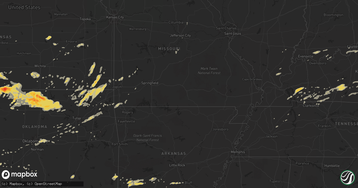
Hail Map on April 30, 2012
Get this storm
April 30 map
$229
one time, instant access
Download today. No call, no setup
Keep the $229
Bought the map and want the full workflow? Apply the entire $229 to a subscription within 7 days. None of it is wasted.
Every map, not just this one
This buys you this map. Subscription and you get every map we run, in the markets you choose from a few cities to whole states to nationwide. Plus real-time alerts the moment a storm fires.
Contact data
Name, contact info, occupancy, even credit band for addresses in the footprint. You go from where it hit to who to call.
Become the source they trust
Unlimited branding weather history reports on demand. You already have the documented answer ready for the property owner, and you are the one who showed up with it.
Property data and RoofTrace estimates
Pull up any address you have got, its value and the exact code rules for that jurisdiction, straight from One Click Code. Then RoofTrace estimates the squares, pitch, and roof value, priced the way you price.
States Impacted by Hail Map on April 30, 2012
Storm reports
Indiana
| Date | Description |
|---|---|
| 04/30/20126:30 PM CDT | Large tree limb down across sim hodgin parkway |
| 04/30/20125:29 PM CDT | Tree down |
| 04/30/20125:00 PM CDT | Slighty larger than quarter sized |
| 04/30/20124:53 PM CDT | Relayed by huntington county em |
| 04/30/20124:51 PM CDT | Binford and emmerson way... Estimated 30ft tall healthy pine tree uprooted and blown over. |
| 04/30/20124:39 PM CDT | Tree down across road at first and nancy |
| 04/30/20124:34 PM CDT | 56th and binford.... 3-4 inch diameter tree branch down |
Tennessee
| Date | Description |
|---|---|
| 04/30/20124:15 PM CDT | A local report indicates 1.00 inch wind near 4 S ROAN MOUNTAIN |
Missouri
| Date | Description |
|---|---|
| 04/30/20123:18 AM CDT | A local report indicates 60 MPH wind near 1 W REPUBLIC |
| 04/30/20123:14 AM CDT | A local report indicates 60 MPH wind near WNW AURORA |
Oklahoma
| Date | Description |
|---|---|
| 04/30/20123:35 AM CDT | 2 to 3 inch diameter tree limbs down on highway 59 |
| 04/30/20121:53 AM CDT | Large tree limbs down. Shingles damaged on numerous homes. |
| 04/30/20121:45 AM CDT | A local report indicates 58 MPH wind near 3 SSE INOLA |
| 04/30/20121:35 AM CDT | Large tree limbs blown down and brought down power lines. |
| 04/30/20121:34 AM CDT | Power lines and trees over a foot in diameter down south of dawes. |
| 04/30/20121:30 AM CDT | Ef1 damage was confirmed on the north side of welch. Two homes were damaged...one with the roof completely off the home. Surveyors noted mud and debris caked on the eas |
| 04/30/20121:30 AM CDT | Vinita mesonet. |
| 04/30/20121:30 AM CDT | Several homes lost shingles. Large tree limbs broken and downed. |
| 04/30/20121:30 AM CDT | Centralia mesonet. |
| 04/30/20121:21 AM CDT | A local report indicates 65 MPH wind near 2 ENE BROKEN ARROW |
| 04/30/20121:11 AM CDT | Large tree down blocking road near centralia. Time estimated by radar. |
| 04/30/201212:58 AM CDT | Out building damaged...moved 10-15 feet off foundation. 6 to 8 inch diameter tree blown over. Report relayed via emergency mgt. |
| 04/30/201212:55 AM CDT | Tree on top of house on cherokee street in delaware. Time estimated by radar. |
| 04/30/201212:42 AM CDT | Damage survey found 6.5 mile long tornado path of numerous snapped and uprooted hardwood trees and several damaged barns. Tornado was rated ef1 with maximum wind of 105 |
| 04/30/201212:33 AM CDT | Power lines down near the interstate 40 and 240 interchange. Reported by okc fire dispatch. |
| 04/30/201212:25 AM CDT | Large tree limbs down |
| 04/30/201212:10 AM CDT | Oklahoma mesonet. |
| 04/30/201212:06 AM CDT | Several large tree limbs down. Time estimated by radar. |
| 04/30/201212:00 AM CDT | A local report indicates 1.00 inch wind near HARRAH |
| 04/30/201212:00 AM CDT | 3ft diamter tree blown over |
| 04/29/201211:52 PM CDT | A local report indicates 1.00 inch wind near CHOCTAW |
| 04/29/201211:40 PM CDT | Reports of large tree limbs broken around town. |
| 04/29/201211:33 PM CDT | A local report indicates 62 MPH wind near WILL ROGERS AIRPORT |
| 04/29/201211:30 PM CDT | A local report indicates 65 MPH wind near 2 SSW MINCO |
| 04/29/201211:25 PM CDT | A local report indicates 78 MPH wind near 2 SSW MINCO |
| 04/29/201211:19 PM CDT | Several large tree limbs down |
| 04/29/201210:45 PM CDT | Roof and outbuilding damage 4se of hwy11/i35. Time estimated. |
| 04/29/201210:35 PM CDT | A local report indicates 60 MPH wind near 5 WNW EL RENO |
| 04/29/201210:30 PM CDT | Several power poles blown down |
| 04/29/201210:30 PM CDT | A local report indicates 1.00 inch wind near HOLLIS |
| 04/29/201210:30 PM CDT | A local report indicates 60 MPH wind near 4 NNW FORT COBB |
| 04/29/201210:25 PM CDT | A local report indicates 64 MPH wind near 4 NNW FORT COBB |
| 04/29/201210:10 PM CDT | A local report indicates 76 MPH wind near 3 W GOULD |
| 04/29/201210:10 PM CDT | A local report indicates 1.50 inch wind near 3 E HOLLIS |
| 04/29/201210:05 PM CDT | Large trees uprooted |
| 04/29/201210:00 PM CDT | A local report indicates 65 MPH wind near 1 SW MEDFORD |
| 04/29/20129:58 PM CDT | A local report indicates 1.00 inch wind near HOLLIS |
| 04/29/20129:55 PM CDT | A local report indicates 67 MPH wind near 1 SW MEDFORD |
| 04/29/20129:50 PM CDT | A local report indicates 68 MPH wind near 1 SW MEDFORD |
| 04/29/20129:45 PM CDT | A local report indicates 1.75 inch wind near 5 SSW VINSON |
| 04/29/20129:35 PM CDT | A local report indicates 1.75 inch wind near 5 SSW VINSON |
| 04/29/20129:30 PM CDT | A local report indicates 65 MPH wind near 1 SW MEDFORD |
| 04/29/20129:15 PM CDT | A local report indicates 58 MPH wind near 1 SW MEDFORD |
| 04/29/20129:10 PM CDT | The wind gust occurred as a likely tornado moved south of the site. |
| 04/29/20129:06 PM CDT | A local report indicates a tornado near 2 SW MEDFORD |
| 04/29/20129:01 PM CDT | This tornado developed southwest of medford and moved northeast. The mesonet site 1 mile southwest of medford reported a wind gust of 84 mph at 2110 cdt. The tornado li |
| 04/29/20128:59 PM CDT | Damage survey found 1.5 mile long tornado damage path of a few snapped hardwood tree trunks...numerous snapped branches...and a damaged pole barn. Tornado was rated ef1 |
| 04/29/20128:35 PM CDT | A local report indicates 1.75 inch wind near 7 NW CAPRON |
| 04/29/20128:25 PM CDT | Spotter reported a small tornado touchdown...with a few power flashes |
| 04/29/20128:15 PM CDT | W410 rd and n24 rd. Several brief touchdowns. |
| 04/29/20128:10 PM CDT | Spotter reported a brief tornado touchdown. |
| 04/29/20128:10 PM CDT | Local broadcast media and a storm chaser observed a tornado that began about 4 miles north-northwest of nash. It is somewhat uncertain at this time whether this was a s |
| 04/29/20127:55 PM CDT | Home damage near the intersection of 4060 rd and 2400 rd sw of nowata. Possible tornado damage. Time estimated by radar. |
| 04/29/20127:55 PM CDT | A local report indicates 1.75 inch wind near GREAT SALT PLAINS LAKE |
| 04/29/20127:48 PM CDT | 8 inch tree limb down. |
| 04/29/20127:48 PM CDT | Between quarter and golf ball size hail. |
| 04/29/20127:40 PM CDT | Kfor-tv and alfalfa county emergency manager reported a tornado that formed on the south side of the great salt plains lake. The tornado damaged an outbuilding on the s |
| 04/29/20127:30 PM CDT | Kfor-tv storm chaser reported a brief tornado 2 miles west of nash. No damage was reported with the tornado. |
| 04/29/20127:00 PM CDT | A local report indicates 1.75 inch wind near 12 W ALVA |
Texas
| Date | Description |
|---|---|
| 04/30/20126:58 PM CDT | A local report indicates 1.75 inch wind near CLARENDON |
| 04/30/20126:58 PM CDT | With 0.21 inches of rain |
| 04/30/20126:55 PM CDT | A local report indicates 1.50 inch wind near 4 S CLARENDON |
| 04/30/20126:55 PM CDT | A local report indicates 1.75 inch wind near 5 S CLARENDON |
| 04/30/20126:54 PM CDT | A local report indicates 1.00 inch wind near 3 SE CLAUDE |
| 04/30/20126:54 PM CDT | Along u 82 |
| 04/30/20126:53 PM CDT | Multiple large hailstones still on ground |
| 04/30/20126:52 PM CDT | A local report indicates 1.75 inch wind near 2 S DICKENS |
| 04/30/20126:50 PM CDT | A local report indicates 2.50 inch wind near FLUVANNA |
| 04/30/20126:49 PM CDT | A local report indicates 1.75 inch wind near CLARENDON |
| 04/30/20126:48 PM CDT | Quarter to half dollar size hail reported. |
| 04/30/20126:46 PM CDT | A local report indicates 1.00 inch wind near 2 N HOWARDWICK |
| 04/30/20126:41 PM CDT | A local report indicates 2.75 inch wind near 6 S FLUVANNA |
| 04/30/20126:41 PM CDT | A local report indicates 1.50 inch wind near CLAUDE |
| 04/30/20126:38 PM CDT | A local report indicates 1.75 inch wind near CLAUDE |
| 04/30/20126:36 PM CDT | A local report indicates 1.75 inch wind near 2 W CLAUDE |
| 04/30/20126:35 PM CDT | A local report indicates 1.25 inch wind near 3 SE CLAUDE |
| 04/30/20126:34 PM CDT | A local report indicates 1.50 inch wind near CLAUDE |
| 04/30/20126:32 PM CDT | On us 70 |
| 04/30/20126:28 PM CDT | Relayed by kcbd...along highway 70 in matador. |
| 04/30/20126:23 PM CDT | Reported by matador fire department. |
| 04/30/20126:20 PM CDT | A local report indicates 1.00 inch wind near LAKE MCCLELLAN |
| 04/30/20126:13 PM CDT | Reported by roaring springs fire department. |
| 04/30/20126:05 PM CDT | A local report indicates 1.00 inch wind near FLUVANNA |
| 04/30/20125:55 PM CDT | A local report indicates 1.75 inch wind near 5 SSW AMARILLO |
| 04/30/20125:45 PM CDT | Reported 10 miles north of polar community. |
| 04/30/20125:45 PM CDT | A local report indicates 1.00 inch wind near MCADOO |
| 04/30/20125:45 PM CDT | A local report indicates 1.50 inch wind near 5 S AMARILLO |
| 04/30/20125:35 PM CDT | A local report indicates 1.00 inch wind near 6 WSW AMARILLO |
| 04/30/20125:35 PM CDT | A local report indicates 1.25 inch wind near 10 SW AMARILLO |
| 04/30/20125:33 PM CDT | A local report indicates 1.00 inch wind near 6 SW AMARILLO |
| 04/30/20125:29 PM CDT | A local report indicates 1.00 inch wind near 10 SW AMARILLO |
| 04/30/20125:27 PM CDT | Relayed by kcbd...along crosby garza county line. |
| 04/30/20125:26 PM CDT | A local report indicates 1.50 inch wind near 7 SW AMARILLO |
| 04/30/20125:25 PM CDT | A local report indicates 1.00 inch wind near AMARILLO |
| 04/30/20125:24 PM CDT | A local report indicates 1.00 inch wind near 6 SW AMARILLO |
| 04/30/20125:21 PM CDT | A local report indicates 1.00 inch wind near 6 SW AMARILLO |
| 04/30/20125:11 PM CDT | Half mile wide swath of hail at highway 380 and 208. Largest hail measured at 2 inches. |
| 04/30/20124:45 PM CDT | Windshield broken out by hail on 207 north of post. |
| 04/29/201211:05 PM CDT | A local report indicates 70 MPH wind near 3 NW SEYMOUR |
| 04/29/201210:00 PM CDT | Mostly nickel to quarter size |
| 04/29/201210:00 PM CDT | Roof damage at knox city hospital. Trampolines hanging from power lines. Numerous power outages. Reported by knox county 911. |
| 04/29/20129:31 PM CDT | A local report indicates 1.00 inch wind near MEMPHIS |
| 04/29/20129:00 PM CDT | A local report indicates 1.75 inch wind near LELIA LAKE |
| 04/29/20128:50 PM CDT | Some street flooding reported as well |
| 04/29/20128:50 PM CDT | A local report indicates 60 MPH wind near WELLINGTON |
| 04/29/20128:49 PM CDT | A local report indicates 1.75 inch wind near WELLINGTON |
| 04/29/20128:34 PM CDT | A local report indicates 1.75 inch wind near WELLINGTON |
| 04/29/20128:32 PM CDT | Estimated 60 to 65 mph winds |
| 04/29/20128:30 PM CDT | Preliminary information. Tornado began 7.25 miles south of wellington and traveled 1.25 miles. Path width was 150 yards. Tornado began at 0830 pm and ended at 0833 pm. |
| 04/29/20128:30 PM CDT | A local report indicates 1.25 inch wind near 6 N HOWARDWICK |
| 04/29/20128:20 PM CDT | A local report indicates 1.75 inch wind near 5 NE CLARENDON |
| 04/29/20128:12 PM CDT | A local report indicates 1.75 inch wind near HOWARDWICK |
| 04/29/20128:06 PM CDT | A local report indicates 1.50 inch wind near CLARENDON |
| 04/29/20127:58 PM CDT | A local report indicates 1.00 inch wind near PADUCAH |
| 04/29/20127:57 PM CDT | A local report indicates 2.50 inch wind near 1 NW CLARENDON |
| 04/29/20127:57 PM CDT | A local report indicates 1.75 inch wind near CLARENDON |
| 04/29/20127:56 PM CDT | A local report indicates 2.50 inch wind near 4 W CLARENDON |
| 04/29/20127:55 PM CDT | This hail fell in ashtola. |
| 04/29/20127:49 PM CDT | Baseball size hail fell for five minutes. Multiple vehicle windshields and windows smashed according to this report. |
| 04/29/20127:45 PM CDT | A local report indicates 59 MPH wind near 1 ENE MCLEAN |
| 04/29/20127:40 PM CDT | A local report indicates 77 MPH wind near 3 WNW FLUVANNA |
| 04/29/20127:40 PM CDT | A local report indicates 1.00 inch wind near 6 E GOODNIGHT |
| 04/29/20127:30 PM CDT | A local report indicates 1.25 inch wind near 7 N HOWARDWICK |
| 04/29/20127:30 PM CDT | A local report indicates 2.50 inch wind near LELIA LAKE |
| 04/29/20127:26 PM CDT | A local report indicates 1.75 inch wind near 1 W GOODNIGHT |
| 04/29/20127:20 PM CDT | A local report indicates 1.00 inch wind near 5 E CLAUDE |
| 04/29/20127:14 PM CDT | A local report indicates 2.00 inch wind near SE LELIA LAKE |
| 04/29/20127:12 PM CDT | A local report indicates 1.50 inch wind near 6 S FLUVANNA |
| 04/29/20127:09 PM CDT | A local report indicates 2.50 inch wind near 3 E CLARENDON |
| 04/29/20127:00 PM CDT | Largest hail stone measured 2.5 inches by 3.5 inches. |
Arkansas
| Date | Description |
|---|---|
| 04/30/20126:26 PM CDT | Dime to quarter size hail reported in sulphur springs. |
North Carolina
| Date | Description |
|---|---|
| 04/30/20126:57 PM CDT | Observed off of new stock rd. |
| 04/30/20126:53 PM CDT | A local report indicates 1.00 inch wind near LEICESTER |
| 04/30/20126:40 PM CDT | Observed off of kirby mtn rd. |
| 04/30/20125:28 PM CDT | A second round of hail...up to quarter size...which covered the ground. |
| 04/30/20125:10 PM CDT | Hail up to sizes larger than golf ball fell for about 30 minutes at the frank vfd. |
| 04/30/20124:50 PM CDT | Hail dented cars...broke sky lights and damaged roofs in the valley of roan community. Hail fell for 20 minutes. |
| 04/30/20124:46 PM CDT | Quarter size hail near beaver dam...picture and report from watauga county facebook page |
| 04/30/20124:15 PM CDT | A local report indicates 1.00 inch wind near 1 NNE BULADEAN |
| 04/29/20129:05 PM CDT | Quarter to golf ball size hail on hanks street |
| 04/29/20128:30 PM CDT | A local report indicates 1.00 inch wind near 3 NE WEAVERVILLE |
| 04/29/20127:38 PM CDT | Hardware store between spruce pine and bakersville had about 10 minutes of hail with the largest being as large as a half dollar. Not much wind. |
| 04/29/20127:17 PM CDT | A local report indicates 1.00 inch wind near 5 N BURNSVILLE |
Virginia
| Date | Description |
|---|---|
| 04/30/20124:15 PM CDT | Nickel to quarter size hail on mount rogers |
Kansas
| Date | Description |
|---|---|
| 04/30/20126:59 PM CDT | A local report indicates 1.75 inch wind near 3 E GREENSBURG |
| 04/30/20126:57 PM CDT | A local report indicates 3.00 inch wind near 13 SE ASHLAND |
| 04/30/20126:55 PM CDT | A local report indicates 1.75 inch wind near W GREENSBURG |
| 04/30/20126:47 PM CDT | This tornado only touched down briefly. |
| 04/30/20126:45 PM CDT | A local report indicates 1.00 inch wind near 17 ESE JETMORE |
| 04/30/20126:43 PM CDT | A local report indicates 2.50 inch wind near GREENSBURG |
| 04/30/20126:36 PM CDT | A local report indicates 1.25 inch wind near MULLINVILLE |
| 04/30/20126:32 PM CDT | This was only a brief touchdown. |
| 04/30/20126:32 PM CDT | A local report indicates 1.25 inch wind near 10 W GREENSBURG |
| 04/30/20126:25 PM CDT | This is a duplicate report |
| 04/30/20126:23 PM CDT | A local report indicates 1.00 inch wind near MULLINVILLE |
| 04/30/20126:18 PM CDT | A local report indicates 1.00 inch wind near 8 S ASHLAND |
| 04/30/20126:08 PM CDT | A local report indicates 1.00 inch wind near 8 E COLDWATER |
| 04/30/20126:05 PM CDT | A local report indicates 1.75 inch wind near 9 S SITKA |
| 04/30/20126:04 PM CDT | Report received via 800w radio. |
| 04/30/20126:00 PM CDT | A local report indicates 1.75 inch wind near 23 ESE DODGE CITY |
| 04/30/20125:59 PM CDT | A local report indicates 1.50 inch wind near 10 NNW WRIGHT |
| 04/30/20125:57 PM CDT | This was a brief touchdown of the tornado. |
| 04/30/20125:53 PM CDT | A local report indicates 1.00 inch wind near 2 NW ACRES |
| 04/30/20125:42 PM CDT | A local report indicates 1.00 inch wind near ASHLAND |
| 04/30/20125:14 PM CDT | A local report indicates 1.00 inch wind near 2 NNE CIMARRON |
| 04/30/20124:51 PM CDT | A local report indicates 1.00 inch wind near INGALLS |
| 04/30/20124:50 PM CDT | A local report indicates 2.00 inch wind near NE INGALLS |
| 04/30/20121:37 AM CDT | Roof blown off mobile home. |
| 04/30/201212:33 AM CDT | A local report indicates 1.00 inch wind near 3 W COLUMBUS |
| 04/30/201212:20 AM CDT | A local report indicates 1.00 inch wind near MELROSE |
| 04/29/201210:43 PM CDT | Power poles reported down west of udall on k-55. Power outages reported. |
| 04/29/201210:00 PM CDT | A local report indicates 1.00 inch wind near 3 N MEDICINE LODGE |
| 04/29/20129:58 PM CDT | A local report indicates 1.75 inch wind near 3 NNE SUN CITY |
| 04/29/20129:55 PM CDT | A local report indicates 1.00 inch wind near 3 N MEDICINE LODGE |
| 04/29/20129:39 PM CDT | A local report indicates 1.00 inch wind near 4 NNW LAKE CITY |
| 04/29/20129:23 PM CDT | A local report indicates 1.75 inch wind near 3 S PARSONS |
| 04/29/20129:16 PM CDT | A local report indicates 1.25 inch wind near 4 SE HAVILAND |
| 04/29/20129:13 PM CDT | Dime to nickle sized hail with some quarter sized hail was reported. |
| 04/29/20129:12 PM CDT | 1 power pole downed with reports of tree damage |
| 04/29/20129:11 PM CDT | A local report indicates 70 MPH wind near ALTAMONT |
| 04/29/20129:11 PM CDT | A local report indicates 1.00 inch wind near ALTAMONT |
| 04/29/20129:07 PM CDT | A local report indicates 1.00 inch wind near SW CANEY |
| 04/29/20129:06 PM CDT | Dime to nickle sized hail with some quarter sized hail was reported. |
| 04/29/20129:05 PM CDT | Numerous quarter sized hail stones were observed. |
| 04/29/20128:48 PM CDT | A local report indicates 1.00 inch wind near 5 S HAZELTON |
| 04/29/20128:46 PM CDT | A local report indicates 1.75 inch wind near KIOWA |
| 04/29/20128:28 PM CDT | A local report indicates 2.50 inch wind near 1 S HARDTNER |
| 04/29/20128:10 PM CDT | A local report indicates 1.00 inch wind near 6 W HARDTNER |
| 04/29/20128:10 PM CDT | A local report indicates 1.75 inch wind near 8 WNW HARDTNER |
| 04/29/20128:08 PM CDT | A local report indicates 1.25 inch wind near SW KINSLEY |
| 04/29/20128:01 PM CDT | A local report indicates 1.00 inch wind near 12 W ANTHONY |
| 04/29/20127:45 PM CDT | A local report indicates 1.00 inch wind near 6 SE OFFERLE |
| 04/29/20127:45 PM CDT | A local report indicates 1.75 inch wind near E KIOWA |
| 04/29/20127:45 PM CDT | Lots of tree and power pole damage was reported. Farm equipment was rolled into a ball. There was minor roof and window damage to the farm home. |
| 04/29/20127:45 PM CDT | A local report indicates 60 MPH wind near 6 SE OFFERLE |
| 04/29/20127:44 PM CDT | A local report indicates 1.25 inch wind near 3 W HARDTNER |
| 04/29/20127:35 PM CDT | A local report indicates 1.75 inch wind near KIOWA |
| 04/29/20127:30 PM CDT | A local report indicates 1.00 inch wind near 8 S KINSLEY |
| 04/29/20127:14 PM CDT | A local report indicates 1.75 inch wind near 3 NW HAVILAND |
| 04/29/20127:00 PM CDT | Tornado was reported near coldwater lake. |
| 04/29/20127:00 PM CDT | A local report indicates 3.00 inch wind near ESE ASHLAND |
West Virginia
| Date | Description |
|---|---|
| 04/29/201211:13 PM CDT | Wind gust of 60 mph measured by charleston... Wv airport asos at 1213 am edt. |
| 04/29/201211:10 PM CDT | Trees and power lines down along dutch road in mink shoals... Wv area. |
| 04/29/201211:10 PM CDT | Multiple reports of trees down between 1210 am and 1245 am edt |
South Carolina
| Date | Description |
|---|---|
| 04/29/20129:39 PM CDT | A local report indicates 1.00 inch wind near 3 SSW GOWENSVILLE |
Ohio
| Date | Description |
|---|---|
| 04/30/20126:04 PM CDT | Large tree down along sr116. Time estimated from radar. |
| 04/30/20126:03 PM CDT | Large limb and top of tree downed north of route 33 along meyer barber road and along lambert road. |
| 04/30/20126:00 PM CDT | Power line across road at sr-66 and sr-119. Time estimated from radar. |
| 04/30/20125:53 PM CDT | 5 electric poles down on sr197. Also a couple trees down nicholson dr just along grand lake saint marys. Time estimated from radar. |
| 04/30/20125:52 PM CDT | Barn damaged due to high wind on west market street. |
| 04/29/20128:35 PM CDT | A few limbs down. |
Kentucky
| Date | Description |
|---|---|
| 04/30/20126:19 PM CDT | Tree down on route 70 |
| 04/30/20124:45 PM CDT | Several large tree limbs broken along with 1 uprooted tree. Peak wind estimated at 70 mph. |
| 04/30/20124:15 PM CDT | Thunderstorm wind gust estimated 70 mph. Location was at the intersection of the bypass and ft. Campbell blvd. |
| 04/30/20124:05 PM CDT | Several mainly small trees snapped. Estimated wind of 75 mph. |
| 04/29/20129:50 PM CDT | City garage reports numerous trees and broken limbs were down throughout town. Largest was not quite 12 inches in diameter. Time estimated from radar. |
| 04/29/20129:45 PM CDT | Large tree down. Caudill branch road. |
| 04/29/20128:13 PM CDT | A local report indicates 62 MPH wind near 3 SE ALEXANDRIA |
| 04/29/20127:39 PM CDT | Large tree down along south fork road. |
Cities Impacted by Hail Map on April 30, 2012
- Center, KY
- Edmonton, KY
- Whitetop, VA
- Mouth Of Wilson, VA
- Troutdale, VA
- Lansing, NC
- Eldorado, OK
- Nashville, AR
- Kirby, AR
- Murfreesboro, AR
- Afton, OK
- Vinita, OK
- Eucha, OK
- Marathon, TX
- Talala, OK
- Ramona, OK
- Elkton, KY
- Trenton, KY
- Amarillo, TX
- Meeker, OK
- Sparks, OK
- Chandler, OK
- Taylorsville, KY
- Shelbyville, KY
- Finchville, KY
- Fisherville, KY
- Wilmore, KS
- Savonburg, KS
- Erie, KS
- Humboldt, KS
- Thayer, KS
- Chanute, KS
- Galesburg, KS
- Jefferson, NC
- Ashland, KS
- Viola, KS
- Conway Springs, KS
- Clearwater, KS
- Herndon, KY
- Cedar Vale, KS
- Moline, KS
- Lenapah, OK
- Wann, OK
- Cimarron, KS
- Ingalls, KS
- Medford, OK
- Thurmond, NC
- State Road, NC
- Helena, OK
- Goltry, OK
- Rosston, OK
- Dodge City, KS
- Spearville, KS
- Jetmore, KS
- Wright, KS
- Kinsley, KS
- Hanston, KS
- Belle Plaine, KS
- Wellington, KS
- Peck, KS
- Fluvanna, TX
- Sedan, KS
- Burlington, KS
- Lebo, KS
- Hartford, KS
- Nash, OK
- Ralls, TX
- Crosbyton, TX
- Noel, MO
- Lanagan, MO
- Pineville, MO
- Claude, TX
- Clarendon, TX
- Lelia Lake, TX
- Broken Arrow, OK
- Stanton, TX
- Post, TX
- Pocasset, OK
- Minco, OK
- Grapevine, AR
- Pine Bluff, AR
- Sheridan, AR
- White Hall, AR
- Roosevelt, OK
- Delaware, OK
- Harrisburg, IL
- Eddyville, IL
- Bowling Green, KY
- Brownsville, KY
- Park City, KY
- Oakland, KY
- Rocky Hill, KY
- Smiths Grove, KY
- Henderson, KY
- Spottsville, KY
- Carthage, MO
- Jasper, MO
- Waverly, KS
- Harrah, OK
- Newalla, OK
- Oklahoma City, OK
- Spencer, OK
- Mcloud, OK
- Choctaw, OK
- Protection, KS
- Fort Stockton, TX
- Mayfield, KS
- Garber, OK
- Red Rock, OK
- Ralston, OK
- Hunter, OK
- Nardin, OK
- Fairfax, OK
- Ponca City, OK
- Braman, OK
- Billings, OK
- Marland, OK
- Deer Creek, OK
- Lamont, OK
- Tonkawa, OK
- Pond Creek, OK
- Blackwell, OK
- Pawnee, OK
- Wellington, TX
- Sunray, TX
- Dumas, TX
- Stinnett, TX
- Grenola, KS
- Cambridge, KS
- Strang, OK
- Adair, OK
- Canyon, TX
- Dewey, OK
- S Coffeyville, OK
- Fairdale, KY
- Brooks, KY
- Elizabeth, IN
- Louisville, KY
- Laconia, IN
- Quail, TX
- Butler, TN
- Coats, KS
- Sun City, KS
- Vinson, OK
- Hollis, OK
- Bucklin, KS
- Hereford, TX
- Vega, TX
- Pittsburg, KS
- Ackerly, TX
- Lamesa, TX
- Willow, OK
- Cherokee, OK
- Bixby, OK
- Snyder, TX
- Gail, TX
- Scammon, KS
- Columbus, KS
- Weir, KS
- Collettsville, NC
- Green Mountain, NC
- Bakersville, NC
- Linville, NC
- Blowing Rock, NC
- Roan Mountain, TN
- Newland, NC
- Lenoir, NC
- Dryden, TX
- Alva, OK
- Kiowa, KS
- Hardtner, KS
- Prague, OK
- Adairville, KY
- Olmstead, KY
- Etoile, KY
- Austin, KY
- Glasgow, KY
- Summer Shade, KY
- Gotebo, OK
- Sentinel, OK
- Hobart, OK
- Lone Wolf, OK
- Rocky, OK
- Dill City, OK
- Atoka, OK
- Beggs, OK
- Chouteau, OK
- Inola, OK
- Carmen, OK
- Bartlesville, OK
- Nowata, OK
- Freedom, OK
- Meno, OK
- Parsons, KS
- Altamont, KS
- Aspermont, TX
- Georgetown, KY
- Stamping Ground, KY
- Sadieville, KY
- Owenton, KY
- Coldwater, KS
- Gate, OK
- Tarzan, TX
- Matador, TX
- Hedley, TX
- Paducah, TX
- Spur, TX
- Justiceburg, TX
- Afton, TX
- Dickens, TX
- Santa Claus, IN
- Bristow, IN
- Saint Meinrad, IN
- Ferdinand, IN
- Arkansas City, KS
- Minneola, KS
- Dodson, TX
- Pryor, OK
- Ozona, TX
- Iberia, MO
- Todd, NC
- Boone, NC
- Imperial, TX
- Cadiz, KY
- Gracey, KY
- Amorita, OK
- Waldron, KS
- Burlington, OK
- Lake City, KS
- Jet, OK
- Hazelton, KS
- Anthony, KS
- Alpine, TX
- Crofton, KY
- Princeton, KY
- Eddyville, KY
- Cerulean, KY
- Cave City, KY
- Greenville, KY
- Lewisburg, KY
- Belton, KY
- Wakita, OK
- Saint Paul, KS
- Oswego, KS
- Coffeyville, KS
- Edna, KS
- Bristow, OK
- Gould, OK
- Mangum, OK
- Childress, TX
- Pampa, TX
- Memphis, TX
- Copan, OK
- Quanah, TX
- Lenorah, TX
- McCune, KS
- Mound Valley, KS
- Marion, KS
- Lost Springs, KS
- Lincolnville, KS
- Guthrie, KY
- Adams, TN
- Cedar Hill, TN
- Elk City, KS
- Waddy, KY
- Okmulgee, OK
- Marlow, OK
- Roaring River, NC
- Elkin, NC
- Greensburg, KS
- Mullinville, KS
- Haviland, KS
- Ronda, NC
- Traphill, NC
- Newhope, AR
- Dierks, AR
- Stark City, MO
- Purdy, MO
- Bartlett, KS
- Welch, OK
- Chetopa, KS
- Vandervoort, AR
- Dobson, NC
- Mount Airy, NC
- Hardin, KY
- Muskogee, OK
- Englewood, KS
- Lewis, KS
- Offerle, KS
- Medicine Lodge, KS
- Garfield, KS
- Sawyer, KS
- Pratt, KS
- Buffalo, OK
- Ford, KS
- Belpre, KS
- Odell, TX
- Vernon, TX
- Mustang, OK
- Fort Davis, TX
- Mcadoo, TX
- Roaring Springs, TX
- Waynoka, OK
- Grove, OK
- South West City, MO
- Springville, TN
- Paris, TN
- Greensburg, KY
- Laurel Springs, NC
- Brackettville, TX
- Knott, TX
- Cottonwood Falls, KS
- Arkadelphia, AR
- Old Glory, TX
- Kremlin, OK
- Asheville, NC
- Leicester, NC
- Alexander, NC
- Weaverville, NC
- Zionville, NC
- Mountain City, TN
- Trade, TN
- Agra, OK
- Cushing, OK
- Carnegie, OK
- Elmdale, KS
- Bluejacket, OK
- Fletcher, OK
- Ararat, NC
- Pilot Mountain, NC
- Fulton, MO
- Independence, KS
- Miami, OK
- Cedar Point, KS
- Walnut, KS
- Chelsea, OK
- Claremore, OK
- Russellville, KY
- Springfield, TN
- Allensville, KY
- Franklin, KY
- Granite, OK
- Carter, OK
- Mountain View, OK
- Blair, OK
- Cordell, OK
- Manchester, OK
- Burbank, OK
- Sapulpa, OK
- Kellyville, OK
- Auburn, KY
- Foster, OK
- Banner Elk, NC
- Duke, OK
- Chillicothe, TX
- Salina, OK
- Stroud, OK
- Bismarck, AR
- Hooker, OK
- Golconda, IL
- Olustee, OK
- Erick, OK
- Jefferson City, MO
- Elmore City, OK
- Boonville, IN
- Gentryville, IN
- Tennyson, IN
- Gracemont, OK
- Fort Cobb, OK
- Smithville, OK
- Watson, OK
- Cove, AR
- Shawnee, OK
- Fort Sill, OK
- Salyersville, KY
- Udall, KS
- Havana, KS
- Attica, KS
- Golden City, MO
- Lockwood, MO
- Rocky Comfort, MO
- Powell, MO
- Pembroke, KY
- Hopkinsville, KY
- Oak Grove, KY
- North Wilkesboro, NC
- Mounds, OK
- Winfield, KS
- Rock, KS
- Eureka, KS
- Langley, AR
- De Queen, AR
- Umpire, AR
- Glenwood, AR
- Amity, AR
- Delight, AR
- Mount Vernon, MO
- Verona, MO
- Malvern, AR
- Dexter, KY
- Drumright, OK
- Rush Springs, OK
- Lindsay, OK
- Norwich, KS
- Milton, KS
- Horse Cave, KY
- Canmer, KY
- Hardyville, KY
- Tyro, KS
- Caney, KS
- Pawhuska, OK
- Niotaze, KS
- Burnsville, NC
- Laredo, TX
- Jay, OK
- McLeansboro, IL
- Dixon, MO
- Hamilton, KS
- Madison, KS
- Carrier, OK
- Enid, OK
- Ringwood, OK
- Perry, OK
- Cleo Springs, OK
- Morrison, OK
- Aline, OK
- Sharon, KS
- Elk Creek, VA
- Lavinia, TN
- Huntingdon, TN
- Cedar Grove, TN
- Lanesville, IN
- Spruce Pine, NC
- Midland, TX
- Peru, KS
- Comstock, TX
- Depew, OK
- Scottsville, KY
- Paden, OK
- Anadarko, OK
- Elmer, OK
- Liberty, KS
- Tampa, KS
- Waukomis, OK
- Checotah, OK
- Vilas, NC
- Cynthiana, KY
- Greenfield, MO
- Arcola, MO
- Cannelton, IN
- Hawesville, KY
- Erwin, TN
- Burden, KS
- Atlanta, KS
- West Jefferson, NC
- Cub Run, KY
- Mammoth Cave, KY
- Donaldson, AR
- Simpson, IL
- Rockfield, KY
- Hays, NC
- Norwood, MO
- Rule, TX
- Gillham, AR
- Caddo, OK
- Rocksprings, TX
- Elgin, OK
- Isabel, KS
- Spavinaw, OK
- Locust Grove, OK
- Cunningham, KS
- Nashville, KS
- Rome, IN
- Jayton, TX
- Girard, TX
- Altus, OK
- Newkirk, OK
- Hominy, OK
- Tell City, IN
- Elk Falls, KS
- Dadeville, MO
- Westphalia, KS
- Maple City, KS
- Morgantown, KY
- Unicoi, TN
- Hampton, TN
- Sugar Grove, NC
- Wickes, AR
- Sparta, NC
- Sulphur Springs, AR
- Gravette, AR
- Anderson, MO
- Hankinson, ND
- Bee Spring, KY
- Girard, KS
- Clarksville, TN
- Lawton, OK
- Dale, IN
- Lincoln City, IN
- Tennessee Ridge, TN
- Waverly, TN
- Erin, TN
- Roundhill, KY
- Sweeden, KY
- Warner, OK
- Ochelata, OK
- Frankfort, KY
- Corinth, KY
- Barnsdall, OK
- Dexter, KS
- Simpsonville, KY
- Big Cabin, OK
- Lyons, KS
- Enfield, IL
- Carl Junction, MO
- Asbury, MO
- Webb City, MO
- Oronogo, MO
- El Dorado, KS
- Uvalde, TX
- Hollow Rock, TN
- Bruceton, TN
- Greenfield, TN