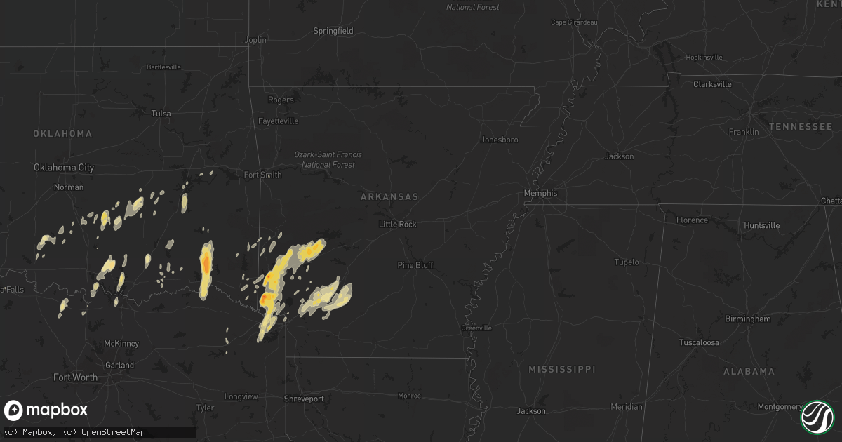
Hail Map in Arkansas on April 28, 2016
Get this storm
April 28 map
$229
one time, instant access
Download today. No call, no setup
Keep the $229
Bought the map and want the full workflow? Apply the entire $229 to a subscription within 7 days. None of it is wasted.
Every map, not just this one
This buys you this map. Subscription and you get every map we run, in the markets you choose from a few cities to whole states to nationwide. Plus real-time alerts the moment a storm fires.
Contact data
Name, contact info, occupancy, even credit band for addresses in the footprint. You go from where it hit to who to call.
Become the source they trust
Unlimited branding weather history reports on demand. You already have the documented answer ready for the property owner, and you are the one who showed up with it.
Property data and RoofTrace estimates
Pull up any address you have got, its value and the exact code rules for that jurisdiction, straight from One Click Code. Then RoofTrace estimates the squares, pitch, and roof value, priced the way you price.
Storm reports in Arkansas
Arkansas
| Date | Description |
|---|---|
| 04/28/20166:14 AM CDT | A local report indicates 1.00 inch wind near PRESCOTT |
| 04/28/20164:21 AM CDT | A local report indicates 1.75 inch wind near DE QUEEN |
| 04/28/20164:20 AM CDT | A local report indicates 2.00 inch wind near DE QUEEN |
| 04/28/20164:02 AM CDT | A local report indicates 1.00 inch wind near LOCKESBURG |
| 04/28/20163:34 AM CDT | Photo of large hail sent to ksla-tv from public. |
| 04/28/20163:34 AM CDT | Sheriff reports golfball size hail in the cross roads community. |
All States Impacted by Hail Map on April 28, 2016
Cities Impacted by Hail Map on April 28, 2016
- Amarillo, TX
- Mount Olive, NC
- Newton Grove, NC
- Four Oaks, NC
- Raton, NM
- Porum, OK
- Plains, KS
- Belhaven, NC
- Scranton, NC
- Clayton, NM
- Fritch, TX
- Borger, TX
- Turkey, TX
- Quitaque, TX
- Lockney, TX
- Childress, TX
- Silverton, TX
- Dumas, TX
- Sunray, TX
- Channing, TX
- Stinnett, TX
- Spearman, TX
- Rattan, OK
- Fort Towson, OK
- Long Bottom, OH
- Reedsville, OH
- Belleville, WV
- Ravenswood, WV
- Washington, AR
- Fulton, AR
- Hope, AR
- Chatham, VA
- Blairs, VA
- Mebane, NC
- Burlington, NC
- Liberty, NC
- Pittsboro, NC
- Snow Camp, NC
- Whitsett, NC
- Chapel Hill, NC
- Graham, NC
- Julian, NC
- Germanton, NC
- Pinnacle, NC
- King, NC
- Rushville, IN
- Palestine, WV
- Elizabeth, WV
- Alton, VA
- Mcalester, OK
- Faison, NC
- Clinton, NC
- Comanche, OK
- Roy, NM
- Idabel, OK
- Haworth, OK
- Gibsonville, NC
- Greensboro, NC
- Browns Summit, NC
- McLeansville, NC
- Denison, TX
- Sherman, TX
- Pottsboro, TX
- Belton, TX
- Rockbridge, OH
- Logan, OH
- Spring Hope, NC
- Louisburg, NC
- Elida, NM
- Flemington, WV
- Grafton, WV
- Bridgeport, WV
- Jackson, AL
- Hollis, OK
- Gould, OK
- Hereford, TX
- Ocean Springs, MS
- Perryton, TX
- Hope Mills, NC
- Fayetteville, NC
- Lawsonville, NC
- Danbury, NC
- Westfield, NC
- Sandy Ridge, NC
- Lockesburg, AR
- Miami, TX
- South Bloomingville, OH
- Texhoma, OK
- Stratford, TX
- Dodson, TX
- Mangum, OK
- Memphis, TX
- Duke, OK
- Marlow, OK
- Stratford, OK
- Ada, OK
- Roff, OK
- Farwell, TX
- South Salem, OH
- Bainbridge, OH
- Greenfield, OH
- Calypso, NC
- Dunn, NC
- Walnut Cove, NC
- Madison, NC
- Claudville, VA
- Mount Airy, NC
- Rogers, NM
- Portales, NM
- Pep, NM
- Clovis, NM
- Texico, NM
- Moatsville, WV
- Gainesville, TX
- Summerfield, NC
- Stewart, OH
- Athens, OH
- Amesville, OH
- Millfield, OH
- Beverly, WV
- Mabie, WV
- Morse, TX
- Dalhart, TX
- Waynesboro, GA
- Girard, GA
- Summerville, SC
- North Charleston, SC
- Charleston, SC
- Ravenel, SC
- Johns Island, SC
- Tarboro, NC
- Grove Hill, AL
- Leroy, AL
- Whatley, AL
- Gainestown, AL
- Franklin, AL
- Gate, OK
- Rosston, OK
- Rosston, AR
- Buckner, AR
- Brooklyn, MS
- Beaver, OK
- Laverne, OK
- Forgan, OK
- Cary, NC
- Raleigh, NC
- Leesburg, OH
- Wilmington, OH
- Jamestown, OH
- Xenia, OH
- Caney, OK
- Atoka, OK
- Pilot Mountain, NC
- Battleboro, NC
- Whitakers, NC
- Felt, OK
- Marietta, OH
- Prescott, AR
- Walker, WV
- Winfield, WV
- Hurricane, WV
- Suffolk, VA
- Paducah, TX
- Cee Vee, TX
- Godwin, NC
- Wade, NC
- Autryville, NC
- Sulphur, OK
- Mount Ida, AR
- Bonnerdale, AR
- Norman, AR
- Glenwood, AR
- Caddo Gap, AR
- Langley, AR
- Apex, NC
- Holly Springs, NC
- South Boston, VA
- Olin, NC
- Mena, AR
- De Queen, AR
- Dierks, AR
- Horatio, AR
- Umpire, AR
- Newhope, AR
- Guymon, OK
- Tallmansville, WV
- Buckhannon, WV
- Coalton, WV
- Vernon Hill, VA
- Sutherlin, VA
- Ringgold, VA
- Keeling, VA
- Halifax, VA
- Dillwyn, VA
- Buckingham, VA
- Cumberland, VA
- Farmville, VA
- Linden, NC
- Lillington, NC
- Bunnlevel, NC
- Spring Lake, NC
- Erwin, NC
- Homer, IN
- Glenwood, IN
- Manilla, IN
- Arlington, IN
- Matador, TX
- Statesville, NC
- Mocksville, NC
- Harmony, NC
- Penhook, VA
- Danville, VA
- Glade Hill, VA
- Roxboro, NC
- Callands, VA
- Rocky Mount, VA
- Virgilina, VA
- Dry Fork, VA
- Marietta, OK
- Whitesboro, TX
- Georgetown, SC
- Jamestown, SC
- Amistad, NM
- Mosquero, NM
- Duncan, OK
- Saint Jo, TX
- Gatesville, TX
- Davisville, WV
- Parkersburg, WV
- Mineral Wells, WV
- Glouster, OH
- Buchtel, OH
- Union Furnace, OH
- Cutler, OH
- Laurelville, OH
- Nelsonville, OH
- Haydenville, OH
- Fort Hood, TX
- Temple, TX
- Friona, TX
- Panhandle, TX
- Masterson, TX
- Hartley, TX
- Canadian, TX
- Vega, TX
- Skellytown, TX
- Pampa, TX
- Floydada, TX
- Murfreesboro, AR
- Middlesex, NC
- Bailey, NC
- Okolona, AR
- Gurdon, AR
- Blevins, AR
- Emmet, AR
- Kenly, NC
- Soper, OK
- Antlers, OK
- Turpin, OK
- Balko, OK
- Smithville, OK
- Hatfield, AR
- Stringtown, OK
- Daisy, OK
- Petroleum, WV
- Nashoba, OK
- Broken Bow, OK
- Eagletown, OK
- Allen, OK
- Calvin, OK
- Wildorado, TX
- New Hill, NC
- Wake Forest, NC
- Youngsville, NC
- Pleasant Garden, NC
- Climax, NC
- Garner, NC
- Fuquay Varina, NC
- Morrisville, NC
- Bunn, NC
- Rolesville, NC
- Wendell, NC
- Willow Spring, NC
- Moncure, NC
- Zebulon, NC
- Lane, OK
- Lorenzo, TX
- Moody, TX
- Forestburg, TX
- Plainview, TX
- Hale Center, TX
- Clayton, NC
- Benson, NC
- Washington, WV
- Macfarlan, WV
- Little Hocking, OH
- Munday, WV
- Boise City, OK
- Lamar, OK
- Sanford, NC
- Enfield, NC
- Montrose, WV
- Williamston, NC
- Glady, WV
- Canyon, TX
- Bluff City, AR
- Chidester, AR
- Smithfield, NC
- Semora, NC
- Lexington, NC
- Fairfield, NC
- Coolville, OH
- Brohard, WV
- Smithville, WV
- Vincent, OH
- Belpre, OH
- Booker, TX
- Ralls, TX
- Tuskahoma, OK
- Clayton, OK
- Happy, TX
- Claude, TX
- Holdenville, OK
- Texline, TX
- Mill Creek, OK
- Madill, OK
- Tishomingo, OK
- Mannsville, OK
- Atwood, OK
- Creswell, NC
- Watson, OK
- Le Roy, WV
- Pittsburg, TX
- Pauls Valley, OK
- Fowler, KS
- Meade, KS
- Reidsville, NC
- Milburn, OK
- Coleman, OK
- New Boston, TX
- Ashdown, AR
- Hooks, TX
- Stuart, OK
- Andrews, SC
- Elon, NC
- Winthrop, AR
- Foreman, AR
- Grady, AL
- Vidalia, GA
- Maud, TX
- Milton, NC
- Paoli, OK
- Jetersville, VA
- Amelia Court House, VA
- Salado, TX
- Chesapeake, VA
- Portsmouth, VA
- Highland Home, AL
- Lapine, AL
- Goodwell, OK
- Gruver, TX
- Texhoma, TX
- Goose Creek, SC
- Ladson, SC
- Selma, NC
- Hennepin, OK
- Elmore City, OK
- Tussy, OK
- Bennington, OK
- Cove, AR
- Blossom, TX
- Snow, OK
- Sawyer, OK
- Detroit, TX
- Arthur City, TX
- Paris, TX
- Hugo, OK
- Knightdale, NC
- Boswell, OK
- Nashville, NC
- Bartlett, TX
- Vandervoort, AR
- Pine Hall, NC
- Nolanville, TX
- Killeen, TX
- Harker Heights, TX
- Picayune, MS
- Perkinston, MS
- Eufaula, OK
- Kernersville, NC
- Walkertown, NC
- Stokesdale, NC
- Belews Creek, NC
- Hanna, OK
- Dustin, OK
- Littlefield, TX
- Amherst, TX
- Bovina, TX
- Tulia, TX
- Thornton, WV
- Tunnelton, WV
- Angier, NC
- Ardmore, OK
- Konawa, OK
- Swanquarter, NC
- Big Springs, WV
- Shinnston, WV
- Salemburg, NC
- Roseboro, NC
- Sedan, NM
- Texarkana, TX
- Kirby, AR
- Naples, TX
- Douglassville, TX
- Alleene, AR
- Marietta, TX
- Royal, AR
- Gillham, AR
- Nashville, AR
- Wilton, AR
- Simms, TX
- Amity, AR
- Grantsville, WV
- Arnoldsburg, WV
- Mount Zion, WV
- Creston, WV
- Fort Bragg, NC
- Orlando, FL
- Coats, NC
- Sanderson, FL
- Kress, TX
- New Plymouth, OH
- Guysville, OH
- Kissimmee, FL
- Mead, OK
- Kingston, OK
- Mineral Springs, AR
- Creola, OH
- Jarrell, TX
- Kenefic, OK
- Durant, OK
- Lavaca, AR
- Kismet, KS
- Arkadelphia, AR
- Creedmoor, NC
- Mount Pleasant, TX
- Lelia Lake, TX
- Hedley, TX
- Spring Valley, OH
- Dayton, OH
- Bellbrook, OH
- Oxford, NC
- Texarkana, AR
- Carriere, MS
- Durham, NC
- Saint Cloud, FL
- Ararat, NC
- Circleville, OH
- Chesterhill, OH
- Amanda, OH
- Big Bend, WV
- Spencer, WV
- Green Pond, SC
- Roper, NC
- New Augusta, MS
- Henderson, NV
- Saint Martinville, LA
- Ozan, AR
- McCaskill, AR
- Elm City, NC
- Wilson, NC
- Broadway, NC
- Cameron, NC
- Troy, AL
- Byars, OK
- Holly, CO
- Sudan, TX
- Foster, OK
- Lindsay, OK
- Long Beach, MS
- Alma, GA
- Hazlehurst, GA
- Taylorsville, NC
- Moravian Falls, NC
- Pep, TX
- Stonewall, OK
- Levelland, TX
- King William, VA
- Manquin, VA
- Rockport, WV
- Rocky Mount, NC
- Grant, OK
- Sabina, OH
- Port William, OH
- Lyons, GA
- Haw River, NC
- Sandyville, WV
- Virginia Beach, VA
- Lumberport, WV
- Middlebourne, WV
- Opelousas, LA
- Como, NC
- Gates, NC
- Stuart, VA
- Muenster, TX
- Goldsboro, NC
- Java, VA
- Gretna, VA
- Sasakwa, OK
- Greenville, NC
- Fountain, NC
- Macclesfield, NC
- Petersburg, TX
- Henderson, NC
- Norfolk, VA
- Granada, CO
- Gulfport, MS
- Ogden, AR
- Caddo, OK
- Talco, TX
- Summerfield, TX
- Muleshoe, TX
- Castalia, NC
- Theriot, LA
- Reedy, WV
- Raeford, NC
- Wichita Falls, TX
- Waverly, WV
- Elkins, WV
- Friendly, WV
- Harrisville, WV
- Union Hall, VA
- Ararat, VA


