Hail Map on April 28, 2016
Get this storm
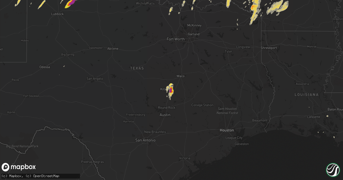
April 28 map
$229
one time, instant access
Download today. No call, no setup
Keep the $229
Bought the map and want the full workflow? Apply the entire $229 to a subscription within 7 days. None of it is wasted.
Every map, not just this one
This buys you this map. Subscription and you get every map we run, in the markets you choose from a few cities to whole states to nationwide. Plus real-time alerts the moment a storm fires.
Contact data
Name, contact info, occupancy, even credit band for addresses in the footprint. You go from where it hit to who to call.
Become the source they trust
Unlimited branding weather history reports on demand. You already have the documented answer ready for the property owner, and you are the one who showed up with it.
Property data and RoofTrace estimates
Pull up any address you have got, its value and the exact code rules for that jurisdiction, straight from One Click Code. Then RoofTrace estimates the squares, pitch, and roof value, priced the way you price.
States Impacted by Hail Map on April 28, 2016
Storm reports
Indiana
| Date | Description |
|---|---|
| 04/28/20164:00 PM CDT | Tree down near the intersection of hoover rd. And lacy rd. |
| 04/28/20163:53 PM CDT | A local report indicates 1.50 inch wind near S LOGAN |
| 04/28/20163:31 PM CDT | Tree down near the intersection of hoover rd. And lacy rd. Time estimated from radar. |
| 04/28/20162:52 PM CDT | A local report indicates 1.00 inch wind near RUSHVILLE |
| 04/28/20162:50 PM CDT | A local report indicates 1.75 inch wind near RUSHVILLE |
| 04/28/20162:48 PM CDT | A local report indicates 1.00 inch wind near RUSHVILLE |
Ohio
| Date | Description |
|---|---|
| 04/28/20166:48 PM CDT | Trained spotter reported 1 inch diameter hail in lawn north of jackson. |
| 04/28/20166:07 PM CDT | Dime to quarter sized hail. Time estimated from radar. |
| 04/28/20165:37 PM CDT | A local report indicates 1.00 inch wind near XENIA |
| 04/28/20165:36 PM CDT | Nickel to quarter size hail reported. |
| 04/28/20165:33 PM CDT | A local report indicates 1.00 inch wind near 4 WSW XENIA |
| 04/28/20164:50 PM CDT | A local report indicates 1.00 inch wind near 2 SSE BARTLETT |
| 04/28/20164:45 PM CDT | Cars dented |
| 04/28/20164:25 PM CDT | Hail lasted about 10 minutes |
| 04/28/20164:20 PM CDT | Coating the ground |
| 04/28/20164:18 PM CDT | Reported by 911 center in athens - dime to quarter sized in nelsonville |
| 04/28/20164:00 PM CDT | A local report indicates 1.00 inch wind near 2 SE LOGAN |
| 04/28/20163:59 PM CDT | A local report indicates 1.75 inch wind near HAYDENVILLE |
| 04/28/20163:55 PM CDT | A local report indicates 2.00 inch wind near 2 S LOGAN |
| 04/28/20163:53 PM CDT | A local report indicates 1.50 inch wind near 4 S LOGAN |
| 04/28/20163:41 PM CDT | A local report indicates 1.00 inch wind near 3 NNE GIBISONVILLE |
South Carolina
| Date | Description |
|---|---|
| 04/28/20164:08 PM CDT | Tree down on highway 61. |
| 04/28/20163:58 PM CDT | A local report indicates 1.00 inch wind near 1 NNW ARCHDALE |
Virginia
| Date | Description |
|---|---|
| 04/28/20166:45 PM CDT | Tree down on river road. |
| 04/28/20166:43 PM CDT | Tree down on brooklyn road. |
| 04/28/20164:45 PM CDT | Varying sizes largest estimated to be golf ball size |
| 04/28/20164:35 PM CDT | Quarter size hail reported at the cluster springs fire department...relayed from 911 center. |
| 04/28/20164:25 PM CDT | A local report indicates 2.50 inch wind near TURBEVILLE |
| 04/28/20164:15 PM CDT | Quarter size hail in elmo |
| 04/28/20163:40 PM CDT | A local report indicates 1.00 inch wind near 4 N KEELING |
| 04/28/20163:30 PM CDT | Eported hail for a duration of 15 minutes. Largest being 1 inch. |
| 04/28/20163:25 PM CDT | A local report indicates 1.50 inch wind near CHATHAM |
| 04/28/20163:18 PM CDT | Nickle to quarter sized hail. |
| 04/28/20163:18 PM CDT | 1 hail covering the ground. |
| 04/27/20169:22 PM CDT | Reported at craney island in portsmouth |
| 04/27/20169:18 PM CDT | Windshield broken...time estimated by radar |
| 04/27/20167:40 PM CDT | A local report indicates 1.00 inch wind near HILLCREST |
| 04/27/20167:31 PM CDT | Public reports hail of at least quarter size |
North Carolina
| Date | Description |
|---|---|
| 04/28/20166:45 PM CDT | A local report indicates 1.00 inch wind near JORDAN LAKE |
| 04/28/20166:27 PM CDT | A local report indicates 1.50 inch wind near FAISON |
| 04/28/20166:02 PM CDT | Tree down blocking hobbton hwy. |
| 04/28/20166:00 PM CDT | Golf ball size hail at the high school. Car windshields were damaged. |
| 04/28/20165:35 PM CDT | Trees down and resulting power outages. |
| 04/28/20165:32 PM CDT | Multiple downed trees along hwy 501. |
| 04/28/20165:30 PM CDT | Spotter reported multiple large trees down blocking hwy 96 approximately 3 miles se of rolesville. Also reported quarter size hail. |
| 04/28/20165:30 PM CDT | Media relay report of 1.5 to 2.5 inch hail. |
| 04/28/20165:30 PM CDT | 2 inch hail reported east of ponzer |
| 04/28/20165:30 PM CDT | Spotter reported multiple large trees down blocking hwy 96 approximately 3 miles se of rolesville. Also reported quarter size hail. |
| 04/28/20165:30 PM CDT | Tree down 10400 block of boston rd |
| 04/28/20165:07 PM CDT | Tree uprooted and blown on to a house. |
| 04/28/20165:05 PM CDT | A local report indicates 1.00 inch wind near 2 ENE SUMMERFIELD |
| 04/28/20165:05 PM CDT | Numerous large trees down and 1/2 dollar size hail. |
| 04/28/20164:47 PM CDT | Nws employee in angier reported quarter size hail. |
| 04/28/20164:45 PM CDT | Tree down on warrier lane near high rock road. |
| 04/28/20164:38 PM CDT | A few trees down near hillsborough street and blue ridge road. |
| 04/28/20164:20 PM CDT | Observed near intersection of us 64 and i-40 |
| 04/28/20164:19 PM CDT | A 3 mile stretch of hwy 54 closed due to hail covering the road... Which resulted in numerous car collisions and slide-offs. Hail depth (rah |
| 04/28/20164:15 PM CDT | A local report indicates 1.25 inch wind near REIDSVILLE |
| 04/28/20164:15 PM CDT | Quarter size hail near belews lake. |
| 04/28/20164:00 PM CDT | Hail the size of golf balls which whitened the ground and did some plant damage. Nws raleigh thanks the piedmont feed & garden center for the report. |
| 04/28/20163:44 PM CDT | A local report indicates 1.25 inch wind near 3 SW HARMONY |
| 04/28/20163:44 PM CDT | A local report indicates 1.00 inch wind near 4 W HARMONY |
| 04/28/20163:37 PM CDT | Hail the size of golf balls as well as small limbs broken. |
| 04/28/20163:30 PM CDT | Couple of trees down on power lines knocking power poles down on cassandra road. |
| 04/28/20163:15 PM CDT | A local report indicates 1.50 inch wind near 3 SW HARMONY |
| 04/28/20162:36 PM CDT | Hail lasted from 326 pm until 336 pm. |
| 04/27/20168:30 PM CDT | Tree down at 440 and western |
| 04/27/20168:28 PM CDT | Tree down at deboy st and schaub dr. |
West Virginia
| Date | Description |
|---|---|
| 04/28/20166:23 PM CDT | Mostly penny and nickel sized hail with a few as large as a quarter. |
| 04/28/20165:45 PM CDT | Torrential rainfall |
| 04/28/20165:26 PM CDT | A local report indicates 1.75 inch wind near MINERALWELLS |
| 04/28/20165:20 PM CDT | Trained spotter measured several hail pieces of 1.5 inches |
| 04/28/20165:15 PM CDT | A local report indicates 1.75 inch wind near 3 SE THORNTON |
| 04/28/20165:15 PM CDT | Half dollar size hail in lubeck |
| 04/28/20165:15 PM CDT | A local report indicates 1.00 inch wind near 3 SW ISRAEL |
| 04/28/20165:10 PM CDT | Most of the hail was dize size but some up to ping pong ball size |
| 04/28/20165:10 PM CDT | A local report indicates 1.25 inch wind near 3 SW FELLOWSVILLE |
| 04/28/20165:10 PM CDT | Golf ball sized hail reported at golf course |
| 04/28/20165:01 PM CDT | Harrison/taylor 911 called in reporting golfballs up to tennis balls in grafton per sheriff |
| 04/28/20164:58 PM CDT | Harrison/taylor 911 called in reporting golfballs up to tennis balls in grafton per sheriff. Damage to sheriff vehicles. |
| 04/28/20164:53 PM CDT | Viewer photo... Estimated size based on hailstones in hand |
| 04/28/20164:52 PM CDT | Telephones and trees down |
| 04/28/20164:52 PM CDT | Numerous reports of vehicle damage... School windows broken |
| 04/28/20164:50 PM CDT | A local report indicates 1.50 inch wind near KNOTTSVILLE |
| 04/28/20164:18 PM CDT | Via social media |
| 04/28/20164:18 PM CDT | A local report indicates 1.00 inch wind near 2 SE BEVERLY |
| 04/28/20164:16 PM CDT | Hail only lasted several minutes...no significant wind |
| 04/28/20164:10 PM CDT | A local report indicates 1.25 inch wind near 2 NW BEVERLY |
| 04/28/20163:27 PM CDT | A local report indicates 1.00 inch wind near 5 WSW ELIZABETH |
| 04/28/20162:01 PM CDT | Report of hail up to 1 inch in diameter around leroy. Time estimated from radar. |
Texas
| Date | Description |
|---|---|
| 04/28/20166:36 PM CDT | Ping pong ball size hail just south of sunray with hail accumulating on roadways. |
| 04/28/20166:25 PM CDT | A local report indicates 1.00 inch wind near 3 S ESTELLINE |
| 04/28/20166:25 PM CDT | Lots of tree limbs down... Wind gusts estimated to be around 60 mph. |
| 04/28/20166:20 PM CDT | Snapped power poles at fm1060 and county road i |
| 04/28/20166:19 PM CDT | Golf ball size hail reported just south of dumas with significantly reduced visibility and strong winds. |
| 04/28/20165:51 PM CDT | A local report indicates 2.00 inch wind near 3 E FLOYDADA |
| 04/28/20165:47 PM CDT | A local report indicates 1.50 inch wind near 2 E FLOYDADA |
| 04/28/20165:45 PM CDT | A local report indicates 1.75 inch wind near 7 SSW FLOYDADA |
| 04/28/20165:43 PM CDT | A local report indicates 1.75 inch wind near 5 S FLOYDADA |
| 04/28/20165:32 PM CDT | A local report indicates 2.00 inch wind near 6 SSW FLOYDADA |
| 04/28/20165:30 PM CDT | Lots of broken windows... Windshields... Lots of broken tree limbs |
| 04/28/20165:30 PM CDT | Lots of broken windows... Windshields... Lots of broken tree limbs |
| 04/28/20165:24 PM CDT | A local report indicates 1.00 inch wind near TURKEY |
| 04/28/20165:23 PM CDT | Lots of hail from pea size up to golf ball size hail reported on highway 385. |
| 04/28/20165:16 PM CDT | A local report indicates 1.75 inch wind near CAPROCK CANYON SP |
| 04/28/20165:15 PM CDT | Lasted for 20 minutes |
| 04/28/20165:14 PM CDT | A local report indicates 2.00 inch wind near 3 N CONE |
| 04/28/20165:10 PM CDT | Dents in equipment... Minor damage |
| 04/28/20165:08 PM CDT | A local report indicates 1.75 inch wind near QUITAQUE |
| 04/28/20164:40 PM CDT | Media storm chaser - report near south plains |
| 04/28/20164:25 PM CDT | A local report indicates 1.50 inch wind near N LOCKNEY |
| 04/28/20164:24 PM CDT | Dime to quarter-sized hail falling in lockney |
| 04/28/20162:28 AM CDT | Quarter size hail reported at red river army dept fire dept. |
| 04/28/20162:10 AM CDT | Quarter size hail in st. Jo |
| 04/28/20161:16 AM CDT | A local report indicates 1.00 inch wind near TEXHOMA |
| 04/28/201612:54 AM CDT | Power poles blown down |
| 04/28/201612:49 AM CDT | Also half inch hail. No damage observed |
| 04/27/20169:52 PM CDT | A local report indicates 61 MPH wind near 7 ESE LORA |
| 04/27/20169:39 PM CDT | Half dollar size hail on s kiowa street near hwy 60 in miami. |
| 04/27/20169:34 PM CDT | Hail up to golf ball on highway 60 in miami. |
| 04/27/20169:15 PM CDT | Golfball size hail reported west of belton high school. |
| 04/27/20169:10 PM CDT | Half dollar size hail reported 2 miles sw of belton. |
| 04/27/20169:01 PM CDT | Quarter size hail reported in morgan's point resort. |
| 04/27/20168:52 PM CDT | 2 inch size hail reported west of belton near stillhouse hollow lake. |
| 04/27/20168:49 PM CDT | Half dollar size hail reported in belton |
| 04/27/20168:42 PM CDT | Quarter size hail reported in south side of belton... Half a mile north of expo center |
| 04/27/20168:34 PM CDT | 4 inch branches brought down. |
| 04/27/20168:30 PM CDT | A local report indicates 1.75 inch wind near 2 E BORGER |
| 04/27/20168:29 PM CDT | Two inch hail busted windshield on highway 70 south of perryton. |
| 04/27/20168:28 PM CDT | A local report indicates 1.00 inch wind near 3 NE BORGER |
| 04/27/20168:20 PM CDT | A local report indicates 1.00 inch wind near 2 W BORGER |
| 04/27/20168:09 PM CDT | In buena vista |
| 04/27/20168:08 PM CDT | A local report indicates 1.75 inch wind near FRITCH |
| 04/27/20168:05 PM CDT | 4 inch diameter tree branch broken due to thunderstorm wind and fell on power line and is causing sparks |
| 04/27/20168:03 PM CDT | Dime to quarter size hail beginning to cover road in fritch with moderate rain. No flooding noticed at this time with it being more hail than rain. |
| 04/27/20168:01 PM CDT | Quarter size hail reported south of fritch. Report relayed by broadcast media. |
| 04/27/20167:59 PM CDT | A local report indicates 1.25 inch wind near FRITCH |
| 04/27/20167:58 PM CDT | At lake meredith harbor |
| 04/27/20167:55 PM CDT | A local report indicates 1.00 inch wind near 1 S FRITCH |
| 04/27/20167:51 PM CDT | At double diamond |
| 04/27/20167:37 PM CDT | A local report indicates 1.75 inch wind near STINNETT |
| 04/27/20167:33 PM CDT | A local report indicates 1.75 inch wind near 4 N STINNETT |
| 04/27/20167:30 PM CDT | A local report indicates 1.00 inch wind near CEE VEE |
| 04/27/20167:13 PM CDT | Half dollar size hail reported south of masterson. |
Arkansas
| Date | Description |
|---|---|
| 04/28/20166:14 AM CDT | A local report indicates 1.00 inch wind near PRESCOTT |
| 04/28/20164:21 AM CDT | A local report indicates 1.75 inch wind near DE QUEEN |
| 04/28/20164:20 AM CDT | A local report indicates 2.00 inch wind near DE QUEEN |
| 04/28/20164:02 AM CDT | A local report indicates 1.00 inch wind near LOCKESBURG |
| 04/28/20163:34 AM CDT | Photo of large hail sent to ksla-tv from public. |
| 04/28/20163:34 AM CDT | Sheriff reports golfball size hail in the cross roads community. |
Oklahoma
| Date | Description |
|---|---|
| 04/28/20163:25 AM CDT | Pea sized hail covered ground up to a foot...brief wind gust to 60 mph. |
| 04/28/20163:12 AM CDT | A local report indicates 1.50 inch wind near 6 NNE MADILL |
| 04/28/20162:30 AM CDT | Also 60 to 65 mph wind gust reported. |
| 04/27/20167:26 PM CDT | A local report indicates 1.75 inch wind near HOLLIS |
Kansas
| Date | Description |
|---|---|
| 04/28/20162:35 AM CDT | Trained spotter measured a 77 mph wind gust on a home weather station. Time is estimated from radar. |
Cities Impacted by Hail Map on April 28, 2016
- Amarillo, TX
- Mount Olive, NC
- Newton Grove, NC
- Four Oaks, NC
- Raton, NM
- Porum, OK
- Plains, KS
- Belhaven, NC
- Scranton, NC
- Clayton, NM
- Fritch, TX
- Borger, TX
- Turkey, TX
- Quitaque, TX
- Lockney, TX
- Childress, TX
- Silverton, TX
- Dumas, TX
- Sunray, TX
- Channing, TX
- Stinnett, TX
- Spearman, TX
- Rattan, OK
- Fort Towson, OK
- Long Bottom, OH
- Reedsville, OH
- Belleville, WV
- Ravenswood, WV
- Washington, AR
- Fulton, AR
- Hope, AR
- Chatham, VA
- Blairs, VA
- Mebane, NC
- Burlington, NC
- Liberty, NC
- Pittsboro, NC
- Snow Camp, NC
- Whitsett, NC
- Chapel Hill, NC
- Graham, NC
- Julian, NC
- Germanton, NC
- Pinnacle, NC
- King, NC
- Rushville, IN
- Palestine, WV
- Elizabeth, WV
- Alton, VA
- Mcalester, OK
- Faison, NC
- Clinton, NC
- Comanche, OK
- Roy, NM
- Idabel, OK
- Haworth, OK
- Gibsonville, NC
- Greensboro, NC
- Browns Summit, NC
- McLeansville, NC
- Denison, TX
- Sherman, TX
- Pottsboro, TX
- Belton, TX
- Rockbridge, OH
- Logan, OH
- Spring Hope, NC
- Louisburg, NC
- Elida, NM
- Flemington, WV
- Grafton, WV
- Bridgeport, WV
- Jackson, AL
- Hollis, OK
- Gould, OK
- Hereford, TX
- Ocean Springs, MS
- Perryton, TX
- Hope Mills, NC
- Fayetteville, NC
- Lawsonville, NC
- Danbury, NC
- Westfield, NC
- Sandy Ridge, NC
- Lockesburg, AR
- Miami, TX
- South Bloomingville, OH
- Texhoma, OK
- Stratford, TX
- Dodson, TX
- Mangum, OK
- Memphis, TX
- Duke, OK
- Marlow, OK
- Stratford, OK
- Ada, OK
- Roff, OK
- Farwell, TX
- South Salem, OH
- Bainbridge, OH
- Greenfield, OH
- Calypso, NC
- Dunn, NC
- Walnut Cove, NC
- Madison, NC
- Claudville, VA
- Mount Airy, NC
- Rogers, NM
- Portales, NM
- Pep, NM
- Clovis, NM
- Texico, NM
- Moatsville, WV
- Gainesville, TX
- Summerfield, NC
- Stewart, OH
- Athens, OH
- Amesville, OH
- Millfield, OH
- Beverly, WV
- Mabie, WV
- Morse, TX
- Dalhart, TX
- Waynesboro, GA
- Girard, GA
- Summerville, SC
- North Charleston, SC
- Charleston, SC
- Ravenel, SC
- Johns Island, SC
- Tarboro, NC
- Grove Hill, AL
- Leroy, AL
- Whatley, AL
- Gainestown, AL
- Franklin, AL
- Gate, OK
- Rosston, OK
- Rosston, AR
- Buckner, AR
- Brooklyn, MS
- Beaver, OK
- Laverne, OK
- Forgan, OK
- Cary, NC
- Raleigh, NC
- Leesburg, OH
- Wilmington, OH
- Jamestown, OH
- Xenia, OH
- Caney, OK
- Atoka, OK
- Pilot Mountain, NC
- Battleboro, NC
- Whitakers, NC
- Felt, OK
- Marietta, OH
- Prescott, AR
- Walker, WV
- Winfield, WV
- Hurricane, WV
- Suffolk, VA
- Paducah, TX
- Cee Vee, TX
- Godwin, NC
- Wade, NC
- Autryville, NC
- Sulphur, OK
- Mount Ida, AR
- Bonnerdale, AR
- Norman, AR
- Glenwood, AR
- Caddo Gap, AR
- Langley, AR
- Apex, NC
- Holly Springs, NC
- South Boston, VA
- Olin, NC
- Mena, AR
- De Queen, AR
- Dierks, AR
- Horatio, AR
- Umpire, AR
- Newhope, AR
- Guymon, OK
- Tallmansville, WV
- Buckhannon, WV
- Coalton, WV
- Vernon Hill, VA
- Sutherlin, VA
- Ringgold, VA
- Keeling, VA
- Halifax, VA
- Dillwyn, VA
- Buckingham, VA
- Cumberland, VA
- Farmville, VA
- Linden, NC
- Lillington, NC
- Bunnlevel, NC
- Spring Lake, NC
- Erwin, NC
- Homer, IN
- Glenwood, IN
- Manilla, IN
- Arlington, IN
- Matador, TX
- Statesville, NC
- Mocksville, NC
- Harmony, NC
- Penhook, VA
- Danville, VA
- Glade Hill, VA
- Roxboro, NC
- Callands, VA
- Rocky Mount, VA
- Virgilina, VA
- Dry Fork, VA
- Marietta, OK
- Whitesboro, TX
- Georgetown, SC
- Jamestown, SC
- Amistad, NM
- Mosquero, NM
- Duncan, OK
- Saint Jo, TX
- Gatesville, TX
- Davisville, WV
- Parkersburg, WV
- Mineral Wells, WV
- Glouster, OH
- Buchtel, OH
- Union Furnace, OH
- Cutler, OH
- Laurelville, OH
- Nelsonville, OH
- Haydenville, OH
- Fort Hood, TX
- Temple, TX
- Friona, TX
- Panhandle, TX
- Masterson, TX
- Hartley, TX
- Canadian, TX
- Vega, TX
- Skellytown, TX
- Pampa, TX
- Floydada, TX
- Murfreesboro, AR
- Middlesex, NC
- Bailey, NC
- Okolona, AR
- Gurdon, AR
- Blevins, AR
- Emmet, AR
- Kenly, NC
- Soper, OK
- Antlers, OK
- Turpin, OK
- Balko, OK
- Smithville, OK
- Hatfield, AR
- Stringtown, OK
- Daisy, OK
- Petroleum, WV
- Nashoba, OK
- Broken Bow, OK
- Eagletown, OK
- Allen, OK
- Calvin, OK
- Wildorado, TX
- New Hill, NC
- Wake Forest, NC
- Youngsville, NC
- Pleasant Garden, NC
- Climax, NC
- Garner, NC
- Fuquay Varina, NC
- Morrisville, NC
- Bunn, NC
- Rolesville, NC
- Wendell, NC
- Willow Spring, NC
- Moncure, NC
- Zebulon, NC
- Lane, OK
- Lorenzo, TX
- Moody, TX
- Forestburg, TX
- Plainview, TX
- Hale Center, TX
- Clayton, NC
- Benson, NC
- Washington, WV
- Macfarlan, WV
- Little Hocking, OH
- Munday, WV
- Boise City, OK
- Lamar, OK
- Sanford, NC
- Enfield, NC
- Montrose, WV
- Williamston, NC
- Glady, WV
- Canyon, TX
- Bluff City, AR
- Chidester, AR
- Smithfield, NC
- Semora, NC
- Lexington, NC
- Fairfield, NC
- Coolville, OH
- Brohard, WV
- Smithville, WV
- Vincent, OH
- Belpre, OH
- Booker, TX
- Ralls, TX
- Tuskahoma, OK
- Clayton, OK
- Happy, TX
- Claude, TX
- Holdenville, OK
- Texline, TX
- Mill Creek, OK
- Madill, OK
- Tishomingo, OK
- Mannsville, OK
- Atwood, OK
- Creswell, NC
- Watson, OK
- Le Roy, WV
- Pittsburg, TX
- Pauls Valley, OK
- Fowler, KS
- Meade, KS
- Reidsville, NC
- Milburn, OK
- Coleman, OK
- New Boston, TX
- Ashdown, AR
- Hooks, TX
- Stuart, OK
- Andrews, SC
- Elon, NC
- Winthrop, AR
- Foreman, AR
- Grady, AL
- Vidalia, GA
- Maud, TX
- Milton, NC
- Paoli, OK
- Jetersville, VA
- Amelia Court House, VA
- Salado, TX
- Chesapeake, VA
- Portsmouth, VA
- Highland Home, AL
- Lapine, AL
- Goodwell, OK
- Gruver, TX
- Texhoma, TX
- Goose Creek, SC
- Ladson, SC
- Selma, NC
- Hennepin, OK
- Elmore City, OK
- Tussy, OK
- Bennington, OK
- Cove, AR
- Blossom, TX
- Snow, OK
- Sawyer, OK
- Detroit, TX
- Arthur City, TX
- Paris, TX
- Hugo, OK
- Knightdale, NC
- Boswell, OK
- Nashville, NC
- Bartlett, TX
- Vandervoort, AR
- Pine Hall, NC
- Nolanville, TX
- Killeen, TX
- Harker Heights, TX
- Picayune, MS
- Perkinston, MS
- Eufaula, OK
- Kernersville, NC
- Walkertown, NC
- Stokesdale, NC
- Belews Creek, NC
- Hanna, OK
- Dustin, OK
- Littlefield, TX
- Amherst, TX
- Bovina, TX
- Tulia, TX
- Thornton, WV
- Tunnelton, WV
- Angier, NC
- Ardmore, OK
- Konawa, OK
- Swanquarter, NC
- Big Springs, WV
- Shinnston, WV
- Salemburg, NC
- Roseboro, NC
- Sedan, NM
- Texarkana, TX
- Kirby, AR
- Naples, TX
- Douglassville, TX
- Alleene, AR
- Marietta, TX
- Royal, AR
- Gillham, AR
- Nashville, AR
- Wilton, AR
- Simms, TX
- Amity, AR
- Grantsville, WV
- Arnoldsburg, WV
- Mount Zion, WV
- Creston, WV
- Fort Bragg, NC
- Orlando, FL
- Coats, NC
- Sanderson, FL
- Kress, TX
- New Plymouth, OH
- Guysville, OH
- Kissimmee, FL
- Mead, OK
- Kingston, OK
- Mineral Springs, AR
- Creola, OH
- Jarrell, TX
- Kenefic, OK
- Durant, OK
- Lavaca, AR
- Kismet, KS
- Arkadelphia, AR
- Creedmoor, NC
- Mount Pleasant, TX
- Lelia Lake, TX
- Hedley, TX
- Spring Valley, OH
- Dayton, OH
- Bellbrook, OH
- Oxford, NC
- Texarkana, AR
- Carriere, MS
- Durham, NC
- Saint Cloud, FL
- Ararat, NC
- Circleville, OH
- Chesterhill, OH
- Amanda, OH
- Big Bend, WV
- Spencer, WV
- Green Pond, SC
- Roper, NC
- New Augusta, MS
- Henderson, NV
- Saint Martinville, LA
- Ozan, AR
- McCaskill, AR
- Elm City, NC
- Wilson, NC
- Broadway, NC
- Cameron, NC
- Troy, AL
- Byars, OK
- Holly, CO
- Sudan, TX
- Foster, OK
- Lindsay, OK
- Long Beach, MS
- Alma, GA
- Hazlehurst, GA
- Taylorsville, NC
- Moravian Falls, NC
- Pep, TX
- Stonewall, OK
- Levelland, TX
- King William, VA
- Manquin, VA
- Rockport, WV
- Rocky Mount, NC
- Grant, OK
- Sabina, OH
- Port William, OH
- Lyons, GA
- Haw River, NC
- Sandyville, WV
- Virginia Beach, VA
- Lumberport, WV
- Middlebourne, WV
- Opelousas, LA
- Como, NC
- Gates, NC
- Stuart, VA
- Muenster, TX
- Goldsboro, NC
- Java, VA
- Gretna, VA
- Sasakwa, OK
- Greenville, NC
- Fountain, NC
- Macclesfield, NC
- Petersburg, TX
- Henderson, NC
- Norfolk, VA
- Granada, CO
- Gulfport, MS
- Ogden, AR
- Caddo, OK
- Talco, TX
- Summerfield, TX
- Muleshoe, TX
- Castalia, NC
- Theriot, LA
- Reedy, WV
- Raeford, NC
- Wichita Falls, TX
- Waverly, WV
- Elkins, WV
- Friendly, WV
- Harrisville, WV
- Union Hall, VA
- Ararat, VA