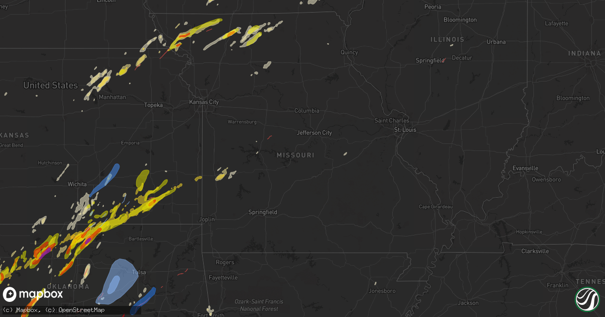
Hail Map in Missouri on April 27, 2024
Get this storm
April 27 map
$229
one time, instant access
Download today. No call, no setup
Keep the $229
Bought the map and want the full workflow? Apply the entire $229 to a subscription within 7 days. None of it is wasted.
Every map, not just this one
This buys you this map. Subscription and you get every map we run, in the markets you choose from a few cities to whole states to nationwide. Plus real-time alerts the moment a storm fires.
Contact data
Name, contact info, occupancy, even credit band for addresses in the footprint. You go from where it hit to who to call.
Become the source they trust
Unlimited branding weather history reports on demand. You already have the documented answer ready for the property owner, and you are the one who showed up with it.
Property data and RoofTrace estimates
Pull up any address you have got, its value and the exact code rules for that jurisdiction, straight from One Click Code. Then RoofTrace estimates the squares, pitch, and roof value, priced the way you price.
Storm reports in Missouri
Missouri
| Date | Description |
|---|---|
| 04/27/20246:40 PM CDT | Brief touchdown west of brookfield. Time estimated from radar. |
| 04/27/20246:34 PM CDT | 1 inch hail reported near osgood. Time estimate via radar. |
| 04/27/20246:02 PM CDT | Quarter-sized hail reported by emergency manager. |
| 04/27/20245:41 PM CDT | 1 inch hail reported by emergency manager. |
| 04/27/20245:09 PM CDT | Social media report of quarter size hail near bethany. Time and location estimated from social media report and radar. |
| 04/27/20245:02 PM CDT | Report from mping: ping pong ball |
| 04/27/20245:00 PM CDT | Social media report of half dollar size hail in bethany. Time estimated from radar. |
| 04/27/20244:58 PM CDT | A weak ef0 tornado began southeast of spickard east of 7th avenue... Producing sporadic and intermittent tree damage along its path. The tornado tracked north-northeast |
| 04/27/20244:19 PM CDT | Missouri highway police reported tornado crossing hwy 169. |
| 04/27/20244:13 PM CDT | Metal roof torn off residence. Metal in trees and some 4-6 inch limbs down. Time estimated via radar. |
| 04/27/20244:12 PM CDT | This ef1 tornado began near or just west of u.s. Highway 169 south of gentry... Where a tractor trailer was blown over. Little damage was observed as the tornado moved |
| 04/27/20244:10 PM CDT | Report from mping: golf ball |
| 04/27/20244:08 PM CDT | Powerlines down; outages reported. |
| 04/27/20243:54 PM CDT | Media partner reported quarter-sized hail just south of ravenwood... Mo along 136-hwy. |
| 04/27/20243:17 PM CDT | Social media report of half dollar size near maryville. Time estimated from radar. |
| 04/27/20243:00 PM CDT | Golf ball-sized hail along hwy 113 at 3pm. |
| 04/27/20242:30 PM CDT | Corrects previous hail report from corning. Mping report of half dollar size hail. |
| 04/27/20241:35 PM CDT | Mping report. |
| 04/27/20244:37 AM CDT | Photos via facebook - show trampoline damage... 5 small trees uprooted... Multiple trees/large tree branches snapped. |
| 04/27/20243:30 AM CDT | Numerous trees uprooted. |
| 04/27/20243:12 AM CDT | Photos from facebook. Tree split and another broke in half. |
| 04/27/20242:12 AM CDT | Facebook comment with photo - large tree limbs down... South of el dorado springs... 5 miles down hwy u. |
| 04/27/20241:05 AM CDT | Medium tree uprooted. Time estimated from radar. |
| 04/26/202411:02 PM CDT | Corrects previous tstm wnd dmg report from 1 n tipton. Three utility poles snapped just northeast of tipton along alexander rd. Time estimated from radar. |
| 04/26/202411:02 PM CDT | Photos show a mobile home was rolled off of its foundation and crushed. Time estimated from radar. |
| 04/26/202411:02 PM CDT | Damage to metal outbuilding. Time estimated from radar. |
| 04/26/202410:59 PM CDT | Scattered reports of power outages throughout cooper county. Time estimated from radar. |
| 04/26/202410:59 PM CDT | An ef1 tornado formed shortly before 11pm on the 27th northeast of tipton... Mo along alexander rd... Causing damage to both structures and trees before dissipating a m |
| 04/26/202410:59 PM CDT | Three utility poles snapped just north of tipton. Time estimated from radar. |
| 04/26/202410:30 PM CDT | Delayed report. Report from mping. 1-inch tree limbs broken... Shingles blown off. Time based on radar. |
| 04/26/202410:29 PM CDT | Trees were uprooted along ehlers and butterfield trail road to the southwest of florence during a tornado saturday evening. The tornado had max winds of 75 mph with a w |
| 04/26/202410:17 PM CDT | Delayed report. Report of an irrigation arm turned upside down and tree damage from the thunderstorms. Measured peak thunderstorm wind gust of 61 mph relayed from a coo |
| 04/26/202410:12 PM CDT | Delayed report. 5 trees uprooted... Multiple trees snapped in half or with missing limbs. |
| 04/26/202410:05 PM CDT | Downed power lines and power outages near quisenberry road. Time estimated from radar. |
| 04/26/20249:20 PM CDT | Downed power lines and power outages near 251st road. Time estimated from radar. |
| 04/26/20249:17 PM CDT | Downed power lines and power outages near 950 road. Time estimated from radar. |
| 04/26/20248:48 PM CDT | Power flashes reported 3 miles north of montrose with visible funnel. |
| 04/26/20248:46 PM CDT | Multiple 5-6 inch diameter tree limbs downed east of creighton. Timing estimated by radar. |
| 04/26/20248:45 PM CDT | A brief ef0 tornado occurred north of montrose from the same mesovortex that produced the tornado just southeast of butler. The first signs of damage occurred just west |
| 04/26/20248:44 PM CDT | Downed power lines and power outages near nw 100 rd. Time estimated from radar. |
| 04/26/20248:37 PM CDT | Several reports of power outages east of adrian. Time estimated from radar. |
| 04/26/20248:30 PM CDT | This ef1 tornado began just south of route 18 east of passaic. Some of the worst damage of the tornado affected a farm property... Where one outbuilding collapsed... An |
| 04/26/20248:26 PM CDT | Downed power lines and power outages near route e. Time estimated from radar. |
| 04/26/20248:23 PM CDT | This ef1 tornado began just east of route yy and just south of state highway 52 southeast of butler in bates county... Where minor tree damage was observed. The tornado |
| 04/26/20248:19 PM CDT | Downed power lines and power outages near route 52. Time estimated from radar. |
| 04/26/20248:15 PM CDT | Downed power lines and power outages near route pp. Time estimated from radar. |
| 04/26/20248:04 PM CDT | Sherriffs office reported power lines downed along hwy a near rich hill. Location estimated; timing estimated via radar. |
| 04/26/20248:00 PM CDT | Delayed social media report of multiple trees down on and near route u. Time estimated from radar. |
| 04/26/20247:14 PM CDT | Also observed minor ponding. Relayed via social media. |
| 04/26/20247:09 PM CDT | Downed power lines and power outages near 137th street. Time estimated from radar. |
| 04/26/20247:07 PM CDT | Downed power lines and power outages near silver lane. Time estimated from radar. |
| 04/26/20247:07 PM CDT | Downed power lines and power outages near 195th street. Time estimated from radar. |
| 04/26/20247:07 PM CDT | Downed power lines and power outages near summit road. Time based on dispatch report and confirmed from radar. |
| 04/26/20247:03 PM CDT | Downed power lines and power outages near westover road. Time estimated from radar. |
All States Impacted by Hail Map on April 27, 2024
Cities Impacted by Hail Map on April 27, 2024
- Bono, AR
- Shamrock, TX
- Wellington, TX
- Lakeview, TX
- Cheyenne, OK
- Sayre, OK
- Sweetwater, OK
- Wheeler, TX
- Mclean, TX
- Quail, TX
- Reydon, OK
- Hammon, OK
- Leedey, OK
- Okeene, OK
- Longdale, OK
- Briscoe, TX
- Isabella, OK
- Fairview, OK
- Ringwood, OK
- Ames, OK
- Taloga, OK
- Camargo, OK
- Meno, OK
- Paducah, TX
- Vici, OK
- Durham, OK
- Goltry, OK
- Carrier, OK
- Lahoma, OK
- Enid, OK
- Nash, OK
- Kremlin, OK
- Pond Creek, OK
- Seiling, OK
- Chester, OK
- Mutual, OK
- Mooreland, OK
- Medford, OK
- Helena, OK
- Jet, OK
- Waynoka, OK
- Braman, OK
- Cleo Springs, OK
- Aline, OK
- Quanah, TX
- Wellington, KS
- Wakefield, KS
- Abilene, KS
- Crowell, TX
- Canton, OK
- Jayton, TX
- South Haven, KS
- Geuda Springs, KS
- Oxford, KS
- Erick, OK
- Oakwood, OK
- Longford, KS
- Belle Plaine, KS
- Carmen, OK
- Aspermont, TX
- Junction City, KS
- Cherokee, OK
- Mulvane, KS
- Clay Center, KS
- Amorita, OK
- Grandfield, OK
- Winfield, KS
- Udall, KS
- Riley, KS
- Rose Hill, KS
- Douglass, KS
- Eldorado, OK
- Butler, OK
- Rock, KS
- Randolph, KS
- Leonardville, KS
- Green, KS
- Onaga, KS
- Dawson, NE
- Sabetha, KS
- Bern, KS
- Olsburg, KS
- Old Glory, TX
- Dacoma, OK
- Atlanta, KS
- Leon, KS
- Duke, OK
- Blue Rapids, KS
- Greenleaf, KS
- Elk City, OK
- Augusta, KS
- Altus, OK
- Blair, OK
- El Dorado, KS
- Rosalia, KS
- Eureka, KS
- Fairmont, OK
- Westmoreland, KS
- Hiawatha, KS
- Garber, OK
- Douglas, OK
- Barnes, KS
- Salem, NE
- Verdon, NE
- Seymour, TX
- Palmer, KS
- Hunter, OK
- Frankfort, KS
- White Cloud, KS
- Fairfax, MO
- Vermillion, KS
- Barnard, KS
- Mangum, OK
- Olustee, OK
- Lamont, OK
- Covington, OK
- Nardin, OK
- Axtell, KS
- Billings, OK
- Tonkawa, OK
- Lone Wolf, OK
- Skidmore, MO
- Caldwell, KS
- O'Brien, TX
- Craig, MO
- Centralia, KS
- Waterville, KS
- Falls City, NE
- Deer Creek, OK
- Knox City, TX
- Guthrie, OK
- Blackwell, OK
- Ponca City, OK
- Hobart, OK
- Corning, KS
- Goff, KS
- Brownell, KS
- La Crosse, KS
- Burlington Junction, MO
- Clearfield, IA
- Benton, IA
- Blockton, IA
- Diagonal, IA
- Mound City, MO
- Forest City, MO
- Bison, KS
- Wakita, OK
- Newkirk, OK
- Arkansas City, KS
- Vernon, TX
- Hays, KS
- Rock Port, MO
- Rulo, NE
- Maitland, MO
- Oneida, KS
- Seneca, KS
- Bazine, KS
- McCracken, KS
- Shannon City, IA
- Schoenchen, KS
- Liebenthal, KS
- Ransom, KS
- Ellis, KS
- Graham, MO
- Coyle, OK
- Perry, OK
- Two Buttes, CO
- Sentinel, OK
- Rocky, OK
- Cordell, OK
- Barnard, MO
- Maryville, MO
- Fairview, KS
- Stillwater, OK
- Walsh, CO
- Lenox, IA
- Knoxville, IA
- Victoria, KS
- Peck, KS
- Munday, TX
- Mountain View, OK
- Dexter, KS
- Conception Junction, MO
- Electra, TX
- Pleasantville, IA
- Otley, IA
- Imogene, IA
- Ridott, IL
- Freeport, IL
- Dakota, IL
- Morrison, OK
- Maple City, KS
- Morrill, KS
- Baileyville, KS
- Oregon, MO
- Carnegie, OK
- Ravenwood, MO
- Hydro, OK
- Cambridge, KS
- Pella, IA
- Randolph, IA
- Emerson, IA
- Malvern, IA
- Hastings, IA
- Sully, IA
- Marland, OK
- New Virginia, IA
- Gorham, KS
- Rock City, IL
- Afton, IA
- Natoma, KS
- Mayfield, KS
- Bolckow, MO
- Colony, OK
- Corn, OK
- Monroe, IA
- Reasnor, IA
- Indianola, IA
- Lookeba, OK
- Hinton, OK
- Harrold, TX
- Paradise, KS
- Weatherford, OK
- Milo, IA
- Ackworth, IA
- Oklaunion, TX
- Villisca, IA
- Elliott, IA
- Clyde, MO
- Goree, TX
- Davidson, OK
- Lynnville, IA
- Searsboro, IA
- Grinnell, IA
- Cedar Vale, KS
- Stanberry, MO
- Gentry, MO
- Sheridan, MO
- Conception, MO
- Worth, MO
- Parnell, MO
- Lewis, IA
- Waukomis, OK
- Cumberland, IA
- Bison, OK
- Atlantic, IA
- Waldo, KS
- Geary, OK
- Montezuma, IA
- Grant City, MO
- Denver, MO
- Hatfield, MO
- Martinsville, MO
- Calumet, OK
- Grenola, KS
- Hollister, OK
- Loveland, OK
- Frederick, OK
- Shidler, OK
- Wiota, IA
- King City, MO
- Union Star, MO
- Moline, KS
- Howard, KS
- Okarche, OK
- McFall, MO
- Epworth, IA
- Farley, IA
- Dyersville, IA
- Albany, MO
- Center Point, IA
- Walker, IA
- Newton, IA
- Malcom, IA
- Durango, IA
- Dubuque, IA
- Sherrill, IA
- Kingfisher, OK
- Kaw City, OK
- Mount Ayr, IA
- Gilman City, MO
- Trenton, MO
- Coggon, IA
- Ridgeway, MO
- Eagleville, MO
- Pattonsburg, MO
- Princeton, MO
- Bethany, MO
- Spickard, MO
- Elk Falls, KS
- Cuba City, WI
- Hazel Green, WI
- Potosi, WI
- Kieler, WI
- Platteville, WI
- Rochester, TX
- Rule, TX
- Ryan, IA
- New Hampton, MO
- Jameson, MO
- Cambridge, WI
- Deerfield, WI
- Hennessey, OK
- Watonga, OK
- Dover, OK
- Deep River, IA
- Brooklyn, IA
- Guernsey, IA
- Severy, KS
- Indiahoma, OK
- Newtown, MO
- Victor, IA
- Ladora, IA
- Delhi, IA
- Fall River, KS
- Longton, KS
- Manchester, IA
- Johnson Creek, WI
- Lake Mills, WI
- Watertown, WI
- Waterloo, WI
- Fredonia, KS
- Toronto, KS
- Virgil, KS
- Yates Center, KS
- Marshall, OK
- Neosho, WI
- Holy Cross, IA
- Belmont, WI
- Darlington, WI
- Shullsburg, WI
- Marengo, IA
- Lucien, OK
- Sedan, KS
- Coffey, MO
- Lucerne, MO
- Mulhall, OK
- Orlando, OK
- Buffalo, KS
- Lebanon, WI
- Jamesport, MO
- Rubicon, WI
- Iowa Park, TX
- Harris, MO
- Benedict, KS
- Hamlin, TX
- Argyle, WI
- Worthington, IA
- Earlville, IA
- Roby, TX
- Pollock, MO
- Pawhuska, OK
- Galt, MO
- Hustisford, WI
- Milan, MO
- Red Rock, OK
- Sweetwater, TX
- Hermleigh, TX
- Blanchardville, WI
- Rotan, TX
- Peru, KS
- Laredo, MO
- Hale, MO
- Tina, MO
- Chanute, KS
- Humboldt, KS
- Burkburnett, TX
- Chautauqua, KS
- Unionville, MO
- Holliday, TX
- Madison, WI
- Monticello, WI
- La Harpe, KS
- Monroe, WI
- Sheboygan Falls, WI
- Sheboygan, WI
- Janesville, IA
- Cedar Falls, IA
- Denver, IA
- New Vienna, IA
- Iola, KS
- Devol, OK
- Havana, KS
- Elk City, KS
- Randlett, OK
- New Glarus, WI
- Walters, OK
- Black Earth, WI
- Cross Plains, WI
- Dane, WI
- Waunakee, WI
- Middleton, WI
- Lodi, WI
- Green City, MO
- Bucyrus, KS
- Altoona, KS
- Waverly, IA
- Tripoli, IA
- Sumner, IA
- Readlyn, IA
- Crawford, OK
- Sumner, MO
- Owensville, MO
- Cuba, MO
- Moran, KS
- Independence, KS
- Kohler, WI
- Rogers City, MI
- North English, IA
- Elkhart, KS
- Deforest, WI
- Neodesha, KS
- Waucoma, IA
- Hawkeye, IA
- Fredericksburg, IA
- Laclede, MO
- Bronson, KS
- Kincaid, KS
- Marshall, WI
- Meadville, MO
- Bogard, MO
- Johnson, KS
- Grinnell, KS
- Selden, KS
- Oberlin, KS
- Erie, KS
- Arlington, WI
- Morrisonville, WI
- Bloomfield, IA
- Albany, WI
- Rio, WI
- Snyder, TX
- Temple, OK
- Wichita Falls, TX
- Brookfield, MO
- Savonburg, KS
- Niotaze, KS
- Poynette, WI
- Columbus, WI
- Fall River, WI
- Hoxie, KS
- Grainfield, KS
- Thompsonville, MI
- Copemish, MI
- Kingsley, MI
- Fife Lake, MI
- Oakley, KS
- Stark, KS
- Thayer, KS
- Milton, IA
- Douds, IA
- Comanche, OK
- Elsmore, KS
- Floris, IA
- Duncan, OK
- Geronimo, OK
- Cherryvale, KS
- Randolph, WI
- Beaver Dam, WI
- Dresden, KS
- Weinert, TX
- Hollandale, WI
- Mount Horeb, WI
- South Boardman, MI
- Juneau, WI
- Iron Ridge, WI
- Uniontown, KS
- Sheppard Afb, TX
- Reeseville, WI
- Burnett, WI
- Belleville, WI
- Marlow, OK
- Waupun, WI
- Ulysses, KS
- Norcatur, KS
- Redfield, KS
- Manistee, MI
- Onekama, MI
- Verona, WI
- Morland, KS
- Brooklyn, WI
- Sharon, OK
- Bear Lake, MI
- Roscoe, TX
- Maryneal, TX
- Oregon, WI
- Penokee, KS
- Hill City, KS
- Galesburg, KS
- Waurika, OK
- Rush Springs, OK
- Norton, KS
- Brethren, MI
- Kaleva, MI
- Bradley, OK
- Lawton, OK
- Mineral Point, WI
- Loraine, TX
- Haskell, TX
- Coahoma, TX
- Westbrook, TX
- Big Spring, TX
- Saint Paul, KS
- Ninnekah, OK
- Lindsay, OK
- Kingston, OK
- Gordonville, TX
- Alex, OK
- Blanchard, OK
- Fort Scott, KS
- Madill, OK
- Wilsonville, NE
- Hendley, NE
- Hepler, KS
- Mannsville, OK
- Tishomingo, OK
- Wilson, OK
- Lenora, KS
- Ringling, OK
- Beaver City, NE
- Collyer, KS
- Wakeeney, KS
- Medicine Lodge, KS
- Colorado City, TX
- Walnut, KS
- Kalkaska, MI
- Healdton, OK
- Saint Jo, TX
- Muenster, TX
- Purcell, OK
- Washington, OK
- Deerfield, MO
- Buckley, MI
- Ardmore, OK
- Springer, OK
- Mill Creek, OK
- Ludington, MI
- Free Soil, MI
- Mancelona, MI
- Richards, MO
- Prairie View, KS
- Logan, KS
- Midland, TX
- Oxford, NE
- Stamford, NE
- Grayling, MI
- Elmore City, OK
- Pauls Valley, OK
- Burden, KS
- Hennepin, OK
- McCamey, TX
- Mechanicsburg, IL
- Buffalo, IL
- Norman, OK
- Waverly, NE
- Ceresco, NE
- Palco, KS
- Ogallah, KS
- Phillipsburg, KS
- Garden City, TX
- Midkiff, TX
- Ozona, TX
- Ithaca, NE
- Wahoo, NE
- Glade, KS
- Greenwood, NE
- Ashland, NE
- Paoli, OK
- Graham, OK
- Noble, OK
- Ratliff City, OK
- Iraan, TX
- Bessie, OK
- Apache, OK
- Fletcher, OK
- Foss, OK
- Elgin, OK
- Oklahoma City, OK
- Maysville, OK
- Stonewall, OK
- Roff, OK
- Waldron, KS
- Piedmont, KS
- Plainville, KS
- Lexington, OK
- Throckmorton, TX
- Walker, MO
- El Dorado Springs, MO
- Harwood, MO
- Choctaw, OK
- Farlington, KS
- Harrah, OK
- Davis, OK
- Garland, KS
- Whitewater, WI
- Chestnut, IL
- Schell City, MO
- Fort Stockton, TX
- Rankin, TX
- Arcadia, KS
- Bronaugh, MO
- Wynnewood, OK
- Manchester, OK
- Anthony, KS
- Almena, KS
- Newcastle, OK
- Dougherty, OK
- Sulphur, OK
- Burneyville, OK
- Overbrook, OK
- Ada, OK
- Nevada, MO
- Moundville, MO
- Lone Grove, OK
- Elkhorn, WI
- Allen, OK
- Latham, KS
- Orleans, NE
- Chandler, OK
- Milan, KS
- Holdenville, OK
- Sasakwa, OK
- Waukesha, WI
- Meeker, OK
- Sparks, OK
- Sedalia, MO
- Big Lake, TX
- Stamford, TX
- Lewistown, MO
- La Belle, MO
- Davenport, OK
- Stroud, OK
- Hastings, OK
- Anson, TX
- Sylvester, TX
- McCaulley, TX
- Olney, TX
- Newcastle, TX
- Norwich, KS
- Milton, KS
- Milo, MO
- Byers, TX
- Avoca, TX
- Sterling City, TX
- Gainesville, TX
- Wewoka, OK
- Trent, TX
- Wetumka, OK
- Okemah, OK
- Marietta, OK
- Cole Camp, MO
- Mora, MO
- Merkel, TX
- Robert Lee, TX
- Petrolia, TX
- Windsor, MO
- Lincoln, MO
- Cushing, OK
- Depew, OK
- Bristow, OK
- Paden, OK
- Prague, OK
- Cleveland, OK
- Jennings, OK
- Yale, OK
- Drumright, OK
- Mannford, OK
- Kellyville, OK
- Terlton, OK
- Hominy, OK
- Osage, OK
- Sapulpa, OK
- Sand Springs, OK
- Prue, OK
- Skiatook, OK
- Tulsa, OK
- Loco, OK
- Blackwell, TX
- Warsaw, MO
- Lueders, TX
- Barnhart, TX
- Hawley, TX
- Castle, OK
- Windthorst, TX
- Henrietta, TX
- Abilene, TX
- Osceola, MO
- Tye, TX
- Fitzhugh, OK
- Bellevue, TX
- Bronte, TX
- Tuscola, TX
- Wingate, TX
- Fittstown, OK
- Norton, TX
- Winters, TX
- Henryetta, OK
- Okmulgee, OK
- Morris, OK
- Albany, TX
- Eldorado, TX
- Woodson, TX
- Beggs, OK
- Calvin, OK
- Ovalo, TX
- Buffalo Gap, TX
- Weleetka, OK
- Dyess Afb, TX
- Haskell, OK
- Boynton, OK
- Mounds, OK
- Nocona, TX
- Clyde, TX
- Lawn, TX
- San Angelo, TX
- Porter, OK
- Coweta, OK
- Mcalester, OK
- Lamar, OK
- Moran, TX
- Graham, TX
- Breckenridge, TX
- Bixby, OK
- Atwood, OK
- Hanna, OK
- Dustin, OK
- Bowie, TX
- Baird, TX
- Jacksboro, TX
- Ballinger, TX
- Eufaula, OK
- Rowena, TX
- Cisco, TX
- Miles, TX
- Comstock, TX
- Stuart, OK
- Cross Plains, TX
- Ranger, TX
- Paint Rock, TX
- Peggs, OK
- Locust Grove, OK
- Eastland, TX
- Rose, OK
- Alvord, TX
- Sonora, TX
- Burlington, OK
- Burbank, OK
- Voss, TX
- Decatur, TX
- Millersview, TX
- Doole, TX
- Brownwood, TX
- Santa Anna, TX
- Coleman, TX
- Gouldbusk, TX
- Guilford, MO
- Junction, TX
- Roosevelt, TX
- Valera, TX
- Mount Hope, KS
- Rocksprings, TX
- Del Rio, TX
- Burrton, KS
- Haven, KS
- Blanket, TX
- Early, TX
- Halstead, KS
- Comanche, TX
- Sedgwick, KS
- Zephyr, TX
- Mullin, TX
- Gustine, TX
- Dublin, TX
- Roland, OK
- Muldrow, OK
- Van Buren, AR
- San Saba, TX
- Fort Smith, AR
- Brackettville, TX
- Arkoma, OK
- Pickering, MO
- Keosauqua, IA
- Birmingham, IA
- Butler, MO
- Urich, MO
- Montrose, MO
- Clinton, MO
- Clarksburg, MO
- Wagoner, OK


