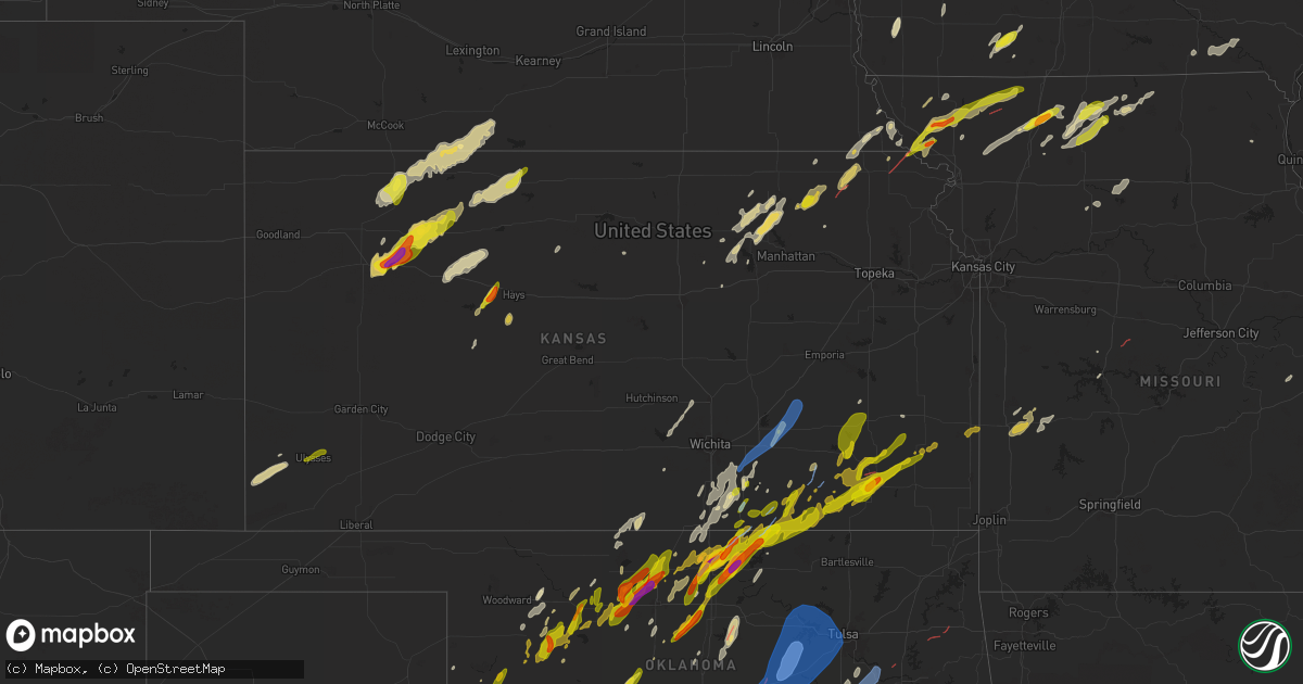
Hail Map in Kansas on April 27, 2024
Get this storm
April 27 map
$229
one time, instant access
Download today. No call, no setup
Keep the $229
Bought the map and want the full workflow? Apply the entire $229 to a subscription within 7 days. None of it is wasted.
Every map, not just this one
This buys you this map. Subscription and you get every map we run, in the markets you choose from a few cities to whole states to nationwide. Plus real-time alerts the moment a storm fires.
Contact data
Name, contact info, occupancy, even credit band for addresses in the footprint. You go from where it hit to who to call.
Become the source they trust
Unlimited branding weather history reports on demand. You already have the documented answer ready for the property owner, and you are the one who showed up with it.
Property data and RoofTrace estimates
Pull up any address you have got, its value and the exact code rules for that jurisdiction, straight from One Click Code. Then RoofTrace estimates the squares, pitch, and roof value, priced the way you price.
Storm reports in Kansas
Kansas
| Date | Description |
|---|---|
| 04/27/20246:52 PM CDT | A few reports of downed power lines and power outages. Time estimated from radar. |
| 04/27/20246:44 PM CDT | Downed power lines and power outages near windsor street. Time estimated from radar. |
| 04/27/20246:02 PM CDT | A local report indicates 1.00 inch wind near Yates Center |
| 04/27/20245:56 PM CDT | Delayed report brief tornado touchdown... Video included via facebook. |
| 04/27/20245:35 PM CDT | Very brief tornado. |
| 04/27/20245:31 PM CDT | Quarter sized hail and 55 mph winds reported. |
| 04/27/20245:27 PM CDT | A local report indicates 1.00 inch wind near 1 W New Albany |
| 04/27/20244:54 PM CDT | A local report indicates a tornado near 1 NW Longton |
| 04/27/20244:54 PM CDT | A local report indicates a tornado near Elk Falls |
| 04/27/20244:45 PM CDT | Trees uprooted. |
| 04/27/20244:42 PM CDT | Wedge tornado reported heading towards howard. |
| 04/27/20244:42 PM CDT | Multiple brief tornadoes just south of moline. Secondary rotation south of main tornado rotation area. |
| 04/27/20244:35 PM CDT | Gustnado report from 10 n kendall. Damaged outbuilding and power poles. Reported with picture and video. |
| 04/27/20244:35 PM CDT | [landspout] landspout report from 10 n kendall. Damaged outbuilding and power poles. Reported with picture and video. |
| 04/27/20244:35 PM CDT | Tornado report from 5 n kendall. Damaged outbuilding and power poles. Reported as tornado with picture and video. |
| 04/27/20244:35 PM CDT | Damaged outbuilding and power poles. Reported as tornado with picture but could be a tornado or landspout. |
| 04/27/20243:38 PM CDT | A local report indicates 1.00 inch wind near 2 N Dexter |
| 04/27/20243:31 PM CDT | Small tornado reported south of dexter. |
| 04/27/20243:03 PM CDT | A local report indicates 1.00 inch wind near Arkansas City |
| 04/27/20242:50 PM CDT | Tree damage to a line of trees with limbs torn off trees about 3 inch limbs reported from healthy trees. |
| 04/27/20242:47 PM CDT | Tornado reported by em. |
| 04/27/20242:30 PM CDT | Roof torn off a barn. Time estimated from radar. |
| 04/27/20242:15 PM CDT | A local report indicates a tornado near 2 WSW White Cloud |
| 04/27/20242:09 PM CDT | Confirmed tornado. |
| 04/27/20241:55 PM CDT | Delayed report. |
| 04/27/20241:55 PM CDT | Delayed report. |
| 04/27/20241:12 PM CDT | A local report indicates 1.00 inch wind near 5 NW Winfield |
| 04/27/20241:00 PM CDT | A local report indicates 60 MPH wind near Douglass |
| 04/26/202410:12 PM CDT | A local report indicates 1.00 inch wind near 1.5 E Petrolia |
| 04/26/20249:50 PM CDT | Tornado reported on the ground. |
| 04/26/20249:30 PM CDT | Quarter sized hail reported to dispatch at 930pm. |
| 04/26/20249:30 PM CDT | Quarter sized hail reported t |
| 04/26/20249:27 PM CDT | A local report indicates a tornado near 3 NW Neodesha |
| 04/26/20248:59 PM CDT | A local report indicates 1.00 inch wind near 7 N Arkansas City |
| 04/26/20248:58 PM CDT | A local report indicates 67 MPH wind near Strother Field Airport |
| 04/26/20248:30 PM CDT | A local report indicates 1.00 inch wind near 10 NNW Norton |
| 04/26/20248:24 PM CDT | Ks mesonet site 4sw of norton recorded a 61 mph gust. |
| 04/26/20248:14 PM CDT | A local report indicates 1.00 inch wind near Neodesha |
| 04/26/20248:12 PM CDT | A local report indicates 1.00 inch wind near Elk City |
| 04/26/20248:10 PM CDT | The public reported pea up to little larger than quarter sized hail east of tasco. |
| 04/26/20248:10 PM CDT | Delayed public report of silver dollar coin sized hail in studley. |
| 04/26/20248:04 PM CDT | A local report indicates 1.00 inch wind near 3 E Tasco |
| 04/26/20248:00 PM CDT | Estimated time of report. |
| 04/26/20247:56 PM CDT | A local report indicates 1.00 inch wind near 4 NE Ulysses |
| 04/26/20247:55 PM CDT | Video of a gustnado. |
| 04/26/20247:50 PM CDT | A local report indicates 1.00 inch wind near 1 WNW Ulysses |
| 04/26/20247:50 PM CDT | Downed power lines and power outages near showalter road. Time estimated from radar. |
| 04/26/20247:49 PM CDT | A local report indicates 1.00 inch wind near 2 W Ulysses |
| 04/26/20247:45 PM CDT | Em reports 1 inch diameter hail in heavy rain and winds gusting to 40 mph. |
| 04/26/20247:45 PM CDT | Delayed report. Received two separate photos of a tornado northeast of independence. Time and location estimated from radar. |
| 04/26/20247:42 PM CDT | A local report indicates 1.00 inch wind near 1 N Ulysses |
| 04/26/20247:41 PM CDT | A local report indicates 1.00 inch wind near Neodesha |
| 04/26/20247:40 PM CDT | Spotter report of 1 inch diameter hail near grainfield. Hail is starting to cover the ground. |
| 04/26/20247:39 PM CDT | Golf ball size hail. |
| 04/26/20247:33 PM CDT | A local report indicates 1.00 inch wind near 1 ESE Sycamore |
| 04/26/20247:32 PM CDT | Report from mping: hen egg |
| 04/26/20247:28 PM CDT | Golf ball and egg sized hail reported. |
| 04/26/20247:28 PM CDT | Corrects previous hail report from 3 e grinnell. Report from mping: hen egg |
All States Impacted by Hail Map on April 27, 2024
Cities Impacted by Hail Map on April 27, 2024
- Bono, AR
- Shamrock, TX
- Wellington, TX
- Lakeview, TX
- Cheyenne, OK
- Sayre, OK
- Sweetwater, OK
- Wheeler, TX
- Mclean, TX
- Quail, TX
- Reydon, OK
- Hammon, OK
- Leedey, OK
- Okeene, OK
- Longdale, OK
- Briscoe, TX
- Isabella, OK
- Fairview, OK
- Ringwood, OK
- Ames, OK
- Taloga, OK
- Camargo, OK
- Meno, OK
- Paducah, TX
- Vici, OK
- Durham, OK
- Goltry, OK
- Carrier, OK
- Lahoma, OK
- Enid, OK
- Nash, OK
- Kremlin, OK
- Pond Creek, OK
- Seiling, OK
- Chester, OK
- Mutual, OK
- Mooreland, OK
- Medford, OK
- Helena, OK
- Jet, OK
- Waynoka, OK
- Braman, OK
- Cleo Springs, OK
- Aline, OK
- Quanah, TX
- Wellington, KS
- Wakefield, KS
- Abilene, KS
- Crowell, TX
- Canton, OK
- Jayton, TX
- South Haven, KS
- Geuda Springs, KS
- Oxford, KS
- Erick, OK
- Oakwood, OK
- Longford, KS
- Belle Plaine, KS
- Carmen, OK
- Aspermont, TX
- Junction City, KS
- Cherokee, OK
- Mulvane, KS
- Clay Center, KS
- Amorita, OK
- Grandfield, OK
- Winfield, KS
- Udall, KS
- Riley, KS
- Rose Hill, KS
- Douglass, KS
- Eldorado, OK
- Butler, OK
- Rock, KS
- Randolph, KS
- Leonardville, KS
- Green, KS
- Onaga, KS
- Dawson, NE
- Sabetha, KS
- Bern, KS
- Olsburg, KS
- Old Glory, TX
- Dacoma, OK
- Atlanta, KS
- Leon, KS
- Duke, OK
- Blue Rapids, KS
- Greenleaf, KS
- Elk City, OK
- Augusta, KS
- Altus, OK
- Blair, OK
- El Dorado, KS
- Rosalia, KS
- Eureka, KS
- Fairmont, OK
- Westmoreland, KS
- Hiawatha, KS
- Garber, OK
- Douglas, OK
- Barnes, KS
- Salem, NE
- Verdon, NE
- Seymour, TX
- Palmer, KS
- Hunter, OK
- Frankfort, KS
- White Cloud, KS
- Fairfax, MO
- Vermillion, KS
- Barnard, KS
- Mangum, OK
- Olustee, OK
- Lamont, OK
- Covington, OK
- Nardin, OK
- Axtell, KS
- Billings, OK
- Tonkawa, OK
- Lone Wolf, OK
- Skidmore, MO
- Caldwell, KS
- O'Brien, TX
- Craig, MO
- Centralia, KS
- Waterville, KS
- Falls City, NE
- Deer Creek, OK
- Knox City, TX
- Guthrie, OK
- Blackwell, OK
- Ponca City, OK
- Hobart, OK
- Corning, KS
- Goff, KS
- Brownell, KS
- La Crosse, KS
- Burlington Junction, MO
- Clearfield, IA
- Benton, IA
- Blockton, IA
- Diagonal, IA
- Mound City, MO
- Forest City, MO
- Bison, KS
- Wakita, OK
- Newkirk, OK
- Arkansas City, KS
- Vernon, TX
- Hays, KS
- Rock Port, MO
- Rulo, NE
- Maitland, MO
- Oneida, KS
- Seneca, KS
- Bazine, KS
- McCracken, KS
- Shannon City, IA
- Schoenchen, KS
- Liebenthal, KS
- Ransom, KS
- Ellis, KS
- Graham, MO
- Coyle, OK
- Perry, OK
- Two Buttes, CO
- Sentinel, OK
- Rocky, OK
- Cordell, OK
- Barnard, MO
- Maryville, MO
- Fairview, KS
- Stillwater, OK
- Walsh, CO
- Lenox, IA
- Knoxville, IA
- Victoria, KS
- Peck, KS
- Munday, TX
- Mountain View, OK
- Dexter, KS
- Conception Junction, MO
- Electra, TX
- Pleasantville, IA
- Otley, IA
- Imogene, IA
- Ridott, IL
- Freeport, IL
- Dakota, IL
- Morrison, OK
- Maple City, KS
- Morrill, KS
- Baileyville, KS
- Oregon, MO
- Carnegie, OK
- Ravenwood, MO
- Hydro, OK
- Cambridge, KS
- Pella, IA
- Randolph, IA
- Emerson, IA
- Malvern, IA
- Hastings, IA
- Sully, IA
- Marland, OK
- New Virginia, IA
- Gorham, KS
- Rock City, IL
- Afton, IA
- Natoma, KS
- Mayfield, KS
- Bolckow, MO
- Colony, OK
- Corn, OK
- Monroe, IA
- Reasnor, IA
- Indianola, IA
- Lookeba, OK
- Hinton, OK
- Harrold, TX
- Paradise, KS
- Weatherford, OK
- Milo, IA
- Ackworth, IA
- Oklaunion, TX
- Villisca, IA
- Elliott, IA
- Clyde, MO
- Goree, TX
- Davidson, OK
- Lynnville, IA
- Searsboro, IA
- Grinnell, IA
- Cedar Vale, KS
- Stanberry, MO
- Gentry, MO
- Sheridan, MO
- Conception, MO
- Worth, MO
- Parnell, MO
- Lewis, IA
- Waukomis, OK
- Cumberland, IA
- Bison, OK
- Atlantic, IA
- Waldo, KS
- Geary, OK
- Montezuma, IA
- Grant City, MO
- Denver, MO
- Hatfield, MO
- Martinsville, MO
- Calumet, OK
- Grenola, KS
- Hollister, OK
- Loveland, OK
- Frederick, OK
- Shidler, OK
- Wiota, IA
- King City, MO
- Union Star, MO
- Moline, KS
- Howard, KS
- Okarche, OK
- McFall, MO
- Epworth, IA
- Farley, IA
- Dyersville, IA
- Albany, MO
- Center Point, IA
- Walker, IA
- Newton, IA
- Malcom, IA
- Durango, IA
- Dubuque, IA
- Sherrill, IA
- Kingfisher, OK
- Kaw City, OK
- Mount Ayr, IA
- Gilman City, MO
- Trenton, MO
- Coggon, IA
- Ridgeway, MO
- Eagleville, MO
- Pattonsburg, MO
- Princeton, MO
- Bethany, MO
- Spickard, MO
- Elk Falls, KS
- Cuba City, WI
- Hazel Green, WI
- Potosi, WI
- Kieler, WI
- Platteville, WI
- Rochester, TX
- Rule, TX
- Ryan, IA
- New Hampton, MO
- Jameson, MO
- Cambridge, WI
- Deerfield, WI
- Hennessey, OK
- Watonga, OK
- Dover, OK
- Deep River, IA
- Brooklyn, IA
- Guernsey, IA
- Severy, KS
- Indiahoma, OK
- Newtown, MO
- Victor, IA
- Ladora, IA
- Delhi, IA
- Fall River, KS
- Longton, KS
- Manchester, IA
- Johnson Creek, WI
- Lake Mills, WI
- Watertown, WI
- Waterloo, WI
- Fredonia, KS
- Toronto, KS
- Virgil, KS
- Yates Center, KS
- Marshall, OK
- Neosho, WI
- Holy Cross, IA
- Belmont, WI
- Darlington, WI
- Shullsburg, WI
- Marengo, IA
- Lucien, OK
- Sedan, KS
- Coffey, MO
- Lucerne, MO
- Mulhall, OK
- Orlando, OK
- Buffalo, KS
- Lebanon, WI
- Jamesport, MO
- Rubicon, WI
- Iowa Park, TX
- Harris, MO
- Benedict, KS
- Hamlin, TX
- Argyle, WI
- Worthington, IA
- Earlville, IA
- Roby, TX
- Pollock, MO
- Pawhuska, OK
- Galt, MO
- Hustisford, WI
- Milan, MO
- Red Rock, OK
- Sweetwater, TX
- Hermleigh, TX
- Blanchardville, WI
- Rotan, TX
- Peru, KS
- Laredo, MO
- Hale, MO
- Tina, MO
- Chanute, KS
- Humboldt, KS
- Burkburnett, TX
- Chautauqua, KS
- Unionville, MO
- Holliday, TX
- Madison, WI
- Monticello, WI
- La Harpe, KS
- Monroe, WI
- Sheboygan Falls, WI
- Sheboygan, WI
- Janesville, IA
- Cedar Falls, IA
- Denver, IA
- New Vienna, IA
- Iola, KS
- Devol, OK
- Havana, KS
- Elk City, KS
- Randlett, OK
- New Glarus, WI
- Walters, OK
- Black Earth, WI
- Cross Plains, WI
- Dane, WI
- Waunakee, WI
- Middleton, WI
- Lodi, WI
- Green City, MO
- Bucyrus, KS
- Altoona, KS
- Waverly, IA
- Tripoli, IA
- Sumner, IA
- Readlyn, IA
- Crawford, OK
- Sumner, MO
- Owensville, MO
- Cuba, MO
- Moran, KS
- Independence, KS
- Kohler, WI
- Rogers City, MI
- North English, IA
- Elkhart, KS
- Deforest, WI
- Neodesha, KS
- Waucoma, IA
- Hawkeye, IA
- Fredericksburg, IA
- Laclede, MO
- Bronson, KS
- Kincaid, KS
- Marshall, WI
- Meadville, MO
- Bogard, MO
- Johnson, KS
- Grinnell, KS
- Selden, KS
- Oberlin, KS
- Erie, KS
- Arlington, WI
- Morrisonville, WI
- Bloomfield, IA
- Albany, WI
- Rio, WI
- Snyder, TX
- Temple, OK
- Wichita Falls, TX
- Brookfield, MO
- Savonburg, KS
- Niotaze, KS
- Poynette, WI
- Columbus, WI
- Fall River, WI
- Hoxie, KS
- Grainfield, KS
- Thompsonville, MI
- Copemish, MI
- Kingsley, MI
- Fife Lake, MI
- Oakley, KS
- Stark, KS
- Thayer, KS
- Milton, IA
- Douds, IA
- Comanche, OK
- Elsmore, KS
- Floris, IA
- Duncan, OK
- Geronimo, OK
- Cherryvale, KS
- Randolph, WI
- Beaver Dam, WI
- Dresden, KS
- Weinert, TX
- Hollandale, WI
- Mount Horeb, WI
- South Boardman, MI
- Juneau, WI
- Iron Ridge, WI
- Uniontown, KS
- Sheppard Afb, TX
- Reeseville, WI
- Burnett, WI
- Belleville, WI
- Marlow, OK
- Waupun, WI
- Ulysses, KS
- Norcatur, KS
- Redfield, KS
- Manistee, MI
- Onekama, MI
- Verona, WI
- Morland, KS
- Brooklyn, WI
- Sharon, OK
- Bear Lake, MI
- Roscoe, TX
- Maryneal, TX
- Oregon, WI
- Penokee, KS
- Hill City, KS
- Galesburg, KS
- Waurika, OK
- Rush Springs, OK
- Norton, KS
- Brethren, MI
- Kaleva, MI
- Bradley, OK
- Lawton, OK
- Mineral Point, WI
- Loraine, TX
- Haskell, TX
- Coahoma, TX
- Westbrook, TX
- Big Spring, TX
- Saint Paul, KS
- Ninnekah, OK
- Lindsay, OK
- Kingston, OK
- Gordonville, TX
- Alex, OK
- Blanchard, OK
- Fort Scott, KS
- Madill, OK
- Wilsonville, NE
- Hendley, NE
- Hepler, KS
- Mannsville, OK
- Tishomingo, OK
- Wilson, OK
- Lenora, KS
- Ringling, OK
- Beaver City, NE
- Collyer, KS
- Wakeeney, KS
- Medicine Lodge, KS
- Colorado City, TX
- Walnut, KS
- Kalkaska, MI
- Healdton, OK
- Saint Jo, TX
- Muenster, TX
- Purcell, OK
- Washington, OK
- Deerfield, MO
- Buckley, MI
- Ardmore, OK
- Springer, OK
- Mill Creek, OK
- Ludington, MI
- Free Soil, MI
- Mancelona, MI
- Richards, MO
- Prairie View, KS
- Logan, KS
- Midland, TX
- Oxford, NE
- Stamford, NE
- Grayling, MI
- Elmore City, OK
- Pauls Valley, OK
- Burden, KS
- Hennepin, OK
- McCamey, TX
- Mechanicsburg, IL
- Buffalo, IL
- Norman, OK
- Waverly, NE
- Ceresco, NE
- Palco, KS
- Ogallah, KS
- Phillipsburg, KS
- Garden City, TX
- Midkiff, TX
- Ozona, TX
- Ithaca, NE
- Wahoo, NE
- Glade, KS
- Greenwood, NE
- Ashland, NE
- Paoli, OK
- Graham, OK
- Noble, OK
- Ratliff City, OK
- Iraan, TX
- Bessie, OK
- Apache, OK
- Fletcher, OK
- Foss, OK
- Elgin, OK
- Oklahoma City, OK
- Maysville, OK
- Stonewall, OK
- Roff, OK
- Waldron, KS
- Piedmont, KS
- Plainville, KS
- Lexington, OK
- Throckmorton, TX
- Walker, MO
- El Dorado Springs, MO
- Harwood, MO
- Choctaw, OK
- Farlington, KS
- Harrah, OK
- Davis, OK
- Garland, KS
- Whitewater, WI
- Chestnut, IL
- Schell City, MO
- Fort Stockton, TX
- Rankin, TX
- Arcadia, KS
- Bronaugh, MO
- Wynnewood, OK
- Manchester, OK
- Anthony, KS
- Almena, KS
- Newcastle, OK
- Dougherty, OK
- Sulphur, OK
- Burneyville, OK
- Overbrook, OK
- Ada, OK
- Nevada, MO
- Moundville, MO
- Lone Grove, OK
- Elkhorn, WI
- Allen, OK
- Latham, KS
- Orleans, NE
- Chandler, OK
- Milan, KS
- Holdenville, OK
- Sasakwa, OK
- Waukesha, WI
- Meeker, OK
- Sparks, OK
- Sedalia, MO
- Big Lake, TX
- Stamford, TX
- Lewistown, MO
- La Belle, MO
- Davenport, OK
- Stroud, OK
- Hastings, OK
- Anson, TX
- Sylvester, TX
- McCaulley, TX
- Olney, TX
- Newcastle, TX
- Norwich, KS
- Milton, KS
- Milo, MO
- Byers, TX
- Avoca, TX
- Sterling City, TX
- Gainesville, TX
- Wewoka, OK
- Trent, TX
- Wetumka, OK
- Okemah, OK
- Marietta, OK
- Cole Camp, MO
- Mora, MO
- Merkel, TX
- Robert Lee, TX
- Petrolia, TX
- Windsor, MO
- Lincoln, MO
- Cushing, OK
- Depew, OK
- Bristow, OK
- Paden, OK
- Prague, OK
- Cleveland, OK
- Jennings, OK
- Yale, OK
- Drumright, OK
- Mannford, OK
- Kellyville, OK
- Terlton, OK
- Hominy, OK
- Osage, OK
- Sapulpa, OK
- Sand Springs, OK
- Prue, OK
- Skiatook, OK
- Tulsa, OK
- Loco, OK
- Blackwell, TX
- Warsaw, MO
- Lueders, TX
- Barnhart, TX
- Hawley, TX
- Castle, OK
- Windthorst, TX
- Henrietta, TX
- Abilene, TX
- Osceola, MO
- Tye, TX
- Fitzhugh, OK
- Bellevue, TX
- Bronte, TX
- Tuscola, TX
- Wingate, TX
- Fittstown, OK
- Norton, TX
- Winters, TX
- Henryetta, OK
- Okmulgee, OK
- Morris, OK
- Albany, TX
- Eldorado, TX
- Woodson, TX
- Beggs, OK
- Calvin, OK
- Ovalo, TX
- Buffalo Gap, TX
- Weleetka, OK
- Dyess Afb, TX
- Haskell, OK
- Boynton, OK
- Mounds, OK
- Nocona, TX
- Clyde, TX
- Lawn, TX
- San Angelo, TX
- Porter, OK
- Coweta, OK
- Mcalester, OK
- Lamar, OK
- Moran, TX
- Graham, TX
- Breckenridge, TX
- Bixby, OK
- Atwood, OK
- Hanna, OK
- Dustin, OK
- Bowie, TX
- Baird, TX
- Jacksboro, TX
- Ballinger, TX
- Eufaula, OK
- Rowena, TX
- Cisco, TX
- Miles, TX
- Comstock, TX
- Stuart, OK
- Cross Plains, TX
- Ranger, TX
- Paint Rock, TX
- Peggs, OK
- Locust Grove, OK
- Eastland, TX
- Rose, OK
- Alvord, TX
- Sonora, TX
- Burlington, OK
- Burbank, OK
- Voss, TX
- Decatur, TX
- Millersview, TX
- Doole, TX
- Brownwood, TX
- Santa Anna, TX
- Coleman, TX
- Gouldbusk, TX
- Guilford, MO
- Junction, TX
- Roosevelt, TX
- Valera, TX
- Mount Hope, KS
- Rocksprings, TX
- Del Rio, TX
- Burrton, KS
- Haven, KS
- Blanket, TX
- Early, TX
- Halstead, KS
- Comanche, TX
- Sedgwick, KS
- Zephyr, TX
- Mullin, TX
- Gustine, TX
- Dublin, TX
- Roland, OK
- Muldrow, OK
- Van Buren, AR
- San Saba, TX
- Fort Smith, AR
- Brackettville, TX
- Arkoma, OK
- Pickering, MO
- Keosauqua, IA
- Birmingham, IA
- Butler, MO
- Urich, MO
- Montrose, MO
- Clinton, MO
- Clarksburg, MO
- Wagoner, OK


