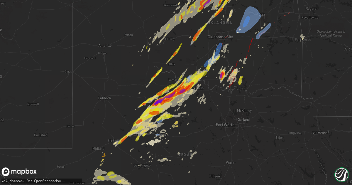
Hail Map on April 27, 2024
Get this storm
April 27 map
$229
one time, instant access
Download today. No call, no setup
Keep the $229
Bought the map and want the full workflow? Apply the entire $229 to a subscription within 7 days. None of it is wasted.
Every map, not just this one
This buys you this map. Subscription and you get every map we run, in the markets you choose from a few cities to whole states to nationwide. Plus real-time alerts the moment a storm fires.
Contact data
Name, contact info, occupancy, even credit band for addresses in the footprint. You go from where it hit to who to call.
Become the source they trust
Unlimited branding weather history reports on demand. You already have the documented answer ready for the property owner, and you are the one who showed up with it.
Property data and RoofTrace estimates
Pull up any address you have got, its value and the exact code rules for that jurisdiction, straight from One Click Code. Then RoofTrace estimates the squares, pitch, and roof value, priced the way you price.
States Impacted by Hail Map on April 27, 2024
Storm reports
Oklahoma
| Date | Description |
|---|---|
| 04/27/20246:54 PM CDT | Visual cone tornado reported buried in precip. ( |
| 04/27/20246:54 PM CDT | Visual cone tornado reported buried in precip. |
| 04/27/20246:40 PM CDT | A local report indicates 60 MPH wind near 2 W Grandfield |
| 04/27/20246:20 PM CDT | A local report indicates 1.00 inch wind near 3 W Ceres |
| 04/27/20246:05 PM CDT | A local report indicates 1.00 inch wind near 5 SW Grandfield |
| 04/27/20245:48 PM CDT | Nwschat report. |
| 04/27/20244:54 PM CDT | Report from mping... Time is radar estimated. |
| 04/27/20244:30 PM CDT | Damage also reported about 4 miles nnw of calumet. |
| 04/27/20243:27 PM CDT | 1 mile west of us-177... 1 mile south of noble county line. |
| 04/27/20243:17 PM CDT | Report from mping... Time is radar estimated. |
| 04/27/20243:17 PM CDT | Report from mping... Time is radar estimated. |
| 04/27/20242:42 PM CDT | Multiple twitter photos. |
| 04/27/20242:41 PM CDT | Report from mping... Time is radar estimated. |
| 04/27/20242:40 PM CDT | Report from mping. |
| 04/27/20242:39 PM CDT | Report from mping. |
| 04/27/20242:38 PM CDT | Report from mping... Time is radar estimated. |
| 04/27/20242:35 PM CDT | Report from mping. |
| 04/27/20242:35 PM CDT | Report from mping. |
| 04/27/20242:32 PM CDT | Report from mping... Time is radar estimated. |
| 04/27/20241:21 PM CDT | Buildings and trees damaged. |
| 04/27/20241:06 PM CDT | A local report indicates 1.00 inch wind near 6 SW Eldorado |
| 04/27/202411:19 AM CDT | A local report indicates 1.75 inch wind near 3 SW Seiling |
| 04/27/202411:19 AM CDT | A local report indicates 1.75 inch wind near 3 SSW Seiling |
| 04/27/202411:19 AM CDT | A local report indicates 1.75 inch wind near 3 SW Seiling |
| 04/27/202411:08 AM CDT | Report from mping: half dollar |
| 04/27/20241:37 AM CDT | Tornado brought down trees at hwy 412 alt and 540 road |
| 04/27/20241:27 AM CDT | Tds observed on radar; time estimated by radar. |
| 04/27/20241:25 AM CDT | Wind damage report from mping; time estimated by radar. |
| 04/27/20241:22 AM CDT | Wind damage report from m-ping; time estimated by radar. |
| 04/27/20241:21 AM CDT | Wind damage report from mping; 3 inch tree limbs snapped; time estimated by radar. |
| 04/27/202412:59 AM CDT | Tds observed on radar; time estimated by radar. |
| 04/27/202412:58 AM CDT | Power poles down 1/4 mi south of hwy 51 and hwy 69 junction in wagoner; time estimated by radar. |
| 04/27/202412:45 AM CDT | A local report indicates 70 MPH wind near 2.5 W Clarksville |
| 04/27/202412:35 AM CDT | A local report indicates 64 MPH wind near 5 SSE Haskell |
| 04/27/202412:26 AM CDT | 2 inch diameter tree limb fell; time estimated by radar. |
| 04/27/202412:12 AM CDT | A local report indicates a tornado near Morris |
| 04/27/202412:11 AM CDT | Quite a bit of tree damage...power lines down...minor structural damage...time estimated by radar. |
| 04/27/202412:10 AM CDT | A local report indicates 72 MPH wind near Okmulgee |
| 04/27/202412:08 AM CDT | Wind damage report from mping; 1-2 inch tree limbs snapped; time estimated by radar. |
| 04/27/202412:05 AM CDT | A local report indicates 59 MPH wind near Foraker |
| 04/27/202412:00 AM CDT | 3-inch tree limbs broken; power poles broken; from mping; time estimated by radar. |
| 04/26/202411:27 PM CDT | Wind damage report from mping...time estimated by radar as circulation passed over. |
| 04/26/202411:15 PM CDT | Tree damage; time estimated by radar. |
| 04/26/202411:10 PM CDT | Extensive damage to buildings and trees reported in marietta. |
| 04/26/202411:07 PM CDT | House heavily damaged 2.5 miles east of hwy 48; time estimated by radar. |
| 04/26/202411:04 PM CDT | Tds observed entering okfuskee county; time estimated by radar. |
| 04/26/202411:00 PM CDT | Hwy 33 & 99. |
| 04/26/202410:56 PM CDT | Strong winds blew roof off a building in drumright. |
| 04/26/202410:39 PM CDT | Large tds impacting western holdenville... With widespread damage reported. |
| 04/26/202410:39 PM CDT | *** 1 fatal *** large tds impacting near spaulding... Western holdenville and areas north of holdenville. Widespread damage reported. |
| 04/26/202410:38 PM CDT | A local report indicates a tornado near 6 SSE Francis |
| 04/26/202410:24 PM CDT | Noticeable tds as tornado moved through town. Widespread damage reported across sulphur. |
| 04/26/20249:57 PM CDT | Twitter photo as tornado moved through ardmore. |
| 04/26/20249:42 PM CDT | Nwschat report. |
| 04/26/20249:35 PM CDT | A local report indicates 59 MPH wind near 2 NW Norman |
| 04/26/20249:28 PM CDT | Notable damage at homeland; strong radar signature matches at this time; additional damage around norman. |
| 04/26/20249:20 PM CDT | Tornado debris signature on radar. |
| 04/26/20249:10 PM CDT | Corrects previous hail report from fox for time to be radar estimate. Nwschat report. |
| 04/26/20249:00 PM CDT | Report from mping... Time is radar estimated. |
| 04/26/20248:57 PM CDT | Report from mping. |
| 04/26/20248:53 PM CDT | Tornado debris signature on radar. |
| 04/26/20248:43 PM CDT | Report from mping. |
| 04/26/20248:20 PM CDT | Delayed report...radar confirmed tds... One of two in close proximity. |
| 04/26/20248:03 PM CDT | Nwschat report. |
| 04/26/20247:41 PM CDT | Picture on twitter. |
| 04/26/20247:39 PM CDT | Nwschat relayed report. |
| 04/26/20247:35 PM CDT | Picture on broadcast tv with measurement... Time is radar estimated. |
| 04/26/20247:26 PM CDT | Report from mping... Time is radar estimated. |
| 04/26/20247:26 PM CDT | A local report indicates 1.00 inch wind near 16 WSW Apperson |
| 04/26/20247:11 PM CDT | Report from mping. |
Arkansas
| Date | Description |
|---|---|
| 04/27/20242:15 AM CDT | Large trees down. |
Texas
| Date | Description |
|---|---|
| 04/27/20246:57 PM CDT | Report from mping: quarter |
| 04/27/20246:52 PM CDT | A local report indicates 1.00 inch wind near 6 WNW Iowa Park |
| 04/27/20246:51 PM CDT | Report from mping... Time is radar estimated. |
| 04/27/20246:35 PM CDT | A local report indicates 78 MPH wind near 4 W Rotan |
| 04/27/20245:47 PM CDT | Report from mping. |
| 04/27/20245:44 PM CDT | Report from mping. |
| 04/27/20245:34 PM CDT | Report from mping. |
| 04/27/20245:23 PM CDT | A local report indicates 1.50 inch wind near Electra |
| 04/27/20244:13 PM CDT | Report from mping... Time is radar estimated. |
| 04/27/20244:08 PM CDT | Delayed report tornado first sighted about 6-8 miles west of seymour along sh114/us82 at 408pm... Moved northeast and roped out near lake kemp at 440pm. |
| 04/27/20243:10 PM CDT | A local report indicates 59 MPH wind near 3 NW Knox City |
| 04/27/20243:06 PM CDT | Tornado at fm 222 and 1292. |
| 04/27/20242:47 PM CDT | A local report indicates 2.75 inch wind near 5 W Knox City |
| 04/27/20242:33 PM CDT | Delayed twitter report. |
| 04/27/202412:49 PM CDT | A local report indicates 1.25 inch wind near 2 E Goodlett |
| 04/27/202412:21 AM CDT | Nickel to quarter sized hail reported. Time estimated by radar. |
| 04/26/202411:34 PM CDT | Corrected non thunderstorm wind gust to thunderstorm wind gust. |
| 04/26/202411:30 PM CDT | Nickel to quarter sized hail reported. Time estimated by radar. |
| 04/26/202410:58 PM CDT | Mesonet station 102 5ese stamford stamford/jones county. |
| 04/26/202410:55 PM CDT | Corrects previous hail report from stamford. |
| 04/26/20249:24 PM CDT | Report from mping: quarter |
| 04/26/20249:14 PM CDT | Report from mping: quarter |
| 04/26/20249:11 PM CDT | Report from mping: quarter |
| 04/26/20248:55 PM CDT | Sherriff's office |
| 04/26/20248:50 PM CDT | Nwschat report. |
| 04/26/20248:18 PM CDT | Nwschat report. |
| 04/26/20248:18 PM CDT | Photo posted on facebook. |
| 04/26/20248:17 PM CDT | Report from mping: quarter |
| 04/26/20248:06 PM CDT | A local report indicates 1.00 inch wind near Rotan |
| 04/26/20248:00 PM CDT | A local report indicates 1.75 inch wind near Rotan |
| 04/26/20247:55 PM CDT | Report from mping: quarter |
| 04/26/20247:52 PM CDT | Report from mping: half dollar |
| 04/26/20247:19 PM CDT | Report from mping. |
| 04/26/20247:15 PM CDT | Report from mping: half dollar |
| 04/26/20247:09 PM CDT | Nwschat report. |
| 04/26/20247:04 PM CDT | Updated report. |
Missouri
| Date | Description |
|---|---|
| 04/27/20246:40 PM CDT | Brief touchdown west of brookfield. Time estimated from radar. |
| 04/27/20246:34 PM CDT | 1 inch hail reported near osgood. Time estimate via radar. |
| 04/27/20246:02 PM CDT | Quarter-sized hail reported by emergency manager. |
| 04/27/20245:41 PM CDT | 1 inch hail reported by emergency manager. |
| 04/27/20245:09 PM CDT | Social media report of quarter size hail near bethany. Time and location estimated from social media report and radar. |
| 04/27/20245:02 PM CDT | Report from mping: ping pong ball |
| 04/27/20245:00 PM CDT | Social media report of half dollar size hail in bethany. Time estimated from radar. |
| 04/27/20244:58 PM CDT | A weak ef0 tornado began southeast of spickard east of 7th avenue... Producing sporadic and intermittent tree damage along its path. The tornado tracked north-northeast |
| 04/27/20244:19 PM CDT | Missouri highway police reported tornado crossing hwy 169. |
| 04/27/20244:13 PM CDT | Metal roof torn off residence. Metal in trees and some 4-6 inch limbs down. Time estimated via radar. |
| 04/27/20244:12 PM CDT | This ef1 tornado began near or just west of u.s. Highway 169 south of gentry... Where a tractor trailer was blown over. Little damage was observed as the tornado moved |
| 04/27/20244:10 PM CDT | Report from mping: golf ball |
| 04/27/20244:08 PM CDT | Powerlines down; outages reported. |
| 04/27/20243:54 PM CDT | Media partner reported quarter-sized hail just south of ravenwood... Mo along 136-hwy. |
| 04/27/20243:17 PM CDT | Social media report of half dollar size near maryville. Time estimated from radar. |
| 04/27/20243:00 PM CDT | Golf ball-sized hail along hwy 113 at 3pm. |
| 04/27/20242:30 PM CDT | Corrects previous hail report from corning. Mping report of half dollar size hail. |
| 04/27/20241:35 PM CDT | Mping report. |
| 04/27/20244:37 AM CDT | Photos via facebook - show trampoline damage... 5 small trees uprooted... Multiple trees/large tree branches snapped. |
| 04/27/20243:30 AM CDT | Numerous trees uprooted. |
| 04/27/20243:12 AM CDT | Photos from facebook. Tree split and another broke in half. |
| 04/27/20242:12 AM CDT | Facebook comment with photo - large tree limbs down... South of el dorado springs... 5 miles down hwy u. |
| 04/27/20241:05 AM CDT | Medium tree uprooted. Time estimated from radar. |
| 04/26/202411:02 PM CDT | Damage to metal outbuilding. Time estimated from radar. |
| 04/26/202411:02 PM CDT | Photos show a mobile home was rolled off of its foundation and crushed. Time estimated from radar. |
| 04/26/202411:02 PM CDT | Corrects previous tstm wnd dmg report from 1 n tipton. Three utility poles snapped just northeast of tipton along alexander rd. Time estimated from radar. |
| 04/26/202410:59 PM CDT | An ef1 tornado formed shortly before 11pm on the 27th northeast of tipton... Mo along alexander rd... Causing damage to both structures and trees before dissipating a m |
| 04/26/202410:59 PM CDT | Scattered reports of power outages throughout cooper county. Time estimated from radar. |
| 04/26/202410:59 PM CDT | Three utility poles snapped just north of tipton. Time estimated from radar. |
| 04/26/202410:30 PM CDT | Delayed report. Report from mping. 1-inch tree limbs broken... Shingles blown off. Time based on radar. |
| 04/26/202410:29 PM CDT | Trees were uprooted along ehlers and butterfield trail road to the southwest of florence during a tornado saturday evening. The tornado had max winds of 75 mph with a w |
| 04/26/202410:17 PM CDT | Delayed report. Report of an irrigation arm turned upside down and tree damage from the thunderstorms. Measured peak thunderstorm wind gust of 61 mph relayed from a coo |
| 04/26/202410:12 PM CDT | Delayed report. 5 trees uprooted... Multiple trees snapped in half or with missing limbs. |
| 04/26/202410:05 PM CDT | Downed power lines and power outages near quisenberry road. Time estimated from radar. |
| 04/26/20249:20 PM CDT | Downed power lines and power outages near 251st road. Time estimated from radar. |
| 04/26/20249:17 PM CDT | Downed power lines and power outages near 950 road. Time estimated from radar. |
| 04/26/20248:48 PM CDT | Power flashes reported 3 miles north of montrose with visible funnel. |
| 04/26/20248:46 PM CDT | Multiple 5-6 inch diameter tree limbs downed east of creighton. Timing estimated by radar. |
| 04/26/20248:45 PM CDT | A brief ef0 tornado occurred north of montrose from the same mesovortex that produced the tornado just southeast of butler. The first signs of damage occurred just west |
| 04/26/20248:44 PM CDT | Downed power lines and power outages near nw 100 rd. Time estimated from radar. |
| 04/26/20248:37 PM CDT | Several reports of power outages east of adrian. Time estimated from radar. |
| 04/26/20248:30 PM CDT | This ef1 tornado began just south of route 18 east of passaic. Some of the worst damage of the tornado affected a farm property... Where one outbuilding collapsed... An |
| 04/26/20248:26 PM CDT | Downed power lines and power outages near route e. Time estimated from radar. |
| 04/26/20248:23 PM CDT | This ef1 tornado began just east of route yy and just south of state highway 52 southeast of butler in bates county... Where minor tree damage was observed. The tornado |
| 04/26/20248:19 PM CDT | Downed power lines and power outages near route 52. Time estimated from radar. |
| 04/26/20248:15 PM CDT | Downed power lines and power outages near route pp. Time estimated from radar. |
| 04/26/20248:04 PM CDT | Sherriffs office reported power lines downed along hwy a near rich hill. Location estimated; timing estimated via radar. |
| 04/26/20248:00 PM CDT | Delayed social media report of multiple trees down on and near route u. Time estimated from radar. |
| 04/26/20247:14 PM CDT | Also observed minor ponding. Relayed via social media. |
| 04/26/20247:09 PM CDT | Downed power lines and power outages near 137th street. Time estimated from radar. |
| 04/26/20247:07 PM CDT | Downed power lines and power outages near silver lane. Time estimated from radar. |
| 04/26/20247:07 PM CDT | Downed power lines and power outages near summit road. Time based on dispatch report and confirmed from radar. |
| 04/26/20247:07 PM CDT | Downed power lines and power outages near 195th street. Time estimated from radar. |
| 04/26/20247:03 PM CDT | Downed power lines and power outages near westover road. Time estimated from radar. |
Nebraska
| Date | Description |
|---|---|
| 04/27/20243:02 PM CDT | Delayed report from 4/26. |
Illinois
| Date | Description |
|---|---|
| 04/26/20249:25 PM CDT | A large tree branch was blown down. |
Iowa
| Date | Description |
|---|---|
| 04/27/20246:26 PM CDT | Reports of trees and branches down. Time estimated via radar. |
| 04/27/20246:26 PM CDT | Reports of large trees down and power outages in town. Time estimated via radar. |
| 04/27/20246:26 PM CDT | Reports of trees and branches down. Tim |
| 04/27/20246:15 PM CDT | Via mping report. |
| 04/27/20246:08 PM CDT | Power pole and lines down on hwy 5 1.5 miles north of town. |
| 04/27/20245:22 PM CDT | Dime... Nickel... And quarter ground covered. |
| 04/27/20244:53 PM CDT | Report relayed by media. Time estimated using radar. |
| 04/27/20244:00 PM CDT | Delayed report. Exact location not provided... Only town was given. |
| 04/27/20243:57 PM CDT | Quarter sized hail near sully. |
| 04/26/20248:07 PM CDT | Delayed report. Time estimated from radar. |
| 04/26/20248:03 PM CDT | Large tree downed on a vehicle. Relayed by dispatch. |
| 04/26/20247:40 PM CDT | Also had some small tree branches down. Time estimated from radar. |
| 04/26/20247:10 PM CDT | Delayed social media report of a 70 mph wind gust measured in keota. Time estimated from radar. |
| 04/26/20247:00 PM CDT | Several tree branches of various size down in north english. Time estimated from radar. |
Michigan
| Date | Description |
|---|---|
| 04/26/20248:46 PM CDT | Photo from social media. |
| 04/26/20248:30 PM CDT | Quarter sized hail near m66 and prairie ln. |
| 04/26/20248:25 PM CDT | A local report indicates 1.00 inch wind near Kingsley |
| 04/26/20248:25 PM CDT | Quarter sized hail at the intersection of m113 and m186. Time estimated by radar. |
| 04/26/20248:16 PM CDT | Corrects time on previous hail report from 1 ese onekama. Photo from social media. |
| 04/26/20248:15 PM CDT | Image of near inch sized hail on a deck. |
| 04/26/20248:15 PM CDT | A local report indicates 1.00 inch wind near 2 SW Onekama |
| 04/26/20248:15 PM CDT | Images shared on social media from zosel st. In onekama of measured 2 inch hail. Damage to vehicles and home siding. Time estimated from radar. |
| 04/26/20247:56 PM CDT | Report from mping: quarter |
| 04/26/20247:50 PM CDT | Image on social media with ruler showing at least 1.5 inch hail. |
Kansas
| Date | Description |
|---|---|
| 04/27/20246:52 PM CDT | A few reports of downed power lines and power outages. Time estimated from radar. |
| 04/27/20246:44 PM CDT | Downed power lines and power outages near windsor street. Time estimated from radar. |
| 04/27/20246:02 PM CDT | A local report indicates 1.00 inch wind near Yates Center |
| 04/27/20245:56 PM CDT | Delayed report brief tornado touchdown... Video included via facebook. |
| 04/27/20245:35 PM CDT | Very brief tornado. |
| 04/27/20245:31 PM CDT | Quarter sized hail and 55 mph winds reported. |
| 04/27/20245:27 PM CDT | A local report indicates 1.00 inch wind near 1 W New Albany |
| 04/27/20244:54 PM CDT | A local report indicates a tornado near Elk Falls |
| 04/27/20244:54 PM CDT | A local report indicates a tornado near 1 NW Longton |
| 04/27/20244:45 PM CDT | Trees uprooted. |
| 04/27/20244:42 PM CDT | Wedge tornado reported heading towards howard. |
| 04/27/20244:42 PM CDT | Multiple brief tornadoes just south of moline. Secondary rotation south of main tornado rotation area. |
| 04/27/20244:35 PM CDT | Damaged outbuilding and power poles. Reported as tornado with picture but could be a tornado or landspout. |
| 04/27/20244:35 PM CDT | Tornado report from 5 n kendall. Damaged outbuilding and power poles. Reported as tornado with picture and video. |
| 04/27/20244:35 PM CDT | [landspout] landspout report from 10 n kendall. Damaged outbuilding and power poles. Reported with picture and video. |
| 04/27/20244:35 PM CDT | Gustnado report from 10 n kendall. Damaged outbuilding and power poles. Reported with picture and video. |
| 04/27/20243:38 PM CDT | A local report indicates 1.00 inch wind near 2 N Dexter |
| 04/27/20243:31 PM CDT | Small tornado reported south of dexter. |
| 04/27/20243:03 PM CDT | A local report indicates 1.00 inch wind near Arkansas City |
| 04/27/20242:50 PM CDT | Tree damage to a line of trees with limbs torn off trees about 3 inch limbs reported from healthy trees. |
| 04/27/20242:47 PM CDT | Tornado reported by em. |
| 04/27/20242:30 PM CDT | Roof torn off a barn. Time estimated from radar. |
| 04/27/20242:15 PM CDT | A local report indicates a tornado near 2 WSW White Cloud |
| 04/27/20242:09 PM CDT | Confirmed tornado. |
| 04/27/20241:55 PM CDT | Delayed report. |
| 04/27/20241:55 PM CDT | Delayed report. |
| 04/27/20241:12 PM CDT | A local report indicates 1.00 inch wind near 5 NW Winfield |
| 04/27/20241:00 PM CDT | A local report indicates 60 MPH wind near Douglass |
| 04/26/202410:12 PM CDT | A local report indicates 1.00 inch wind near 1.5 E Petrolia |
| 04/26/20249:50 PM CDT | Tornado reported on the ground. |
| 04/26/20249:30 PM CDT | Quarter sized hail reported t |
| 04/26/20249:30 PM CDT | Quarter sized hail reported to dispatch at 930pm. |
| 04/26/20249:27 PM CDT | A local report indicates a tornado near 3 NW Neodesha |
| 04/26/20248:59 PM CDT | A local report indicates 1.00 inch wind near 7 N Arkansas City |
| 04/26/20248:58 PM CDT | A local report indicates 67 MPH wind near Strother Field Airport |
| 04/26/20248:30 PM CDT | A local report indicates 1.00 inch wind near 10 NNW Norton |
| 04/26/20248:24 PM CDT | Ks mesonet site 4sw of norton recorded a 61 mph gust. |
| 04/26/20248:14 PM CDT | A local report indicates 1.00 inch wind near Neodesha |
| 04/26/20248:12 PM CDT | A local report indicates 1.00 inch wind near Elk City |
| 04/26/20248:10 PM CDT | Delayed public report of silver dollar coin sized hail in studley. |
| 04/26/20248:10 PM CDT | The public reported pea up to little larger than quarter sized hail east of tasco. |
| 04/26/20248:04 PM CDT | A local report indicates 1.00 inch wind near 3 E Tasco |
| 04/26/20248:00 PM CDT | Estimated time of report. |
| 04/26/20247:56 PM CDT | A local report indicates 1.00 inch wind near 4 NE Ulysses |
| 04/26/20247:55 PM CDT | Video of a gustnado. |
| 04/26/20247:50 PM CDT | Downed power lines and power outages near showalter road. Time estimated from radar. |
| 04/26/20247:50 PM CDT | A local report indicates 1.00 inch wind near 1 WNW Ulysses |
| 04/26/20247:49 PM CDT | A local report indicates 1.00 inch wind near 2 W Ulysses |
| 04/26/20247:45 PM CDT | Delayed report. Received two separate photos of a tornado northeast of independence. Time and location estimated from radar. |
| 04/26/20247:45 PM CDT | Em reports 1 inch diameter hail in heavy rain and winds gusting to 40 mph. |
| 04/26/20247:42 PM CDT | A local report indicates 1.00 inch wind near 1 N Ulysses |
| 04/26/20247:41 PM CDT | A local report indicates 1.00 inch wind near Neodesha |
| 04/26/20247:40 PM CDT | Spotter report of 1 inch diameter hail near grainfield. Hail is starting to cover the ground. |
| 04/26/20247:39 PM CDT | Golf ball size hail. |
| 04/26/20247:33 PM CDT | A local report indicates 1.00 inch wind near 1 ESE Sycamore |
| 04/26/20247:32 PM CDT | Report from mping: hen egg |
| 04/26/20247:28 PM CDT | Golf ball and egg sized hail reported. |
| 04/26/20247:28 PM CDT | Corrects previous hail report from 3 e grinnell. Report from mping: hen egg |
Wisconsin
| Date | Description |
|---|---|
| 04/27/20246:57 PM CDT | Relayed from social media. |
| 04/27/20246:57 PM CDT | Relayed from social media. |
| 04/27/20246:51 PM CDT | A local report indicates 1.00 inch wind near Monticello |
| 04/27/20246:48 PM CDT | A local report indicates 1.00 inch wind near 4 NNE Cross Plains |
| 04/27/20246:44 PM CDT | Delayed report. Time estimated from radar. |
| 04/26/20248:35 PM CDT | A local report indicates 58 MPH wind near 3 SSE Platteville |
| 04/26/20248:05 PM CDT | A local report indicates 1.25 inch wind near 4 SSW Waupun |
| 04/26/20247:56 PM CDT | Broken window and damaged siding. |
| 04/26/20247:41 PM CDT | Delayed report. Time estimate from radar. |
Cities Impacted by Hail Map on April 27, 2024
- Bono, AR
- Shamrock, TX
- Wellington, TX
- Lakeview, TX
- Cheyenne, OK
- Sayre, OK
- Sweetwater, OK
- Wheeler, TX
- Mclean, TX
- Quail, TX
- Reydon, OK
- Hammon, OK
- Leedey, OK
- Okeene, OK
- Longdale, OK
- Briscoe, TX
- Isabella, OK
- Fairview, OK
- Ringwood, OK
- Ames, OK
- Taloga, OK
- Camargo, OK
- Meno, OK
- Paducah, TX
- Vici, OK
- Durham, OK
- Goltry, OK
- Carrier, OK
- Lahoma, OK
- Enid, OK
- Nash, OK
- Kremlin, OK
- Pond Creek, OK
- Seiling, OK
- Chester, OK
- Mutual, OK
- Mooreland, OK
- Medford, OK
- Helena, OK
- Jet, OK
- Waynoka, OK
- Braman, OK
- Cleo Springs, OK
- Aline, OK
- Quanah, TX
- Wellington, KS
- Wakefield, KS
- Abilene, KS
- Crowell, TX
- Canton, OK
- Jayton, TX
- South Haven, KS
- Geuda Springs, KS
- Oxford, KS
- Erick, OK
- Oakwood, OK
- Longford, KS
- Belle Plaine, KS
- Carmen, OK
- Aspermont, TX
- Junction City, KS
- Cherokee, OK
- Mulvane, KS
- Clay Center, KS
- Amorita, OK
- Grandfield, OK
- Winfield, KS
- Udall, KS
- Riley, KS
- Rose Hill, KS
- Douglass, KS
- Eldorado, OK
- Butler, OK
- Rock, KS
- Randolph, KS
- Leonardville, KS
- Green, KS
- Onaga, KS
- Dawson, NE
- Sabetha, KS
- Bern, KS
- Olsburg, KS
- Old Glory, TX
- Dacoma, OK
- Atlanta, KS
- Leon, KS
- Duke, OK
- Blue Rapids, KS
- Greenleaf, KS
- Elk City, OK
- Augusta, KS
- Altus, OK
- Blair, OK
- El Dorado, KS
- Rosalia, KS
- Eureka, KS
- Fairmont, OK
- Westmoreland, KS
- Hiawatha, KS
- Garber, OK
- Douglas, OK
- Barnes, KS
- Salem, NE
- Verdon, NE
- Seymour, TX
- Palmer, KS
- Hunter, OK
- Frankfort, KS
- White Cloud, KS
- Fairfax, MO
- Vermillion, KS
- Barnard, KS
- Mangum, OK
- Olustee, OK
- Lamont, OK
- Covington, OK
- Nardin, OK
- Axtell, KS
- Billings, OK
- Tonkawa, OK
- Lone Wolf, OK
- Skidmore, MO
- Caldwell, KS
- O'Brien, TX
- Craig, MO
- Centralia, KS
- Waterville, KS
- Falls City, NE
- Deer Creek, OK
- Knox City, TX
- Guthrie, OK
- Blackwell, OK
- Ponca City, OK
- Hobart, OK
- Corning, KS
- Goff, KS
- Brownell, KS
- La Crosse, KS
- Burlington Junction, MO
- Clearfield, IA
- Benton, IA
- Blockton, IA
- Diagonal, IA
- Mound City, MO
- Forest City, MO
- Bison, KS
- Wakita, OK
- Newkirk, OK
- Arkansas City, KS
- Vernon, TX
- Hays, KS
- Rock Port, MO
- Rulo, NE
- Maitland, MO
- Oneida, KS
- Seneca, KS
- Bazine, KS
- McCracken, KS
- Shannon City, IA
- Schoenchen, KS
- Liebenthal, KS
- Ransom, KS
- Ellis, KS
- Graham, MO
- Coyle, OK
- Perry, OK
- Two Buttes, CO
- Sentinel, OK
- Rocky, OK
- Cordell, OK
- Barnard, MO
- Maryville, MO
- Fairview, KS
- Stillwater, OK
- Walsh, CO
- Lenox, IA
- Knoxville, IA
- Victoria, KS
- Peck, KS
- Munday, TX
- Mountain View, OK
- Dexter, KS
- Conception Junction, MO
- Electra, TX
- Pleasantville, IA
- Otley, IA
- Imogene, IA
- Ridott, IL
- Freeport, IL
- Dakota, IL
- Morrison, OK
- Maple City, KS
- Morrill, KS
- Baileyville, KS
- Oregon, MO
- Carnegie, OK
- Ravenwood, MO
- Hydro, OK
- Cambridge, KS
- Pella, IA
- Randolph, IA
- Emerson, IA
- Malvern, IA
- Hastings, IA
- Sully, IA
- Marland, OK
- New Virginia, IA
- Gorham, KS
- Rock City, IL
- Afton, IA
- Natoma, KS
- Mayfield, KS
- Bolckow, MO
- Colony, OK
- Corn, OK
- Monroe, IA
- Reasnor, IA
- Indianola, IA
- Lookeba, OK
- Hinton, OK
- Harrold, TX
- Paradise, KS
- Weatherford, OK
- Milo, IA
- Ackworth, IA
- Oklaunion, TX
- Villisca, IA
- Elliott, IA
- Clyde, MO
- Goree, TX
- Davidson, OK
- Lynnville, IA
- Searsboro, IA
- Grinnell, IA
- Cedar Vale, KS
- Stanberry, MO
- Gentry, MO
- Sheridan, MO
- Conception, MO
- Worth, MO
- Parnell, MO
- Lewis, IA
- Waukomis, OK
- Cumberland, IA
- Bison, OK
- Atlantic, IA
- Waldo, KS
- Geary, OK
- Montezuma, IA
- Grant City, MO
- Denver, MO
- Hatfield, MO
- Martinsville, MO
- Calumet, OK
- Grenola, KS
- Hollister, OK
- Loveland, OK
- Frederick, OK
- Shidler, OK
- Wiota, IA
- King City, MO
- Union Star, MO
- Moline, KS
- Howard, KS
- Okarche, OK
- McFall, MO
- Epworth, IA
- Farley, IA
- Dyersville, IA
- Albany, MO
- Center Point, IA
- Walker, IA
- Newton, IA
- Malcom, IA
- Durango, IA
- Dubuque, IA
- Sherrill, IA
- Kingfisher, OK
- Kaw City, OK
- Mount Ayr, IA
- Gilman City, MO
- Trenton, MO
- Coggon, IA
- Ridgeway, MO
- Eagleville, MO
- Pattonsburg, MO
- Princeton, MO
- Bethany, MO
- Spickard, MO
- Elk Falls, KS
- Cuba City, WI
- Hazel Green, WI
- Potosi, WI
- Kieler, WI
- Platteville, WI
- Rochester, TX
- Rule, TX
- Ryan, IA
- New Hampton, MO
- Jameson, MO
- Cambridge, WI
- Deerfield, WI
- Hennessey, OK
- Watonga, OK
- Dover, OK
- Deep River, IA
- Brooklyn, IA
- Guernsey, IA
- Severy, KS
- Indiahoma, OK
- Newtown, MO
- Victor, IA
- Ladora, IA
- Delhi, IA
- Fall River, KS
- Longton, KS
- Manchester, IA
- Johnson Creek, WI
- Lake Mills, WI
- Watertown, WI
- Waterloo, WI
- Fredonia, KS
- Toronto, KS
- Virgil, KS
- Yates Center, KS
- Marshall, OK
- Neosho, WI
- Holy Cross, IA
- Belmont, WI
- Darlington, WI
- Shullsburg, WI
- Marengo, IA
- Lucien, OK
- Sedan, KS
- Coffey, MO
- Lucerne, MO
- Mulhall, OK
- Orlando, OK
- Buffalo, KS
- Lebanon, WI
- Jamesport, MO
- Rubicon, WI
- Iowa Park, TX
- Harris, MO
- Benedict, KS
- Hamlin, TX
- Argyle, WI
- Worthington, IA
- Earlville, IA
- Roby, TX
- Pollock, MO
- Pawhuska, OK
- Galt, MO
- Hustisford, WI
- Milan, MO
- Red Rock, OK
- Sweetwater, TX
- Hermleigh, TX
- Blanchardville, WI
- Rotan, TX
- Peru, KS
- Laredo, MO
- Hale, MO
- Tina, MO
- Chanute, KS
- Humboldt, KS
- Burkburnett, TX
- Chautauqua, KS
- Unionville, MO
- Holliday, TX
- Madison, WI
- Monticello, WI
- La Harpe, KS
- Monroe, WI
- Sheboygan Falls, WI
- Sheboygan, WI
- Janesville, IA
- Cedar Falls, IA
- Denver, IA
- New Vienna, IA
- Iola, KS
- Devol, OK
- Havana, KS
- Elk City, KS
- Randlett, OK
- New Glarus, WI
- Walters, OK
- Black Earth, WI
- Cross Plains, WI
- Dane, WI
- Waunakee, WI
- Middleton, WI
- Lodi, WI
- Green City, MO
- Bucyrus, KS
- Altoona, KS
- Waverly, IA
- Tripoli, IA
- Sumner, IA
- Readlyn, IA
- Crawford, OK
- Sumner, MO
- Owensville, MO
- Cuba, MO
- Moran, KS
- Independence, KS
- Kohler, WI
- Rogers City, MI
- North English, IA
- Elkhart, KS
- Deforest, WI
- Neodesha, KS
- Waucoma, IA
- Hawkeye, IA
- Fredericksburg, IA
- Laclede, MO
- Bronson, KS
- Kincaid, KS
- Marshall, WI
- Meadville, MO
- Bogard, MO
- Johnson, KS
- Grinnell, KS
- Selden, KS
- Oberlin, KS
- Erie, KS
- Arlington, WI
- Morrisonville, WI
- Bloomfield, IA
- Albany, WI
- Rio, WI
- Snyder, TX
- Temple, OK
- Wichita Falls, TX
- Brookfield, MO
- Savonburg, KS
- Niotaze, KS
- Poynette, WI
- Columbus, WI
- Fall River, WI
- Hoxie, KS
- Grainfield, KS
- Thompsonville, MI
- Copemish, MI
- Kingsley, MI
- Fife Lake, MI
- Oakley, KS
- Stark, KS
- Thayer, KS
- Milton, IA
- Douds, IA
- Comanche, OK
- Elsmore, KS
- Floris, IA
- Duncan, OK
- Geronimo, OK
- Cherryvale, KS
- Randolph, WI
- Beaver Dam, WI
- Dresden, KS
- Weinert, TX
- Hollandale, WI
- Mount Horeb, WI
- South Boardman, MI
- Juneau, WI
- Iron Ridge, WI
- Uniontown, KS
- Sheppard Afb, TX
- Reeseville, WI
- Burnett, WI
- Belleville, WI
- Marlow, OK
- Waupun, WI
- Ulysses, KS
- Norcatur, KS
- Redfield, KS
- Manistee, MI
- Onekama, MI
- Verona, WI
- Morland, KS
- Brooklyn, WI
- Sharon, OK
- Bear Lake, MI
- Roscoe, TX
- Maryneal, TX
- Oregon, WI
- Penokee, KS
- Hill City, KS
- Galesburg, KS
- Waurika, OK
- Rush Springs, OK
- Norton, KS
- Brethren, MI
- Kaleva, MI
- Bradley, OK
- Lawton, OK
- Mineral Point, WI
- Loraine, TX
- Haskell, TX
- Coahoma, TX
- Westbrook, TX
- Big Spring, TX
- Saint Paul, KS
- Ninnekah, OK
- Lindsay, OK
- Kingston, OK
- Gordonville, TX
- Alex, OK
- Blanchard, OK
- Fort Scott, KS
- Madill, OK
- Wilsonville, NE
- Hendley, NE
- Hepler, KS
- Mannsville, OK
- Tishomingo, OK
- Wilson, OK
- Lenora, KS
- Ringling, OK
- Beaver City, NE
- Collyer, KS
- Wakeeney, KS
- Medicine Lodge, KS
- Colorado City, TX
- Walnut, KS
- Kalkaska, MI
- Healdton, OK
- Saint Jo, TX
- Muenster, TX
- Purcell, OK
- Washington, OK
- Deerfield, MO
- Buckley, MI
- Ardmore, OK
- Springer, OK
- Mill Creek, OK
- Ludington, MI
- Free Soil, MI
- Mancelona, MI
- Richards, MO
- Prairie View, KS
- Logan, KS
- Midland, TX
- Oxford, NE
- Stamford, NE
- Grayling, MI
- Elmore City, OK
- Pauls Valley, OK
- Burden, KS
- Hennepin, OK
- McCamey, TX
- Mechanicsburg, IL
- Buffalo, IL
- Norman, OK
- Waverly, NE
- Ceresco, NE
- Palco, KS
- Ogallah, KS
- Phillipsburg, KS
- Garden City, TX
- Midkiff, TX
- Ozona, TX
- Ithaca, NE
- Wahoo, NE
- Glade, KS
- Greenwood, NE
- Ashland, NE
- Paoli, OK
- Graham, OK
- Noble, OK
- Ratliff City, OK
- Iraan, TX
- Bessie, OK
- Apache, OK
- Fletcher, OK
- Foss, OK
- Elgin, OK
- Oklahoma City, OK
- Maysville, OK
- Stonewall, OK
- Roff, OK
- Waldron, KS
- Piedmont, KS
- Plainville, KS
- Lexington, OK
- Throckmorton, TX
- Walker, MO
- El Dorado Springs, MO
- Harwood, MO
- Choctaw, OK
- Farlington, KS
- Harrah, OK
- Davis, OK
- Garland, KS
- Whitewater, WI
- Chestnut, IL
- Schell City, MO
- Fort Stockton, TX
- Rankin, TX
- Arcadia, KS
- Bronaugh, MO
- Wynnewood, OK
- Manchester, OK
- Anthony, KS
- Almena, KS
- Newcastle, OK
- Dougherty, OK
- Sulphur, OK
- Burneyville, OK
- Overbrook, OK
- Ada, OK
- Nevada, MO
- Moundville, MO
- Lone Grove, OK
- Elkhorn, WI
- Allen, OK
- Latham, KS
- Orleans, NE
- Chandler, OK
- Milan, KS
- Holdenville, OK
- Sasakwa, OK
- Waukesha, WI
- Meeker, OK
- Sparks, OK
- Sedalia, MO
- Big Lake, TX
- Stamford, TX
- Lewistown, MO
- La Belle, MO
- Davenport, OK
- Stroud, OK
- Hastings, OK
- Anson, TX
- Sylvester, TX
- McCaulley, TX
- Olney, TX
- Newcastle, TX
- Norwich, KS
- Milton, KS
- Milo, MO
- Byers, TX
- Avoca, TX
- Sterling City, TX
- Gainesville, TX
- Wewoka, OK
- Trent, TX
- Wetumka, OK
- Okemah, OK
- Marietta, OK
- Cole Camp, MO
- Mora, MO
- Merkel, TX
- Robert Lee, TX
- Petrolia, TX
- Windsor, MO
- Lincoln, MO
- Cushing, OK
- Depew, OK
- Bristow, OK
- Paden, OK
- Prague, OK
- Cleveland, OK
- Jennings, OK
- Yale, OK
- Drumright, OK
- Mannford, OK
- Kellyville, OK
- Terlton, OK
- Hominy, OK
- Osage, OK
- Sapulpa, OK
- Sand Springs, OK
- Prue, OK
- Skiatook, OK
- Tulsa, OK
- Loco, OK
- Blackwell, TX
- Warsaw, MO
- Lueders, TX
- Barnhart, TX
- Hawley, TX
- Castle, OK
- Windthorst, TX
- Henrietta, TX
- Abilene, TX
- Osceola, MO
- Tye, TX
- Fitzhugh, OK
- Bellevue, TX
- Bronte, TX
- Tuscola, TX
- Wingate, TX
- Fittstown, OK
- Norton, TX
- Winters, TX
- Henryetta, OK
- Okmulgee, OK
- Morris, OK
- Albany, TX
- Eldorado, TX
- Woodson, TX
- Beggs, OK
- Calvin, OK
- Ovalo, TX
- Buffalo Gap, TX
- Weleetka, OK
- Dyess Afb, TX
- Haskell, OK
- Boynton, OK
- Mounds, OK
- Nocona, TX
- Clyde, TX
- Lawn, TX
- San Angelo, TX
- Porter, OK
- Coweta, OK
- Mcalester, OK
- Lamar, OK
- Moran, TX
- Graham, TX
- Breckenridge, TX
- Bixby, OK
- Atwood, OK
- Hanna, OK
- Dustin, OK
- Bowie, TX
- Baird, TX
- Jacksboro, TX
- Ballinger, TX
- Eufaula, OK
- Rowena, TX
- Cisco, TX
- Miles, TX
- Comstock, TX
- Stuart, OK
- Cross Plains, TX
- Ranger, TX
- Paint Rock, TX
- Peggs, OK
- Locust Grove, OK
- Eastland, TX
- Rose, OK
- Alvord, TX
- Sonora, TX
- Burlington, OK
- Burbank, OK
- Voss, TX
- Decatur, TX
- Millersview, TX
- Doole, TX
- Brownwood, TX
- Santa Anna, TX
- Coleman, TX
- Gouldbusk, TX
- Guilford, MO
- Junction, TX
- Roosevelt, TX
- Valera, TX
- Mount Hope, KS
- Rocksprings, TX
- Del Rio, TX
- Burrton, KS
- Haven, KS
- Blanket, TX
- Early, TX
- Halstead, KS
- Comanche, TX
- Sedgwick, KS
- Zephyr, TX
- Mullin, TX
- Gustine, TX
- Dublin, TX
- Roland, OK
- Muldrow, OK
- Van Buren, AR
- San Saba, TX
- Fort Smith, AR
- Brackettville, TX
- Arkoma, OK
- Pickering, MO
- Keosauqua, IA
- Birmingham, IA
- Butler, MO
- Urich, MO
- Montrose, MO
- Clinton, MO
- Clarksburg, MO
- Wagoner, OK