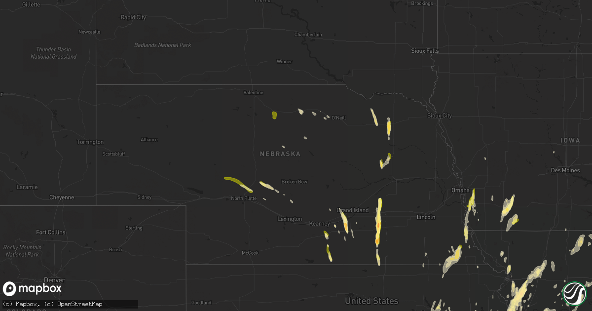
Hail Map in Nebraska on April 27, 2014
Get this storm
April 27 map
$229
one time, instant access
Download today. No call, no setup
Keep the $229
Bought the map and want the full workflow? Apply the entire $229 to a subscription within 7 days. None of it is wasted.
Every map, not just this one
This buys you this map. Subscription and you get every map we run, in the markets you choose from a few cities to whole states to nationwide. Plus real-time alerts the moment a storm fires.
Contact data
Name, contact info, occupancy, even credit band for addresses in the footprint. You go from where it hit to who to call.
Become the source they trust
Unlimited branding weather history reports on demand. You already have the documented answer ready for the property owner, and you are the one who showed up with it.
Property data and RoofTrace estimates
Pull up any address you have got, its value and the exact code rules for that jurisdiction, straight from One Click Code. Then RoofTrace estimates the squares, pitch, and roof value, priced the way you price.
Storm reports in Nebraska
Nebraska
| Date | Description |
|---|---|
| 04/27/20146:40 PM CDT | Also 50 to 60 mph winds. |
| 04/27/20146:40 PM CDT | Also 50 to 60 mph winds. |
| 04/27/20146:27 PM CDT | Also 60 mph wind. |
| 04/27/20146:16 PM CDT | A local report indicates 1.00 inch wind near 2 SSE BASSETT |
| 04/27/20145:58 PM CDT | A local report indicates 1.00 inch wind near 5 SSE ATKINSON |
| 04/27/20145:18 PM CDT | This is a corrected...approximate tornado location based on storm chaser video and radar data that shows tornado west of highway 39. Brief touchdown lasted approximatel |
| 04/27/20145:18 PM CDT | Brief touchdown lasted approximately 1 minute. Visual confirmation via live stream. |
| 04/27/20144:59 PM CDT | Heavy pea sized hail and 60 mph winds at mile marker 359 on i80. |
| 04/27/20144:59 PM CDT | Corrected location from original report to put at i-80 mile marker 359. Heavy pea sized hail and 60 mph winds. |
| 04/27/20144:45 PM CDT | Grape sized hail reported by spotter near sherman/valley county lines. |
| 04/27/20144:42 PM CDT | Brief touchdown near intersection of roads 18/h that lasted for 30-45 seconds. Will provide video for verification. Nickle hail ongoing at 448 pm. |
| 04/27/20144:23 PM CDT | A local report indicates 60 MPH wind near CAIRO |
| 04/27/20144:19 PM CDT | A local report indicates 1.00 inch wind near BRADSHAW |
| 04/27/20144:15 PM CDT | A local report indicates 62 MPH wind near 1 S WOOD RIVER |
| 04/27/20144:04 PM CDT | Corrected location to i-80 alda exit...not alda itself. Quarter to walnut sized hail near i-80 exit. Report/pic via twitter. |
| 04/27/20144:04 PM CDT | Quarter to walnut sized hail near i-80 exit. Report/pic via twitter. |
| 04/27/20144:03 PM CDT | Report and picture came in via twitter |
| 04/27/20143:54 PM CDT | Corrected time based on radar data to match location. Report and picture came in via twitter |
| 04/27/20143:52 PM CDT | A local report indicates 1.75 inch wind near 2 NE JUNIATA |
| 04/27/20143:47 PM CDT | Hail ongoing. |
| 04/27/20143:44 PM CDT | At adams central high school. |
| 04/27/20143:23 PM CDT | Twitter report |
| 04/27/20143:15 PM CDT | A local report indicates 1.75 inch wind near 3 N DAVENPORT |
| 04/27/20143:15 PM CDT | Time and location adjusted from original report to match radar data. Report via twitter. |
| 04/27/20142:29 PM CDT | Tornado on the ground from about 226 to 229. |
| 04/27/20142:25 PM CDT | Delayed reort of quarter size hail in byron. Reports via facebook and also trained spotter. |
| 04/27/20141:57 PM CDT | A local report indicates 1.00 inch wind near 5 NE FRANKLIN |
| 04/27/20141:10 PM CDT | A local report indicates 1.00 inch wind near 22 NNW NORTH PLATTE |
| 04/27/201412:55 PM CDT | A local report indicates 1.00 inch wind near 6 SE STAPLETON |
| 04/27/201412:08 PM CDT | A local report indicates 1.25 inch wind near 2 SW OCONTO |
| 04/26/20149:44 PM CDT | A local report indicates 1.00 inch wind near PLAINVIEW |
| 04/26/20148:55 PM CDT | Also 1.70 inches of rain. |
| 04/26/20148:30 PM CDT | Ground was white from hail. |
| 04/26/20148:25 PM CDT | Ground covered with pea size hail... A few up to the size of quarters. |
| 04/26/20147:40 PM CDT | A local report indicates 1.00 inch wind near 2 S LINDSAY |
All States Impacted by Hail Map on April 27, 2014
Cities Impacted by Hail Map on April 27, 2014
- Bedford, IA
- New Market, IA
- Stilwell, KS
- Bucyrus, KS
- Big Creek, MS
- Vardaman, MS
- Houlka, MS
- Calhoun City, MS
- Pittsboro, MS
- Tuskahoma, OK
- Topeka, KS
- Meriden, KS
- Lovelady, TX
- Trinity, TX
- Sarcoxie, MO
- Diamond, MO
- Reeds, MO
- Carthage, MO
- Avilla, MO
- Humboldt, NE
- Du Bois, NE
- Table Rock, NE
- Pawnee City, NE
- Burchard, NE
- Axtell, KS
- Baileyville, KS
- Bryan, TX
- Hominy, OK
- Cleveland, OK
- Fairfax, OK
- Pawhuska, OK
- Wynona, OK
- Pawnee, OK
- Maramec, OK
- Jennings, OK
- Yale, OK
- Mayflower, AR
- Roland, AR
- Bee Branch, AR
- Damascus, AR
- Trimble, MO
- Kansas City, MO
- Stewartsville, MO
- Gower, MO
- Plattsburg, MO
- Smithville, MO
- Camden Point, MO
- Edgerton, MO
- Platte City, MO
- Dearborn, MO
- Paola, KS
- Osawatomie, KS
- Wills Point, TX
- Alpena, AR
- Juniata, NE
- Doniphan, NE
- Wood River, NE
- Hastings, NE
- Giddings, TX
- Lincoln, TX
- Ledbetter, TX
- Villisca, IA
- Clarinda, IA
- Corning, IA
- Nodaway, IA
- Carbon, IA
- Westmoreland, KS
- Wamego, KS
- Manhattan, KS
- Saint George, KS
- Verona, MO
- Monett, MO
- Bivins, TX
- Rodessa, LA
- Benton, MS
- Queen City, TX
- Atlanta, TX
- Meridian, MS
- Enterprise, MS
- Tishomingo, OK
- Decatur, TX
- Sanger, TX
- Gainesville, TX
- Deer, AR
- Ozone, AR
- Jefferson, TX
- Tunica, MS
- Dundee, MS
- Faucett, MO
- Agency, MO
- De Witt, AR
- Saint Charles, AR
- Ethel, AR
- Holly Grove, AR
- Springfield, TN
- Senatobia, MS
- Sardis, MS
- Como, MS
- Purdy, MO
- Belvue, KS
- Paxico, KS
- Savannah, MO
- Amazonia, MO
- Chandler, OK
- Shawnee, KS
- Waldron, MO
- Kansas City, KS
- Leavenworth, KS
- De Soto, KS
- Bonner Springs, KS
- Lenexa, KS
- Groesbeck, TX
- Mart, TX
- Hearne, TX
- Chesterfield, IL
- Greenfield, IL
- Palmyra, IL
- Hettick, IL
- Talihina, OK
- Wilburton, OK
- Clayton, OK
- Daisy, OK
- Antlers, OK
- Mccurtain, OK
- Bokoshe, OK
- Pittsburg, OK
- Nashoba, OK
- Red Oak, OK
- Wister, OK
- Kinta, OK
- Forest, MS
- Henderson, NE
- Grafton, NE
- Sutton, NE
- Fulton, AR
- Emmet, AR
- Hope, AR
- Prescott, AR
- Carlisle, AR
- Cabool, MO
- Willow Springs, MO
- Mount Vernon, AR
- Enola, AR
- Nebraska City, NE
- Percival, IA
- Auburn, NE
- Peru, NE
- Morganfield, KY
- Trenton, KY
- Guthrie, KY
- Clarksville, TN
- Allensville, KY
- Alligator, MS
- Duncan, MS
- Arlington, TN
- Terrell, TX
- Foster, MO
- Freeburg, MO
- Belle, MO
- Sparkman, AR
- Carthage, AR
- Crocker, MO
- Brumley, MO
- Iberia, MO
- Richland, MO
- Eldridge, MO
- Lebanon, MO
- Montreal, MO
- Stoutland, MO
- Douglass, TX
- Nacogdoches, TX
- Mountain Home, AR
- Geneva, NE
- Elkton, KY
- Adams, TN
- Olmstead, KY
- Auxvasse, MO
- Warrensburg, MO
- Randolph, MS
- Wyandotte, OK
- Grove, OK
- Fairland, OK
- Afton, OK
- Virgil, KS
- Toronto, KS
- Bronaugh, MO
- Brady, NE
- Callaway, NE
- Gothenburg, NE
- Arnold, NE
- Temple, OK
- Hastings, OK
- Cameron, TX
- Gause, TX
- Winnsboro, TX
- Oran, MO
- Scott, AR
- North Little Rock, AR
- Uniontown, KS
- Redfield, KS
- Hepler, KS
- Utica, KY
- Owensboro, KY
- Calhoun, KY
- Blanco, OK
- Mineola, IA
- Silver City, IA
- Treynor, IA
- Pacific Junction, IA
- Glenwood, IA
- Bristow, OK
- Depew, OK
- Hughes Springs, TX
- Avinger, TX
- Linden, TX
- Lone Star, TX
- Douglassville, TX
- Bloomburg, TX
- Daingerfield, TX
- Jewett, TX
- Marquez, TX
- Marion, IL
- Ozark, IL
- Creal Springs, IL
- Goreville, IL
- Booneville, AR
- Hartsburg, MO
- New Bloomfield, MO
- Hugo, OK
- Spencerville, OK
- Rattan, OK
- Sherwood, AR
- Jacksonville, AR
- Corrigan, TX
- Maud, TX
- Greenbrier, AR
- Conway, AR
- Nowata, OK
- Whitesboro, TX
- Neosho Falls, KS
- Yates Center, KS
- Le Roy, KS
- Burton, TX
- McDade, TX
- Paige, TX
- Brenham, TX
- Carmine, TX
- Ida, LA
- Licking, MO
- Duke, MO
- Newburg, MO
- Edgar Springs, MO
- Honobia, OK
- Bethel, OK
- Bosworth, MO
- De Witt, MO
- Mayview, MO
- Holden, MO
- Centerview, MO
- Higginsville, MO
- Odessa, MO
- Gurdon, AR
- Conehatta, MS
- Cameron, MO
- Weatherby, MO
- Winston, MO
- Maysville, MO
- De Valls Bluff, AR
- Carthage, IL
- Plymouth, IL
- Alba, TX
- Seneca, MO
- Neosho, MO
- Shawneetown, IL
- New Haven, IL
- West Helena, AR
- Helena, AR
- Lexa, AR
- Elaine, AR
- Marianna, AR
- Stuttgart, AR
- Lyon, MS
- Clarksdale, MS
- Otterville, MO
- Marietta, TX
- Overland Park, KS
- Kenesaw, NE
- Waldron, AR
- Summersville, MO
- Eunice, MO
- Hartshorn, MO
- Yukon, MO
- Raymondville, MO
- Bates City, MO
- Orrick, MO
- Buckner, MO
- Wellington, MO
- Lone Jack, MO
- Henrietta, MO
- Levasy, MO
- Sibley, MO
- Oak Grove, MO
- Napoleon, MO
- Richmond, MO
- Camden, MO
- Grain Valley, MO
- Snow, OK
- Humphrey, AR
- Wabbaseka, AR
- Altheimer, AR
- Henderson, TX
- Howard, KS
- Witts Springs, AR
- Elk Creek, MO
- Austin, AR
- Beebe, AR
- Ward, AR
- Cabot, AR
- Gilmer, TX
- Hartshorne, OK
- Bradshaw, NE
- Polk, NE
- Leslie, AR
- Marshall, AR
- Vanzant, MO
- Alto, TX
- Edmond, OK
- Oklahoma City, OK
- Big Flat, AR
- Forsyth, MO
- Rockaway Beach, MO
- Taneyville, MO
- Branson, MO
- Shelbyville, TX
- Fort Scott, KS
- Fairfield, TX
- Streetman, TX
- Edgewood, TX
- Crockett, TX
- Boonville, MO
- Franklin, MO
- New Franklin, MO
- Red Rock, OK
- Ponca City, OK
- Olpe, KS
- Emporia, KS
- Allen, KS
- Americus, KS
- Henderson, AR
- Gamaliel, AR
- Elizabeth, AR
- Braymer, MO
- Carrollton, MO
- Norborne, MO
- Rosston, AR
- Yukon, OK
- Jefferson City, MO
- Madison, NE
- Emory, TX
- Kaufman, TX
- Fruitvale, TX
- Scurry, TX
- Grand Saline, TX
- Quitman, TX
- Mineola, TX
- Warsaw, MO
- Wheatland, MO
- Edwards, MO
- Quincy, MO
- Clinton, AR
- Shirley, AR
- Russellville, AR
- Norfolk, NE
- Wausa, NE
- Pierce, NE
- Mclean, NE
- Osmond, NE
- Emerson, AR
- Taylor, AR
- Springhill, LA
- Sheridan, AR
- Melrose, IA
- Yantis, TX
- Point, TX
- Garden City, MO
- Pleasant Hill, MO
- Kingsville, MO
- Strasburg, MO
- Edmondson, AR
- Proctor, AR
- Mount Pleasant, TX
- Omaha, TX
- Concordia, MO
- Fayette, MO
- Pilot Grove, MO
- Rocheport, MO
- Bunceton, MO
- Peculiar, MO
- Harrisonville, MO
- Raymore, MO
- Stapleton, NE
- Oakwood, TX
- Davenport, NE
- Shickley, NE
- Dardanelle, AR
- Pine Bluff, AR
- Grady, AR
- Thornton, AR
- Fordyce, AR
- Kingsland, AR
- Ivan, AR
- Chidester, AR
- Rison, AR
- Camden, AR
- Bearden, AR
- Caddo Gap, AR
- Royal, AR
- Mount Ida, AR
- Mountain Pine, AR
- Glenwood, AR
- Hot Springs Village, AR
- Hot Springs National Park, AR
- Paron, AR
- Jessieville, AR
- Bonnerdale, AR
- Norman, AR
- Stroud, OK
- Davenport, OK
- Meeker, OK
- Sparks, OK
- Mena, AR
- Mount Vernon, IL
- Liberty, MO
- Kearney, MO
- Ravenna, NE
- Sheldon, MO
- El Dorado Springs, MO
- Rockville, MO
- Schell City, MO
- Roe, AR
- McCune, KS
- Walnut, KS
- Girard, KS
- Kosciusko, MS
- Ethel, MS
- Butler, MO
- Walker, MO
- Appleton City, MO
- Henning, TN
- Memphis, TN
- Marion, AR
- Covington, TN
- Burlison, TN
- Atoka, TN
- Crawfordsville, AR
- Millington, TN
- Brighton, TN
- Mason, TN
- Cordova, TN
- Drummonds, TN
- Munford, TN
- Turrell, AR
- Dover, AR
- White Hall, AR
- Dennard, AR
- Houston, MO
- Pulaski, MS
- Prescott, KS
- Magazine, AR
- Havana, AR
- Blue Mountain, AR
- Woodward, IA
- Madrid, IA
- Thompson, MO
- Centralia, MO
- Elkhart, TX
- Grapeland, TX
- Tecumseh, MO
- Caulfield, MO
- Riverton, NE
- Franklin, NE
- Vilonia, AR
- Bruce, MS
- Derma, MS
- Pontotoc, MS
- Houston, MS
- Tuscumbia, MO
- Groveton, TX
- Wells, TX
- Kennard, TX
- Apple Springs, TX
- Moundville, MO
- Liberal, MO
- Louisburg, KS
- Grandview, MO
- Leawood, KS
- Belton, MO
- Del Valle, TX
- Buffalo, TX
- Palestine, TX
- Teague, TX
- Parsons, KS
- Saint Paul, KS
- Erie, KS
- Pattonsburg, MO
- Sharpsburg, IA
- Gravity, IA
- Marks, MS
- Tutwiler, MS
- Vance, MS
- Lambert, MS
- Ina, IL
- Whittington, IL
- Waltonville, IL
- Woodlawn, IL
- Benton, IL
- Bonnie, IL
- Doddridge, AR
- Plain Dealing, LA
- Bradley, AR
- Vivian, LA
- Pangburn, AR
- Olsburg, KS
- Smithville, OK
- Telephone, TX
- Hodgen, OK
- Boswell, OK
- Bennington, OK
- Soper, OK
- Coahoma, MS
- Mansfield, MO
- Crossville, TN
- Mulberry, AR
- Mountainburg, AR
- Altamont, MO
- Jameson, MO
- Osborn, MO
- Gallatin, MO
- Lonoke, AR
- Okemah, OK
- Jacksonville, TX
- Heavener, OK
- Odell, NE
- Syracuse, MO
- Blackwater, MO
- Delaware, AR
- Pelsor, AR
- London, AR
- Saint Elizabeth, MO
- Saint Thomas, MO
- Meta, MO
- Huntington, TX
- Ravenna, TX
- Ivanhoe, TX
- Pollock, MO
- Lucerne, MO
- Newtown, MO
- Rockwall, TX
- Moran, KS
- Bronson, KS
- Pittsburg, TX
- Scroggins, TX
- Leesburg, TX
- Naples, TX
- Grand Prairie, TX
- Cushing, OK
- Drumright, OK
- Sarah, MS
- Newkirk, OK
- Windyville, MO
- Buffalo, MO
- Vinita, OK
- Holts Summit, MO
- Blue Mound, KS
- Mound City, KS
- La Russell, MO
- Stotts City, MO
- Ripley, TN
- Yazoo City, MS
- Olive Branch, MS
- Collierville, TN
- Gepp, AR
- Shidler, OK
- Calico Rock, AR
- Pleasanton, KS
- Eros, LA
- Calhoun, LA
- Olathe, KS
- Summerfield, KS
- Onia, AR
- Nunnelly, TN
- Centerville, TN
- Murray, KY
- Hazel, KY
- York, NE
- Ong, NE
- Sulphur, OK
- Milo, MO
- Casscoe, AR
- Guthrie, OK
- Crescent, OK
- Cashion, OK
- Willard, MO
- Mill Creek, OK
- Mannsville, OK
- Brinktown, MO
- Waynesville, MO
- Devils Elbow, MO
- Dixon, MO
- Vienna, MO
- Fort Leonard Wood, MO
- Saint Robert, MO
- Lomax, IL
- Leland, MS
- Atoka, OK
- England, AR
- McCool, MS
- Kevil, KY
- Dora, MO
- Ola, AR
- Searcy, AR
- Heber Springs, AR
- Romance, AR
- Rose Bud, AR
- Columbus, KS
- Paradise, TX
- Westphalia, MO
- Minden, NE
- Thornton, TX
- Riesel, TX
- Donie, TX
- Boles, AR
- Royse City, TX
- Lamar, MO
- Madison, MO
- Star City, AR
- Yorktown, AR
- Bartlesville, OK
- Mounds, OK
- Okmulgee, OK
- Glenpool, OK
- Kiefer, OK
- Sapulpa, OK
- Beggs, OK
- Argyle, MO
- Garland City, AR
- Lewisville, AR
- Texarkana, TX
- Texarkana, AR
- Fouke, AR
- Rockfield, KY
- Stuart, NE
- Saint Joseph, MO
- Inverness, MS
- Harriet, AR
- Morton, MS
- Shawnee, OK
- Winner, SD
- Deshler, NE
- Byron, NE
- Republic, KS
- Petrolia, TX
- Dierks, AR
- Umpire, AR
- Buchanan, TN
- Oconto, NE
- Bastrop, TX
- Gravois Mills, MO
- Climax Springs, MO
- Stover, MO
- Kirbyville, MO
- Garrison, MO
- Hollister, MO
- Dickson, TN
- McEwen, TN
- Mendon, MO
- Brookfield, MO
- Rothville, MO
- Mount Vernon, TX
- Eminence, MO
- Spring Hill, KS
- Gardner, KS
- Dawn, MO
- Tchula, MS
- Belzoni, MS
- Mindenmines, MO
- Oronogo, MO
- Asbury, MO
- Ozark, AR
- Hagarville, AR
- Oark, AR
- Pettigrew, AR
- Mount Judea, AR
- Clay, KY
- Henderson, KY
- Corydon, KY
- Sebree, KY
- Slaughters, KY
- Robards, KY
- Dixon, KY
- Waverly, KY
- Solo, MO
- Bakersfield, MO
- West Plains, MO
- Mountain View, MO
- Pottersville, MO
- Pomona, MO
- Mount Vernon, IN
- New Harmony, IN
- Adona, AR
- Casa, AR
- Perryville, AR
- Morrilton, AR
- Granby, MO
- Pelican, LA
- Converse, LA
- Pittsburg, KS
- Weir, KS
- Galena, KS
- Carl Junction, MO
- Scotland, AR
- Mountain View, AR
- Fox, AR
- Jerusalem, AR
- Claremore, OK
- Hernando, MS
- Sledge, MS
- Coldwater, MS
- Moyers, OK
- Finley, OK
- Plumerville, AR
- Springfield, AR
- Bucyrus, MO
- Grapevine, AR
- Arkadelphia, AR
- Lohman, MO
- Russellville, MO
- Parks, AR
- Harvey, AR
- Humboldt, KS
- Savonburg, KS
- Elsmore, KS
- Tebbetts, MO
- Benedict, NE
- Stromsburg, NE
- Arlington, TX
- Plainview, NE
- Creighton, NE
- Winnetoon, NE
- Chelsea, OK
- Big Cabin, OK
- Holliday, MO
- Nashville, TN
- Ashland City, TN
- Rich Hill, MO
- Durant, MS
- Bassett, NE
- Sedalia, KY
- Utica, MS
- Tonganoxie, KS
- Marvell, AR
- Clarendon, AR
- Sturgis, KY
- Hazen, AR
- Ulm, AR
- Lindsay, NE
- Marceline, MO
- Sumner, MO
- Center, TX
- Aubrey, AR
- Kaw City, OK
- Clark, MO
- Higbee, MO
- Moberly, MO
- Cedar Creek, TX
- West Monroe, LA
- Golden, IL
- Camp Point, IL
- Bowen, IL
- New Blaine, AR
- Paris, AR
- Scranton, AR
- Crawford, TX
- Oglesby, TX
- McGregor, TX
- Hubbard, TX
- Mount Calm, TX
- Wortham, TX
- Coolidge, TX
- Luther, OK
- Arcadia, OK
- Garnett, KS
- Crenshaw, MS
- Holly Springs, MS
- Batesville, MS
- Lane, OK
- White City, KS
- Natchitoches, LA
- Ozark, MO
- Rogersville, MO
- Bluejacket, OK
- Little Elm, TX
- Tennessee Colony, TX
- Mexia, TX
- Rusk, TX
- Montalba, TX
- Axtell, TX
- Long Branch, TX
- Carthage, TX
- Mount Enterprise, TX
- Coushatta, LA
- Vaughan, MS
- Snow Lake, AR
- Como, TX
- Canton, TX
- Blue Springs, NE
- Beatrice, NE
- Franklin, TX
- Moody, MO
- Greenville, MS
- Broaddus, TX
- Pineland, TX
- Bronson, TX
- Zavalla, TX
- Brewster, NE
- Forney, TX
- Nettleton, MS
- Okolona, MS
- Shannon, MS
- Fort Towson, OK
- Cedar Vale, KS
- Milano, TX
- Crofton, KY
- Green Castle, MO
- Farmersville, TX
- Gould, AR
- Gillett, AR
- Adrian, MO
- Archie, MO
- Indianola, MS
- Sunflower, MS
- Glenvil, NE
- Centertown, MO
- Waurika, OK
- Ringling, OK
- Lone Oak, TX
- Palmer, TX
- Ennis, TX
- Rosser, TX
- Jones, OK
- Norfork, AR
- Kingston, OK
- Timbo, AR
- Ava, MO
- Kingston Springs, TN
- White Bluff, TN
- Joelton, TN
- Ardmore, OK
- Spring Valley, MN
- San Augustine, TX
- Benton, KY
- Turney, MO
- Letona, AR
- Goldonna, LA
- Ridgely, TN
- Tiptonville, TN
- Portageville, MO
- Fulton, MO
- Bonnots Mill, MO
- Henley, MO
- Eugene, MO
- Ashland, MO
- Olean, MO
- Eldon, MO
- Mayfield, KY
- Watson, AR
- Heth, AR
- Hughes, AR
- Forrest City, AR
- Brickeys, AR
- Cookville, TX
- Clarkridge, AR
- Vermillion, KS
- Diana, TX
- Rockdale, TX
- Davilla, TX
- Carthage, MS
- Newman Grove, NE
- Humphrey, NE
- Washington, AR
- Ozan, AR
- Cameron, OK
- Poteau, OK
- Jamesport, MO
- Triplett, MO
- Malta Bend, MO
- Miller, MO
- Lenox, IA
- Lawrence, KS
- Campti, LA
- Udall, MO
- Gainesville, MO
- Pollok, TX
- Dumas, AR
- Melber, KY
- Cunningham, KY
- Osage, OK
- Brighton, MO
- Morrisville, MO
- West Fork, AR
- Prairie Grove, AR
- Eddyville, NE
- Coalgate, OK
- Calvin, OK
- Iowa City, IA
- Lawrence, MS
- Newton, MS
- Lancaster, TX
- Wilmer, TX
- Red Oak, TX
- Little Rock, AR
- Bigelow, AR
- McRae, AR
- El Paso, AR
- Little Rock Air Force Base, AR
- Junction City, KS
- Byhalia, MS
- Clifton, TN
- Atkins, AR
- Hattieville, AR
- Pierce City, MO
- Graham, MO
- Viola, AR
- Bexar, AR
- Hector, AR
- Alma, AR
- Shell Knob, MO
- Drexel, MO
- Wickliffe, KY
- La Center, KY
- Elk City, KS
- Kalona, IA
- Atkinson, NE
- Tulsa, OK
- Jenks, OK
- Rutherford, TN
- Kenton, TN
- Dyer, TN
- Sharon, TN
- Greenfield, TN
- Fall River, KS
- Fredonia, KS
- Clarksville, AR
- Linden, AL
- York, AL
- Spickard, MO
- Valley View, TX
- Pilot Point, TX
- Collinsville, TX
- Tioga, TX
- Cheney, KS
- Montgomery City, MO
- Portland, MO
- Alda, NE
- Drew, MS
- South Greenfield, MO
- De Kalb, MS
- Daleville, MS
- Spencer, OK
- Choctaw, OK
- Opolis, KS
- Scammon, KS
- Washington, TX
- Newburgh, IN
- Reed, KY
- Piqua, KS
- Westphalia, KS
- Decatur, MS
- Jonesboro, LA
- Saline, LA
- Bienville, LA
- Gassville, AR
- Big Sandy, TX
- Alma, KS
- Alta Vista, KS
- Louann, AR
- Magnolia, AR
- Stephens, AR
- Blackburn, MO
- Columbia, MO
- Parchman, MS
- Gunnison, MS
- Shelby, MS
- Mound Bayou, MS
- Robinsonville, MS
- Tichnor, AR
- Laneville, TX
- Madison, KS
- Elk Creek, NE
- Chester, TX
- Hermanville, MS
- Broken Bow, OK
- Woodbine, KS
- Chapman, KS
- Barnett, MO
- Versailles, MO
- Marthaville, LA
- Unionville, MO
- Princeton, MO
- Trenton, MO
- Powersville, MO
- Galt, MO
- Harris, MO
- Milan, MO
- Tenaha, TX
- Joaquin, TX
- Gary, TX
- Timpson, TX
- Cushing, TX
- Poplar Grove, AR
- Cole Camp, MO
- Green City, MO
- Florence, MO
- Roseland, NE
- Linn, MO
- Loose Creek, MO
- Burbank, OK
- Cape Fair, MO
- Galena, MO
- Burwell, NE
- Era, TX
- Boyle, MS
- Shaw, MS
- Cleveland, MS
- Malvern, IA
- Tabor, IA
- Council Bluffs, IA
- Thurman, IA
- Allen, TX
- Mckinney, TX
- Plano, TX
- Waxahachie, TX
- Buckner, IL
- Dix, IL
- Belleville, AR
- Knoxville, AR
- Danville, AR
- Lamar, AR
- Chamois, MO
- Marlow, OK
- Duncan, OK
- Comanche, OK
- Amsterdam, MO
- Pocola, OK
- Chester, AR
- Winslow, AR
- Only, TN
- Centerville, TX
- Richards, MO
- Hume, MO
- Hampton, AR
- Byers, TX
- Mansfield, LA
- Kincaid, KS
- Welda, KS
- Keatchie, LA
- Grand Cane, LA
- Herington, KS
- Smithville, TX
- Princeton, TX
- Lexington, MS
- Harwood, MO
- Philpot, KY
- Amoret, MO
- Mapleton, KS
- Fulton, KS
- Stark, KS
- La Cygne, KS
- Hartford, KS
- Green Forest, AR
- Compton, AR
- Charlotte, IA
- Basehor, KS
- Dexter, KY
- Almo, KY
- Perry, OK
- Morrison, OK
- Bardwell, KY
- Clinton, KY
- Fancy Farm, KY
- Arlington, KY
- Wylie, TX
- Dallas, TX
- Richardson, TX
- Garland, TX
- Sachse, TX
- Osceola, MO
- Montrose, MO
- Clinton, MO
- Linden, TN
- Cairo, NE
- Salem, MO
- Quinlan, TX
- Caddo Mills, TX
- Randolph, IA
- Hardin, KY
- Massena, IA
- Farmington, KY
- Jerico Springs, MO
- La Prairie, IL
- Tennessee, IL
- Augusta, IL
- Sidney, IA
- Hatfield, AR
- Sadler, TX
- Pottsboro, TX
- Peace Valley, MO
- Wooldridge, MO
- Steinauer, NE
- Center Ridge, AR
- Upland, NE
- Edgerton, KS
- Wellsville, KS
- Spragueville, IA
- Midway, TX
- Admire, KS
- Roby, MO
- Quinton, OK
- Reeds Spring, MO
- Kimberling City, MO
- Lampe, MO
- Perry, AR
- Cedarville, AR
- Piedmont, MO
- Patterson, MO
- Needham, AL
- Cottonwood Falls, KS
- Lockwood, MO
- Long Lane, MO
- Phillipsburg, MO
- Ulman, MO
- Stilwell, OK
- Sallisaw, OK
- Fillmore, MO
- Bolckow, MO
- Nevada, MO
- Mulberry, KS
- Arcadia, KS
- Puryear, TN
- La Harpe, KS
- Colony, KS
- Valley Falls, KS
- Denison, KS
- Dolph, AR
- Pineville, AR
- Woodland, MS
- Fayetteville, AR
- Dresden, TN
- Collinsville, OK
- Owasso, OK
- Oologah, OK
- Catoosa, OK
- Red Oak, IA
- Griswold, IA
- Elliott, IA
- Seagoville, TX
- Mount Vernon, MO
- Fairfield, IA
- Cottontown, TN
- White House, TN
- Hendersonville, TN
- Orlinda, TN
- Cross Plains, TN
- Portland, TN
- Greenbrier, TN
- Goodlettsville, TN
- Midlothian, TX
- North Platte, NE
- Weaubleau, MO
- Maple City, KS
- Almyra, AR
- Caddo, OK
- Caney, OK
- Rumsey, KY
- Island, KY
- Sacramento, KY
- Sweet Water, AL
- Shady Point, OK
- Dwight, KS
- Jasper, MO
- Golden City, MO
- Nemaha, NE
- Chanute, KS
- Belmont, LA
- Zwolle, LA
- Pleasant Hill, LA
- Welch, OK
- Hawkins, TX
- Walnut Shade, MO
- Knob Noster, MO
- Canton, MS
- Farley, MO
- Utica, MO
- New Haven, MO
- Lexington, MO
- Logansport, LA
- Louisville, IL
- Arkansas City, KS
- Pickton, TX
- Tonkawa, OK
- Modesto, IL
- Baxter Springs, KS
- Quapaw, OK
- Miami, OK
- Commerce, OK
- North Miami, OK
- Picher, OK
- Dodge Center, MN
- Mantee, MS
- Plainview, AR
- Wentworth, MO
- Jay, OK
- Greenfield, MO
- Everton, MO
- Clearmont, MO
- Meridian, OK
- Ashland, LA
- Rudy, AR
- Van Buren, AR
- Weston, MO
- Lake, MS
- Lone Grove, OK
- Overbrook, OK
- Trumbull, NE
- Oldfield, MO
- Bradleyville, MO
- Wellston, OK
- Mcloud, OK
- Sedalia, MO
- Parkin, AR
- Chillicothe, MO
- Chireno, TX
- Lufkin, TX
- Pennington, TX
- Hardin, MO
- Goodwater, AL
- Martin, TN
- Enterprise, KS
- Sherrill, AR
- Stringtown, OK
- Lathrop, MO
- Holt, MO
- Earling, IA
- Hiawatha, KS
- Merigold, MS
- Cleveland, AR
- Lexington, TX
- Adair, IA
- Casey, IA
- Linwood, KS
- Lansing, KS
- Eudora, KS
- Riverside, MO
- New Century, KS
- Harrah, OK
- Macks Creek, MO
- Camdenton, MO
- Bixby, OK
- Bremen, KS
- Frankfort, KY
- Sweet Springs, MO
- Auburn, KY
- Bowling Green, KY
- Braman, OK
- South Haven, KS
- Mountain Grove, MO
- Marland, OK
- Mulhall, OK
- Coyle, OK
- Cummings, KS
- Lincoln, MO
- Madill, OK
- Ward, AL
- Sallis, MS
- Goodman, MS
- Pickens, MS
- Mercer, MO
- Lineville, IA
- Moscow, TX
- Livingston, TX
- McLouth, KS
- Oskaloosa, KS
- Griffithville, AR
- Higginson, AR
- Crystal Springs, MS
- Bentonia, MS
- Vicksburg, MS
- Louise, MS
- Anguilla, MS
- Mayersville, MS
- Hollandale, MS
- Rolling Fork, MS
- Drasco, AR
- Tumbling Shoals, AR
- Concord, AR
- Paragould, AR
- Rector, AR
- Marmaduke, AR
- Kennett, MO
- Greenway, AR
- McClelland, IA
- Johnstown, NE
- Tryon, NE
- Bradford, AR
- Tuckerman, AR
- Maumelle, AR
- Oil Trough, AR
- Judsonia, AR
- Pleasant Plains, AR
- Newark, AR
- Newport, AR
- Nash, TX
- Ridgway, IL
- Omaha, IL
- Marthasville, MO


