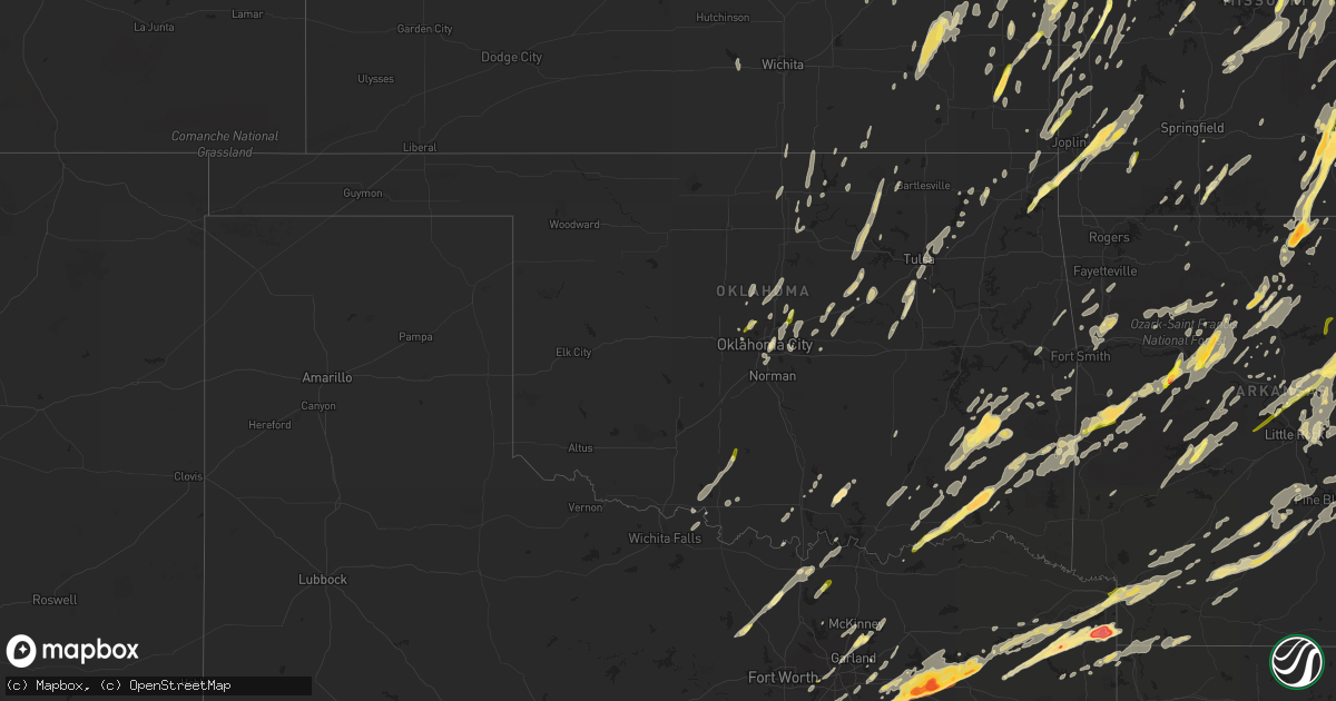
Hail Map in Oklahoma on April 27, 2014
Get this storm
April 27 map
$229
one time, instant access
Download today. No call, no setup
Keep the $229
Bought the map and want the full workflow? Apply the entire $229 to a subscription within 7 days. None of it is wasted.
Every map, not just this one
This buys you this map. Subscription and you get every map we run, in the markets you choose from a few cities to whole states to nationwide. Plus real-time alerts the moment a storm fires.
Contact data
Name, contact info, occupancy, even credit band for addresses in the footprint. You go from where it hit to who to call.
Become the source they trust
Unlimited branding weather history reports on demand. You already have the documented answer ready for the property owner, and you are the one who showed up with it.
Property data and RoofTrace estimates
Pull up any address you have got, its value and the exact code rules for that jurisdiction, straight from One Click Code. Then RoofTrace estimates the squares, pitch, and roof value, priced the way you price.
Storm reports in Oklahoma
Oklahoma
| Date | Description |
|---|---|
| 04/27/20145:33 PM CDT | 1.9 miles nne of octavia...rated ef1 |
| 04/27/20145:32 PM CDT | Many trees blown down. Power poles down. |
| 04/27/20145:32 PM CDT | Fire station destroyed. North end of town sustained heavy damage. |
| 04/27/20145:24 PM CDT | Damaged sideing on homes. Broke windows. At least one car had back window broken out by hail. |
| 04/27/20145:20 PM CDT | Large trees uprooted and other tree damage around patricia island and just south of sail boat bridge...harbor road. |
| 04/27/20144:44 PM CDT | A local report indicates 1.75 inch wind near 3 S DAMON |
| 04/27/20144:18 PM CDT | Covered the ground...mostly nickel to quarter size. |
| 04/27/20143:53 PM CDT | A local report indicates 1.00 inch wind near SOPER |
| 04/27/20143:26 PM CDT | A local report indicates 1.00 inch wind near 8 S BOSWELL |
| 04/27/201411:10 AM CDT | Metal roof of barn taken off and damaged powerlines. |
| 04/27/201410:45 AM CDT | A local report indicates 59 MPH wind near 1 WNW BIXBY |
| 04/27/20148:09 AM CDT | A local report indicates 1.00 inch wind near 5 NW VELMA |
| 04/27/20148:03 AM CDT | 59th and sunnylane |
| 04/27/20148:00 AM CDT | A local report indicates 1.75 inch wind near RAVIA |
| 04/27/20147:19 AM CDT | 164th and macarthur |
| 04/27/20147:18 AM CDT | Seward and coaltrane. Home damaged. Time estimated by radar. |
| 04/27/20147:15 AM CDT | A local report indicates 1.00 inch wind near 4 S LONE GROVE |
| 04/26/201410:50 PM CDT | Large tree limbs broken and down. Small hail...1/2 inch and less. |
| 04/26/201410:18 PM CDT | Report of 1.00 in hail from grocery store in battiest. |
| 04/26/20149:56 PM CDT | Two trees blown down on two different cars. Numerous large broken limbs. |
| 04/26/20149:39 PM CDT | 50-60 mph winds. |
| 04/26/20149:32 PM CDT | A local report indicates 1.00 inch wind near TALIHINA |
| 04/26/20149:28 PM CDT | Mostly penny to quarter size. |
All States Impacted by Hail Map on April 27, 2014
Cities Impacted by Hail Map on April 27, 2014
- Bedford, IA
- New Market, IA
- Stilwell, KS
- Bucyrus, KS
- Big Creek, MS
- Vardaman, MS
- Houlka, MS
- Calhoun City, MS
- Pittsboro, MS
- Tuskahoma, OK
- Topeka, KS
- Meriden, KS
- Lovelady, TX
- Trinity, TX
- Sarcoxie, MO
- Diamond, MO
- Reeds, MO
- Carthage, MO
- Avilla, MO
- Humboldt, NE
- Du Bois, NE
- Table Rock, NE
- Pawnee City, NE
- Burchard, NE
- Axtell, KS
- Baileyville, KS
- Bryan, TX
- Hominy, OK
- Cleveland, OK
- Fairfax, OK
- Pawhuska, OK
- Wynona, OK
- Pawnee, OK
- Maramec, OK
- Jennings, OK
- Yale, OK
- Mayflower, AR
- Roland, AR
- Bee Branch, AR
- Damascus, AR
- Trimble, MO
- Kansas City, MO
- Stewartsville, MO
- Gower, MO
- Plattsburg, MO
- Smithville, MO
- Camden Point, MO
- Edgerton, MO
- Platte City, MO
- Dearborn, MO
- Paola, KS
- Osawatomie, KS
- Wills Point, TX
- Alpena, AR
- Juniata, NE
- Doniphan, NE
- Wood River, NE
- Hastings, NE
- Giddings, TX
- Lincoln, TX
- Ledbetter, TX
- Villisca, IA
- Clarinda, IA
- Corning, IA
- Nodaway, IA
- Carbon, IA
- Westmoreland, KS
- Wamego, KS
- Manhattan, KS
- Saint George, KS
- Verona, MO
- Monett, MO
- Bivins, TX
- Rodessa, LA
- Benton, MS
- Queen City, TX
- Atlanta, TX
- Meridian, MS
- Enterprise, MS
- Tishomingo, OK
- Decatur, TX
- Sanger, TX
- Gainesville, TX
- Deer, AR
- Ozone, AR
- Jefferson, TX
- Tunica, MS
- Dundee, MS
- Faucett, MO
- Agency, MO
- De Witt, AR
- Saint Charles, AR
- Ethel, AR
- Holly Grove, AR
- Springfield, TN
- Senatobia, MS
- Sardis, MS
- Como, MS
- Purdy, MO
- Belvue, KS
- Paxico, KS
- Savannah, MO
- Amazonia, MO
- Chandler, OK
- Shawnee, KS
- Waldron, MO
- Kansas City, KS
- Leavenworth, KS
- De Soto, KS
- Bonner Springs, KS
- Lenexa, KS
- Groesbeck, TX
- Mart, TX
- Hearne, TX
- Chesterfield, IL
- Greenfield, IL
- Palmyra, IL
- Hettick, IL
- Talihina, OK
- Wilburton, OK
- Clayton, OK
- Daisy, OK
- Antlers, OK
- Mccurtain, OK
- Bokoshe, OK
- Pittsburg, OK
- Nashoba, OK
- Red Oak, OK
- Wister, OK
- Kinta, OK
- Forest, MS
- Henderson, NE
- Grafton, NE
- Sutton, NE
- Fulton, AR
- Emmet, AR
- Hope, AR
- Prescott, AR
- Carlisle, AR
- Cabool, MO
- Willow Springs, MO
- Mount Vernon, AR
- Enola, AR
- Nebraska City, NE
- Percival, IA
- Auburn, NE
- Peru, NE
- Morganfield, KY
- Trenton, KY
- Guthrie, KY
- Clarksville, TN
- Allensville, KY
- Alligator, MS
- Duncan, MS
- Arlington, TN
- Terrell, TX
- Foster, MO
- Freeburg, MO
- Belle, MO
- Sparkman, AR
- Carthage, AR
- Crocker, MO
- Brumley, MO
- Iberia, MO
- Richland, MO
- Eldridge, MO
- Lebanon, MO
- Montreal, MO
- Stoutland, MO
- Douglass, TX
- Nacogdoches, TX
- Mountain Home, AR
- Geneva, NE
- Elkton, KY
- Adams, TN
- Olmstead, KY
- Auxvasse, MO
- Warrensburg, MO
- Randolph, MS
- Wyandotte, OK
- Grove, OK
- Fairland, OK
- Afton, OK
- Virgil, KS
- Toronto, KS
- Bronaugh, MO
- Brady, NE
- Callaway, NE
- Gothenburg, NE
- Arnold, NE
- Temple, OK
- Hastings, OK
- Cameron, TX
- Gause, TX
- Winnsboro, TX
- Oran, MO
- Scott, AR
- North Little Rock, AR
- Uniontown, KS
- Redfield, KS
- Hepler, KS
- Utica, KY
- Owensboro, KY
- Calhoun, KY
- Blanco, OK
- Mineola, IA
- Silver City, IA
- Treynor, IA
- Pacific Junction, IA
- Glenwood, IA
- Bristow, OK
- Depew, OK
- Hughes Springs, TX
- Avinger, TX
- Linden, TX
- Lone Star, TX
- Douglassville, TX
- Bloomburg, TX
- Daingerfield, TX
- Jewett, TX
- Marquez, TX
- Marion, IL
- Ozark, IL
- Creal Springs, IL
- Goreville, IL
- Booneville, AR
- Hartsburg, MO
- New Bloomfield, MO
- Hugo, OK
- Spencerville, OK
- Rattan, OK
- Sherwood, AR
- Jacksonville, AR
- Corrigan, TX
- Maud, TX
- Greenbrier, AR
- Conway, AR
- Nowata, OK
- Whitesboro, TX
- Neosho Falls, KS
- Yates Center, KS
- Le Roy, KS
- Burton, TX
- McDade, TX
- Paige, TX
- Brenham, TX
- Carmine, TX
- Ida, LA
- Licking, MO
- Duke, MO
- Newburg, MO
- Edgar Springs, MO
- Honobia, OK
- Bethel, OK
- Bosworth, MO
- De Witt, MO
- Mayview, MO
- Holden, MO
- Centerview, MO
- Higginsville, MO
- Odessa, MO
- Gurdon, AR
- Conehatta, MS
- Cameron, MO
- Weatherby, MO
- Winston, MO
- Maysville, MO
- De Valls Bluff, AR
- Carthage, IL
- Plymouth, IL
- Alba, TX
- Seneca, MO
- Neosho, MO
- Shawneetown, IL
- New Haven, IL
- West Helena, AR
- Helena, AR
- Lexa, AR
- Elaine, AR
- Marianna, AR
- Stuttgart, AR
- Lyon, MS
- Clarksdale, MS
- Otterville, MO
- Marietta, TX
- Overland Park, KS
- Kenesaw, NE
- Waldron, AR
- Summersville, MO
- Eunice, MO
- Hartshorn, MO
- Yukon, MO
- Raymondville, MO
- Bates City, MO
- Orrick, MO
- Buckner, MO
- Wellington, MO
- Lone Jack, MO
- Henrietta, MO
- Levasy, MO
- Sibley, MO
- Oak Grove, MO
- Napoleon, MO
- Richmond, MO
- Camden, MO
- Grain Valley, MO
- Snow, OK
- Humphrey, AR
- Wabbaseka, AR
- Altheimer, AR
- Henderson, TX
- Howard, KS
- Witts Springs, AR
- Elk Creek, MO
- Austin, AR
- Beebe, AR
- Ward, AR
- Cabot, AR
- Gilmer, TX
- Hartshorne, OK
- Bradshaw, NE
- Polk, NE
- Leslie, AR
- Marshall, AR
- Vanzant, MO
- Alto, TX
- Edmond, OK
- Oklahoma City, OK
- Big Flat, AR
- Forsyth, MO
- Rockaway Beach, MO
- Taneyville, MO
- Branson, MO
- Shelbyville, TX
- Fort Scott, KS
- Fairfield, TX
- Streetman, TX
- Edgewood, TX
- Crockett, TX
- Boonville, MO
- Franklin, MO
- New Franklin, MO
- Red Rock, OK
- Ponca City, OK
- Olpe, KS
- Emporia, KS
- Allen, KS
- Americus, KS
- Henderson, AR
- Gamaliel, AR
- Elizabeth, AR
- Braymer, MO
- Carrollton, MO
- Norborne, MO
- Rosston, AR
- Yukon, OK
- Jefferson City, MO
- Madison, NE
- Emory, TX
- Kaufman, TX
- Fruitvale, TX
- Scurry, TX
- Grand Saline, TX
- Quitman, TX
- Mineola, TX
- Warsaw, MO
- Wheatland, MO
- Edwards, MO
- Quincy, MO
- Clinton, AR
- Shirley, AR
- Russellville, AR
- Norfolk, NE
- Wausa, NE
- Pierce, NE
- Mclean, NE
- Osmond, NE
- Emerson, AR
- Taylor, AR
- Springhill, LA
- Sheridan, AR
- Melrose, IA
- Yantis, TX
- Point, TX
- Garden City, MO
- Pleasant Hill, MO
- Kingsville, MO
- Strasburg, MO
- Edmondson, AR
- Proctor, AR
- Mount Pleasant, TX
- Omaha, TX
- Concordia, MO
- Fayette, MO
- Pilot Grove, MO
- Rocheport, MO
- Bunceton, MO
- Peculiar, MO
- Harrisonville, MO
- Raymore, MO
- Stapleton, NE
- Oakwood, TX
- Davenport, NE
- Shickley, NE
- Dardanelle, AR
- Pine Bluff, AR
- Grady, AR
- Thornton, AR
- Fordyce, AR
- Kingsland, AR
- Ivan, AR
- Chidester, AR
- Rison, AR
- Camden, AR
- Bearden, AR
- Caddo Gap, AR
- Royal, AR
- Mount Ida, AR
- Mountain Pine, AR
- Glenwood, AR
- Hot Springs Village, AR
- Hot Springs National Park, AR
- Paron, AR
- Jessieville, AR
- Bonnerdale, AR
- Norman, AR
- Stroud, OK
- Davenport, OK
- Meeker, OK
- Sparks, OK
- Mena, AR
- Mount Vernon, IL
- Liberty, MO
- Kearney, MO
- Ravenna, NE
- Sheldon, MO
- El Dorado Springs, MO
- Rockville, MO
- Schell City, MO
- Roe, AR
- McCune, KS
- Walnut, KS
- Girard, KS
- Kosciusko, MS
- Ethel, MS
- Butler, MO
- Walker, MO
- Appleton City, MO
- Henning, TN
- Memphis, TN
- Marion, AR
- Covington, TN
- Burlison, TN
- Atoka, TN
- Crawfordsville, AR
- Millington, TN
- Brighton, TN
- Mason, TN
- Cordova, TN
- Drummonds, TN
- Munford, TN
- Turrell, AR
- Dover, AR
- White Hall, AR
- Dennard, AR
- Houston, MO
- Pulaski, MS
- Prescott, KS
- Magazine, AR
- Havana, AR
- Blue Mountain, AR
- Woodward, IA
- Madrid, IA
- Thompson, MO
- Centralia, MO
- Elkhart, TX
- Grapeland, TX
- Tecumseh, MO
- Caulfield, MO
- Riverton, NE
- Franklin, NE
- Vilonia, AR
- Bruce, MS
- Derma, MS
- Pontotoc, MS
- Houston, MS
- Tuscumbia, MO
- Groveton, TX
- Wells, TX
- Kennard, TX
- Apple Springs, TX
- Moundville, MO
- Liberal, MO
- Louisburg, KS
- Grandview, MO
- Leawood, KS
- Belton, MO
- Del Valle, TX
- Buffalo, TX
- Palestine, TX
- Teague, TX
- Parsons, KS
- Saint Paul, KS
- Erie, KS
- Pattonsburg, MO
- Sharpsburg, IA
- Gravity, IA
- Marks, MS
- Tutwiler, MS
- Vance, MS
- Lambert, MS
- Ina, IL
- Whittington, IL
- Waltonville, IL
- Woodlawn, IL
- Benton, IL
- Bonnie, IL
- Doddridge, AR
- Plain Dealing, LA
- Bradley, AR
- Vivian, LA
- Pangburn, AR
- Olsburg, KS
- Smithville, OK
- Telephone, TX
- Hodgen, OK
- Boswell, OK
- Bennington, OK
- Soper, OK
- Coahoma, MS
- Mansfield, MO
- Crossville, TN
- Mulberry, AR
- Mountainburg, AR
- Altamont, MO
- Jameson, MO
- Osborn, MO
- Gallatin, MO
- Lonoke, AR
- Okemah, OK
- Jacksonville, TX
- Heavener, OK
- Odell, NE
- Syracuse, MO
- Blackwater, MO
- Delaware, AR
- Pelsor, AR
- London, AR
- Saint Elizabeth, MO
- Saint Thomas, MO
- Meta, MO
- Huntington, TX
- Ravenna, TX
- Ivanhoe, TX
- Pollock, MO
- Lucerne, MO
- Newtown, MO
- Rockwall, TX
- Moran, KS
- Bronson, KS
- Pittsburg, TX
- Scroggins, TX
- Leesburg, TX
- Naples, TX
- Grand Prairie, TX
- Cushing, OK
- Drumright, OK
- Sarah, MS
- Newkirk, OK
- Windyville, MO
- Buffalo, MO
- Vinita, OK
- Holts Summit, MO
- Blue Mound, KS
- Mound City, KS
- La Russell, MO
- Stotts City, MO
- Ripley, TN
- Yazoo City, MS
- Olive Branch, MS
- Collierville, TN
- Gepp, AR
- Shidler, OK
- Calico Rock, AR
- Pleasanton, KS
- Eros, LA
- Calhoun, LA
- Olathe, KS
- Summerfield, KS
- Onia, AR
- Nunnelly, TN
- Centerville, TN
- Murray, KY
- Hazel, KY
- York, NE
- Ong, NE
- Sulphur, OK
- Milo, MO
- Casscoe, AR
- Guthrie, OK
- Crescent, OK
- Cashion, OK
- Willard, MO
- Mill Creek, OK
- Mannsville, OK
- Brinktown, MO
- Waynesville, MO
- Devils Elbow, MO
- Dixon, MO
- Vienna, MO
- Fort Leonard Wood, MO
- Saint Robert, MO
- Lomax, IL
- Leland, MS
- Atoka, OK
- England, AR
- McCool, MS
- Kevil, KY
- Dora, MO
- Ola, AR
- Searcy, AR
- Heber Springs, AR
- Romance, AR
- Rose Bud, AR
- Columbus, KS
- Paradise, TX
- Westphalia, MO
- Minden, NE
- Thornton, TX
- Riesel, TX
- Donie, TX
- Boles, AR
- Royse City, TX
- Lamar, MO
- Madison, MO
- Star City, AR
- Yorktown, AR
- Bartlesville, OK
- Mounds, OK
- Okmulgee, OK
- Glenpool, OK
- Kiefer, OK
- Sapulpa, OK
- Beggs, OK
- Argyle, MO
- Garland City, AR
- Lewisville, AR
- Texarkana, TX
- Texarkana, AR
- Fouke, AR
- Rockfield, KY
- Stuart, NE
- Saint Joseph, MO
- Inverness, MS
- Harriet, AR
- Morton, MS
- Shawnee, OK
- Winner, SD
- Deshler, NE
- Byron, NE
- Republic, KS
- Petrolia, TX
- Dierks, AR
- Umpire, AR
- Buchanan, TN
- Oconto, NE
- Bastrop, TX
- Gravois Mills, MO
- Climax Springs, MO
- Stover, MO
- Kirbyville, MO
- Garrison, MO
- Hollister, MO
- Dickson, TN
- McEwen, TN
- Mendon, MO
- Brookfield, MO
- Rothville, MO
- Mount Vernon, TX
- Eminence, MO
- Spring Hill, KS
- Gardner, KS
- Dawn, MO
- Tchula, MS
- Belzoni, MS
- Mindenmines, MO
- Oronogo, MO
- Asbury, MO
- Ozark, AR
- Hagarville, AR
- Oark, AR
- Pettigrew, AR
- Mount Judea, AR
- Clay, KY
- Henderson, KY
- Corydon, KY
- Sebree, KY
- Slaughters, KY
- Robards, KY
- Dixon, KY
- Waverly, KY
- Solo, MO
- Bakersfield, MO
- West Plains, MO
- Mountain View, MO
- Pottersville, MO
- Pomona, MO
- Mount Vernon, IN
- New Harmony, IN
- Adona, AR
- Casa, AR
- Perryville, AR
- Morrilton, AR
- Granby, MO
- Pelican, LA
- Converse, LA
- Pittsburg, KS
- Weir, KS
- Galena, KS
- Carl Junction, MO
- Scotland, AR
- Mountain View, AR
- Fox, AR
- Jerusalem, AR
- Claremore, OK
- Hernando, MS
- Sledge, MS
- Coldwater, MS
- Moyers, OK
- Finley, OK
- Plumerville, AR
- Springfield, AR
- Bucyrus, MO
- Grapevine, AR
- Arkadelphia, AR
- Lohman, MO
- Russellville, MO
- Parks, AR
- Harvey, AR
- Humboldt, KS
- Savonburg, KS
- Elsmore, KS
- Tebbetts, MO
- Benedict, NE
- Stromsburg, NE
- Arlington, TX
- Plainview, NE
- Creighton, NE
- Winnetoon, NE
- Chelsea, OK
- Big Cabin, OK
- Holliday, MO
- Nashville, TN
- Ashland City, TN
- Rich Hill, MO
- Durant, MS
- Bassett, NE
- Sedalia, KY
- Utica, MS
- Tonganoxie, KS
- Marvell, AR
- Clarendon, AR
- Sturgis, KY
- Hazen, AR
- Ulm, AR
- Lindsay, NE
- Marceline, MO
- Sumner, MO
- Center, TX
- Aubrey, AR
- Kaw City, OK
- Clark, MO
- Higbee, MO
- Moberly, MO
- Cedar Creek, TX
- West Monroe, LA
- Golden, IL
- Camp Point, IL
- Bowen, IL
- New Blaine, AR
- Paris, AR
- Scranton, AR
- Crawford, TX
- Oglesby, TX
- McGregor, TX
- Hubbard, TX
- Mount Calm, TX
- Wortham, TX
- Coolidge, TX
- Luther, OK
- Arcadia, OK
- Garnett, KS
- Crenshaw, MS
- Holly Springs, MS
- Batesville, MS
- Lane, OK
- White City, KS
- Natchitoches, LA
- Ozark, MO
- Rogersville, MO
- Bluejacket, OK
- Little Elm, TX
- Tennessee Colony, TX
- Mexia, TX
- Rusk, TX
- Montalba, TX
- Axtell, TX
- Long Branch, TX
- Carthage, TX
- Mount Enterprise, TX
- Coushatta, LA
- Vaughan, MS
- Snow Lake, AR
- Como, TX
- Canton, TX
- Blue Springs, NE
- Beatrice, NE
- Franklin, TX
- Moody, MO
- Greenville, MS
- Broaddus, TX
- Pineland, TX
- Bronson, TX
- Zavalla, TX
- Brewster, NE
- Forney, TX
- Nettleton, MS
- Okolona, MS
- Shannon, MS
- Fort Towson, OK
- Cedar Vale, KS
- Milano, TX
- Crofton, KY
- Green Castle, MO
- Farmersville, TX
- Gould, AR
- Gillett, AR
- Adrian, MO
- Archie, MO
- Indianola, MS
- Sunflower, MS
- Glenvil, NE
- Centertown, MO
- Waurika, OK
- Ringling, OK
- Lone Oak, TX
- Palmer, TX
- Ennis, TX
- Rosser, TX
- Jones, OK
- Norfork, AR
- Kingston, OK
- Timbo, AR
- Ava, MO
- Kingston Springs, TN
- White Bluff, TN
- Joelton, TN
- Ardmore, OK
- Spring Valley, MN
- San Augustine, TX
- Benton, KY
- Turney, MO
- Letona, AR
- Goldonna, LA
- Ridgely, TN
- Tiptonville, TN
- Portageville, MO
- Fulton, MO
- Bonnots Mill, MO
- Henley, MO
- Eugene, MO
- Ashland, MO
- Olean, MO
- Eldon, MO
- Mayfield, KY
- Watson, AR
- Heth, AR
- Hughes, AR
- Forrest City, AR
- Brickeys, AR
- Cookville, TX
- Clarkridge, AR
- Vermillion, KS
- Diana, TX
- Rockdale, TX
- Davilla, TX
- Carthage, MS
- Newman Grove, NE
- Humphrey, NE
- Washington, AR
- Ozan, AR
- Cameron, OK
- Poteau, OK
- Jamesport, MO
- Triplett, MO
- Malta Bend, MO
- Miller, MO
- Lenox, IA
- Lawrence, KS
- Campti, LA
- Udall, MO
- Gainesville, MO
- Pollok, TX
- Dumas, AR
- Melber, KY
- Cunningham, KY
- Osage, OK
- Brighton, MO
- Morrisville, MO
- West Fork, AR
- Prairie Grove, AR
- Eddyville, NE
- Coalgate, OK
- Calvin, OK
- Iowa City, IA
- Lawrence, MS
- Newton, MS
- Lancaster, TX
- Wilmer, TX
- Red Oak, TX
- Little Rock, AR
- Bigelow, AR
- McRae, AR
- El Paso, AR
- Little Rock Air Force Base, AR
- Junction City, KS
- Byhalia, MS
- Clifton, TN
- Atkins, AR
- Hattieville, AR
- Pierce City, MO
- Graham, MO
- Viola, AR
- Bexar, AR
- Hector, AR
- Alma, AR
- Shell Knob, MO
- Drexel, MO
- Wickliffe, KY
- La Center, KY
- Elk City, KS
- Kalona, IA
- Atkinson, NE
- Tulsa, OK
- Jenks, OK
- Rutherford, TN
- Kenton, TN
- Dyer, TN
- Sharon, TN
- Greenfield, TN
- Fall River, KS
- Fredonia, KS
- Clarksville, AR
- Linden, AL
- York, AL
- Spickard, MO
- Valley View, TX
- Pilot Point, TX
- Collinsville, TX
- Tioga, TX
- Cheney, KS
- Montgomery City, MO
- Portland, MO
- Alda, NE
- Drew, MS
- South Greenfield, MO
- De Kalb, MS
- Daleville, MS
- Spencer, OK
- Choctaw, OK
- Opolis, KS
- Scammon, KS
- Washington, TX
- Newburgh, IN
- Reed, KY
- Piqua, KS
- Westphalia, KS
- Decatur, MS
- Jonesboro, LA
- Saline, LA
- Bienville, LA
- Gassville, AR
- Big Sandy, TX
- Alma, KS
- Alta Vista, KS
- Louann, AR
- Magnolia, AR
- Stephens, AR
- Blackburn, MO
- Columbia, MO
- Parchman, MS
- Gunnison, MS
- Shelby, MS
- Mound Bayou, MS
- Robinsonville, MS
- Tichnor, AR
- Laneville, TX
- Madison, KS
- Elk Creek, NE
- Chester, TX
- Hermanville, MS
- Broken Bow, OK
- Woodbine, KS
- Chapman, KS
- Barnett, MO
- Versailles, MO
- Marthaville, LA
- Unionville, MO
- Princeton, MO
- Trenton, MO
- Powersville, MO
- Galt, MO
- Harris, MO
- Milan, MO
- Tenaha, TX
- Joaquin, TX
- Gary, TX
- Timpson, TX
- Cushing, TX
- Poplar Grove, AR
- Cole Camp, MO
- Green City, MO
- Florence, MO
- Roseland, NE
- Linn, MO
- Loose Creek, MO
- Burbank, OK
- Cape Fair, MO
- Galena, MO
- Burwell, NE
- Era, TX
- Boyle, MS
- Shaw, MS
- Cleveland, MS
- Malvern, IA
- Tabor, IA
- Council Bluffs, IA
- Thurman, IA
- Allen, TX
- Mckinney, TX
- Plano, TX
- Waxahachie, TX
- Buckner, IL
- Dix, IL
- Belleville, AR
- Knoxville, AR
- Danville, AR
- Lamar, AR
- Chamois, MO
- Marlow, OK
- Duncan, OK
- Comanche, OK
- Amsterdam, MO
- Pocola, OK
- Chester, AR
- Winslow, AR
- Only, TN
- Centerville, TX
- Richards, MO
- Hume, MO
- Hampton, AR
- Byers, TX
- Mansfield, LA
- Kincaid, KS
- Welda, KS
- Keatchie, LA
- Grand Cane, LA
- Herington, KS
- Smithville, TX
- Princeton, TX
- Lexington, MS
- Harwood, MO
- Philpot, KY
- Amoret, MO
- Mapleton, KS
- Fulton, KS
- Stark, KS
- La Cygne, KS
- Hartford, KS
- Green Forest, AR
- Compton, AR
- Charlotte, IA
- Basehor, KS
- Dexter, KY
- Almo, KY
- Perry, OK
- Morrison, OK
- Bardwell, KY
- Clinton, KY
- Fancy Farm, KY
- Arlington, KY
- Wylie, TX
- Dallas, TX
- Richardson, TX
- Garland, TX
- Sachse, TX
- Osceola, MO
- Montrose, MO
- Clinton, MO
- Linden, TN
- Cairo, NE
- Salem, MO
- Quinlan, TX
- Caddo Mills, TX
- Randolph, IA
- Hardin, KY
- Massena, IA
- Farmington, KY
- Jerico Springs, MO
- La Prairie, IL
- Tennessee, IL
- Augusta, IL
- Sidney, IA
- Hatfield, AR
- Sadler, TX
- Pottsboro, TX
- Peace Valley, MO
- Wooldridge, MO
- Steinauer, NE
- Center Ridge, AR
- Upland, NE
- Edgerton, KS
- Wellsville, KS
- Spragueville, IA
- Midway, TX
- Admire, KS
- Roby, MO
- Quinton, OK
- Reeds Spring, MO
- Kimberling City, MO
- Lampe, MO
- Perry, AR
- Cedarville, AR
- Piedmont, MO
- Patterson, MO
- Needham, AL
- Cottonwood Falls, KS
- Lockwood, MO
- Long Lane, MO
- Phillipsburg, MO
- Ulman, MO
- Stilwell, OK
- Sallisaw, OK
- Fillmore, MO
- Bolckow, MO
- Nevada, MO
- Mulberry, KS
- Arcadia, KS
- Puryear, TN
- La Harpe, KS
- Colony, KS
- Valley Falls, KS
- Denison, KS
- Dolph, AR
- Pineville, AR
- Woodland, MS
- Fayetteville, AR
- Dresden, TN
- Collinsville, OK
- Owasso, OK
- Oologah, OK
- Catoosa, OK
- Red Oak, IA
- Griswold, IA
- Elliott, IA
- Seagoville, TX
- Mount Vernon, MO
- Fairfield, IA
- Cottontown, TN
- White House, TN
- Hendersonville, TN
- Orlinda, TN
- Cross Plains, TN
- Portland, TN
- Greenbrier, TN
- Goodlettsville, TN
- Midlothian, TX
- North Platte, NE
- Weaubleau, MO
- Maple City, KS
- Almyra, AR
- Caddo, OK
- Caney, OK
- Rumsey, KY
- Island, KY
- Sacramento, KY
- Sweet Water, AL
- Shady Point, OK
- Dwight, KS
- Jasper, MO
- Golden City, MO
- Nemaha, NE
- Chanute, KS
- Belmont, LA
- Zwolle, LA
- Pleasant Hill, LA
- Welch, OK
- Hawkins, TX
- Walnut Shade, MO
- Knob Noster, MO
- Canton, MS
- Farley, MO
- Utica, MO
- New Haven, MO
- Lexington, MO
- Logansport, LA
- Louisville, IL
- Arkansas City, KS
- Pickton, TX
- Tonkawa, OK
- Modesto, IL
- Baxter Springs, KS
- Quapaw, OK
- Miami, OK
- Commerce, OK
- North Miami, OK
- Picher, OK
- Dodge Center, MN
- Mantee, MS
- Plainview, AR
- Wentworth, MO
- Jay, OK
- Greenfield, MO
- Everton, MO
- Clearmont, MO
- Meridian, OK
- Ashland, LA
- Rudy, AR
- Van Buren, AR
- Weston, MO
- Lake, MS
- Lone Grove, OK
- Overbrook, OK
- Trumbull, NE
- Oldfield, MO
- Bradleyville, MO
- Wellston, OK
- Mcloud, OK
- Sedalia, MO
- Parkin, AR
- Chillicothe, MO
- Chireno, TX
- Lufkin, TX
- Pennington, TX
- Hardin, MO
- Goodwater, AL
- Martin, TN
- Enterprise, KS
- Sherrill, AR
- Stringtown, OK
- Lathrop, MO
- Holt, MO
- Earling, IA
- Hiawatha, KS
- Merigold, MS
- Cleveland, AR
- Lexington, TX
- Adair, IA
- Casey, IA
- Linwood, KS
- Lansing, KS
- Eudora, KS
- Riverside, MO
- New Century, KS
- Harrah, OK
- Macks Creek, MO
- Camdenton, MO
- Bixby, OK
- Bremen, KS
- Frankfort, KY
- Sweet Springs, MO
- Auburn, KY
- Bowling Green, KY
- Braman, OK
- South Haven, KS
- Mountain Grove, MO
- Marland, OK
- Mulhall, OK
- Coyle, OK
- Cummings, KS
- Lincoln, MO
- Madill, OK
- Ward, AL
- Sallis, MS
- Goodman, MS
- Pickens, MS
- Mercer, MO
- Lineville, IA
- Moscow, TX
- Livingston, TX
- McLouth, KS
- Oskaloosa, KS
- Griffithville, AR
- Higginson, AR
- Crystal Springs, MS
- Bentonia, MS
- Vicksburg, MS
- Louise, MS
- Anguilla, MS
- Mayersville, MS
- Hollandale, MS
- Rolling Fork, MS
- Drasco, AR
- Tumbling Shoals, AR
- Concord, AR
- Paragould, AR
- Rector, AR
- Marmaduke, AR
- Kennett, MO
- Greenway, AR
- McClelland, IA
- Johnstown, NE
- Tryon, NE
- Bradford, AR
- Tuckerman, AR
- Maumelle, AR
- Oil Trough, AR
- Judsonia, AR
- Pleasant Plains, AR
- Newark, AR
- Newport, AR
- Nash, TX
- Ridgway, IL
- Omaha, IL
- Marthasville, MO


