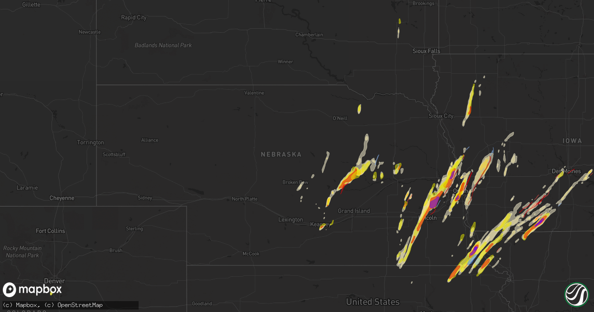
Hail Map in Nebraska on April 26, 2024
Get this storm
April 26 map
$229
one time, instant access
Download today. No call, no setup
Keep the $229
Bought the map and want the full workflow? Apply the entire $229 to a subscription within 7 days. None of it is wasted.
Every map, not just this one
This buys you this map. Subscription and you get every map we run, in the markets you choose from a few cities to whole states to nationwide. Plus real-time alerts the moment a storm fires.
Contact data
Name, contact info, occupancy, even credit band for addresses in the footprint. You go from where it hit to who to call.
Become the source they trust
Unlimited branding weather history reports on demand. You already have the documented answer ready for the property owner, and you are the one who showed up with it.
Property data and RoofTrace estimates
Pull up any address you have got, its value and the exact code rules for that jurisdiction, straight from One Click Code. Then RoofTrace estimates the squares, pitch, and roof value, priced the way you price.
Storm reports in Nebraska
Nebraska
| Date | Description |
|---|---|
| 04/26/20245:45 PM CDT | Delayed report. Emergency manager relayed report of a tornado near rulo over nawas. |
| 04/26/20245:20 PM CDT | Possible tornado. |
| 04/26/20245:20 PM CDT | Delayed report roof taken off athletic training center. |
| 04/26/20245:18 PM CDT | A local report indicates 58 MPH wind near 1 NNE Falls City |
| 04/26/20245:16 PM CDT | This brief ef1 tornado touched down near grandview road and east sherwood rood... Causing tree damage at a farmstead. The tornado moved northeast... Damaging large tree |
| 04/26/20245:10 PM CDT | Delayed report. Emergency management reported a tornado on the ground 2 miles north of salem... Nebraska. |
| 04/26/20245:02 PM CDT | A local report indicates 2.75 inch wind near Nemaha |
| 04/26/20244:58 PM CDT | This ef3 tornado developed just east of the eppley airfield runway system... About one-quarter mile west of the amelia earhart plaza and lindbergh plaza intersection. T |
| 04/26/20244:56 PM CDT | A local report indicates a tornado near 4 E Omaha |
| 04/26/20244:56 PM CDT | A local report indicates 1.00 inch wind near 1 ENE Papillion |
| 04/26/20244:55 PM CDT | A local report indicates 1.75 inch wind near 1 NW Carter Lake |
| 04/26/20244:55 PM CDT | A local report indicates 1.00 inch wind near 1 NNE Omaha |
| 04/26/20244:55 PM CDT | A local report indicates 1.75 inch wind near 5 NE Omaha |
| 04/26/20244:47 PM CDT | A local report indicates 1.50 inch wind near 1 SW Papillion |
| 04/26/20244:46 PM CDT | Report from mping: quarter |
| 04/26/20244:45 PM CDT | A local report indicates 2.00 inch wind near Papillion |
| 04/26/20244:43 PM CDT | Report from mping: golf ball |
| 04/26/20244:42 PM CDT | Report from mping: golf ball |
| 04/26/20244:40 PM CDT | A local report indicates 1.00 inch wind near 2 SSW Papillion |
| 04/26/20244:40 PM CDT | A local report indicates 1.00 inch wind near 1 WNW Ralston |
| 04/26/20244:30 PM CDT | A local report indicates 1.00 inch wind near 2 WSW La Vista |
| 04/26/20244:26 PM CDT | Report from mping: quarter |
| 04/26/20244:25 PM CDT | A local report indicates 1.00 inch wind near 1 WNW Valley |
| 04/26/20244:23 PM CDT | Multiple vortex tornado. |
| 04/26/20244:18 PM CDT | A local report indicates a tornado near 4 SE Blair |
| 04/26/20244:18 PM CDT | Building and tree damage to an abandoned farmstead. Delayed report. |
| 04/26/20244:16 PM CDT | Tornado on the ground south on 18th ave. |
| 04/26/20244:12 PM CDT | Report from mping: golf ball |
| 04/26/20244:10 PM CDT | A local report indicates a tornado near 4 SSE Blair |
| 04/26/20244:08 PM CDT | A local report indicates 1.25 inch wind near Blair |
| 04/26/20244:08 PM CDT | Destroyed homes. |
| 04/26/20244:05 PM CDT | Homes damaged. |
| 04/26/20244:00 PM CDT | Multiple homes destroyed. |
| 04/26/20243:59 PM CDT | A local report indicates a tornado near 2 NNW Bennington |
| 04/26/20243:55 PM CDT | Major structural damage to at least 10 homes. |
| 04/26/20243:52 PM CDT | Very large tornado near flanagan lake. |
| 04/26/20243:50 PM CDT | Tornado moving east. |
| 04/26/20243:49 PM CDT | Very large tornado near 204th and ida. |
| 04/26/20243:47 PM CDT | Emergency manager reported confirmed large tornado 4 to 5 miles west of newman grove. |
| 04/26/20243:47 PM CDT | Very large tornado moving through western elkhorn. |
| 04/26/20243:47 PM CDT | Very large tornado moving through western elkhorn. |
| 04/26/20243:45 PM CDT | Very large tornado moving into western elkhorn. |
| 04/26/20243:40 PM CDT | 240th and dodge. |
| 04/26/20243:39 PM CDT | House with severe roof damage. |
| 04/26/20243:37 PM CDT | Vehicle and building damage. |
| 04/26/20243:36 PM CDT | A local report indicates a tornado near 5 ESE Yutan |
| 04/26/20243:33 PM CDT | A local report indicates 1.00 inch wind near 1 WNW Valley |
| 04/26/20243:30 PM CDT | The ef3 tornado developed about one quarter mile west of the west q road and 255th st intersection in western douglas county where trees were knocked down and a farmste |
| 04/26/20243:30 PM CDT | A local report indicates a tornado near 5 ESE Yutan |
| 04/26/20243:29 PM CDT | Emergency manager reported a tornado on the ground 4 to 5 mile |
| 04/26/20243:29 PM CDT | Emergency manager reported a tornado on the ground 4 to 5 miles south of lindsay. |
| 04/26/20243:25 PM CDT | A local report indicates a tornado near 5 SE Yutan |
| 04/26/20243:15 PM CDT | Em relayed report from 911 call center of confirmed tornado to the west of ashland... Nebraska. |
| 04/26/20243:07 PM CDT | Trained spotter rep |
| 04/26/20243:07 PM CDT | Trained spotter reported a tornado just southwest of brainard... Nebraska. Tornado has since lifted but there are two additional funnel clouds currently. |
| 04/26/20243:06 PM CDT | Small rope tornado. |
| 04/26/20243:05 PM CDT | A local report indicates a tornado near 4 WNW Brainard |
| 04/26/20243:05 PM CDT | Report on facebook of quarter sized hail north of genoa. |
| 04/26/20243:02 PM CDT | Corrects previous hail report from 3 ese ceresco. Corrects previous hail report from 3 ese ceresco for wrong date. Delayed report from 4/26. |
| 04/26/20243:00 PM CDT | Social media photo of confirmed tornado 9 miles south of david city... Nebraska. |
| 04/26/20242:59 PM CDT | A local report indicates a tornado near 2 WNW Waverly |
| 04/26/20242:57 PM CDT | Train derailment hwy 6. Additional train derailment hwy 6 and i-480. Semi-rolled over. |
| 04/26/20242:55 PM CDT | 4 pivots overturned. 2 hog confinements destroyed. Delay report. |
| 04/26/20242:55 PM CDT | Building collapsed with people inside. Potential gas leak. |
| 04/26/20242:55 PM CDT | Numerous reports of damage near waverly... Including trains blown off tracks... Semis overturned. |
| 04/26/20242:54 PM CDT | Relayed from emergency management. |
| 04/26/20242:54 PM CDT | Delayed report time estimated by radar. |
| 04/26/20242:53 PM CDT | House damaged. |
| 04/26/20242:52 PM CDT | *** 3 inj *** this ef3 tornado touched down on the northeast side of lincoln near the intersection of havelock ave and 84th street causing damage to a business and a la |
| 04/26/20242:51 PM CDT | Building collapse. |
| 04/26/20242:50 PM CDT | A local report indicates a tornado near 5 NNE Lincoln |
| 04/26/20242:49 PM CDT | A local report indicates 1.25 inch wind near 6 SE Malcolm |
| 04/26/20242:48 PM CDT | Report from mping: golf ball |
| 04/26/20242:48 PM CDT | A local report indicates 1.75 inch wind near 5 NNW Lincoln |
| 04/26/20242:43 PM CDT | Brief tornado touchdown near the kawasaki plant. |
| 04/26/20242:41 PM CDT | A local report indicates 1.50 inch wind near 4 NW Lincoln |
| 04/26/20242:35 PM CDT | Butler county emergency manager reported golf ball sized hail in downtown ulysses. |
| 04/26/20242:27 PM CDT | Ground covered with hail. |
| 04/26/20242:24 PM CDT | Report of hail ranging from half an inch to an inch in denton... Ne. |
| 04/26/20242:15 PM CDT | A local report indicates 1.75 inch wind near 6 WSW Cedar Rapids |
| 04/26/20242:15 PM CDT | Report from mping: golf ball |
| 04/26/20242:00 PM CDT | Center pivot overturned... Tree and outbuilding damage... Road signs torn down. Delayed report. |
| 04/26/20241:32 PM CDT | This tornado touched down at 132 pm cdt 5 miles northeast of elba... And lifted at 154 pm cdt 3 miles north of wolbach. The rating was ef2... With an estimated peak win |
| 04/26/20241:30 PM CDT | A local report indicates 1.00 inch wind near 6 S Western |
| 04/26/20241:14 PM CDT | Emergency management reported power poles down near highway 11 and odell road. |
| 04/26/20241:14 PM CDT | Several reports of confirmed tornado west and north of elba. Time and location approximate pending damage survey. |
| 04/26/202412:58 PM CDT | This tornado touched down at 1258 pm cdt 1 mile south southeast of farwell... And lifted at 121 pm cdt 3 miles north of elba. This was the strongest tornado of the day |
| 04/26/202412:58 PM CDT | Reported by fireman. Moving north/northeast at the time. |
| 04/26/202412:38 PM CDT | Tornado confirmed with some damage report. Will update pending damage survey. |
| 04/26/202412:32 PM CDT | This tornado touched down at 1232 pm cdt 2 miles south of rockville... And lifted at 1248 pm cdt 4 miles north northeast of rockville. The rating was ef1... With an est |
| 04/26/202412:28 PM CDT | Location approximate. May be adjusted. Estimated on the ground for 4 to 5 minutes. Video confirmed. |
| 04/26/202412:25 PM CDT | Started to cover the ground with quarter to half-dollar size hail. |
| 04/26/202412:16 PM CDT | This tornado touched down at 1216 pm cdt 2 miles east southeast of ravenna... And lifted at 1231 pm cdt 3 miles north of ravenna. The rating was ef1... With an estimate |
| 04/26/202412:10 PM CDT | Also reports of dime to half-dollar size hail in ravenna. |
All States Impacted by Hail Map on April 26, 2024
Cities Impacted by Hail Map on April 26, 2024
- Newalla, OK
- Mcloud, OK
- Oktaha, OK
- Muskogee, OK
- Warner, OK
- Checotah, OK
- Porum, OK
- Fort Gibson, OK
- Braggs, OK
- Cherryvale, KS
- Neodesha, KS
- Thayer, KS
- Webbers Falls, OK
- Tahlequah, OK
- Gore, OK
- Broken Bow, NE
- Chanute, KS
- Altoona, KS
- Oconto, NE
- Vian, OK
- Park Hill, OK
- Cookson, OK
- Welling, OK
- Ansley, NE
- Lone Grove, OK
- Ardmore, OK
- Springer, OK
- Bunch, OK
- Comstock, NE
- Blanco, OK
- Pittsburg, OK
- Hartshorne, OK
- Mcalester, OK
- Kiowa, OK
- Savanna, OK
- Wilburton, OK
- Haileyville, OK
- Krebs, OK
- Quinton, OK
- Red Oak, OK
- Kinta, OK
- Mccurtain, OK
- Ord, NE
- Sulphur, OK
- Mill Creek, OK
- Elyria, NE
- Roff, OK
- Fitzhugh, OK
- Burwell, NE
- Stonewall, OK
- Mason, TX
- Valley Spring, TX
- Llano, TX
- Castell, TX
- Iredell, TX
- Glen Rose, TX
- Rainbow, TX
- Nemo, TX
- Walnut Springs, TX
- Cherokee, TX
- Cleburne, TX
- Granbury, TX
- Verdigre, NE
- Orchard, NE
- Tow, TX
- San Saba, TX
- Lampasas, TX
- Evant, TX
- Gatesville, TX
- Lometa, TX
- Kempner, TX
- Copperas Cove, TX
- Fort Worth, TX
- Aledo, TX
- Naval Air Station Jrb, TX
- Jonesboro, TX
- Purmela, TX
- Hamilton, TX
- Kopperl, TX
- Denton, TX
- Lake Dallas, TX
- Argyle, TX
- Lewisville, TX
- Little Elm, TX
- Meridian, TX
- Morgan, TX
- Hico, TX
- Cranfills Gap, TX
- Valley Mills, TX
- Aubrey, TX
- Elkins, AR
- Winslow, AR
- Ravenna, NE
- Oglesby, TX
- Crawford, TX
- Keene, TX
- Burleson, TX
- Joshua, TX
- Fayetteville, AR
- Crowley, TX
- Mansfield, TX
- Kennedale, TX
- Arlington, TX
- McGregor, TX
- Anthon, IA
- Oto, IA
- Huntsville, AR
- Wesley, AR
- Godley, TX
- Clifton, TX
- Alvarado, TX
- Bend, TX
- Grand Prairie, TX
- Correctionville, IA
- Pierson, IA
- Brayton, IA
- Exira, IA
- Atlantic, IA
- Rockville, NE
- Keller, TX
- Elk Horn, IA
- Harlan, IA
- Haslet, TX
- Euless, TX
- Washta, IA
- Marcus, IA
- Quimby, IA
- Cleghorn, IA
- China Spring, TX
- Waco, TX
- Audubon, IA
- Flower Mound, TX
- Irwin, IA
- Kimballton, IA
- Kirkman, IA
- West, TX
- Grapevine, TX
- Coppell, TX
- North Richland Hills, TX
- Southlake, TX
- Colleyville, TX
- Berryville, AR
- Adair, IA
- Guthrie Center, IA
- Hamlin, IA
- Meriden, IA
- Kearney, NE
- Coon Rapids, IA
- Narka, KS
- Ashton, NE
- Abbott, TX
- Hubbell, NE
- Reynolds, NE
- Axtell, NE
- Minden, NE
- Manning, IA
- Penelope, TX
- Elba, NE
- Farwell, NE
- Paullina, IA
- Sulphur Springs, TX
- Larrabee, IA
- Cherokee, IA
- Hebron, NE
- Fairbury, NE
- Mahaska, KS
- Van Alstyne, TX
- Whitney, TX
- Hillsboro, TX
- Omaha, AR
- Ridgedale, MO
- Hollister, MO
- Aquilla, TX
- Scotia, NE
- Frost, TX
- Cedarcreek, MO
- Kirbyville, MO
- Blum, TX
- Alexandria, NE
- Rio Vista, TX
- Tobias, NE
- Daykin, NE
- Friend, NE
- Jansen, NE
- Plymouth, NE
- Wolbach, NE
- Saint Paul, NE
- Gibbon, NE
- Shelton, NE
- Greeley, NE
- Purdon, TX
- Barry, TX
- Primghar, IA
- Kissee Mills, MO
- Rueter, MO
- Grandview, TX
- Covington, TX
- Pleasanton, NE
- Western, NE
- Swanton, NE
- Sutherland, IA
- Hartley, IA
- Exeter, NE
- Linn, KS
- Mount Vernon, TX
- De Witt, NE
- Beaver Crossing, NE
- Wilber, NE
- Crete, NE
- Bradleyville, MO
- Ava, MO
- Thornfield, MO
- Cordova, NE
- Milford, NE
- Pontotoc, TX
- Maple City, KS
- Arkansas City, KS
- Dexter, KS
- Corsicana, TX
- Denton, NE
- Pleasant Dale, NE
- Cambridge, KS
- Newkirk, OK
- Utica, NE
- Stringtown, OK
- Lane, OK
- Squires, MO
- Bynum, TX
- Atoka, OK
- Spalding, NE
- Lincoln, NE
- Martell, NE
- Cedar Rapids, NE
- Primrose, NE
- North Loup, NE
- Malone, TX
- Norwood, MO
- Drury, MO
- Seward, NE
- Daisy, OK
- Cedar Hill, TX
- Genoa, NE
- Saint Edward, NE
- Staplehurst, NE
- Ulysses, NE
- Cedar Vale, KS
- Grenola, KS
- Howard, KS
- Piedmont, KS
- Raymond, NE
- Malcolm, NE
- Mountain Grove, MO
- Vanzant, MO
- Severy, KS
- Fall River, KS
- Waverly, NE
- Davey, NE
- Ceresco, NE
- Dwight, NE
- Cabool, MO
- Mertens, TX
- Moline, KS
- Elk Falls, KS
- Greenwood, NE
- Ashland, NE
- Wahoo, NE
- Ithaca, NE
- David City, NE
- Mead, NE
- Albion, NE
- Elgin, NE
- Brainard, NE
- Salem, SD
- Yutan, NE
- Fredonia, KS
- Toronto, KS
- Waterloo, NE
- Valley, NE
- Winfred, SD
- Petersburg, NE
- Itasca, TX
- Clearwater, NE
- Oakdale, NE
- Neligh, NE
- Maypearl, TX
- Milford, TX
- Valparaiso, NE
- Longton, KS
- Elkhorn, NE
- Newman Grove, NE
- Ennis, TX
- Scroggins, TX
- Scurry, TX
- Rosser, TX
- Waxahachie, TX
- Bennington, NE
- Arlington, NE
- Kennard, NE
- Blooming Grove, TX
- Italy, TX
- Blair, NE
- Washington, NE
- Colon, NE
- Fremont, NE
- Leesburg, TX
- Winnsboro, TX
- Vermillion, KS
- Palmyra, NE
- Platte Center, NE
- Humphrey, NE
- Mount Pleasant, TX
- Winfield, TX
- Centralia, KS
- Baileyville, KS
- Columbus, NE
- Elmwood, NE
- Murdock, NE
- Weeping Water, NE
- Weston, NE
- Bristow, OK
- Mannford, OK
- Yates Center, KS
- Creston, NE
- Leigh, NE
- Benedict, KS
- Seneca, KS
- Sand Springs, OK
- Cleveland, OK
- Tulsa, OK
- Wills Point, TX
- Kemp, TX
- Steinauer, NE
- Table Rock, NE
- Pawnee City, NE
- Unadilla, NE
- Louisville, NE
- Buffalo, KS
- Pittsburg, TX
- Terrell, TX
- Sapulpa, OK
- Rising City, NE
- Rice, TX
- Chatfield, TX
- Kaufman, TX
- Mabank, TX
- Johnson, NE
- Brock, NE
- Auburn, NE
- Missouri Valley, IA
- Modale, IA
- Maywood, NE
- Holstein, NE
- Hayes Center, NE
- Haxtun, CO
- Fleming, CO
- Edgar, NE
- Eustis, NE
- Geneva, NE
- Ohiowa, NE
- Hastings, NE
- Cortland, NE
- Moorefield, NE
- Milligan, NE
- Sutton, NE
- Sterling, CO
- Stockville, NE
- Funk, NE
- Evans, CO
- Ayr, NE
- Sterling, NE
- Elwood, NE
- Champion, NE
- Kersey, CO
- Curtis, NE
- Adams, NE
- Greeley, CO
- Cook, NE
- Roseland, NE
- Holyoke, CO
- McCook, NE
- Akron, CO
- Bertrand, NE
- Clay Center, NE
- Glenvil, NE
- Clatonia, NE
- Wauneta, NE
- Firth, NE
- Holdrege, NE
- Snyder, CO
- Otis, CO
- Loomis, NE
- Merino, CO
- Shickley, NE
- Palisade, NE
- Enders, NE
- Imperial, NE
- Weldona, CO
- Bern, KS
- Du Bois, NE
- Humboldt, NE
- Dawson, NE
- Sperry, OK
- Skiatook, OK
- Edgewood, TX
- Springfield, NE
- Manley, NE
- Cedar Creek, NE
- Fruitvale, TX
- Elk Creek, NE
- Springdale, AR
- Siloam Springs, AR
- Point, TX
- Yantis, TX
- Emory, TX
- Lincoln, AR
- Herman, NE
- Humboldt, KS
- Nebraska City, NE
- Bellwood, NE
- La Vista, NE
- Papillion, NE
- Omaha, NE
- Mondamin, IA
- Bellevue, NE
- Julian, NE
- Talmage, NE
- Oneida, KS
- Sabetha, KS
- Como, TX
- Canton, TX
- Alba, TX
- Grand Saline, TX
- Plattsmouth, NE
- Union, NE
- Lindsay, NE
- Iola, KS
- La Harpe, KS
- Carter Lake, IA
- Crescent, IA
- Hamburg, IA
- Rock Port, MO
- Sidney, IA
- Council Bluffs, IA
- Palmer, TX
- Pacific Junction, IA
- Glenwood, IA
- Collinsville, OK
- Owasso, OK
- Peru, NE
- Gretna, NE
- Verdon, NE
- Salem, NE
- Stella, NE
- Shubert, NE
- Madison, NE
- Little Sioux, IA
- Pisgah, IA
- Pickton, TX
- Saltillo, TX
- Nemaha, NE
- Elsmore, KS
- Moran, KS
- Falls City, NE
- Tekamah, NE
- Honey Creek, IA
- Ben Wheeler, TX
- Van, TX
- Neola, IA
- McClelland, IA
- Uniontown, KS
- Bronson, KS
- Fort Calhoun, NE
- Silver Creek, NE
- Nash, TX
- Texarkana, TX
- Savonburg, KS
- Oologah, OK
- Claremore, OK
- Morrill, KS
- Brownville, NE
- Logan, IA
- Mineola, TX
- Lindale, TX
- Quitman, TX
- Soldier, IA
- Hiawatha, KS
- Underwood, IA
- Fairfax, MO
- Moorhead, IA
- Chelsea, OK
- Minden, IA
- Hawkins, TX
- Rulo, NE
- Craig, MO
- Shelby, IA
- Mapleton, KS
- Redfield, KS
- Fulton, KS
- White Cloud, KS
- Daingerfield, TX
- Omaha, TX
- Tarkio, MO
- Westboro, MO
- Naples, TX
- Blue Mound, KS
- Fort Scott, KS
- Prescott, KS
- Burlington Junction, MO
- Hughes Springs, TX
- Marietta, TX
- Linden, TX
- Douglassville, TX
- Simms, TX
- Portsmouth, IA
- Hume, MO
- Rich Hill, MO
- Trinidad, TX
- Big Cabin, OK
- Persia, IA
- Blanchard, IA
- Eustace, TX
- Coin, IA
- Northboro, IA
- Elmo, MO
- Clearmont, MO
- Vinita, OK
- Mound City, MO
- Atlanta, TX
- Hooks, TX
- Maud, TX
- New Boston, TX
- Gilmer, TX
- Westphalia, IA
- Earling, IA
- Defiance, IA
- Foster, MO
- Butler, MO
- Skidmore, MO
- Forest City, MO
- Panama, IA
- Okolona, AR
- Clarinda, IA
- College Springs, IA
- Braddyville, IA
- Shambaugh, IA
- Malakoff, TX
- Queen City, TX
- Maitland, MO
- Texarkana, AR
- Fouke, AR
- Treynor, IA
- Manilla, IA
- Nodaway, IA
- New Market, IA
- Oregon, MO
- Arkadelphia, AR
- Villisca, IA
- Bedford, IA
- Amity, AR
- Lenox, IA
- Benton, AR
- Kincaid, KS
- Donaldson, AR
- Friendship, AR
- Bismarck, AR
- Gravity, IA
- Lonsdale, AR
- Hot Springs National Park, AR
- Malvern, AR
- Hot Springs Village, AR
- Corning, IA
- Garland City, AR
- Fulton, AR
- Lewisville, AR
- Hope, AR
- Denison, IA
- Alexander, AR
- Little Rock, AR
- Paron, AR
- Sharpsburg, IA
- Prescott, IA
- Mound City, KS
- Creston, IA
- Cromwell, IA
- Roland, AR
- Littleton, CO
- Sheridan, MO
- Grant City, MO
- Redding, IA
- Blockton, IA
- Afton, IA
- Avoca, IA
- Pleasanton, KS
- Maumelle, AR
- Ramona, OK
- Mayflower, AR
- Massena, IA
- Conway, AR
- Hancock, IA
- Pickering, MO
- Maryville, MO
- Hopkins, MO
- Mount Ayr, IA
- North Little Rock, AR
- Sherwood, AR
- Aspinwall, IA
- Arcadia, IA
- Westside, IA
- Lorimor, IA
- Morrison, CO
- Fontanelle, IA
- Kellerton, IA
- Tingley, IA
- Ellston, IA
- Cabot, AR
- Jacksonville, AR
- Little Rock Air Force Base, AR
- Carroll, IA
- Breda, IA
- Cookville, TX
- Winterset, IA
- Auburn, IA
- Lake City, IA
- Peru, IA
- Ward, AR
- McRae, AR
- Austin, AR
- Beebe, AR
- Clearfield, IA
- Diagonal, IA
- Benton, IA
- Cumming, IA
- Van Meter, IA
- Prole, IA
- Grand River, IA
- Murray, IA
- Searcy, AR
- Garner, AR
- Osceola, IA
- Shannon City, IA
- Des Moines, IA
- Pleasant Hill, IA
- Altoona, IA
- New Virginia, IA
- West Des Moines, IA
- Indianola, IA
- De Kalb, TX
- Ackworth, IA
- Milo, IA
- Gibsland, LA
- Thayer, IA
- Swan, IA
- Athens, LA
- Carlisle, IA
- Ravenwood, MO
- Parnell, MO
- Pleasantville, IA
- Runnells, IA
- Prairie City, IA
- Monroe, IA
- Hartford, IA
- Monticello, AR
- Homer, LA
- Minden, LA
- Ashdown, AR
- Foreman, AR
- Newton, IA
- Farmerville, LA
- Macksburg, IA
- Marion, LA
- Windsor Heights, IA
- Fort Towson, OK
- Clive, IA
- Urbandale, IA
- Huttig, AR
- Ringold, OK
- Rattan, OK
- Rufe, OK
- Valliant, OK
- Broken Bow, OK
- Hermitage, AR
- Hamburg, AR
- Crossett, AR
- Ramona, SD
- Otley, IA
- Fountain Hill, AR
- Bethel, OK
- Smithville, OK
- Honobia, OK
- Matador, TX
- Appleton City, MO
- Clinton, MO
- Norfolk, NE
- Stanton, NE


