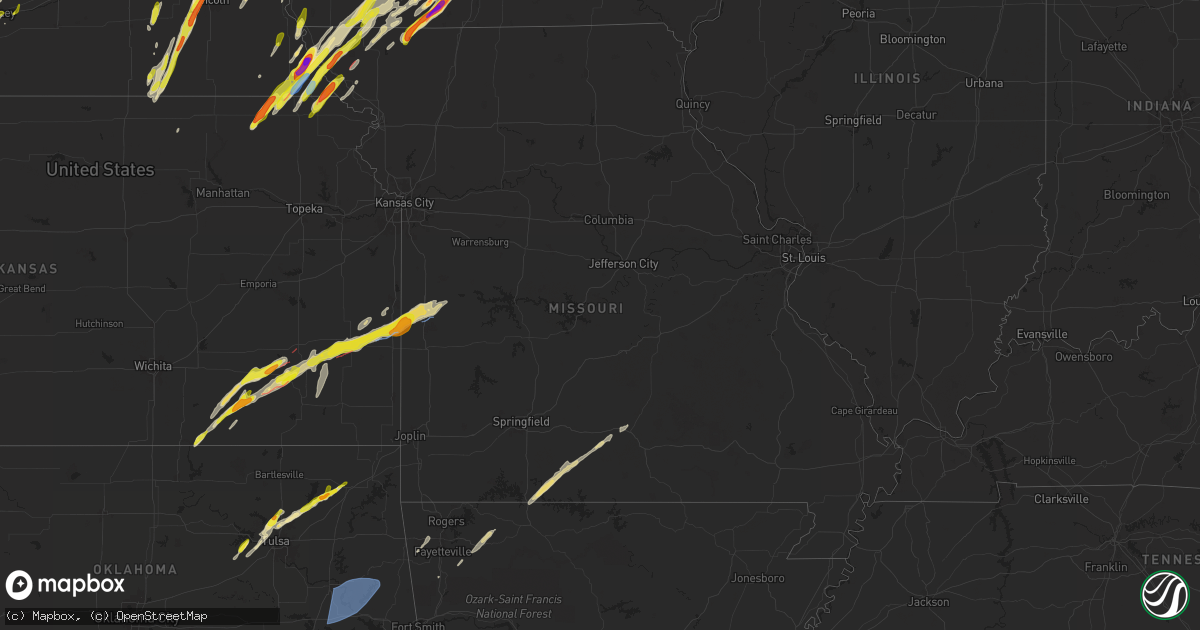
Hail Map in Missouri on April 26, 2024
Get this storm
April 26 map
$229
one time, instant access
Download today. No call, no setup
Keep the $229
Bought the map and want the full workflow? Apply the entire $229 to a subscription within 7 days. None of it is wasted.
Every map, not just this one
This buys you this map. Subscription and you get every map we run, in the markets you choose from a few cities to whole states to nationwide. Plus real-time alerts the moment a storm fires.
Contact data
Name, contact info, occupancy, even credit band for addresses in the footprint. You go from where it hit to who to call.
Become the source they trust
Unlimited branding weather history reports on demand. You already have the documented answer ready for the property owner, and you are the one who showed up with it.
Property data and RoofTrace estimates
Pull up any address you have got, its value and the exact code rules for that jurisdiction, straight from One Click Code. Then RoofTrace estimates the squares, pitch, and roof value, priced the way you price.
Storm reports in Missouri
Missouri
| Date | Description |
|---|---|
| 04/26/20246:53 PM CDT | Damage to a structure near appleton city lake. Time estimated from radar. |
| 04/26/20246:53 PM CDT | Downed trees blocking highway 52 west of appleton city near the st. Clair county line. Time estimated from radar. |
| 04/26/20246:42 PM CDT | Nws damage survey confirmed a brief ef-0 tornado southwest of appleton city... Mo the evening of the 26th of april... 2024. Minor damage to trees along the path. |
| 04/26/20246:36 PM CDT | Fire department reported a tornado east of rich hill. Time and location estimated from radar. |
| 04/26/20246:14 PM CDT | Fire dept. Reported weak tornado. |
| 04/26/20246:07 PM CDT | An ef-1 tornado occurred... With a path length of 3.4 miles and a width of 95 yards. Maximum wind speeds of 95 mph destroyed two outbuildings... And caused a number of |
| 04/26/20246:03 PM CDT | Photo of approximately ping pong ball size hail in hume relayed to nws employee. Time estimated from radar. |
| 04/26/20245:38 PM CDT | Em reported quarter-sized hail at hwy 59 and holt county line. |
| 04/26/20245:38 PM CDT | Em reported quarter-sized hail at hwy 59 and holt county line |
| 04/26/20245:30 PM CDT | Social media report of quarter size hail. Time estimated from radar. |
| 04/25/20247:34 PM CDT | Nws damage survey confirms a very brief ef-0 tornado southeast of clinton... Mo. Damage to two outbuildings. |
| 04/25/20247:23 PM CDT | Tornado developed near highway e west of u.s. Highway 169... Causing minor damage to a residence. Tornado tracked northeastward into iowa. Time estimated from radar. |
| 04/25/20247:12 PM CDT | Photo relayed of golf ball size hail in worth county. Time and location estimated from radar. |
All States Impacted by Hail Map on April 26, 2024
Cities Impacted by Hail Map on April 26, 2024
- Newalla, OK
- Mcloud, OK
- Oktaha, OK
- Muskogee, OK
- Warner, OK
- Checotah, OK
- Porum, OK
- Fort Gibson, OK
- Braggs, OK
- Cherryvale, KS
- Neodesha, KS
- Thayer, KS
- Webbers Falls, OK
- Tahlequah, OK
- Gore, OK
- Broken Bow, NE
- Chanute, KS
- Altoona, KS
- Oconto, NE
- Vian, OK
- Park Hill, OK
- Cookson, OK
- Welling, OK
- Ansley, NE
- Lone Grove, OK
- Ardmore, OK
- Springer, OK
- Bunch, OK
- Comstock, NE
- Blanco, OK
- Pittsburg, OK
- Hartshorne, OK
- Mcalester, OK
- Kiowa, OK
- Savanna, OK
- Wilburton, OK
- Haileyville, OK
- Krebs, OK
- Quinton, OK
- Red Oak, OK
- Kinta, OK
- Mccurtain, OK
- Ord, NE
- Sulphur, OK
- Mill Creek, OK
- Elyria, NE
- Roff, OK
- Fitzhugh, OK
- Burwell, NE
- Stonewall, OK
- Mason, TX
- Valley Spring, TX
- Llano, TX
- Castell, TX
- Iredell, TX
- Glen Rose, TX
- Rainbow, TX
- Nemo, TX
- Walnut Springs, TX
- Cherokee, TX
- Cleburne, TX
- Granbury, TX
- Verdigre, NE
- Orchard, NE
- Tow, TX
- San Saba, TX
- Lampasas, TX
- Evant, TX
- Gatesville, TX
- Lometa, TX
- Kempner, TX
- Copperas Cove, TX
- Fort Worth, TX
- Aledo, TX
- Naval Air Station Jrb, TX
- Jonesboro, TX
- Purmela, TX
- Hamilton, TX
- Kopperl, TX
- Denton, TX
- Lake Dallas, TX
- Argyle, TX
- Lewisville, TX
- Little Elm, TX
- Meridian, TX
- Morgan, TX
- Hico, TX
- Cranfills Gap, TX
- Valley Mills, TX
- Aubrey, TX
- Elkins, AR
- Winslow, AR
- Ravenna, NE
- Oglesby, TX
- Crawford, TX
- Keene, TX
- Burleson, TX
- Joshua, TX
- Fayetteville, AR
- Crowley, TX
- Mansfield, TX
- Kennedale, TX
- Arlington, TX
- McGregor, TX
- Anthon, IA
- Oto, IA
- Huntsville, AR
- Wesley, AR
- Godley, TX
- Clifton, TX
- Alvarado, TX
- Bend, TX
- Grand Prairie, TX
- Correctionville, IA
- Pierson, IA
- Brayton, IA
- Exira, IA
- Atlantic, IA
- Rockville, NE
- Keller, TX
- Elk Horn, IA
- Harlan, IA
- Haslet, TX
- Euless, TX
- Washta, IA
- Marcus, IA
- Quimby, IA
- Cleghorn, IA
- China Spring, TX
- Waco, TX
- Audubon, IA
- Flower Mound, TX
- Irwin, IA
- Kimballton, IA
- Kirkman, IA
- West, TX
- Grapevine, TX
- Coppell, TX
- North Richland Hills, TX
- Southlake, TX
- Colleyville, TX
- Berryville, AR
- Adair, IA
- Guthrie Center, IA
- Hamlin, IA
- Meriden, IA
- Kearney, NE
- Coon Rapids, IA
- Narka, KS
- Ashton, NE
- Abbott, TX
- Hubbell, NE
- Reynolds, NE
- Axtell, NE
- Minden, NE
- Manning, IA
- Penelope, TX
- Elba, NE
- Farwell, NE
- Paullina, IA
- Sulphur Springs, TX
- Larrabee, IA
- Cherokee, IA
- Hebron, NE
- Fairbury, NE
- Mahaska, KS
- Van Alstyne, TX
- Whitney, TX
- Hillsboro, TX
- Omaha, AR
- Ridgedale, MO
- Hollister, MO
- Aquilla, TX
- Scotia, NE
- Frost, TX
- Cedarcreek, MO
- Kirbyville, MO
- Blum, TX
- Alexandria, NE
- Rio Vista, TX
- Tobias, NE
- Daykin, NE
- Friend, NE
- Jansen, NE
- Plymouth, NE
- Wolbach, NE
- Saint Paul, NE
- Gibbon, NE
- Shelton, NE
- Greeley, NE
- Purdon, TX
- Barry, TX
- Primghar, IA
- Kissee Mills, MO
- Rueter, MO
- Grandview, TX
- Covington, TX
- Pleasanton, NE
- Western, NE
- Swanton, NE
- Sutherland, IA
- Hartley, IA
- Exeter, NE
- Linn, KS
- Mount Vernon, TX
- De Witt, NE
- Beaver Crossing, NE
- Wilber, NE
- Crete, NE
- Bradleyville, MO
- Ava, MO
- Thornfield, MO
- Cordova, NE
- Milford, NE
- Pontotoc, TX
- Maple City, KS
- Arkansas City, KS
- Dexter, KS
- Corsicana, TX
- Denton, NE
- Pleasant Dale, NE
- Cambridge, KS
- Newkirk, OK
- Utica, NE
- Stringtown, OK
- Lane, OK
- Squires, MO
- Bynum, TX
- Atoka, OK
- Spalding, NE
- Lincoln, NE
- Martell, NE
- Cedar Rapids, NE
- Primrose, NE
- North Loup, NE
- Malone, TX
- Norwood, MO
- Drury, MO
- Seward, NE
- Daisy, OK
- Cedar Hill, TX
- Genoa, NE
- Saint Edward, NE
- Staplehurst, NE
- Ulysses, NE
- Cedar Vale, KS
- Grenola, KS
- Howard, KS
- Piedmont, KS
- Raymond, NE
- Malcolm, NE
- Mountain Grove, MO
- Vanzant, MO
- Severy, KS
- Fall River, KS
- Waverly, NE
- Davey, NE
- Ceresco, NE
- Dwight, NE
- Cabool, MO
- Mertens, TX
- Moline, KS
- Elk Falls, KS
- Greenwood, NE
- Ashland, NE
- Wahoo, NE
- Ithaca, NE
- David City, NE
- Mead, NE
- Albion, NE
- Elgin, NE
- Brainard, NE
- Salem, SD
- Yutan, NE
- Fredonia, KS
- Toronto, KS
- Waterloo, NE
- Valley, NE
- Winfred, SD
- Petersburg, NE
- Itasca, TX
- Clearwater, NE
- Oakdale, NE
- Neligh, NE
- Maypearl, TX
- Milford, TX
- Valparaiso, NE
- Longton, KS
- Elkhorn, NE
- Newman Grove, NE
- Ennis, TX
- Scroggins, TX
- Scurry, TX
- Rosser, TX
- Waxahachie, TX
- Bennington, NE
- Arlington, NE
- Kennard, NE
- Blooming Grove, TX
- Italy, TX
- Blair, NE
- Washington, NE
- Colon, NE
- Fremont, NE
- Leesburg, TX
- Winnsboro, TX
- Vermillion, KS
- Palmyra, NE
- Platte Center, NE
- Humphrey, NE
- Mount Pleasant, TX
- Winfield, TX
- Centralia, KS
- Baileyville, KS
- Columbus, NE
- Elmwood, NE
- Murdock, NE
- Weeping Water, NE
- Weston, NE
- Bristow, OK
- Mannford, OK
- Yates Center, KS
- Creston, NE
- Leigh, NE
- Benedict, KS
- Seneca, KS
- Sand Springs, OK
- Cleveland, OK
- Tulsa, OK
- Wills Point, TX
- Kemp, TX
- Steinauer, NE
- Table Rock, NE
- Pawnee City, NE
- Unadilla, NE
- Louisville, NE
- Buffalo, KS
- Pittsburg, TX
- Terrell, TX
- Sapulpa, OK
- Rising City, NE
- Rice, TX
- Chatfield, TX
- Kaufman, TX
- Mabank, TX
- Johnson, NE
- Brock, NE
- Auburn, NE
- Missouri Valley, IA
- Modale, IA
- Maywood, NE
- Holstein, NE
- Hayes Center, NE
- Haxtun, CO
- Fleming, CO
- Edgar, NE
- Eustis, NE
- Geneva, NE
- Ohiowa, NE
- Hastings, NE
- Cortland, NE
- Moorefield, NE
- Milligan, NE
- Sutton, NE
- Sterling, CO
- Stockville, NE
- Funk, NE
- Evans, CO
- Ayr, NE
- Sterling, NE
- Elwood, NE
- Champion, NE
- Kersey, CO
- Curtis, NE
- Adams, NE
- Greeley, CO
- Cook, NE
- Roseland, NE
- Holyoke, CO
- McCook, NE
- Akron, CO
- Bertrand, NE
- Clay Center, NE
- Glenvil, NE
- Clatonia, NE
- Wauneta, NE
- Firth, NE
- Holdrege, NE
- Snyder, CO
- Otis, CO
- Loomis, NE
- Merino, CO
- Shickley, NE
- Palisade, NE
- Enders, NE
- Imperial, NE
- Weldona, CO
- Bern, KS
- Du Bois, NE
- Humboldt, NE
- Dawson, NE
- Sperry, OK
- Skiatook, OK
- Edgewood, TX
- Springfield, NE
- Manley, NE
- Cedar Creek, NE
- Fruitvale, TX
- Elk Creek, NE
- Springdale, AR
- Siloam Springs, AR
- Point, TX
- Yantis, TX
- Emory, TX
- Lincoln, AR
- Herman, NE
- Humboldt, KS
- Nebraska City, NE
- Bellwood, NE
- La Vista, NE
- Papillion, NE
- Omaha, NE
- Mondamin, IA
- Bellevue, NE
- Julian, NE
- Talmage, NE
- Oneida, KS
- Sabetha, KS
- Como, TX
- Canton, TX
- Alba, TX
- Grand Saline, TX
- Plattsmouth, NE
- Union, NE
- Lindsay, NE
- Iola, KS
- La Harpe, KS
- Carter Lake, IA
- Crescent, IA
- Hamburg, IA
- Rock Port, MO
- Sidney, IA
- Council Bluffs, IA
- Palmer, TX
- Pacific Junction, IA
- Glenwood, IA
- Collinsville, OK
- Owasso, OK
- Peru, NE
- Gretna, NE
- Verdon, NE
- Salem, NE
- Stella, NE
- Shubert, NE
- Madison, NE
- Little Sioux, IA
- Pisgah, IA
- Pickton, TX
- Saltillo, TX
- Nemaha, NE
- Elsmore, KS
- Moran, KS
- Falls City, NE
- Tekamah, NE
- Honey Creek, IA
- Ben Wheeler, TX
- Van, TX
- Neola, IA
- McClelland, IA
- Uniontown, KS
- Bronson, KS
- Fort Calhoun, NE
- Silver Creek, NE
- Nash, TX
- Texarkana, TX
- Savonburg, KS
- Oologah, OK
- Claremore, OK
- Morrill, KS
- Brownville, NE
- Logan, IA
- Mineola, TX
- Lindale, TX
- Quitman, TX
- Soldier, IA
- Hiawatha, KS
- Underwood, IA
- Fairfax, MO
- Moorhead, IA
- Chelsea, OK
- Minden, IA
- Hawkins, TX
- Rulo, NE
- Craig, MO
- Shelby, IA
- Mapleton, KS
- Redfield, KS
- Fulton, KS
- White Cloud, KS
- Daingerfield, TX
- Omaha, TX
- Tarkio, MO
- Westboro, MO
- Naples, TX
- Blue Mound, KS
- Fort Scott, KS
- Prescott, KS
- Burlington Junction, MO
- Hughes Springs, TX
- Marietta, TX
- Linden, TX
- Douglassville, TX
- Simms, TX
- Portsmouth, IA
- Hume, MO
- Rich Hill, MO
- Trinidad, TX
- Big Cabin, OK
- Persia, IA
- Blanchard, IA
- Eustace, TX
- Coin, IA
- Northboro, IA
- Elmo, MO
- Clearmont, MO
- Vinita, OK
- Mound City, MO
- Atlanta, TX
- Hooks, TX
- Maud, TX
- New Boston, TX
- Gilmer, TX
- Westphalia, IA
- Earling, IA
- Defiance, IA
- Foster, MO
- Butler, MO
- Skidmore, MO
- Forest City, MO
- Panama, IA
- Okolona, AR
- Clarinda, IA
- College Springs, IA
- Braddyville, IA
- Shambaugh, IA
- Malakoff, TX
- Queen City, TX
- Maitland, MO
- Texarkana, AR
- Fouke, AR
- Treynor, IA
- Manilla, IA
- Nodaway, IA
- New Market, IA
- Oregon, MO
- Arkadelphia, AR
- Villisca, IA
- Bedford, IA
- Amity, AR
- Lenox, IA
- Benton, AR
- Kincaid, KS
- Donaldson, AR
- Friendship, AR
- Bismarck, AR
- Gravity, IA
- Lonsdale, AR
- Hot Springs National Park, AR
- Malvern, AR
- Hot Springs Village, AR
- Corning, IA
- Garland City, AR
- Fulton, AR
- Lewisville, AR
- Hope, AR
- Denison, IA
- Alexander, AR
- Little Rock, AR
- Paron, AR
- Sharpsburg, IA
- Prescott, IA
- Mound City, KS
- Creston, IA
- Cromwell, IA
- Roland, AR
- Littleton, CO
- Sheridan, MO
- Grant City, MO
- Redding, IA
- Blockton, IA
- Afton, IA
- Avoca, IA
- Pleasanton, KS
- Maumelle, AR
- Ramona, OK
- Mayflower, AR
- Massena, IA
- Conway, AR
- Hancock, IA
- Pickering, MO
- Maryville, MO
- Hopkins, MO
- Mount Ayr, IA
- North Little Rock, AR
- Sherwood, AR
- Aspinwall, IA
- Arcadia, IA
- Westside, IA
- Lorimor, IA
- Morrison, CO
- Fontanelle, IA
- Kellerton, IA
- Tingley, IA
- Ellston, IA
- Cabot, AR
- Jacksonville, AR
- Little Rock Air Force Base, AR
- Carroll, IA
- Breda, IA
- Cookville, TX
- Winterset, IA
- Auburn, IA
- Lake City, IA
- Peru, IA
- Ward, AR
- McRae, AR
- Austin, AR
- Beebe, AR
- Clearfield, IA
- Diagonal, IA
- Benton, IA
- Cumming, IA
- Van Meter, IA
- Prole, IA
- Grand River, IA
- Murray, IA
- Searcy, AR
- Garner, AR
- Osceola, IA
- Shannon City, IA
- Des Moines, IA
- Pleasant Hill, IA
- Altoona, IA
- New Virginia, IA
- West Des Moines, IA
- Indianola, IA
- De Kalb, TX
- Ackworth, IA
- Milo, IA
- Gibsland, LA
- Thayer, IA
- Swan, IA
- Athens, LA
- Carlisle, IA
- Ravenwood, MO
- Parnell, MO
- Pleasantville, IA
- Runnells, IA
- Prairie City, IA
- Monroe, IA
- Hartford, IA
- Monticello, AR
- Homer, LA
- Minden, LA
- Ashdown, AR
- Foreman, AR
- Newton, IA
- Farmerville, LA
- Macksburg, IA
- Marion, LA
- Windsor Heights, IA
- Fort Towson, OK
- Clive, IA
- Urbandale, IA
- Huttig, AR
- Ringold, OK
- Rattan, OK
- Rufe, OK
- Valliant, OK
- Broken Bow, OK
- Hermitage, AR
- Hamburg, AR
- Crossett, AR
- Ramona, SD
- Otley, IA
- Fountain Hill, AR
- Bethel, OK
- Smithville, OK
- Honobia, OK
- Matador, TX
- Appleton City, MO
- Clinton, MO
- Norfolk, NE
- Stanton, NE


