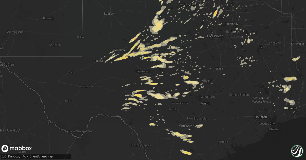
Hail Map in Texas on April 26, 2016
Get this storm
April 26 map
$229
one time, instant access
Download today. No call, no setup
Keep the $229
Bought the map and want the full workflow? Apply the entire $229 to a subscription within 7 days. None of it is wasted.
Every map, not just this one
This buys you this map. Subscription and you get every map we run, in the markets you choose from a few cities to whole states to nationwide. Plus real-time alerts the moment a storm fires.
Contact data
Name, contact info, occupancy, even credit band for addresses in the footprint. You go from where it hit to who to call.
Become the source they trust
Unlimited branding weather history reports on demand. You already have the documented answer ready for the property owner, and you are the one who showed up with it.
Property data and RoofTrace estimates
Pull up any address you have got, its value and the exact code rules for that jurisdiction, straight from One Click Code. Then RoofTrace estimates the squares, pitch, and roof value, priced the way you price.
Storm reports in Texas
Texas
| Date | Description |
|---|---|
| 04/26/20166:59 PM CDT | A local report indicates 1.00 inch wind near 2 N DRASCO |
| 04/26/20166:56 PM CDT | Quarter size hail was reported |
| 04/26/20166:50 PM CDT | A local report indicates 1.00 inch wind near ABILENE |
| 04/26/20166:43 PM CDT | The abilene regional airport asos recorded a 55 knot wind gust...64 mph |
| 04/26/20166:42 PM CDT | A local report indicates 70 MPH wind near BUFFALO GAP |
| 04/26/20166:38 PM CDT | A local report indicates 70 MPH wind near 4 N THROCKMORTON |
| 04/26/20166:02 PM CDT | A lot of golfball size hail was reported in haskell. |
| 04/26/20165:52 PM CDT | A stormchaser took a picture of this tornado from stamford. The tornado became quickly wrapped up in rain. |
| 04/26/20165:45 PM CDT | Half dollar size hail was reported |
| 04/26/20165:35 PM CDT | Wind damage was reported in hamlin...including several trees down. |
| 04/26/20165:32 PM CDT | A local report indicates 1.00 inch wind near 1 W SWEETWATER |
| 04/26/20165:17 PM CDT | A local report indicates 1.00 inch wind near 7 SW ROSCOE |
| 04/26/20165:17 PM CDT | A local report indicates 1.75 inch wind near 3 NE CHILLICOTHE |
| 04/26/20165:17 PM CDT | A local report indicates 1.75 inch wind near 3 S CHILLICOTHE |
| 04/26/20165:15 PM CDT | Golf ball size hail along highway 87 |
| 04/26/20165:10 PM CDT | A local report indicates 1.00 inch wind near 6 SW CHILLICOTHE |
| 04/26/20164:48 PM CDT | South part of town. |
| 04/26/20164:35 PM CDT | A local report indicates 1.00 inch wind near GARDEN CITY |
| 04/26/20164:27 PM CDT | A local report indicates 1.75 inch wind near 14 N VERNON |
| 04/26/20164:22 PM CDT | At fm 644 and us 84. |
| 04/26/20164:21 PM CDT | A local report indicates 1.75 inch wind near 7 N VERNON |
| 04/26/20163:55 PM CDT | A local report indicates 58 MPH wind near 14 SSW PAMPA |
| 04/26/20163:35 PM CDT | A local report indicates 1.75 inch wind near CROWELL |
| 04/26/20163:30 PM CDT | A local report indicates 2.50 inch wind near CROWELL |
| 04/26/20166:45 AM CDT | 5w tatum tree across roadway at 1716 and fm 782 |
| 04/26/20166:44 AM CDT | Multiple trees down around van buren elementary and near by streets in groves. |
| 04/26/20166:41 AM CDT | 3ne henderson tree broken over roadway cr 236 e henderson 1/4 mile off 322 |
| 04/26/20166:32 AM CDT | Public posted photo of a tree that fell on a truck in kirbyville. Time estimated. |
| 04/26/20166:25 AM CDT | A tree fell onto a house near college and 2nd st in jasper. |
| 04/26/20166:24 AM CDT | *** 1 inj *** lake rayburn fd extracted individual pinned in bed by fallen pine tree. Individual transported to nearby hospital. |
| 04/26/20166:22 AM CDT | Broadcast media posted photos of uprooted and snapped trees which damaged two homes in magnolia springs. Time estimated. |
| 04/26/20166:22 AM CDT | 3w tatum tree across sb lane 3 miles west of tatum at fm 1797 |
| 04/26/20166:22 AM CDT | The ef1 tornado touched down just west of fm 1005 north of magnolia springs where it uprooted and snapped several trees. A home along fm 1005 was damaged when a tree fe |
| 04/26/20166:16 AM CDT | Public measured 62 mph wind gust on anometer mounted on pole in open portion of yard. |
| 04/26/20166:05 AM CDT | Numerous trees damaged and widespread power outages across hardin county. |
| 04/26/20165:58 AM CDT | The ef1 tornado touched down southeast of woodville near highway 287 where tree fall displayed greater convergence and some roofing material was removed from a building |
| 04/26/20165:55 AM CDT | Numerous trees damaged and widespread power outages in woodville and across tyler county. |
| 04/26/20165:54 AM CDT | Widespread wind damage between ivanhoe and woodville. |
| 04/26/20165:52 AM CDT | Roofing material removed and windows blown out of a building near the intersection of hwy 69 and north charlton. |
| 04/26/20165:50 AM CDT | *** 1 inj *** trees down and one injury reported by assistant em. |
| 04/26/20165:50 AM CDT | On the alabama-coushatta indian reservation there are trees snapped along fm 190 and in a trailer park. |
| 04/26/20165:35 AM CDT | 3w tatum large tree blocking both sides of road at fm 1797 and fm 782 |
| 04/26/20165:26 AM CDT | Correction... There was no window damage east of the town of livingston. |
| 04/26/20165:24 AM CDT | Large tree down on truck and garage ancient oaks drive. |
| 04/26/20165:24 AM CDT | 4ene henderson tree down across fm 3135 and county road 265 |
| 04/26/20165:15 AM CDT | Trees down on memorial drive one block west of wescott. |
| 04/26/20165:06 AM CDT | Large trees down |
| 04/26/20164:58 AM CDT | 0453 lt thunderstorm wind gust at cxo. |
| 04/26/20164:49 AM CDT | *** 1 fatal *** a downed tree onto a mobile home killed an elderly female in tomball. |
| 04/26/20164:48 AM CDT | 4 large pine trees blown down by straight line winds at 23015 holly hollow tomball. |
| 04/26/20164:48 AM CDT | Large tree down on fm 1097. Car struck tree lying in the roadway. No injuries. |
| 04/26/20164:45 AM CDT | On the alabama-coushatta indian reservation there are trees snapped along fm 190 and in a trailer park. |
| 04/26/20164:45 AM CDT | Reports of numerous trees downed...residential damage...power outtages from a magnolia to montgomery to willis line. |
| 04/26/20164:40 AM CDT | Numerous trees reported downed. |
| 04/26/20164:30 AM CDT | Trees and power lines down near oak hollow and fm1488 |
| 04/26/20164:27 AM CDT | 3e henderson... Tree down across roadway 1 mile off hwy 79 on fm 348 |
| 04/26/20164:03 AM CDT | Sheriff department reports tree down across us hwy 69...just south of the city of rusk. |
| 04/26/20164:03 AM CDT | Sheriff department reports tree down on us hwy 69 near the seven mile hill area...between the cities of jacksonville and rusk. |
| 04/26/20164:00 AM CDT | Sheriff department reports road closure on fm road 747...4 miles south of us hwy 79...due to large tree across the road. |
| 04/26/20163:30 AM CDT | Some trees down around the county. |
| 04/26/20163:01 AM CDT | Trees and power lines downed as thunderstorm wind gusts of approx. 60 mph moved across north austin. |
| 04/26/20162:45 AM CDT | Thunderstorm wind gusts were strong enough to send a trampoline flying so hard it literally stuck into the exterior composite panel siding of a home |
| 04/26/20162:45 AM CDT | Large tree limbs and branches broken...all greater than two inches in diameter |
| 04/26/20162:40 AM CDT | Thunderstorm wind gusts uprooted a large 12 to 15 inch diameter trunk tree near fm2222 and north mopac expressway |
| 04/26/20162:40 AM CDT | Large ten to 14 inch diameter trunk size tree toppled onto fencing and metal storage shed on wind river road in mesa park due to high winds |
| 04/26/20162:40 AM CDT | Trees down in several locations around brazos county...at elmo weedon and brookwood...fm 1179 and grassbur road...dick elliott and osr...old bundick and macey road...fm |
| 04/26/20162:40 AM CDT | Multiple reports via social media of large trees downed by wind gusts |
| 04/26/20162:39 AM CDT | A local report indicates 67 MPH wind near 3 ENE PFLUGERVILLE |
| 04/26/20162:36 AM CDT | Trees down at 4106 old hearne road...fm 1179 and boonville...north texas avenue. |
| 04/26/20162:35 AM CDT | Large ten inch diameter tree toppled onto fencing by wind gusts near rain creek pkwy and floral park dr |
| 04/26/20162:19 AM CDT | Wind gust measured at the ut lake travis test station by a davis weather system. |
| 04/26/20162:15 AM CDT | Large trees downed by wind gusts near fm1888 and crabapple road |
| 04/26/20162:00 AM CDT | Metal roof panels stripped from horse arena...metal roof panels stripped from a home...large trees downed by wind gusts |
| 04/26/20161:45 AM CDT | Large trees downed by wind gusts near north state highway 16 and farm road 1323 |
| 04/26/20161:40 AM CDT | Large trees downed by wind gusts near highway 16 and fm965 |
| 04/26/20161:30 AM CDT | Several large trees downed by thunderstorm wind gusts near the intersection of fm965 and land ranch road which is about three miles south southwest of enchanted rock st |
| 04/26/20161:20 AM CDT | Large trees downed by wind gusts near north ranch road 783 and lange road |
| 04/26/20161:15 AM CDT | A number of trees were downed across several roads throughout smith county. Power lines were downed as well...resulting in large power outages especially in the lindale |
| 04/26/20161:10 AM CDT | Picture of a small tree down in lindale posted to kltv's facebook page. |
| 04/26/20161:00 AM CDT | Trees...power lines...and power poles were downed along fm 16 east of county road 479. |
| 04/26/20161:00 AM CDT | Trees and power lines down on oak drive just northwest of lindale. |
| 04/26/201612:58 AM CDT | A very large tree limb was blown down onto a home on newsom street in mineola...resulting in roof damage. |
| 04/26/201612:30 AM CDT | Delayed report---law enforcement reported numerous trees and power lines down in lampasas had resulted in several roads being blocked and power outages across the city. |
| 04/26/201612:27 AM CDT | A local report indicates 1.50 inch wind near JUNCTION |
| 04/25/201611:55 PM CDT | A local report indicates 1.00 inch wind near 2 S JUNO |
| 04/25/201611:30 PM CDT | Golf ball size hail reported causing broken car windows and dents |
| 04/25/201611:22 PM CDT | A local report indicates 1.00 inch wind near SONORA |
| 04/25/201611:20 PM CDT | A local report indicates 1.75 inch wind near SONORA |
| 04/25/201610:13 PM CDT | Spotter reports wind gust of 90 mph in sherman |
| 04/25/201610:11 PM CDT | Spotter reports tornado on the ground 5 miles wnw of bells. |
| 04/25/20169:40 PM CDT | Spotter reports estimated 70mph winds at sandusky rd and hwy 377. Report of car blown off of the road |
| 04/25/20169:28 PM CDT | Em reports roof damage to apartments and office buildings. Power lines down. Debris reported midtown. |
| 04/25/20169:09 PM CDT | A local report indicates 1.00 inch wind near 3 NW BANGS |
| 04/25/20168:59 PM CDT | 60 mph wind gust reported in alvord |
| 04/25/20168:50 PM CDT | A local report indicates 1.75 inch wind near MYRA |
| 04/25/20168:42 PM CDT | Estimated 60 mph winds just west of cool... Tx |
| 04/25/20168:30 PM CDT | Hail up to the size of ping pong balls. |
| 04/25/20168:08 PM CDT | Golfball size hail was reported |
| 04/25/20167:59 PM CDT | Quarter size hail was reported |
| 04/25/20167:44 PM CDT | Quarter size hail was reported |
| 04/25/20167:43 PM CDT | Gas station sign destroyed. |
| 04/25/20167:40 PM CDT | Winds blew over a 12 inch diameter tree and snapped 10 power poles. |
| 04/25/20167:25 PM CDT | A local report indicates 60 MPH wind near W IOWA PARK |
| 04/25/20167:20 PM CDT | House roof damage... Carport damaged and trees snapped |
| 04/25/20167:13 PM CDT | 60 mph wind gust 5 miles west of olney |
| 04/25/20167:13 PM CDT | Ping pong size hail was reported |
All States Impacted by Hail Map on April 26, 2016
Cities Impacted by Hail Map on April 26, 2016
- Williamsburg, MO
- Fulton, MO
- Sabinal, TX
- D Hanis, TX
- Trimble, MO
- Liberty, MO
- Kearney, MO
- Jamestown, KS
- San Saba, TX
- Cherokee, TX
- McGee, MO
- Davidson, OK
- Killeen, TX
- Nowata, OK
- Matfield Green, KS
- Grove City, OH
- Groveport, OH
- Lockbourne, OH
- Columbus, OH
- Paris, IL
- Universal, IN
- Vermilion, IL
- Clinton, IN
- Chanute, KS
- Humboldt, KS
- Erie, KS
- La Harpe, KS
- Iola, KS
- Mount Vernon, IL
- Opdyke, IL
- Boyd, TX
- Hammon, OK
- Leedey, OK
- Assumption, IL
- Saint Elizabeth, MO
- Saint Thomas, MO
- Eugene, MO
- Meta, MO
- Henley, MO
- Winfield, KS
- Dexter, KS
- Burden, KS
- Fort Branch, IN
- Haubstadt, IN
- Leakey, TX
- Rio Frio, TX
- Decatur, TX
- Metropolis, IL
- Brookville, IN
- Madill, OK
- Stewartsville, MO
- Gower, MO
- Tennessee Ridge, TN
- Cumberland City, TN
- Dover, TN
- Rockwall, TX
- Manhattan, KS
- Charleston, IL
- Stanton, TX
- Winters, TX
- Ovalo, TX
- Lawn, TX
- Hollenberg, KS
- Hanover, KS
- Blanchester, OH
- Belleville, KS
- Hubbell, NE
- Narka, KS
- Cuba, KS
- Dill City, OK
- San Angelo, TX
- Christoval, TX
- Claremont, IL
- Olney, IL
- Gainesville, TX
- Burneyville, OK
- Muenster, TX
- Diboll, TX
- Olustee, OK
- Altus, OK
- Eldorado, OK
- Elmer, OK
- Vernon, TX
- Tipton, OK
- Headrick, OK
- Chillicothe, TX
- Odell, TX
- Morgantown, KY
- Caneyville, KY
- Rutland, OH
- Pomeroy, OH
- Cedar Point, KS
- Council Grove, KS
- Americus, KS
- Elmdale, KS
- Emporia, KS
- Strong City, KS
- Cottonwood Falls, KS
- Pacific, MO
- Holden, MO
- Pleasant Hill, MO
- Centerview, MO
- Kingsville, MO
- Rose Hill, KS
- Douglass, KS
- Derby, KS
- Goshen, OH
- Morrow, OH
- Pleasant Plain, OH
- Pennsboro, WV
- Lees Summit, MO
- Valmeyer, IL
- Festus, MO
- Alta Vista, KS
- Bronte, TX
- Marshfield, MO
- Owensboro, KY
- Calhoun, KY
- Bremen, KS
- Richwoods, MO
- Dittmer, MO
- De Soto, MO
- Atchison, KS
- Lancaster, KS
- Washington, KS
- Blue Rapids, KS
- Waterville, KS
- Marysville, KS
- Auburn, KS
- Maple Hill, KS
- Burlingame, KS
- Silver Lake, KS
- Topeka, KS
- Eskridge, KS
- Harveyville, KS
- Formoso, KS
- Webber, KS
- Mankato, KS
- Byron, NE
- Hebron, NE
- Courtland, KS
- Republic, KS
- Ruskin, NE
- Oak, NE
- Deshler, NE
- Jewell, KS
- Davenport, NE
- Hardy, NE
- Fairfield, NE
- Ellinwood, KS
- Great Bend, KS
- Alum Bridge, WV
- Auburn, WV
- Walker, WV
- Coxs Mills, WV
- Pullman, WV
- Harrisville, WV
- Linn, WV
- New Milton, WV
- Cairo, WV
- Berea, WV
- Troy, WV
- Petroleum, WV
- Waverly, WV
- Alva, OK
- Burlington, OK
- Waldron, KS
- Kiowa, KS
- Carmen, OK
- Hazelton, KS
- Dacoma, OK
- Amorita, OK
- Cherokee, OK
- Camden, MO
- Richmond, MO
- Moran, KS
- Cincinnati, OH
- Ft Mitchell, KY
- Hebron, KY
- Erlanger, KY
- Anderson, IN
- Pendleton, IN
- Markleville, IN
- Quenemo, KS
- Melvern, KS
- Williamsburg, KS
- Pomona, KS
- Bloomfield, KY
- Bluff City, KS
- Anthony, KS
- Lawrenceburg, IN
- Llano, TX
- Baird, TX
- Independence, MO
- Buckner, MO
- Yancey, TX
- Bigfoot, TX
- Moore, TX
- Devine, TX
- Charlotte, TX
- Pearsall, TX
- Poteet, TX
- Jourdanton, TX
- Cabool, MO
- Mountain Grove, MO
- Calhoun, IL
- Parkersburg, IL
- Sonora, TX
- Sardinia, OH
- Blanchard, OK
- Holliday, TX
- Elm Creek, NE
- Wichita, KS
- Martinsville, IN
- Greencastle, IN
- Reelsville, IN
- Brazil, IN
- Putnamville, IN
- Cloverdale, IN
- Quincy, IN
- Winnie, TX
- Cleveland, TX
- Willis, TX
- Wichita Falls, TX
- Burnt Prairie, IL
- Golden Gate, IL
- Anson, TX
- Strafford, MO
- Belle, MO
- Joaquin, TX
- Mansfield, LA
- Logansport, LA
- Wright City, MO
- Ottawa, KS
- Wellsville, KS
- Morrowville, KS
- Francisco, IN
- Garden City, TX
- Midland, TX
- Lampasas, TX
- Kempner, TX
- Golconda, IL
- Harvard, NE
- Glenvil, NE
- Nelson, NE
- Deweese, NE
- Edgar, NE
- Clay Center, NE
- Bloomington, IN
- Olpe, KS
- Madison, KS
- Hartford, KS
- Alma, KS
- Wamego, KS
- Shawnee, KS
- Kansas City, KS
- Bonner Springs, KS
- Ballwin, MO
- Kingfisher, OK
- Okarche, OK
- Cashion, OK
- Breese, IL
- Okawville, IL
- Mascoutah, IL
- Marissa, IL
- Germantown, IL
- Aviston, IL
- Lenzburg, IL
- Trenton, IL
- New Baden, IL
- Bartelso, IL
- Saint Libory, IL
- Albers, IL
- Addieville, IL
- Freeburg, IL
- Jamestown, OH
- Xenia, OH
- Fairview, OK
- Walton, WV
- Mason, TX
- Wingate, TX
- Washington Court House, OH
- Jeffersonville, OH
- Oran, MO
- Bell City, MO
- Moline, KS
- Elk Falls, KS
- Holdrege, NE
- Arlington, IN
- Rushville, IN
- Cleveland, MO
- Bucyrus, KS
- Louisburg, KS
- Belton, MO
- Stilwell, KS
- Kansas City, MO
- Raymore, MO
- Peculiar, MO
- Overland Park, KS
- Voss, TX
- Ballinger, TX
- Hermleigh, TX
- Robards, KY
- El Reno, OK
- De Witt, NE
- Plymouth, NE
- Blue Hill, NE
- Lawrence, NE
- Rueter, MO
- Protem, MO
- Lexington, IN
- Scottsburg, IN
- Butler, OK
- Canute, OK
- Clinton, OK
- Caulfield, MO
- Clarksville, OH
- Wilmington, OH
- Wellington, KS
- Mayfield, KS
- Graham, MO
- Calumet, OK
- Sterling City, TX
- Harrisonville, MO
- Coalgate, OK
- Atoka, OK
- Bland, MO
- Merkel, TX
- Del Rio, TX
- Snyder, TX
- Evant, TX
- Blackwell, MO
- Quanah, TX
- Dixon, KY
- Enid, OK
- Drummond, OK
- Waukomis, OK
- Denton, KS
- Cummings, KS
- Effingham, KS
- Bendena, KS
- Everest, KS
- Mokane, MO
- Ira, TX
- Rotan, TX
- Sweetwater, TX
- Palestine, TX
- Tennessee Colony, TX
- Montalba, TX
- Castor, LA
- Bienville, LA
- Coushatta, LA
- Ashland, LA
- Republican City, NE
- Naponee, NE
- Sedalia, MO
- Smithton, MO
- Stover, MO
- Versailles, MO
- Lincoln, MO
- Cole Camp, MO
- Mora, MO
- Hartville, MO
- Saint James, MO
- Rolla, MO
- Labadie, MO
- Washington, MO
- Villa Ridge, MO
- Fair Grove, MO
- Flat Rock, IN
- Saint Paul, IN
- Greensburg, IN
- Horton, KS
- Powhattan, KS
- Kingston, OK
- Mulvane, KS
- Belle Plaine, KS
- Cedar Hill, MO
- Weinert, TX
- Hamlin, TX
- Rule, TX
- Knox City, TX
- O'Brien, TX
- Haskell, TX
- Rochester, TX
- Aspermont, TX
- Stamford, TX
- Mena, AR
- Bidwell, OH
- Paden, OK
- Crawfordsville, IN
- Eldorado, TX
- Pilot Point, TX
- Collinsville, TX
- Valley View, TX
- Tioga, TX
- Grandview, MO
- Hunter, OK
- Lamont, OK
- Garber, OK
- Yellow Springs, OH
- Fairborn, OH
- Wynnewood, OK
- Davis, OK
- Chesterfield, MO
- Saint Louis, MO
- Middletown, OH
- Converse, LA
- Zavalla, TX
- Broaddus, TX
- Pineland, TX
- Hemphill, TX
- Wiergate, TX
- Brookeland, TX
- Bronson, TX
- Ozona, TX
- Waverly, OH
- Beaver, OH
- Elkland, MO
- Niangua, MO
- Conway, MO
- Saronville, NE
- Sutton, NE
- Steelville, MO
- Salem, MO
- Wesco, MO
- Rocksprings, TX
- Russellville, MO
- California, MO
- Junction, IL
- Equality, IL
- Marlow, OK
- Duncan, OK
- Bethel, OH
- Silsbee, TX
- Excelsior Springs, MO
- Tebbetts, MO
- Junction, TX
- London, TX
- Crowell, TX
- Wadesville, IN
- Mount Vernon, IN
- Caldwell, KS
- South Haven, KS
- Clay, WV
- Summersville, WV
- Eldorado, IL
- Carrier Mills, IL
- Harrisburg, IL
- Sullivan, IL
- Henrietta, TX
- Funk, NE
- Millersview, TX
- Rosston, TX
- Lindsay, TX
- Era, TX
- Waltonville, IL
- Fairview, KS
- Sabetha, KS
- Morrill, KS
- Hiawatha, KS
- Boonville, IN
- Richland, IN
- Tennyson, IN
- Chrisney, IN
- Kemp, TX
- Kaufman, TX
- Mabank, TX
- Hartsburg, MO
- New Bloomfield, MO
- Ashland, MO
- Comanche, TX
- De Leon, TX
- Dublin, TX
- Plattsburg, MO
- Eureka, MO
- High Ridge, MO
- House Springs, MO
- Little Elm, TX
- Centralia, IL
- West Union, WV
- Chester, TX
- Princeton, IN
- Patoka, IN
- Cedar Vale, KS
- Louisville, KY
- Sims, IL
- Geff, IL
- Fairfield, IL
- Lone Wolf, OK
- Carter, OK
- Sentinel, OK
- Granite, OK
- Herod, IL
- Eddyville, IL
- Grantsburg, IL
- Simpson, IL
- Truxton, MO
- Bellflower, MO
- Batavia, OH
- Milford, OH
- Tecumseh, KS
- Williamsport, OH
- Circleville, OH
- Drexel, MO
- Spring Hill, KS
- Archie, MO
- Olathe, KS
- Freeman, MO
- Neosho Rapids, KS
- Hamilton, KS
- Lebo, KS
- Eureka, KS
- Centerville, KS
- Agency, MO
- Purcell, OK
- Oklahoma City, OK
- Lindsay, OK
- Washington, OK
- Norman, OK
- Monrovia, IN
- Burns, KS
- Greenwood, IN
- Olsburg, KS
- Carleton, NE
- Falls City, TX
- Campbellton, TX
- Pleasanton, TX
- Crawford, OK
- Roscoe, TX
- Maryneal, TX
- Abilene, TX
- Colorado City, TX
- Breckenridge, TX
- Westbrook, TX
- Dyess Afb, TX
- Robert Lee, TX
- Blackwell, TX
- Nolan, TX
- Tuscola, TX
- Albany, TX
- Clyde, TX
- Tye, TX
- Moran, TX
- Loraine, TX
- Wahoo, NE
- Ithaca, NE
- Nash, OK
- Leon, WV
- Rossville, KS
- Delia, KS
- Troy, IN
- Evanston, IN
- Oakwood, OK
- Seiling, OK
- Floresville, TX
- Mooreland, OK
- Burnet, TX
- Kingsland, TX
- Buchanan Dam, TX
- Blue Springs, MO
- Otway, OH
- Peebles, OH
- Latham, OH
- Piketon, OH
- Hillsboro, OH
- Rarden, OH
- Clyde, KS
- Agenda, KS
- Edgerton, KS
- De Kalb, MO
- Superior, NE
- Buna, TX
- Vidor, TX
- Spencer, IN
- Solsberry, IN
- Charleston, MO
- New Madrid, MO
- East Prairie, MO
- Osgood, IN
- Batesville, IN
- New Athens, IL
- Summerfield, IL
- Lebanon, IL
- Greenwich, KS
- Kechi, KS
- Peck, KS
- Potwin, KS
- Conway Springs, KS
- Viola, KS
- Valley Center, KS
- Wakita, OK
- Benton, KS
- Milan, KS
- Whitewater, KS
- Argonia, KS
- Towanda, KS
- Medford, OK
- Manchester, OK
- Augusta, KS
- Goddard, KS
- Clearwater, KS
- Andover, KS
- Colwich, KS
- Maize, KS
- Haysville, KS
- Vichy, MO
- Burlington, KS
- Waverly, KS
- Ashley, IL
- Nashville, IL
- Mineral Wells, TX
- Lumberton, TX
- Wolfe City, TX
- New Lexington, OH
- Crooksville, OH
- Somerset, OH
- Corning, OH
- Roseville, OH
- Reydon, OK
- Gainesville, MO
- Odessa, MO
- Lexington, MO
- Mayview, MO
- Evansville, IN
- Houstonia, MO
- Hughesville, MO
- Miamiville, OH
- Loveland, OH
- Camp Dennison, OH
- Mullin, TX
- Goldthwaite, TX
- Borden, IN
- Greenville, IN
- Floyds Knobs, IN
- Annapolis, MO
- Pittsfield, IL
- Loving, TX
- Olney, TX
- Graham, TX
- Rogersville, MO
- Belvidere, NE
- Bruning, NE
- Chamois, MO
- Hermann, MO
- Morrison, MO
- Rockville, IN
- Montezuma, IN
- Cross Plains, TX
- Menard, TX
- Melvin, TX
- Piedmont, KS
- Grenola, KS
- Henderson, KY
- Mountain Park, OK
- Indiahoma, OK
- Snyder, OK
- Lawton, OK
- Roosevelt, OK
- Virgil, KS
- Junction City, KS
- Dwight, KS
- Eldon, MO
- Lawrence, KS
- Sedan, KS
- Peru, KS
- Harper, TX
- Doss, TX
- Oak Hill, OH
- Justin, TX
- Ponder, TX
- Arkansas City, KS
- Poolville, TX
- Bridgeport, TX
- Santa Anna, TX
- Coleman, TX
- Stilesville, IN
- Coatesville, IN
- Fillmore, IN
- Benjamin, TX
- Munday, TX
- Seymour, TX
- Aubrey, TX
- Denton, TX
- Syracuse, OH
- Sandyville, WV
- Le Roy, WV
- Racine, OH
- West Columbia, WV
- Portland, OH
- Langsville, OH
- Middleport, OH
- Mason, WV
- Hartford, WV
- Ravenswood, WV
- Leesburg, OH
- Waterloo, IL
- Garnett, KS
- Nevada, TX
- Royse City, TX
- Novice, TX
- Talpa, TX
- Glenwood, IN
- Rising Star, TX
- Cisco, TX
- Bunceton, MO
- Uvalde, TX
- McClure, IL
- Cape Girardeau, MO
- Utica, KY
- Wilber, NE
- Lyndon, KS
- Overbrook, KS
- Vassar, KS
- Georgetown, OH
- Bellevue, KY
- Latonia, KY
- Covington, KY
- Amelia, OH
- Fort Thomas, KY
- Melbourne, KY
- Newport, KY
- New Richmond, OH
- Mount Orab, OH
- Dayton, KY
- Williamsburg, OH
- Hamersville, OH
- Winchester, OH
- Silver Grove, KY
- Alexandria, KY
- Seaman, OH
- Midland, OH
- Delaware, OK
- Leslie, MO
- Gerald, MO
- Eastland, TX
- Carbon, TX
- Jamestown, MO
- New Vienna, OH
- Richland Springs, TX
- Rochelle, TX
- Charlottesville, IN
- Wills Point, TX
- Walters, OK
- Randall, KS
- Scandia, KS
- Straughn, IN
- New Castle, IN
- Columbia, MO
- Inland, NE
- Trumbull, NE
- Galloway, OH
- Norborne, MO
- Sweetwater, OK
- Randolph, KS
- East Alton, IL
- Perrin, TX
- Graford, TX
- Chandler, IN
- Gandeeville, WV
- Linn, MO
- Tuscumbia, MO
- Fort Cobb, OK
- Carnegie, OK
- Crofton, KY
- Dawson Springs, KY
- Mcconnelsville, OH
- Stockport, OH
- Blue Rock, OH
- Malta, OH
- Glenford, OH
- Mount Perry, OH
- Thornville, OH
- Millersport, OH
- Pleasantville, OH
- Owensville, MO
- Dudley, MO
- Byars, OK
- Stratford, OK
- Ada, OK
- Eufaula, OK
- Mansfield, MO
- Macomb, MO
- Willisburg, KY
- Harrodsburg, KY
- Lawrenceburg, KY
- Wallback, WV
- Maysel, WV
- Athens, TX
- Waynoka, OK
- Du Quoin, IL
- Vergennes, IL
- Gray Summit, MO
- Holton, IN
- Butlerville, IN
- Knightstown, IN
- Carthage, IN
- Greenfield, IN
- Wilkinson, IN
- West Paducah, KY
- Latham, MO
- Fortuna, MO
- Tipton, MO
- Tilden, TX
- Calliham, TX
- Beatrice, NE
- Gustine, TX
- Ferdinand, IN
- Corrigan, TX
- Livingston, TX
- Liberty, NE
- Burchard, NE
- Walkersville, WV
- Orlando, WV
- Weston, WV
- Shelbyville, IN
- Fountaintown, IN
- Morristown, IN
- Fairland, IN
- New Palestine, IN
- Jefferson City, MO
- Reading, KS
- Amanda, OH
- Lancaster, OH
- Rockbridge, OH
- Laurelville, OH
- Sidney, TX
- Deer, AR
- Canton, TX
- Griggsville, IL
- Terre Haute, IN
- Helena, OK
- Cleo Springs, OK
- Aline, OK
- Chandler, OK
- Agra, OK
- Hepler, KS
- Beaumont, TX
- Longdale, OK
- South Charleston, OH
- South Solon, OH
- Cedarville, OH
- Hillsboro, MO
- Ringgold, TX
- Nocona, TX
- Poland, IN
- Bowling Green, IN
- Lynnville, IN
- Rockport, IN
- Owensville, IN
- Decker, IN
- Hazleton, IN
- Oakland City, IN
- Elberfeld, IN
- Newburgh, IN
- Petersburg, IN
- Cynthiana, IN
- Poseyville, IN
- Gentryville, IN
- Vincennes, IN
- New Harmony, IN
- Reed, KY
- Benedict, KS
- Buffalo, KS
- Fredonia, KS
- Yates Center, KS
- Clarksburg, MO
- Leon, KS
- Atlanta, KS
- Amherst, NE
- Rock, KS
- Custer City, OK
- Natalia, TX
- Hondo, TX
- Niotaze, KS
- Vienna, MO
- Moberly, MO
- Gardner, KS
- Underwood, IN
- Bonnots Mill, MO
- Jonesville, KY
- Dry Ridge, KY
- Glencoe, KY
- Noble, IL
- Barnes, KS
- Leonardville, KS
- Odell, NE
- Linn, KS
- Wymore, NE
- Riley, KS
- Diller, NE
- Taloga, OK
- Lenexa, KS
- Lynchburg, OH
- Martinsville, OH
- Rantoul, KS
- Princeton, KS
- Emory, TX
- Hamilton, TX
- Oak Grove, MO
- Grain Valley, MO
- Brownwood, TX
- Leawood, KS
- Riverside, MO
- Groveton, TX
- Elk City, KS
- Chester, OK
- Greeley, KS
- Edmond, OK
- Quinlan, TX
- Bertrand, MO
- Bristow, OK
- Kellyville, OK
- Hennessey, OK
- Lucasville, OH
- McDermott, OH
- Windsor, IL
- Gays, IL
- Hennepin, OK
- Elmore City, OK
- Franklin, OH
- Osage City, KS
- Carbondale, KS
- Scranton, KS
- Allen, KS
- Admire, KS
- La Grange, KY
- Smithfield, KY
- Kountze, TX
- Pembroke, KY
- Edgewood, TX
- Lincolnville, KS
- Marion, KS
- Ramona, KS
- Copperas Cove, TX
- Enon, OH
- Springfield, OH
- Dayton, OH
- New Carlisle, OH
- Medway, OH
- West Chester, OH
- Hamilton, OH
- Rosebud, MO
- Carrier, OK
- Goltry, OK
- Elsmore, KS
- Savonburg, KS
- Eden, TX
- Vancourt, TX
- Fort Scott, KS
- Alma, NE
- Orleans, NE
- Pauls Valley, OK
- Paoli, OK
- Stroud, OK
- Greenwood, MO
- Foss, OK
- Liberty, IN
- Newton, KS
- North Bend, OH
- Woodville, TX
- Sharon, OK
- Gatesville, TX
- Jonesboro, TX
- Brackettville, TX
- Mount Sterling, MO
- El Dorado, KS
- Gorman, TX
- Belton, TX
- Cedar Grove, IN
- Castell, TX
- Fredericksburg, TX
- Grand Saline, TX
- Purmela, TX
- Branchville, IN
- Smithland, KY
- Manitou, KY
- Hanson, KY
- Madisonville, KY
- Jacksboro, TX
- Pawnee, OK
- Glencoe, OK
- Saint Peters, MO
- Saint Charles, MO
- Marland, OK
- Ralston, OK
- Sedgwick, KS
- Bowie, TX
- Toronto, KS
- Basehor, KS
- Waldron, MO
- Prairie Village, KS
- Holt, MO
- Smithville, MO
- Mission, KS
- Platte City, MO
- Edgerton, MO
- Tonganoxie, KS
- Chaffee, MO
- Advance, MO
- Scott Air Force Base, IL
- Bardwell, KY
- Rosedale, IN
- Carbon, IN
- Bridgeton, IN
- Lathrop, MO
- Irvine, KY
- Forestburg, TX
- Alvord, TX
- Parkersburg, WV
- Dearborn, MO
- Faucett, MO
- King City, MO
- Amity, MO
- Maysville, MO
- Sunman, IN
- Paola, KS
- Barksdale, TX
- Eaton, OH
- Connersville, IN
- Camden, OH
- Brownsville, IN
- College Corner, OH
- Sharpsburg, KY
- Owingsville, KY
- Comstock, TX
- Vienna, WV
- Fleming, OH
- Belpre, OH
- Marietta, OH
- Laurel, IN
- Neosho Falls, KS
- Linwood, KS
- Osborn, MO
- Osawatomie, KS
- Adrian, MO
- New Century, KS
- Orrick, MO
- Henrietta, MO
- Westphalia, KS
- Butler, MO
- Bates City, MO
- Turney, MO
- Napoleon, MO
- Hardin, MO
- Cameron, MO
- Sibley, MO
- Welda, KS
- Colony, KS
- De Soto, KS
- Le Roy, KS
- Amsterdam, MO
- La Cygne, KS
- Richmond, KS
- Wellington, MO
- Baldwin City, KS
- Altoona, KS
- Lesterville, MO
- Warrenton, MO
- Foster, OK
- Crete, NE
- Martell, NE
- Clatonia, NE
- Hallam, NE
- Arnett, OK
- Sharon Grove, KY
- McFarland, KS
- Saint George, KS
- Paxico, KS
- Clifton, KS
- Oketo, KS
- Haddam, KS
- Knob Noster, MO
- Moro, AR
- Rhineland, MO
- Portland, MO
- Montgomery City, MO
- Rowena, TX
- Oldenburg, IN
- Saint Albans, MO
- Defiance, MO
- Augusta, MO
- Wildwood, MO
- Cache, OK
- Bertrand, NE
- Oxford, NE
- Atlanta, NE
- Pelican, LA
- Pleasant Hill, LA
- Troy, KS
- Muscotah, KS
- Rushville, MO
- Nortonville, KS
- Whiting, KS
- Reedsville, OH
- Paragon, IN
- Gosport, IN
- Ripley, WV
- Given, WV
- Udall, KS
- Calico Rock, AR
- Otisco, IN
- Marysville, IN
- Saint Paul, KS
- Asher, OK
- Waldron, IN
- Alhambra, IL
- Marine, IL
- Weatherford, TX
- Berryton, KS
- Morganfield, KY
- Vienna, IL
- Letart, WV
- Guide Rock, NE
- Woodward, OK
- Falls City, NE
- Weston, MO
- Winchester, KS
- Saint Joseph, MO
- Easton, KS
- Sullivan, MO
- Jasper, TX
- Colmesneil, TX
- Hillister, TX
- Choctaw, OK
- Arcadia, OK
- Spencer, OK
- Luther, OK
- Jones, OK
- Procious, WV
- Amma, WV
- Rosalia, KS
- Barnard, KS
- Camp, AR
- Warrensburg, MO
- Berger, MO
- McLouth, KS
- Oakwood, TX
- Throckmorton, TX
- Terrell, TX
- Crawford, TX
- Lebanon, OH
- Freeburg, MO
- Frederick, OK
- Gracemont, OK
- Mountain View, OK
- Frankfort, KY
- Winchester, IL
- San Antonio, TX
- Vallonia, IN
- Brownstown, IN
- Harrah, OK
- Sheridan, IN
- Williamstown, WV
- Glenville, WV
- Burnsville, WV
- Cutler, OH
- Stewart, OH
- Vincent, OH
- Millfield, OH
- Athens, OH
- Amesville, OH
- Dahlgren, IL
- Metamora, IN
- Canadian, TX
- Durham, OK
- Rhome, TX
- Meno, OK
- Ranger, TX
- Sumner, IL
- Chester, NE
- Sour Lake, TX
- China, TX
- Elkton, KY
- Barnhart, MO
- Herculaneum, MO
- Pevely, MO
- Horseshoe Bend, AR
- Highland, KS
- White Cloud, KS
- Ringwood, OK
- Cheshire, OH
- May, TX
- Berry, KY
- Cynthiana, KY
- Noble, OK
- Lexington, OK
- Krum, TX
- Higginsville, MO
- Aurora, NE
- Giltner, NE
- Phillips, NE
- Mount Sterling, OH
- Lone Jack, MO
- Mount Judea, AR
- Mapleton, KS
- Bronson, KS
- Uniontown, KS
- Georgetown, KY
- Midway, KY
- Hendrix, OK
- Denison, TX
- Anadarko, OK
- Ellenboro, WV
- Arnold, NE
- Southside, WV
- Milroy, IN
- Stonefort, IL
- Chico, TX
- Rocky Mount, MO
- Barnett, MO
- Art, TX
- Salt Lick, KY
- Morehead, KY
- Stewart, TN
- Springtown, TX
- Walnut, KS
- North Vernon, IN
- Westport, IN
- Stilwell, OK
- Liberty, TX
- Sanger, TX
- Fort Riley, KS
- Imperial, MO
- Columbia, IL
- Streetman, TX
- Richland, TX
- Reedy, WV
- Palestine, WV
- Paducah, KY
- Cunningham, KY
- Gordon, TX
- South Lebanon, OH
- Fayetteville, OH
- Maineville, OH
- Mutual, OK
- Hillsdale, IN
- Marthasville, MO
- Union, MO
- New Haven, MO
- Foristell, MO
- Coxs Creek, KY
- Lometa, TX
- Gouldbusk, TX
- Valera, TX
- Old Glory, TX
- Sylvester, TX
- McFall, MO
- Pattonsburg, MO
- Waterford, OH
- Elk City, OK
- Luebbering, MO
- Grubville, MO
- Robertsville, MO
- Arnold, MO
- Catawissa, MO
- Lonedell, MO
- Burkett, TX
- Cutler, IL
- Milton, KS
- Troy, IL
- Lavon, TX
- Rockwood, IL
- Otterville, MO
- Florence, MO
- Sweet Springs, MO
- Pilot Grove, MO
- Concordia, MO
- Garden City, MO
- Corder, MO
- La Monte, MO
- Nelson, MO
- Ionia, MO
- Huntsville, TX
- Mayetta, KS
- Fults, IL
- Crystal City, MO
- Orange, TX
- Norwood, MO
- Beaufort, MO
- Freeport, KS
- Mcconnell Afb, KS
- Thomas, OK
- Jet, OK
- Danville, KS
- Oxford, KS
- Okeene, OK
- Isabella, OK
- Ames, OK
- Lahoma, OK
- Bicknell, IN
- Ragsdale, IN
- Wheatland, IN
- Marble Hill, MO
- Marietta, OK
- Thackerville, OK
- Hodgen, OK
- Alpha, OH
- Moscow, TX
- Seguin, TX
- Byers, TX
- Wakarusa, KS
- Millsap, TX
- Fort Worth, TX
- Florissant, MO
- West Alton, MO
- Hanover, IN
- Madison, IN
- Lohn, TX
- Nardin, OK
- Braman, OK
- Lockport, KY
- Fletcher, MO
- Noblesville, IN
- Beloit, KS
- Bertram, TX
- Wellsville, MO
- Bainbridge, OH
- Marshall, IL
- Owenton, KY
- Newcastle, TX
- Bourbon, MO
- Goshen, KY
- Westport, KY
- Wayne, OK
- Maysville, OK
- Checotah, OK
- Bloomingburg, OH
- Saint Jacob, IL
- Redfield, KS
- Clarksdale, MO
- McCune, KS
- Girard, KS
- Hillsboro, KY
- Valley Falls, KS
- Wetmore, KS
- Robinson, KS
- Tuttle, OK
- Minco, OK
- Grandview, IN
- Newalla, OK
- Mcloud, OK
- Lohman, MO
- Westphalia, MO
- Valley Park, MO
- Maryland Heights, MO
- Bridgeton, MO
- Centertown, MO
- Holts Summit, MO
- Loose Creek, MO
- O'Fallon, MO
- Electra, TX
- Chickasha, OK
- Simpsonville, KY
- Seymour, IN
- Gage, OK
- Fargo, OK
- Bangs, TX
- Florence, TX
- Briggs, TX
- Kiefer, OK
- Mounds, OK
- Glenpool, OK
- Gridley, KS
- Utopia, TX
- Alma, AR
- Pleasureville, KY
- Tahlequah, OK
- Springfield, MO
- Bellevue, TX
- Bluffs, IL
- Meredosia, IL
- Spencer, WV
- Whitesboro, TX
- Boonville, MO
- Eudora, KS
- Meeker, OK
- Middletown, MO
- Groves, TX
- Port Arthur, TX
- Shade, OH
- Cuba, MO
- Dongola, IL
- Iberia, MO
- Ulman, MO
- Sparta, KY
- Red Bud, IL
- Zanesville, OH
- Vinton, OH
- West Jefferson, OH
- East Saint Louis, IL
- Venice, IL
- Lovejoy, IL
- Oakdale, IL
- Sunset, TX
- Montague, TX
- Cushing, OK
- Norris City, IL
- Broughton, IL
- Hope, IN
- Shawneetown, IL
- Mattoon, IL
- Dover, MO
- Saint Clair, MO
- Saint Croix, IN
- Derby, IN
- Tell City, IN
- Clayton, IN
- Mooresville, IN
- Camby, IN
- Bargersville, IN
- Telephone, TX
- Brady, TX
- Corn, OK
- Marshall, OK
- Burr Oak, KS
- West Terre Haute, IN
- Zalma, MO
- Ceresco, NE
- London, OH
- West Union, OH
- Mount Erie, IL
- Hawley, TX
- Newkirk, OK
- Heavener, OK
- Matthews, MO
- Roby, TX
- Bloomfield, IN
- Versailles, KY
- Nashville, IN
- Jackson, MO
- Circleville, KS
- Soldier, KS
- Wayne City, IL
- Wathena, KS
- Waterloo, OH
- Pedro, OH
- Lane, KS
- Fontana, KS
- Parker, KS
- Morrison, OK
- Brookesmith, TX
- Jameson, MO
- Coffey, MO
- Gallatin, MO
- Meridian, OK
- Coyle, OK
- Guthrie, OK
- Waveland, IN
- Mountain View, AR
- Ennis, TX
- Scottown, OH
- Willow Wood, OH
- Chillicothe, OH
- Bluford, IL
- Haven, KS
- Fairview Heights, IL
- O'Fallon, IL
- Catlettsburg, KY
- Kenova, WV
- Huntington, WV
- Atlanta, IN
- Fowlerton, TX
- Bruceville, IN
- Union City, OK
- Lawson, MO
- Leavenworth, KS
- Hico, TX
- New Franklin, MO
- Franklin, MO
- Pontotoc, TX
- Carlinville, IL
- Gillespie, IL
- Longton, KS
- Clendenin, WV
- Raymond, NE
- Spottsville, KY
- Petrolia, TX
- Windthorst, TX
- Bokchito, OK
- Cheyenne, OK
- Ryan, OK
- Lodi, MO
- Silva, MO
- Kevil, KY
- Melber, KY
- Bloomsdale, MO
- Manilla, IN
- Homer, IN
- Ashland, KY
- Barnsdall, OK
- Skiatook, OK
- Mason, OH
- Saint Marys, WV
- Claflin, KS
- Ponca City, OK
- Grand Chain, IL
- Ullin, IL
- Karnak, IL
- Marlin, TX
- Odon, IN
- New Holland, OH
- Pond Creek, OK
- Briscoe, TX
- Goldsboro, TX
- Norton, TX
- Oklaunion, TX
- Couch, MO
- Pocahontas, AR
- Myrtle, MO
- Hoisington, KS
- Mount Alto, WV
- Trenton, KY
- Hopewell, OH
- Heath, OH
- Clearfield, KY
- Fairfield, TX
- Teague, TX
- Stoutsville, OH
- Lyford, TX
- Sebastian, TX
- San Perlita, TX
- Pollok, TX
- Wilson, OK
- Overbrook, OK
- Addyston, OH
- Independence, KY
- Terrace Park, OH
- Petersburg, KY
- Aurora, IN
- Clay, KY
- Reno, OH
- Newport, OH
- New Matamoras, OH
- Philpot, KY
- Quapaw, OK
- Miami, OK
- Galatia, IL
- Plainfield, IN
- Whiteland, IN
- Peabody, KS
- Shepherd, TX
- Lexington, KY
- Crothersville, IN
- Austin, IN
- Pulaski, IL
- Villa Ridge, IL
- Olmsted, IL
- Spring Valley, OH
- Waynesville, OH
- Princeton, KY
- Saint Charles, KY
- Nortonville, KY
- Cerulean, KY
- Cement, OK
- Strawn, TX
- Perkins, OK
- Stillwater, OK
- Bloomfield, MO
- Salvisa, KY
- Syracuse, MO
- Fayetteville, AR
- West Fork, AR
- Hoyt, KS
- Carlyle, IL
- La Vernia, TX
- Saint Hedwig, TX
- Stockdale, TX
- Stark, KS
- Camp Wood, TX
- Sebree, KY
- Campbellsburg, KY
- Bedford, KY
- Shelbyville, KY
- Argyle, TX
- Du Bois, IL
- Tamaroa, IL
- Sapulpa, OK
- Stephenville, TX
- Elkins, AR
- Big Spring, TX
- Marshall, AR
- Walnut Hill, IL
- Oconee, IL
- Avoca, TX
- Lapel, IN
- Blue Mound, KS
- Piedmont, OK
- Sherman, TX
- Mustang, OK
- Whiteman Air Force Base, MO
- Bickmore, WV
- Camden Point, MO
- Jeffersonville, IN
- Higbee, MO
- Silex, MO
- Hawk Point, MO
- Doole, TX
- Green Ridge, MO
- Windsor, MO
- Gunter, TX
- Howe, TX
- Galesburg, KS
- Thayer, KS
- McLeansboro, IL
- Indianapolis, IN
- Dille, WV
- Scotland, TX
- Early, TX
- Leonard, TX
- Blue Ridge, TX
- Trenton, TX
- New Liberty, KY
- Crown City, OH
- Holton, KS
- Guilford, IN
- Centerpoint, IN
- Cory, IN
- Ripley, OK
- Evans, WV
- Wilkesville, OH
- Long Bottom, OH
- Albany, OH
- Millwood, WV
- Cottageville, WV
- Hoyleton, IL
- Dixon, MO
- Martinsburg, MO
- Pickerington, OH
- Canal Winchester, OH
- Jonesburg, MO
- High Hill, MO
- Lead Hill, AR
- Cedarcreek, MO
- Wilberforce, OH
- Whitewater, MO
- Amazonia, MO
- Mammoth Spring, AR
- Bradley, OK
- Alex, OK
- Rush Springs, OK
- Alba, TX
- La Center, KY
- Okmulgee, OK
- Beggs, OK
- Caddo, TX
- Desdemona, TX
- Foster, MO
- Carrollton, MO
- Cassoday, KS
- Chariton, IA
- Coahoma, TX
- Corsicana, TX
- Buffalo, MO
- Half Way, MO
- Point Pleasant, WV
- Alum Creek, WV
- Sod, WV
- Sumerco, WV
- Mineral Point, MO
- Watonga, OK
- Latham, KS
- Yukon, OK
- Saint Jo, TX
- Montreal, MO
- Brumley, MO
- Terral, OK
- Denison, KS
- Centralia, MO
- Thompson, MO
- Blair, OK
- Mangum, OK
- Hulbert, OK
- Fort Gibson, OK
- Murphysboro, IL
- Elkville, IL
- Lewisport, KY
- Bagdad, KY
- Moorefield, KY
- Hopkinsville, KY
- Independence, KS
- Paris, KY
- Hartford, KY
- Clark, MO
- Grand Cane, LA
- Apache, OK
- Cyril, OK
- Hollister, OK
- Wellston, OK
- Maryville, MO
- Madison, MO
- Belvue, KS
- Macedonia, IL
- Corinth, KY
- Vandalia, IL
- Keyesport, IL
- Erin, TN
- Highland, IL
- Pocahontas, IL
- Pekin, IN
- Salem, IN
- Sulphur Springs, AR
- Gravette, AR
- Vanderpool, TX
- Allentown, NJ
- Trenton, NJ
- Robbinsville, NJ
- Looneyville, WV
- Left Hand, WV
- Mcalester, OK
- Proctor, OK
- Mounds, IL
- West Salem, IL
- Marshall, IN
- Wilsey, KS
- Ogden, KS
- White City, KS
- Palmer, KS
- Hinton, OK
- Charlestown, IN
- Shidler, OK
- Elizabethtown, IL
- Bristow, IN
- Kincaid, KS
- Santo, TX
- Dexter, MO
- Spurger, TX
- Warren, TX
- Nineveh, IN
- Piqua, KS
- Depew, OK
- Pinckneyville, IL
- Whitestown, IN
- Chapman, KS
- Rulo, NE
- McCaulley, TX
- Caddo Mills, TX
- Greenfield, OH
- Stamping Ground, KY
- Puxico, MO
- Gay, WV
- Kenna, WV
- Proctorville, OH
- Norway, KS
- Glen Elder, KS
- Munden, KS
- Reynolds, NE
- Fairbury, NE
- Mahaska, KS
- Red Cloud, NE
- Inavale, NE
- Lebanon, KS
- Morganville, KS
- Goff, KS
- Centralia, KS
- Corning, KS
- Seneca, KS
- Loomis, NE
- Kearney, NE
- Shawnee, OK
- West Frankfort, IL
- Wray, CO
- Yuma, CO
- Eckley, CO
- Holyoke, CO
- Imperial, NE
- Champion, NE
- Elbing, KS
- Deer Creek, OK
- Seymour, MO
- Anderson, MO
- Home, KS
- Beattie, KS
- Summerfield, KS
- Blackburn, MO
- Alma, MO
- Elwood, KS
- Cosby, MO
- Boggstown, IN
- Franklin, IN
- Needham, IN


