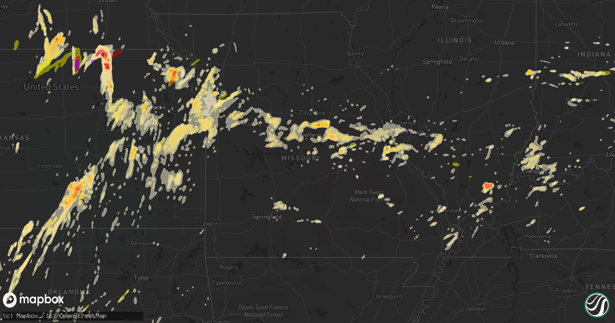
Hail Map in Missouri on April 26, 2016
Get this storm
April 26 map
$229
one time, instant access
Download today. No call, no setup
Keep the $229
Bought the map and want the full workflow? Apply the entire $229 to a subscription within 7 days. None of it is wasted.
Every map, not just this one
This buys you this map. Subscription and you get every map we run, in the markets you choose from a few cities to whole states to nationwide. Plus real-time alerts the moment a storm fires.
Contact data
Name, contact info, occupancy, even credit band for addresses in the footprint. You go from where it hit to who to call.
Become the source they trust
Unlimited branding weather history reports on demand. You already have the documented answer ready for the property owner, and you are the one who showed up with it.
Property data and RoofTrace estimates
Pull up any address you have got, its value and the exact code rules for that jurisdiction, straight from One Click Code. Then RoofTrace estimates the squares, pitch, and roof value, priced the way you price.
Storm reports in Missouri
Missouri
| Date | Description |
|---|---|
| 04/26/20165:23 PM CDT | Numerous shingles torn off the roof at poplar bluff airport |
| 04/26/20164:53 PM CDT | Quarter size hail wnw of duncan |
| 04/26/20164:46 PM CDT | Quarter size hail reported along 38 highway near high praire |
| 04/26/20164:30 PM CDT | Quarter size hail southeast of marshfield |
| 04/26/20164:27 PM CDT | Quarter size hail in marshfield |
| 04/26/20164:20 PM CDT | Quarter size hail 1 mile northwest of marshfield |
| 04/26/20164:06 PM CDT | Quarter size hail farm road 225 north of farm road 22 |
| 04/26/20162:29 PM CDT | Minor damage to two buldings. Rubber roof membrane lifted by winds allowing water into buildings. |
| 04/26/20162:29 PM CDT | A local report indicates 72 MPH wind near 4 NNE ORCHARD FARMS |
| 04/26/20162:19 PM CDT | Multiple limbs down over roadways around 6 inches in diameter. Time estimated from radar. |
| 04/26/20162:17 PM CDT | A local report indicates 60 MPH wind near 1 SSW HAZELWOOD |
| 04/26/20162:10 PM CDT | Several very large trees blown down. One tree was uprooted. |
| 04/26/20162:08 PM CDT | Near intersection of page avenue and lindbergh blvd. |
| 04/26/20162:00 PM CDT | A local report indicates 1.00 inch wind near 2 E EUREKA |
| 04/26/20162:00 PM CDT | Delayed report of ping pong ball size hail in dittmer earlier this aftn |
| 04/26/20161:55 PM CDT | Widespread tree damage. Flag pole and mailbox pole snapped in half. Large tree blown over and numerous large brances blown down. One large branch landed on roof of a ho |
| 04/26/20161:52 PM CDT | A local report indicates 67 MPH wind near 3 W CHESTERFIELD |
| 04/26/20161:49 PM CDT | Hail covering ground. |
| 04/26/20161:40 PM CDT | Large tree uprooted |
| 04/26/20161:40 PM CDT | Tree damage near st. Albans north of highway t. Time approximate. |
| 04/26/20161:35 PM CDT | Several large tree limbs blown down. |
| 04/26/20161:35 PM CDT | Several large tree limbs blown down near intersection of foristell road and highway z. |
| 04/26/20161:30 PM CDT | Numerous trees down |
| 04/26/20161:30 PM CDT | A local report indicates 1.00 inch wind near VILLA RIDGE |
| 04/26/20161:25 PM CDT | Large tree limb down. |
| 04/26/20161:22 PM CDT | Ef0 tornado touched down briefly at the intersection of missouri highways d and t in extreme western st. Charles county. Minor tree and roof damage was observed. |
| 04/26/20161:20 PM CDT | Delayed report of trees down near treloar. Time estimated. |
| 04/26/20161:20 PM CDT | Tree damage near st. Albans north of highway t. Time approximate. |
| 04/26/20161:15 PM CDT | Trees blown over on highway t near highway tt. Some power lines blown down. |
| 04/26/20161:05 PM CDT | On u.s. Highway 50. |
| 04/26/201612:56 PM CDT | A local report indicates 1.00 inch wind near OWENSVILLE |
| 04/26/201612:55 PM CDT | Several trees blown down...between 15 and 25 feet tall. |
| 04/26/201612:45 PM CDT | A local report indicates 1.75 inch wind near BLAND |
| 04/26/201612:44 PM CDT | A local report indicates 60 MPH wind near HERMANN |
| 04/26/201612:35 PM CDT | Several large tree limbs blown down. |
| 04/26/201612:13 PM CDT | Powerlines down... Siding blown off house... Numerous trees down |
| 04/26/201612:00 PM CDT | Telephone lines blown down. |
| 04/26/201611:59 AM CDT | A local report indicates 1.00 inch wind near ELDON |
| 04/26/201611:55 AM CDT | Time estimated by radar |
| 04/26/201611:50 AM CDT | A local report indicates 2.00 inch wind near 2 W GUTHRIE |
| 04/26/201611:47 AM CDT | A local report indicates 1.00 inch wind near FULTON |
| 04/26/201611:44 AM CDT | Dime to quarter sized hail |
| 04/26/201611:40 AM CDT | Trees down |
| 04/26/201611:37 AM CDT | A local report indicates 58 MPH wind near 4 NNE ASHLAND |
| 04/26/201611:35 AM CDT | Some siding damage and tree damage from hail. Most of the hail was around an inch in diameter. |
| 04/26/201611:26 AM CDT | A local report indicates 70 MPH wind near LATHAM |
| 04/26/201611:26 AM CDT | A local report indicates 1.00 inch wind near LATHAM |
| 04/26/201611:22 AM CDT | A local report indicates 70 MPH wind near LATHAM |
| 04/26/201611:13 AM CDT | Several large trees down. |
| 04/26/201611:13 AM CDT | Several large trees down. |
| 04/26/201611:12 AM CDT | Quarter to half dollar sized hail. |
| 04/26/201611:12 AM CDT | Powerlines down along highway 50. |
| 04/26/201610:53 AM CDT | Also 1 inch diameter hail |
| 04/26/201610:52 AM CDT | Severe thunderstorm wind gusts observed by a morgan county sheriffs deputy along highway 50. |
| 04/26/201610:32 AM CDT | Em reported 50-60 mph wind and hail to dime sized |
| 04/26/201610:28 AM CDT | Significant wind damage from the north side of sedalia to near the sedalia airport. A roof was ripped off a business on the north side of sedalia...4 power poles were s |
| 04/26/201610:11 AM CDT | A local report indicates 1.00 inch wind near WHITEMAN AFB |
| 04/26/20169:27 AM CDT | A local report indicates 1.00 inch wind near COLUMBUS |
| 04/26/20169:13 AM CDT | Via twitter |
| 04/26/20169:10 AM CDT | Via twitter |
| 04/26/20169:07 AM CDT | Peas size to quarter size hail... Still coming down. |
| 04/26/20169:04 AM CDT | Power line down at 39th and gudgel |
| 04/26/20169:00 AM CDT | A local report indicates 1.25 inch wind near 3 SE INDEPENDENCE |
| 04/26/20168:47 AM CDT | 50th and todd george rd... Pea to quarter size hail. |
| 04/26/20168:44 AM CDT | Also quarter sized hail with wind |
| 04/26/20168:42 AM CDT | Reported at lake city ammunition plant |
| 04/26/20168:42 AM CDT | Quarter to ping pong size hail... Really flat though. 150 hwy and 291 intersection. |
| 04/26/20168:37 AM CDT | Dock collapse on smithville lake |
| 04/26/20168:22 AM CDT | Penny to quarter size. |
| 04/26/20168:20 AM CDT | A few powerlines down near rushville |
| 04/26/20168:12 AM CDT | A local report indicates 59 MPH wind near ST JOSEPH |
| 04/26/20168:09 AM CDT | Pea to quarter size hail... Very heavy on ground. |
| 04/26/20168:07 AM CDT | A local report indicates 1.25 inch wind near 10 SE PLATTE CITY |
| 04/26/20167:50 AM CDT | A local report indicates 1.00 inch wind near 1 N TRIMBLE |
| 04/26/20167:47 AM CDT | A local report indicates 1.25 inch wind near EDGERTON |
| 04/26/20167:39 AM CDT | Dime to quarter sized hail. |
| 04/26/20167:35 AM CDT | A local report indicates 1.00 inch wind near 5 NE WEATHERBY LAKE |
| 04/26/20167:20 AM CDT | A local report indicates 1.00 inch wind near 3 WNW PARKVILLE |
| 04/26/20163:00 AM CDT | 24 inch diameter oak tree fell on two main lines. Tree was semi-rotten. Near state hwy 14 and hwy vv. Delayed report. |
| 04/26/20162:45 AM CDT | Hail lasted for about 10 minutes with the largest hail stones about an inch. Thunderstorm started around 230am. |
| 04/26/20162:17 AM CDT | Moderate tree limbs down per fire dept at highway 160 and highway 76 |
| 04/26/20162:15 AM CDT | Thunderstorms produced strong straight line winds that tore shingles off of 12 to 15 homes. One home had some decking peeled off. |
| 04/26/20162:07 AM CDT | *** 1 inj *** trees down in hollister downtown and near college of the ozarks. Two homes sustained significant damage from falling trees. Survey crews estimate winds of |
| 04/26/20162:03 AM CDT | A storm survey determined that strong straight line winds uprooted numerous trees and caused minor damage to several homes on point seven peninsula. Some homes had west |
| 04/26/20162:00 AM CDT | Measured 60 mph winds at highway 14 and highway 160 in nixa |
| 04/26/20162:00 AM CDT | Large tree down in downtown branson |
| 04/26/20161:59 AM CDT | Trees down around pointe royale. Survey crews estimate wind speeds are around 65 miles per hour. |
| 04/26/20161:58 AM CDT | A line of thunderstorms producing 70mph straight line winds damaged a home south of kimberling city and produced significant tree damage across joe bald peninsula. Seve |
| 04/26/20161:58 AM CDT | 20ft tree 18 to 24 inch diameter down. Leaf and debris embedded into siding. Corrected direction. |
| 04/26/20161:58 AM CDT | 20ft tree 18 to 24 inch diameter down. Leaf and debris imbedded into siding. |
| 04/26/20161:55 AM CDT | Power poles broken due to wind at ozark mt resort |
| 04/26/20161:55 AM CDT | Numerous sporadic large trees and limbs down on 265 highway south of 376 near skyline road |
| 04/26/20161:55 AM CDT | Small to medium tree limbs down on shore line road |
| 04/26/20161:55 AM CDT | Moderate roof damage to mulitple homes off of shawnee drive and village terrace drive |
| 04/26/20161:54 AM CDT | Minor tree damage with limbs down and windows broken out of a house on royal vista |
| 04/26/20161:54 AM CDT | Large tree over road. Time based on radar. |
| 04/26/20161:49 AM CDT | A national weather service storm survey revealed that an ef-0 tornado damaged a home just outside of the southwest edge of springfield. Damage to the roof...gutters...a |
| 04/26/20161:45 AM CDT | Tree down in republic off p highway |
| 04/26/20161:21 AM CDT | Tree fell into a house |
| 04/26/20161:10 AM CDT | Powerlines and partial tree down in monett |
| 04/26/20161:00 AM CDT | Tree limb down on a vehicle |
| 04/26/201612:48 AM CDT | 67mph wind gust measured at raws site |
| 04/26/201612:45 AM CDT | Several trees snapped or uprooted. Few powerlines downed. |
| 04/26/201612:45 AM CDT | Tree limbs down in carthage |
| 04/26/201612:40 AM CDT | Tree down east of pineville on k highway |
| 04/26/201612:40 AM CDT | Tree down per law enforcement |
| 04/26/201612:40 AM CDT | Trees uprooted in liberal |
| 04/26/201612:40 AM CDT | Powerlines down at i-49 and us 60 in neosho |
| 04/26/201612:38 AM CDT | Strong straight line thunderstorm winds removed shingles off a home and downed several trees. Limbs and roof debris was scattered to the northeast. |
| 04/26/201612:35 AM CDT | Roof blown off house with other houses and debris over the block on gardendale road |
| 04/26/201612:32 AM CDT | Estimated 60 mph winds downed a tree. |
| 04/26/201612:31 AM CDT | A storm survey determined that strong straight line winds produced a damage path nearly a half mile long across part of southern carthage. Several large trees were upro |
| 04/26/201612:26 AM CDT | 64mph wind gust measured on home weather station sw of horton |
| 04/26/201612:25 AM CDT | Quarter size hail reported via storm spotter relayed by em |
| 04/26/201612:25 AM CDT | Estimated 60 mph winds reported via emergency management |
| 04/26/201612:25 AM CDT | Trees and power lines down in lamar. A rv was blown over along interstate 49 |
| 04/26/201612:21 AM CDT | Trees and power lines down |
| 04/26/201612:21 AM CDT | Nws storm survey team confirmed an ef1 tornado approximately two miles north of seneca missouri. The path was approximately one mile with a width of 150 yards. Maximum |
| 04/26/201612:14 AM CDT | Wind damaged a brick structure unknown severity in liberal |
| 04/26/201612:08 AM CDT | Estimated 60 mph winds downed a few trees and damaged a metal building. |
| 04/25/201611:35 PM CDT | Roof blown off house with other houses and debris over the block on gardendale road |
| 04/25/201611:25 PM CDT | Estimated 60 mph winds reported via emergency management |
| 04/25/201611:14 PM CDT | Wind damaged a brick structure unknown severity in liberal |
| 04/25/201610:53 PM CDT | A local report indicates 60 MPH wind near 1 S RAYMORE |
| 04/25/201610:44 PM CDT | Semi overturned at 2 highway and state line...heard on police scanner |
| 04/25/201610:41 PM CDT | A local report indicates 60 MPH wind near 1 S RAYMORE |
All States Impacted by Hail Map on April 26, 2016
Cities Impacted by Hail Map on April 26, 2016
- Williamsburg, MO
- Fulton, MO
- Sabinal, TX
- D Hanis, TX
- Trimble, MO
- Liberty, MO
- Kearney, MO
- Jamestown, KS
- San Saba, TX
- Cherokee, TX
- McGee, MO
- Davidson, OK
- Killeen, TX
- Nowata, OK
- Matfield Green, KS
- Grove City, OH
- Groveport, OH
- Lockbourne, OH
- Columbus, OH
- Paris, IL
- Universal, IN
- Vermilion, IL
- Clinton, IN
- Chanute, KS
- Humboldt, KS
- Erie, KS
- La Harpe, KS
- Iola, KS
- Mount Vernon, IL
- Opdyke, IL
- Boyd, TX
- Hammon, OK
- Leedey, OK
- Assumption, IL
- Saint Elizabeth, MO
- Saint Thomas, MO
- Eugene, MO
- Meta, MO
- Henley, MO
- Winfield, KS
- Dexter, KS
- Burden, KS
- Fort Branch, IN
- Haubstadt, IN
- Leakey, TX
- Rio Frio, TX
- Decatur, TX
- Metropolis, IL
- Brookville, IN
- Madill, OK
- Stewartsville, MO
- Gower, MO
- Tennessee Ridge, TN
- Cumberland City, TN
- Dover, TN
- Rockwall, TX
- Manhattan, KS
- Charleston, IL
- Stanton, TX
- Winters, TX
- Ovalo, TX
- Lawn, TX
- Hollenberg, KS
- Hanover, KS
- Blanchester, OH
- Belleville, KS
- Hubbell, NE
- Narka, KS
- Cuba, KS
- Dill City, OK
- San Angelo, TX
- Christoval, TX
- Claremont, IL
- Olney, IL
- Gainesville, TX
- Burneyville, OK
- Muenster, TX
- Diboll, TX
- Olustee, OK
- Altus, OK
- Eldorado, OK
- Elmer, OK
- Vernon, TX
- Tipton, OK
- Headrick, OK
- Chillicothe, TX
- Odell, TX
- Morgantown, KY
- Caneyville, KY
- Rutland, OH
- Pomeroy, OH
- Cedar Point, KS
- Council Grove, KS
- Americus, KS
- Elmdale, KS
- Emporia, KS
- Strong City, KS
- Cottonwood Falls, KS
- Pacific, MO
- Holden, MO
- Pleasant Hill, MO
- Centerview, MO
- Kingsville, MO
- Rose Hill, KS
- Douglass, KS
- Derby, KS
- Goshen, OH
- Morrow, OH
- Pleasant Plain, OH
- Pennsboro, WV
- Lees Summit, MO
- Valmeyer, IL
- Festus, MO
- Alta Vista, KS
- Bronte, TX
- Marshfield, MO
- Owensboro, KY
- Calhoun, KY
- Bremen, KS
- Richwoods, MO
- Dittmer, MO
- De Soto, MO
- Atchison, KS
- Lancaster, KS
- Washington, KS
- Blue Rapids, KS
- Waterville, KS
- Marysville, KS
- Auburn, KS
- Maple Hill, KS
- Burlingame, KS
- Silver Lake, KS
- Topeka, KS
- Eskridge, KS
- Harveyville, KS
- Formoso, KS
- Webber, KS
- Mankato, KS
- Byron, NE
- Hebron, NE
- Courtland, KS
- Republic, KS
- Ruskin, NE
- Oak, NE
- Deshler, NE
- Jewell, KS
- Davenport, NE
- Hardy, NE
- Fairfield, NE
- Ellinwood, KS
- Great Bend, KS
- Alum Bridge, WV
- Auburn, WV
- Walker, WV
- Coxs Mills, WV
- Pullman, WV
- Harrisville, WV
- Linn, WV
- New Milton, WV
- Cairo, WV
- Berea, WV
- Troy, WV
- Petroleum, WV
- Waverly, WV
- Alva, OK
- Burlington, OK
- Waldron, KS
- Kiowa, KS
- Carmen, OK
- Hazelton, KS
- Dacoma, OK
- Amorita, OK
- Cherokee, OK
- Camden, MO
- Richmond, MO
- Moran, KS
- Cincinnati, OH
- Ft Mitchell, KY
- Hebron, KY
- Erlanger, KY
- Anderson, IN
- Pendleton, IN
- Markleville, IN
- Quenemo, KS
- Melvern, KS
- Williamsburg, KS
- Pomona, KS
- Bloomfield, KY
- Bluff City, KS
- Anthony, KS
- Lawrenceburg, IN
- Llano, TX
- Baird, TX
- Independence, MO
- Buckner, MO
- Yancey, TX
- Bigfoot, TX
- Moore, TX
- Devine, TX
- Charlotte, TX
- Pearsall, TX
- Poteet, TX
- Jourdanton, TX
- Cabool, MO
- Mountain Grove, MO
- Calhoun, IL
- Parkersburg, IL
- Sonora, TX
- Sardinia, OH
- Blanchard, OK
- Holliday, TX
- Elm Creek, NE
- Wichita, KS
- Martinsville, IN
- Greencastle, IN
- Reelsville, IN
- Brazil, IN
- Putnamville, IN
- Cloverdale, IN
- Quincy, IN
- Winnie, TX
- Cleveland, TX
- Willis, TX
- Wichita Falls, TX
- Burnt Prairie, IL
- Golden Gate, IL
- Anson, TX
- Strafford, MO
- Belle, MO
- Joaquin, TX
- Mansfield, LA
- Logansport, LA
- Wright City, MO
- Ottawa, KS
- Wellsville, KS
- Morrowville, KS
- Francisco, IN
- Garden City, TX
- Midland, TX
- Lampasas, TX
- Kempner, TX
- Golconda, IL
- Harvard, NE
- Glenvil, NE
- Nelson, NE
- Deweese, NE
- Edgar, NE
- Clay Center, NE
- Bloomington, IN
- Olpe, KS
- Madison, KS
- Hartford, KS
- Alma, KS
- Wamego, KS
- Shawnee, KS
- Kansas City, KS
- Bonner Springs, KS
- Ballwin, MO
- Kingfisher, OK
- Okarche, OK
- Cashion, OK
- Breese, IL
- Okawville, IL
- Mascoutah, IL
- Marissa, IL
- Germantown, IL
- Aviston, IL
- Lenzburg, IL
- Trenton, IL
- New Baden, IL
- Bartelso, IL
- Saint Libory, IL
- Albers, IL
- Addieville, IL
- Freeburg, IL
- Jamestown, OH
- Xenia, OH
- Fairview, OK
- Walton, WV
- Mason, TX
- Wingate, TX
- Washington Court House, OH
- Jeffersonville, OH
- Oran, MO
- Bell City, MO
- Moline, KS
- Elk Falls, KS
- Holdrege, NE
- Arlington, IN
- Rushville, IN
- Cleveland, MO
- Bucyrus, KS
- Louisburg, KS
- Belton, MO
- Stilwell, KS
- Kansas City, MO
- Raymore, MO
- Peculiar, MO
- Overland Park, KS
- Voss, TX
- Ballinger, TX
- Hermleigh, TX
- Robards, KY
- El Reno, OK
- De Witt, NE
- Plymouth, NE
- Blue Hill, NE
- Lawrence, NE
- Rueter, MO
- Protem, MO
- Lexington, IN
- Scottsburg, IN
- Butler, OK
- Canute, OK
- Clinton, OK
- Caulfield, MO
- Clarksville, OH
- Wilmington, OH
- Wellington, KS
- Mayfield, KS
- Graham, MO
- Calumet, OK
- Sterling City, TX
- Harrisonville, MO
- Coalgate, OK
- Atoka, OK
- Bland, MO
- Merkel, TX
- Del Rio, TX
- Snyder, TX
- Evant, TX
- Blackwell, MO
- Quanah, TX
- Dixon, KY
- Enid, OK
- Drummond, OK
- Waukomis, OK
- Denton, KS
- Cummings, KS
- Effingham, KS
- Bendena, KS
- Everest, KS
- Mokane, MO
- Ira, TX
- Rotan, TX
- Sweetwater, TX
- Palestine, TX
- Tennessee Colony, TX
- Montalba, TX
- Castor, LA
- Bienville, LA
- Coushatta, LA
- Ashland, LA
- Republican City, NE
- Naponee, NE
- Sedalia, MO
- Smithton, MO
- Stover, MO
- Versailles, MO
- Lincoln, MO
- Cole Camp, MO
- Mora, MO
- Hartville, MO
- Saint James, MO
- Rolla, MO
- Labadie, MO
- Washington, MO
- Villa Ridge, MO
- Fair Grove, MO
- Flat Rock, IN
- Saint Paul, IN
- Greensburg, IN
- Horton, KS
- Powhattan, KS
- Kingston, OK
- Mulvane, KS
- Belle Plaine, KS
- Cedar Hill, MO
- Weinert, TX
- Hamlin, TX
- Rule, TX
- Knox City, TX
- O'Brien, TX
- Haskell, TX
- Rochester, TX
- Aspermont, TX
- Stamford, TX
- Mena, AR
- Bidwell, OH
- Paden, OK
- Crawfordsville, IN
- Eldorado, TX
- Pilot Point, TX
- Collinsville, TX
- Valley View, TX
- Tioga, TX
- Grandview, MO
- Hunter, OK
- Lamont, OK
- Garber, OK
- Yellow Springs, OH
- Fairborn, OH
- Wynnewood, OK
- Davis, OK
- Chesterfield, MO
- Saint Louis, MO
- Middletown, OH
- Converse, LA
- Zavalla, TX
- Broaddus, TX
- Pineland, TX
- Hemphill, TX
- Wiergate, TX
- Brookeland, TX
- Bronson, TX
- Ozona, TX
- Waverly, OH
- Beaver, OH
- Elkland, MO
- Niangua, MO
- Conway, MO
- Saronville, NE
- Sutton, NE
- Steelville, MO
- Salem, MO
- Wesco, MO
- Rocksprings, TX
- Russellville, MO
- California, MO
- Junction, IL
- Equality, IL
- Marlow, OK
- Duncan, OK
- Bethel, OH
- Silsbee, TX
- Excelsior Springs, MO
- Tebbetts, MO
- Junction, TX
- London, TX
- Crowell, TX
- Wadesville, IN
- Mount Vernon, IN
- Caldwell, KS
- South Haven, KS
- Clay, WV
- Summersville, WV
- Eldorado, IL
- Carrier Mills, IL
- Harrisburg, IL
- Sullivan, IL
- Henrietta, TX
- Funk, NE
- Millersview, TX
- Rosston, TX
- Lindsay, TX
- Era, TX
- Waltonville, IL
- Fairview, KS
- Sabetha, KS
- Morrill, KS
- Hiawatha, KS
- Boonville, IN
- Richland, IN
- Tennyson, IN
- Chrisney, IN
- Kemp, TX
- Kaufman, TX
- Mabank, TX
- Hartsburg, MO
- New Bloomfield, MO
- Ashland, MO
- Comanche, TX
- De Leon, TX
- Dublin, TX
- Plattsburg, MO
- Eureka, MO
- High Ridge, MO
- House Springs, MO
- Little Elm, TX
- Centralia, IL
- West Union, WV
- Chester, TX
- Princeton, IN
- Patoka, IN
- Cedar Vale, KS
- Louisville, KY
- Sims, IL
- Geff, IL
- Fairfield, IL
- Lone Wolf, OK
- Carter, OK
- Sentinel, OK
- Granite, OK
- Herod, IL
- Eddyville, IL
- Grantsburg, IL
- Simpson, IL
- Truxton, MO
- Bellflower, MO
- Batavia, OH
- Milford, OH
- Tecumseh, KS
- Williamsport, OH
- Circleville, OH
- Drexel, MO
- Spring Hill, KS
- Archie, MO
- Olathe, KS
- Freeman, MO
- Neosho Rapids, KS
- Hamilton, KS
- Lebo, KS
- Eureka, KS
- Centerville, KS
- Agency, MO
- Purcell, OK
- Oklahoma City, OK
- Lindsay, OK
- Washington, OK
- Norman, OK
- Monrovia, IN
- Burns, KS
- Greenwood, IN
- Olsburg, KS
- Carleton, NE
- Falls City, TX
- Campbellton, TX
- Pleasanton, TX
- Crawford, OK
- Roscoe, TX
- Maryneal, TX
- Abilene, TX
- Colorado City, TX
- Breckenridge, TX
- Westbrook, TX
- Dyess Afb, TX
- Robert Lee, TX
- Blackwell, TX
- Nolan, TX
- Tuscola, TX
- Albany, TX
- Clyde, TX
- Tye, TX
- Moran, TX
- Loraine, TX
- Wahoo, NE
- Ithaca, NE
- Nash, OK
- Leon, WV
- Rossville, KS
- Delia, KS
- Troy, IN
- Evanston, IN
- Oakwood, OK
- Seiling, OK
- Floresville, TX
- Mooreland, OK
- Burnet, TX
- Kingsland, TX
- Buchanan Dam, TX
- Blue Springs, MO
- Otway, OH
- Peebles, OH
- Latham, OH
- Piketon, OH
- Hillsboro, OH
- Rarden, OH
- Clyde, KS
- Agenda, KS
- Edgerton, KS
- De Kalb, MO
- Superior, NE
- Buna, TX
- Vidor, TX
- Spencer, IN
- Solsberry, IN
- Charleston, MO
- New Madrid, MO
- East Prairie, MO
- Osgood, IN
- Batesville, IN
- New Athens, IL
- Summerfield, IL
- Lebanon, IL
- Greenwich, KS
- Kechi, KS
- Peck, KS
- Potwin, KS
- Conway Springs, KS
- Viola, KS
- Valley Center, KS
- Wakita, OK
- Benton, KS
- Milan, KS
- Whitewater, KS
- Argonia, KS
- Towanda, KS
- Medford, OK
- Manchester, OK
- Augusta, KS
- Goddard, KS
- Clearwater, KS
- Andover, KS
- Colwich, KS
- Maize, KS
- Haysville, KS
- Vichy, MO
- Burlington, KS
- Waverly, KS
- Ashley, IL
- Nashville, IL
- Mineral Wells, TX
- Lumberton, TX
- Wolfe City, TX
- New Lexington, OH
- Crooksville, OH
- Somerset, OH
- Corning, OH
- Roseville, OH
- Reydon, OK
- Gainesville, MO
- Odessa, MO
- Lexington, MO
- Mayview, MO
- Evansville, IN
- Houstonia, MO
- Hughesville, MO
- Miamiville, OH
- Loveland, OH
- Camp Dennison, OH
- Mullin, TX
- Goldthwaite, TX
- Borden, IN
- Greenville, IN
- Floyds Knobs, IN
- Annapolis, MO
- Pittsfield, IL
- Loving, TX
- Olney, TX
- Graham, TX
- Rogersville, MO
- Belvidere, NE
- Bruning, NE
- Chamois, MO
- Hermann, MO
- Morrison, MO
- Rockville, IN
- Montezuma, IN
- Cross Plains, TX
- Menard, TX
- Melvin, TX
- Piedmont, KS
- Grenola, KS
- Henderson, KY
- Mountain Park, OK
- Indiahoma, OK
- Snyder, OK
- Lawton, OK
- Roosevelt, OK
- Virgil, KS
- Junction City, KS
- Dwight, KS
- Eldon, MO
- Lawrence, KS
- Sedan, KS
- Peru, KS
- Harper, TX
- Doss, TX
- Oak Hill, OH
- Justin, TX
- Ponder, TX
- Arkansas City, KS
- Poolville, TX
- Bridgeport, TX
- Santa Anna, TX
- Coleman, TX
- Stilesville, IN
- Coatesville, IN
- Fillmore, IN
- Benjamin, TX
- Munday, TX
- Seymour, TX
- Aubrey, TX
- Denton, TX
- Syracuse, OH
- Sandyville, WV
- Le Roy, WV
- Racine, OH
- West Columbia, WV
- Portland, OH
- Langsville, OH
- Middleport, OH
- Mason, WV
- Hartford, WV
- Ravenswood, WV
- Leesburg, OH
- Waterloo, IL
- Garnett, KS
- Nevada, TX
- Royse City, TX
- Novice, TX
- Talpa, TX
- Glenwood, IN
- Rising Star, TX
- Cisco, TX
- Bunceton, MO
- Uvalde, TX
- McClure, IL
- Cape Girardeau, MO
- Utica, KY
- Wilber, NE
- Lyndon, KS
- Overbrook, KS
- Vassar, KS
- Georgetown, OH
- Bellevue, KY
- Latonia, KY
- Covington, KY
- Amelia, OH
- Fort Thomas, KY
- Melbourne, KY
- Newport, KY
- New Richmond, OH
- Mount Orab, OH
- Dayton, KY
- Williamsburg, OH
- Hamersville, OH
- Winchester, OH
- Silver Grove, KY
- Alexandria, KY
- Seaman, OH
- Midland, OH
- Delaware, OK
- Leslie, MO
- Gerald, MO
- Eastland, TX
- Carbon, TX
- Jamestown, MO
- New Vienna, OH
- Richland Springs, TX
- Rochelle, TX
- Charlottesville, IN
- Wills Point, TX
- Walters, OK
- Randall, KS
- Scandia, KS
- Straughn, IN
- New Castle, IN
- Columbia, MO
- Inland, NE
- Trumbull, NE
- Galloway, OH
- Norborne, MO
- Sweetwater, OK
- Randolph, KS
- East Alton, IL
- Perrin, TX
- Graford, TX
- Chandler, IN
- Gandeeville, WV
- Linn, MO
- Tuscumbia, MO
- Fort Cobb, OK
- Carnegie, OK
- Crofton, KY
- Dawson Springs, KY
- Mcconnelsville, OH
- Stockport, OH
- Blue Rock, OH
- Malta, OH
- Glenford, OH
- Mount Perry, OH
- Thornville, OH
- Millersport, OH
- Pleasantville, OH
- Owensville, MO
- Dudley, MO
- Byars, OK
- Stratford, OK
- Ada, OK
- Eufaula, OK
- Mansfield, MO
- Macomb, MO
- Willisburg, KY
- Harrodsburg, KY
- Lawrenceburg, KY
- Wallback, WV
- Maysel, WV
- Athens, TX
- Waynoka, OK
- Du Quoin, IL
- Vergennes, IL
- Gray Summit, MO
- Holton, IN
- Butlerville, IN
- Knightstown, IN
- Carthage, IN
- Greenfield, IN
- Wilkinson, IN
- West Paducah, KY
- Latham, MO
- Fortuna, MO
- Tipton, MO
- Tilden, TX
- Calliham, TX
- Beatrice, NE
- Gustine, TX
- Ferdinand, IN
- Corrigan, TX
- Livingston, TX
- Liberty, NE
- Burchard, NE
- Walkersville, WV
- Orlando, WV
- Weston, WV
- Shelbyville, IN
- Fountaintown, IN
- Morristown, IN
- Fairland, IN
- New Palestine, IN
- Jefferson City, MO
- Reading, KS
- Amanda, OH
- Lancaster, OH
- Rockbridge, OH
- Laurelville, OH
- Sidney, TX
- Deer, AR
- Canton, TX
- Griggsville, IL
- Terre Haute, IN
- Helena, OK
- Cleo Springs, OK
- Aline, OK
- Chandler, OK
- Agra, OK
- Hepler, KS
- Beaumont, TX
- Longdale, OK
- South Charleston, OH
- South Solon, OH
- Cedarville, OH
- Hillsboro, MO
- Ringgold, TX
- Nocona, TX
- Poland, IN
- Bowling Green, IN
- Lynnville, IN
- Rockport, IN
- Owensville, IN
- Decker, IN
- Hazleton, IN
- Oakland City, IN
- Elberfeld, IN
- Newburgh, IN
- Petersburg, IN
- Cynthiana, IN
- Poseyville, IN
- Gentryville, IN
- Vincennes, IN
- New Harmony, IN
- Reed, KY
- Benedict, KS
- Buffalo, KS
- Fredonia, KS
- Yates Center, KS
- Clarksburg, MO
- Leon, KS
- Atlanta, KS
- Amherst, NE
- Rock, KS
- Custer City, OK
- Natalia, TX
- Hondo, TX
- Niotaze, KS
- Vienna, MO
- Moberly, MO
- Gardner, KS
- Underwood, IN
- Bonnots Mill, MO
- Jonesville, KY
- Dry Ridge, KY
- Glencoe, KY
- Noble, IL
- Barnes, KS
- Leonardville, KS
- Odell, NE
- Linn, KS
- Wymore, NE
- Riley, KS
- Diller, NE
- Taloga, OK
- Lenexa, KS
- Lynchburg, OH
- Martinsville, OH
- Rantoul, KS
- Princeton, KS
- Emory, TX
- Hamilton, TX
- Oak Grove, MO
- Grain Valley, MO
- Brownwood, TX
- Leawood, KS
- Riverside, MO
- Groveton, TX
- Elk City, KS
- Chester, OK
- Greeley, KS
- Edmond, OK
- Quinlan, TX
- Bertrand, MO
- Bristow, OK
- Kellyville, OK
- Hennessey, OK
- Lucasville, OH
- McDermott, OH
- Windsor, IL
- Gays, IL
- Hennepin, OK
- Elmore City, OK
- Franklin, OH
- Osage City, KS
- Carbondale, KS
- Scranton, KS
- Allen, KS
- Admire, KS
- La Grange, KY
- Smithfield, KY
- Kountze, TX
- Pembroke, KY
- Edgewood, TX
- Lincolnville, KS
- Marion, KS
- Ramona, KS
- Copperas Cove, TX
- Enon, OH
- Springfield, OH
- Dayton, OH
- New Carlisle, OH
- Medway, OH
- West Chester, OH
- Hamilton, OH
- Rosebud, MO
- Carrier, OK
- Goltry, OK
- Elsmore, KS
- Savonburg, KS
- Eden, TX
- Vancourt, TX
- Fort Scott, KS
- Alma, NE
- Orleans, NE
- Pauls Valley, OK
- Paoli, OK
- Stroud, OK
- Greenwood, MO
- Foss, OK
- Liberty, IN
- Newton, KS
- North Bend, OH
- Woodville, TX
- Sharon, OK
- Gatesville, TX
- Jonesboro, TX
- Brackettville, TX
- Mount Sterling, MO
- El Dorado, KS
- Gorman, TX
- Belton, TX
- Cedar Grove, IN
- Castell, TX
- Fredericksburg, TX
- Grand Saline, TX
- Purmela, TX
- Branchville, IN
- Smithland, KY
- Manitou, KY
- Hanson, KY
- Madisonville, KY
- Jacksboro, TX
- Pawnee, OK
- Glencoe, OK
- Saint Peters, MO
- Saint Charles, MO
- Marland, OK
- Ralston, OK
- Sedgwick, KS
- Bowie, TX
- Toronto, KS
- Basehor, KS
- Waldron, MO
- Prairie Village, KS
- Holt, MO
- Smithville, MO
- Mission, KS
- Platte City, MO
- Edgerton, MO
- Tonganoxie, KS
- Chaffee, MO
- Advance, MO
- Scott Air Force Base, IL
- Bardwell, KY
- Rosedale, IN
- Carbon, IN
- Bridgeton, IN
- Lathrop, MO
- Irvine, KY
- Forestburg, TX
- Alvord, TX
- Parkersburg, WV
- Dearborn, MO
- Faucett, MO
- King City, MO
- Amity, MO
- Maysville, MO
- Sunman, IN
- Paola, KS
- Barksdale, TX
- Eaton, OH
- Connersville, IN
- Camden, OH
- Brownsville, IN
- College Corner, OH
- Sharpsburg, KY
- Owingsville, KY
- Comstock, TX
- Vienna, WV
- Fleming, OH
- Belpre, OH
- Marietta, OH
- Laurel, IN
- Neosho Falls, KS
- Linwood, KS
- Osborn, MO
- Osawatomie, KS
- Adrian, MO
- New Century, KS
- Orrick, MO
- Henrietta, MO
- Westphalia, KS
- Butler, MO
- Bates City, MO
- Turney, MO
- Napoleon, MO
- Hardin, MO
- Cameron, MO
- Sibley, MO
- Welda, KS
- Colony, KS
- De Soto, KS
- Le Roy, KS
- Amsterdam, MO
- La Cygne, KS
- Richmond, KS
- Wellington, MO
- Baldwin City, KS
- Altoona, KS
- Lesterville, MO
- Warrenton, MO
- Foster, OK
- Crete, NE
- Martell, NE
- Clatonia, NE
- Hallam, NE
- Arnett, OK
- Sharon Grove, KY
- McFarland, KS
- Saint George, KS
- Paxico, KS
- Clifton, KS
- Oketo, KS
- Haddam, KS
- Knob Noster, MO
- Moro, AR
- Rhineland, MO
- Portland, MO
- Montgomery City, MO
- Rowena, TX
- Oldenburg, IN
- Saint Albans, MO
- Defiance, MO
- Augusta, MO
- Wildwood, MO
- Cache, OK
- Bertrand, NE
- Oxford, NE
- Atlanta, NE
- Pelican, LA
- Pleasant Hill, LA
- Troy, KS
- Muscotah, KS
- Rushville, MO
- Nortonville, KS
- Whiting, KS
- Reedsville, OH
- Paragon, IN
- Gosport, IN
- Ripley, WV
- Given, WV
- Udall, KS
- Calico Rock, AR
- Otisco, IN
- Marysville, IN
- Saint Paul, KS
- Asher, OK
- Waldron, IN
- Alhambra, IL
- Marine, IL
- Weatherford, TX
- Berryton, KS
- Morganfield, KY
- Vienna, IL
- Letart, WV
- Guide Rock, NE
- Woodward, OK
- Falls City, NE
- Weston, MO
- Winchester, KS
- Saint Joseph, MO
- Easton, KS
- Sullivan, MO
- Jasper, TX
- Colmesneil, TX
- Hillister, TX
- Choctaw, OK
- Arcadia, OK
- Spencer, OK
- Luther, OK
- Jones, OK
- Procious, WV
- Amma, WV
- Rosalia, KS
- Barnard, KS
- Camp, AR
- Warrensburg, MO
- Berger, MO
- McLouth, KS
- Oakwood, TX
- Throckmorton, TX
- Terrell, TX
- Crawford, TX
- Lebanon, OH
- Freeburg, MO
- Frederick, OK
- Gracemont, OK
- Mountain View, OK
- Frankfort, KY
- Winchester, IL
- San Antonio, TX
- Vallonia, IN
- Brownstown, IN
- Harrah, OK
- Sheridan, IN
- Williamstown, WV
- Glenville, WV
- Burnsville, WV
- Cutler, OH
- Stewart, OH
- Vincent, OH
- Millfield, OH
- Athens, OH
- Amesville, OH
- Dahlgren, IL
- Metamora, IN
- Canadian, TX
- Durham, OK
- Rhome, TX
- Meno, OK
- Ranger, TX
- Sumner, IL
- Chester, NE
- Sour Lake, TX
- China, TX
- Elkton, KY
- Barnhart, MO
- Herculaneum, MO
- Pevely, MO
- Horseshoe Bend, AR
- Highland, KS
- White Cloud, KS
- Ringwood, OK
- Cheshire, OH
- May, TX
- Berry, KY
- Cynthiana, KY
- Noble, OK
- Lexington, OK
- Krum, TX
- Higginsville, MO
- Aurora, NE
- Giltner, NE
- Phillips, NE
- Mount Sterling, OH
- Lone Jack, MO
- Mount Judea, AR
- Mapleton, KS
- Bronson, KS
- Uniontown, KS
- Georgetown, KY
- Midway, KY
- Hendrix, OK
- Denison, TX
- Anadarko, OK
- Ellenboro, WV
- Arnold, NE
- Southside, WV
- Milroy, IN
- Stonefort, IL
- Chico, TX
- Rocky Mount, MO
- Barnett, MO
- Art, TX
- Salt Lick, KY
- Morehead, KY
- Stewart, TN
- Springtown, TX
- Walnut, KS
- North Vernon, IN
- Westport, IN
- Stilwell, OK
- Liberty, TX
- Sanger, TX
- Fort Riley, KS
- Imperial, MO
- Columbia, IL
- Streetman, TX
- Richland, TX
- Reedy, WV
- Palestine, WV
- Paducah, KY
- Cunningham, KY
- Gordon, TX
- South Lebanon, OH
- Fayetteville, OH
- Maineville, OH
- Mutual, OK
- Hillsdale, IN
- Marthasville, MO
- Union, MO
- New Haven, MO
- Foristell, MO
- Coxs Creek, KY
- Lometa, TX
- Gouldbusk, TX
- Valera, TX
- Old Glory, TX
- Sylvester, TX
- McFall, MO
- Pattonsburg, MO
- Waterford, OH
- Elk City, OK
- Luebbering, MO
- Grubville, MO
- Robertsville, MO
- Arnold, MO
- Catawissa, MO
- Lonedell, MO
- Burkett, TX
- Cutler, IL
- Milton, KS
- Troy, IL
- Lavon, TX
- Rockwood, IL
- Otterville, MO
- Florence, MO
- Sweet Springs, MO
- Pilot Grove, MO
- Concordia, MO
- Garden City, MO
- Corder, MO
- La Monte, MO
- Nelson, MO
- Ionia, MO
- Huntsville, TX
- Mayetta, KS
- Fults, IL
- Crystal City, MO
- Orange, TX
- Norwood, MO
- Beaufort, MO
- Freeport, KS
- Mcconnell Afb, KS
- Thomas, OK
- Jet, OK
- Danville, KS
- Oxford, KS
- Okeene, OK
- Isabella, OK
- Ames, OK
- Lahoma, OK
- Bicknell, IN
- Ragsdale, IN
- Wheatland, IN
- Marble Hill, MO
- Marietta, OK
- Thackerville, OK
- Hodgen, OK
- Alpha, OH
- Moscow, TX
- Seguin, TX
- Byers, TX
- Wakarusa, KS
- Millsap, TX
- Fort Worth, TX
- Florissant, MO
- West Alton, MO
- Hanover, IN
- Madison, IN
- Lohn, TX
- Nardin, OK
- Braman, OK
- Lockport, KY
- Fletcher, MO
- Noblesville, IN
- Beloit, KS
- Bertram, TX
- Wellsville, MO
- Bainbridge, OH
- Marshall, IL
- Owenton, KY
- Newcastle, TX
- Bourbon, MO
- Goshen, KY
- Westport, KY
- Wayne, OK
- Maysville, OK
- Checotah, OK
- Bloomingburg, OH
- Saint Jacob, IL
- Redfield, KS
- Clarksdale, MO
- McCune, KS
- Girard, KS
- Hillsboro, KY
- Valley Falls, KS
- Wetmore, KS
- Robinson, KS
- Tuttle, OK
- Minco, OK
- Grandview, IN
- Newalla, OK
- Mcloud, OK
- Lohman, MO
- Westphalia, MO
- Valley Park, MO
- Maryland Heights, MO
- Bridgeton, MO
- Centertown, MO
- Holts Summit, MO
- Loose Creek, MO
- O'Fallon, MO
- Electra, TX
- Chickasha, OK
- Simpsonville, KY
- Seymour, IN
- Gage, OK
- Fargo, OK
- Bangs, TX
- Florence, TX
- Briggs, TX
- Kiefer, OK
- Mounds, OK
- Glenpool, OK
- Gridley, KS
- Utopia, TX
- Alma, AR
- Pleasureville, KY
- Tahlequah, OK
- Springfield, MO
- Bellevue, TX
- Bluffs, IL
- Meredosia, IL
- Spencer, WV
- Whitesboro, TX
- Boonville, MO
- Eudora, KS
- Meeker, OK
- Middletown, MO
- Groves, TX
- Port Arthur, TX
- Shade, OH
- Cuba, MO
- Dongola, IL
- Iberia, MO
- Ulman, MO
- Sparta, KY
- Red Bud, IL
- Zanesville, OH
- Vinton, OH
- West Jefferson, OH
- East Saint Louis, IL
- Venice, IL
- Lovejoy, IL
- Oakdale, IL
- Sunset, TX
- Montague, TX
- Cushing, OK
- Norris City, IL
- Broughton, IL
- Hope, IN
- Shawneetown, IL
- Mattoon, IL
- Dover, MO
- Saint Clair, MO
- Saint Croix, IN
- Derby, IN
- Tell City, IN
- Clayton, IN
- Mooresville, IN
- Camby, IN
- Bargersville, IN
- Telephone, TX
- Brady, TX
- Corn, OK
- Marshall, OK
- Burr Oak, KS
- West Terre Haute, IN
- Zalma, MO
- Ceresco, NE
- London, OH
- West Union, OH
- Mount Erie, IL
- Hawley, TX
- Newkirk, OK
- Heavener, OK
- Matthews, MO
- Roby, TX
- Bloomfield, IN
- Versailles, KY
- Nashville, IN
- Jackson, MO
- Circleville, KS
- Soldier, KS
- Wayne City, IL
- Wathena, KS
- Waterloo, OH
- Pedro, OH
- Lane, KS
- Fontana, KS
- Parker, KS
- Morrison, OK
- Brookesmith, TX
- Jameson, MO
- Coffey, MO
- Gallatin, MO
- Meridian, OK
- Coyle, OK
- Guthrie, OK
- Waveland, IN
- Mountain View, AR
- Ennis, TX
- Scottown, OH
- Willow Wood, OH
- Chillicothe, OH
- Bluford, IL
- Haven, KS
- Fairview Heights, IL
- O'Fallon, IL
- Catlettsburg, KY
- Kenova, WV
- Huntington, WV
- Atlanta, IN
- Fowlerton, TX
- Bruceville, IN
- Union City, OK
- Lawson, MO
- Leavenworth, KS
- Hico, TX
- New Franklin, MO
- Franklin, MO
- Pontotoc, TX
- Carlinville, IL
- Gillespie, IL
- Longton, KS
- Clendenin, WV
- Raymond, NE
- Spottsville, KY
- Petrolia, TX
- Windthorst, TX
- Bokchito, OK
- Cheyenne, OK
- Ryan, OK
- Lodi, MO
- Silva, MO
- Kevil, KY
- Melber, KY
- Bloomsdale, MO
- Manilla, IN
- Homer, IN
- Ashland, KY
- Barnsdall, OK
- Skiatook, OK
- Mason, OH
- Saint Marys, WV
- Claflin, KS
- Ponca City, OK
- Grand Chain, IL
- Ullin, IL
- Karnak, IL
- Marlin, TX
- Odon, IN
- New Holland, OH
- Pond Creek, OK
- Briscoe, TX
- Goldsboro, TX
- Norton, TX
- Oklaunion, TX
- Couch, MO
- Pocahontas, AR
- Myrtle, MO
- Hoisington, KS
- Mount Alto, WV
- Trenton, KY
- Hopewell, OH
- Heath, OH
- Clearfield, KY
- Fairfield, TX
- Teague, TX
- Stoutsville, OH
- Lyford, TX
- Sebastian, TX
- San Perlita, TX
- Pollok, TX
- Wilson, OK
- Overbrook, OK
- Addyston, OH
- Independence, KY
- Terrace Park, OH
- Petersburg, KY
- Aurora, IN
- Clay, KY
- Reno, OH
- Newport, OH
- New Matamoras, OH
- Philpot, KY
- Quapaw, OK
- Miami, OK
- Galatia, IL
- Plainfield, IN
- Whiteland, IN
- Peabody, KS
- Shepherd, TX
- Lexington, KY
- Crothersville, IN
- Austin, IN
- Pulaski, IL
- Villa Ridge, IL
- Olmsted, IL
- Spring Valley, OH
- Waynesville, OH
- Princeton, KY
- Saint Charles, KY
- Nortonville, KY
- Cerulean, KY
- Cement, OK
- Strawn, TX
- Perkins, OK
- Stillwater, OK
- Bloomfield, MO
- Salvisa, KY
- Syracuse, MO
- Fayetteville, AR
- West Fork, AR
- Hoyt, KS
- Carlyle, IL
- La Vernia, TX
- Saint Hedwig, TX
- Stockdale, TX
- Stark, KS
- Camp Wood, TX
- Sebree, KY
- Campbellsburg, KY
- Bedford, KY
- Shelbyville, KY
- Argyle, TX
- Du Bois, IL
- Tamaroa, IL
- Sapulpa, OK
- Stephenville, TX
- Elkins, AR
- Big Spring, TX
- Marshall, AR
- Walnut Hill, IL
- Oconee, IL
- Avoca, TX
- Lapel, IN
- Blue Mound, KS
- Piedmont, OK
- Sherman, TX
- Mustang, OK
- Whiteman Air Force Base, MO
- Bickmore, WV
- Camden Point, MO
- Jeffersonville, IN
- Higbee, MO
- Silex, MO
- Hawk Point, MO
- Doole, TX
- Green Ridge, MO
- Windsor, MO
- Gunter, TX
- Howe, TX
- Galesburg, KS
- Thayer, KS
- McLeansboro, IL
- Indianapolis, IN
- Dille, WV
- Scotland, TX
- Early, TX
- Leonard, TX
- Blue Ridge, TX
- Trenton, TX
- New Liberty, KY
- Crown City, OH
- Holton, KS
- Guilford, IN
- Centerpoint, IN
- Cory, IN
- Ripley, OK
- Evans, WV
- Wilkesville, OH
- Long Bottom, OH
- Albany, OH
- Millwood, WV
- Cottageville, WV
- Hoyleton, IL
- Dixon, MO
- Martinsburg, MO
- Pickerington, OH
- Canal Winchester, OH
- Jonesburg, MO
- High Hill, MO
- Lead Hill, AR
- Cedarcreek, MO
- Wilberforce, OH
- Whitewater, MO
- Amazonia, MO
- Mammoth Spring, AR
- Bradley, OK
- Alex, OK
- Rush Springs, OK
- Alba, TX
- La Center, KY
- Okmulgee, OK
- Beggs, OK
- Caddo, TX
- Desdemona, TX
- Foster, MO
- Carrollton, MO
- Cassoday, KS
- Chariton, IA
- Coahoma, TX
- Corsicana, TX
- Buffalo, MO
- Half Way, MO
- Point Pleasant, WV
- Alum Creek, WV
- Sod, WV
- Sumerco, WV
- Mineral Point, MO
- Watonga, OK
- Latham, KS
- Yukon, OK
- Saint Jo, TX
- Montreal, MO
- Brumley, MO
- Terral, OK
- Denison, KS
- Centralia, MO
- Thompson, MO
- Blair, OK
- Mangum, OK
- Hulbert, OK
- Fort Gibson, OK
- Murphysboro, IL
- Elkville, IL
- Lewisport, KY
- Bagdad, KY
- Moorefield, KY
- Hopkinsville, KY
- Independence, KS
- Paris, KY
- Hartford, KY
- Clark, MO
- Grand Cane, LA
- Apache, OK
- Cyril, OK
- Hollister, OK
- Wellston, OK
- Maryville, MO
- Madison, MO
- Belvue, KS
- Macedonia, IL
- Corinth, KY
- Vandalia, IL
- Keyesport, IL
- Erin, TN
- Highland, IL
- Pocahontas, IL
- Pekin, IN
- Salem, IN
- Sulphur Springs, AR
- Gravette, AR
- Vanderpool, TX
- Allentown, NJ
- Trenton, NJ
- Robbinsville, NJ
- Looneyville, WV
- Left Hand, WV
- Mcalester, OK
- Proctor, OK
- Mounds, IL
- West Salem, IL
- Marshall, IN
- Wilsey, KS
- Ogden, KS
- White City, KS
- Palmer, KS
- Hinton, OK
- Charlestown, IN
- Shidler, OK
- Elizabethtown, IL
- Bristow, IN
- Kincaid, KS
- Santo, TX
- Dexter, MO
- Spurger, TX
- Warren, TX
- Nineveh, IN
- Piqua, KS
- Depew, OK
- Pinckneyville, IL
- Whitestown, IN
- Chapman, KS
- Rulo, NE
- McCaulley, TX
- Caddo Mills, TX
- Greenfield, OH
- Stamping Ground, KY
- Puxico, MO
- Gay, WV
- Kenna, WV
- Proctorville, OH
- Norway, KS
- Glen Elder, KS
- Munden, KS
- Reynolds, NE
- Fairbury, NE
- Mahaska, KS
- Red Cloud, NE
- Inavale, NE
- Lebanon, KS
- Morganville, KS
- Goff, KS
- Centralia, KS
- Corning, KS
- Seneca, KS
- Loomis, NE
- Kearney, NE
- Shawnee, OK
- West Frankfort, IL
- Wray, CO
- Yuma, CO
- Eckley, CO
- Holyoke, CO
- Imperial, NE
- Champion, NE
- Elbing, KS
- Deer Creek, OK
- Seymour, MO
- Anderson, MO
- Home, KS
- Beattie, KS
- Summerfield, KS
- Blackburn, MO
- Alma, MO
- Elwood, KS
- Cosby, MO
- Boggstown, IN
- Franklin, IN
- Needham, IN


