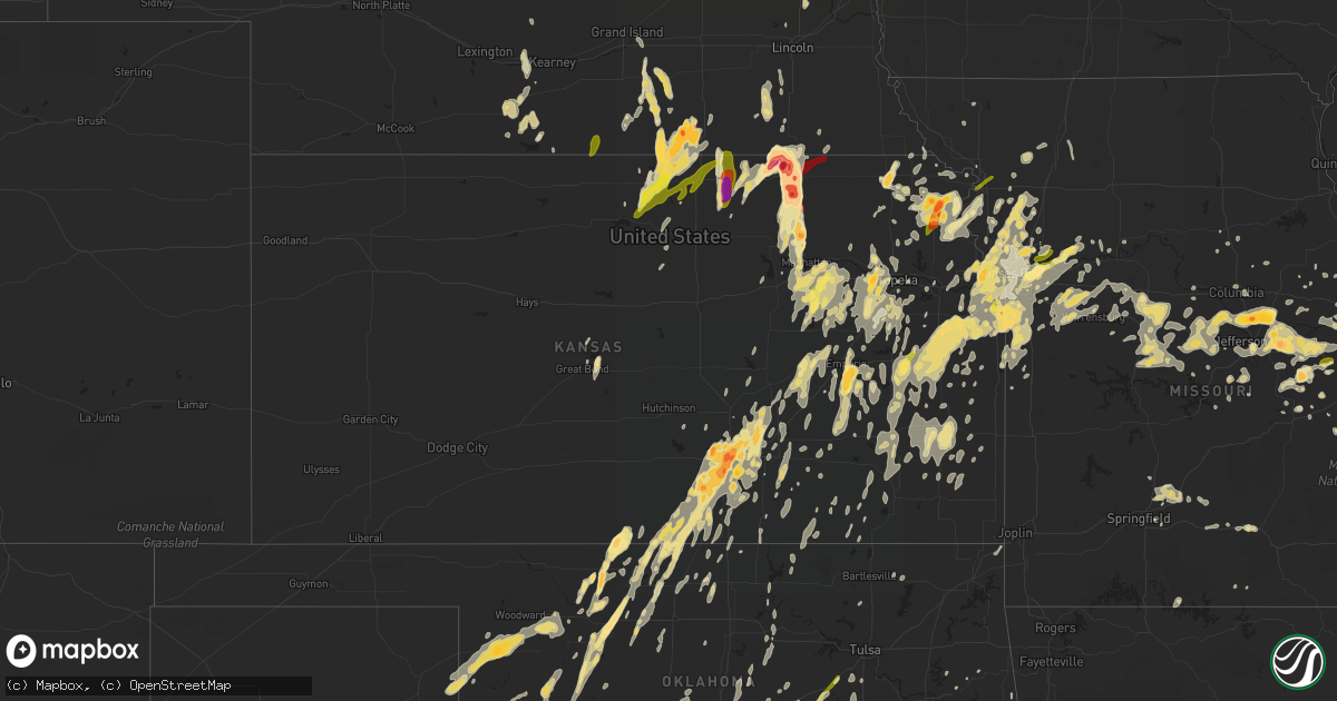
Hail Map in Kansas on April 26, 2016
Get this storm
April 26 map
$229
one time, instant access
Download today. No call, no setup
Keep the $229
Bought the map and want the full workflow? Apply the entire $229 to a subscription within 7 days. None of it is wasted.
Every map, not just this one
This buys you this map. Subscription and you get every map we run, in the markets you choose from a few cities to whole states to nationwide. Plus real-time alerts the moment a storm fires.
Contact data
Name, contact info, occupancy, even credit band for addresses in the footprint. You go from where it hit to who to call.
Become the source they trust
Unlimited branding weather history reports on demand. You already have the documented answer ready for the property owner, and you are the one who showed up with it.
Property data and RoofTrace estimates
Pull up any address you have got, its value and the exact code rules for that jurisdiction, straight from One Click Code. Then RoofTrace estimates the squares, pitch, and roof value, priced the way you price.
Storm reports in Kansas
Kansas
| Date | Description |
|---|---|
| 04/26/20166:59 PM CDT | A local report indicates 1.00 inch wind near 7 NW REPUBLIC |
| 04/26/20166:59 PM CDT | Reported at oxford cir and rock rd. |
| 04/26/20166:59 PM CDT | A local report indicates 1.00 inch wind near VIOLA |
| 04/26/20166:56 PM CDT | Official observation at the airport. |
| 04/26/20166:56 PM CDT | A local report indicates 2.00 inch wind near DOWNTOWN WICHITA |
| 04/26/20166:54 PM CDT | Official mcconnell observation. |
| 04/26/20166:52 PM CDT | Near south meridian and interstate 235. |
| 04/26/20166:51 PM CDT | Near 71st and broadway. Courtesy kwch storm chaser. |
| 04/26/20166:45 PM CDT | A local report indicates 1.50 inch wind near 3 N CLEARWATER |
| 04/26/20166:36 PM CDT | A local report indicates 1.25 inch wind near CLEARWATER |
| 04/26/20166:25 PM CDT | Quarter to half dollar size hail reported at firestation to the east of conway springs. |
| 04/26/20166:22 PM CDT | Trained spotter reported hail up to the size of quarters one half mile west of jewell. |
| 04/26/20166:15 PM CDT | Time estimated from radar |
| 04/26/20166:13 PM CDT | Report via soical media. |
| 04/26/20165:58 PM CDT | Near central and ridge. |
| 04/26/20165:54 PM CDT | Reported at 20th and caldwell road. |
| 04/26/20165:49 PM CDT | A local report indicates 1.75 inch wind near 5 SE SABETHA |
| 04/26/20165:48 PM CDT | A local report indicates 1.00 inch wind near BEL AIRE |
| 04/26/20165:47 PM CDT | Reported at oxford cir and rock rd. |
| 04/26/20165:45 PM CDT | Report via soical media. Corrected for time. |
| 04/26/20165:45 PM CDT | Delayed report. Received via twitter. |
| 04/26/20165:39 PM CDT | A local report indicates 1.50 inch wind near 2 W DOWNTOWN WICHITA |
| 04/26/20165:35 PM CDT | Reported at douglas and hillside. |
| 04/26/20165:35 PM CDT | A local report indicates 1.00 inch wind near 4 NNE BREMEN |
| 04/26/20165:33 PM CDT | A local report indicates 3.00 inch wind near 4 E HANOVER |
| 04/26/20165:33 PM CDT | Reported at hillside and douglas. |
| 04/26/20165:32 PM CDT | Measured by employee at kfdi. |
| 04/26/20165:32 PM CDT | Pawnee and interstate 135. |
| 04/26/20165:29 PM CDT | Reported in college hill. |
| 04/26/20165:27 PM CDT | Radar estimated time |
| 04/26/20165:25 PM CDT | A local report indicates 2.00 inch wind near 3 W DERBY |
| 04/26/20165:25 PM CDT | A local report indicates 2.00 inch wind near 3 WSW MARYSVILLE |
| 04/26/20165:22 PM CDT | Near 55th and broadway. Reported via twitter. |
| 04/26/20165:20 PM CDT | 1 inch hail reported by public. |
| 04/26/20165:17 PM CDT | A local report indicates 1.25 inch wind near 1 W SILVER LAKE |
| 04/26/20165:15 PM CDT | A local report indicates 1.25 inch wind near 5 W BLUE RAPIDS |
| 04/26/20165:15 PM CDT | Hail reported at west 47th and south boradway in wichita. |
| 04/26/20165:15 PM CDT | A local report indicates 1.75 inch wind near 3 S ROSSVILLE |
| 04/26/20165:12 PM CDT | Via twitter. |
| 04/26/20165:10 PM CDT | A local report indicates 1.75 inch wind near 2 E CLEARWATER |
| 04/26/20165:06 PM CDT | Reported near 55th street and ridge road. |
| 04/26/20165:06 PM CDT | A local report indicates 1.00 inch wind near 3 WNW CLYDE |
| 04/26/20165:00 PM CDT | A local report indicates 4.00 inch wind near 1 N BREMEN |
| 04/26/20165:00 PM CDT | Delayed report. |
| 04/26/20164:57 PM CDT | A local report indicates 1.00 inch wind near 2 S WASHINGTON |
| 04/26/20164:57 PM CDT | A local report indicates 1.00 inch wind near 2 E DOVER |
| 04/26/20164:56 PM CDT | A local report indicates 1.75 inch wind near 4 E CLEARWATER |
| 04/26/20164:55 PM CDT | A local report indicates 1.75 inch wind near 8 NW AUBURN |
| 04/26/20164:51 PM CDT | A local report indicates 60 MPH wind near 3 NNE DWIGHT |
| 04/26/20164:50 PM CDT | A local report indicates 1.00 inch wind near 3 E ANTHONY |
| 04/26/20164:49 PM CDT | A local report indicates 2.50 inch wind near 1 S WATERVILLE |
| 04/26/20164:49 PM CDT | Windows broken out of home. |
| 04/26/20164:49 PM CDT | A local report indicates 1.00 inch wind near 2 NW MARYSVILLE |
| 04/26/20164:48 PM CDT | Photo evidence of 2.5 inch diameter hail south of marysville. |
| 04/26/20164:48 PM CDT | A local report indicates 2.00 inch wind near 5 SW MARYSVILLE |
| 04/26/20164:45 PM CDT | A local report indicates 1.00 inch wind near DOVER |
| 04/26/20164:38 PM CDT | A local report indicates 1.00 inch wind near 9 W LATHAM |
| 04/26/20164:37 PM CDT | Relayed from trained spotter. |
| 04/26/20164:36 PM CDT | Transmitted in error...report for a different location. |
| 04/26/20164:36 PM CDT | Photo evidence of hail at least 3 inches in diameter. |
| 04/26/20164:35 PM CDT | A local report indicates 2.50 inch wind near BLUE RAPIDS |
| 04/26/20164:31 PM CDT | A local report indicates 1.75 inch wind near BLUE RAPIDS |
| 04/26/20164:30 PM CDT | A local report indicates 2.00 inch wind near WATERVILLE |
| 04/26/20164:26 PM CDT | A local report indicates 1.00 inch wind near 2 S DOVER |
| 04/26/20164:24 PM CDT | A local report indicates 1.00 inch wind near 3 W VOLLAND |
| 04/26/20164:23 PM CDT | A local report indicates 1.00 inch wind near DOVER |
| 04/26/20164:22 PM CDT | Relayed from storm spotter. |
| 04/26/20164:17 PM CDT | Half dollar size hail reported by em |
| 04/26/20164:15 PM CDT | A local report indicates 1.25 inch wind near ALTA VISTA |
| 04/26/20164:09 PM CDT | Measured by off duty nws employee near 21st and 119th. |
| 04/26/20164:08 PM CDT | Report via picture on facebook. |
| 04/26/20164:08 PM CDT | Covering the ground |
| 04/26/20164:01 PM CDT | A local report indicates 1.75 inch wind near 15 N MANHATTAN |
| 04/26/20164:00 PM CDT | Quarter to half dollars near 135th and kellogg. |
| 04/26/20164:00 PM CDT | Hail ranging from quarter to golf ball size. |
| 04/26/20163:58 PM CDT | Brief rope tornado reported |
| 04/26/20163:43 PM CDT | A local report indicates 1.00 inch wind near 1 W MANHATTAN |
| 04/26/20163:28 PM CDT | Quarter size hail reported by em. |
| 04/26/20163:27 PM CDT | Report via spotter network. |
| 04/26/20163:02 PM CDT | Report via kake tv spotter. |
| 04/26/20162:58 PM CDT | Report from kake tv. |
| 04/26/20162:53 PM CDT | A local report indicates 1.00 inch wind near 3 SE BLUFF CITY |
| 04/26/201610:00 AM CDT | 5 inch maple tree limb blown down. |
| 04/26/20168:50 AM CDT | Time approximate |
| 04/26/20167:51 AM CDT | Em reported grain roof blown off and thrown approximately 600 feet. Time estimated by radar. |
| 04/26/20167:19 AM CDT | A local report indicates 1.50 inch wind near 1 WNW EDWARDSVILLE |
| 04/26/20167:10 AM CDT | 2.25 inch hail reported. |
| 04/26/20167:03 AM CDT | Pea to golf ball size hail reported |
| 04/26/201612:16 AM CDT | Carport blown apart and siding blown off house |
| 04/25/201611:51 PM CDT | Several buildings damaged... Large trees down on south side of girard. Damage to animal hospital |
| 04/25/201611:25 PM CDT | Structure damage to building at highway 400 and wallace road. Power out across much of northern labette county. |
| 04/25/201611:24 PM CDT | Semi pulling doubles was blown over on highway 400 near the montgomery and wilson county line. |
| 04/25/201611:22 PM CDT | A local report indicates 80 MPH wind near 2 SE PARSONS |
| 04/25/201611:19 PM CDT | Power lines down. Lines down across highway 160. Power out in dennis and west parsons. |
| 04/25/201611:16 PM CDT | Estimated 60-70mph wind gust. |
| 04/25/201611:00 PM CDT | Delayed report of significant property damage to the residential and business districts of coffeyville. Numerous large trees were uprooted/damaged. Power lines and powe |
| 04/25/201610:55 PM CDT | Corrected for wind speed. |
| 04/25/201610:55 PM CDT | A local report indicates 1.00 inch wind near ALTOONA |
| 04/25/201610:36 PM CDT | A local report indicates 1.75 inch wind near 3 NNW CLEVELAND |
| 04/25/201610:26 PM CDT | A local report indicates 1.00 inch wind near 6 SSE OLATHE |
| 04/25/201610:25 PM CDT | A local report indicates 1.00 inch wind near 5 S LENEXA |
| 04/25/201610:23 PM CDT | Numerous trees down from louisburg east northeast to mo state line. |
| 04/25/201610:21 PM CDT | A local report indicates 1.00 inch wind near SHAWNEE |
| 04/25/201610:08 PM CDT | A local report indicates 1.50 inch wind near 2 SSW EDGERTON |
| 04/25/201610:08 PM CDT | A local report indicates 1.00 inch wind near 5 W PAOLA |
| 04/25/201610:00 PM CDT | 5 inch maple tree limb blown down. |
| 04/25/20169:58 PM CDT | A few trees down |
| 04/25/20169:54 PM CDT | A local report indicates 1.00 inch wind near OLATHE |
| 04/25/20169:48 PM CDT | A local report indicates 1.50 inch wind near 2 NE OTTAWA |
| 04/25/20169:47 PM CDT | A local report indicates 1.00 inch wind near 1 E OTTAWA |
| 04/25/20169:45 PM CDT | 4 inch diameter limbs snapped. |
| 04/25/20169:35 PM CDT | A local report indicates 75 MPH wind near 5 S OTTAWA |
| 04/25/20169:34 PM CDT | A local report indicates 65 MPH wind near OTTAWA |
| 04/25/20169:11 PM CDT | Quarter size hail and winds to around 60 mph estimated on i-35. |
| 04/25/20168:58 PM CDT | A local report indicates 61 MPH wind near COFFEY COUNTY AIRPORT |
| 04/25/20168:55 PM CDT | A local report indicates 1.00 inch wind near 7 W BURLINGTON |
| 04/25/20168:50 PM CDT | Time approximate |
| 04/25/20168:13 PM CDT | A local report indicates 1.00 inch wind near COTTONWOOD FALLS |
| 04/25/20168:07 PM CDT | A local report indicates 1.75 inch wind near OLPE |
| 04/25/20167:47 PM CDT | Brief tornado reported by the public and confirmed with a picture. Tornado remained in the general area for about 5 minutes. Rated an ef0 with an estimated maximum wind |
| 04/25/20167:35 PM CDT | A local report indicates 60 MPH wind near 3 WNW AUGUSTA |
| 04/25/20167:24 PM CDT | Trained spotter reports hail up to the size of quarters in formoso. |
| 04/25/20167:15 PM CDT | A local report indicates 1.50 inch wind near 4 N BENTON |
| 04/25/20167:13 PM CDT | Near central and greenwich. Courtesy of ksn. |
| 04/25/20167:10 PM CDT | A local report indicates 1.75 inch wind near 5 S HAZELTON |
| 04/25/20167:06 PM CDT | Near hydraulic and lincoln. |
All States Impacted by Hail Map on April 26, 2016
Cities Impacted by Hail Map on April 26, 2016
- Williamsburg, MO
- Fulton, MO
- Sabinal, TX
- D Hanis, TX
- Trimble, MO
- Liberty, MO
- Kearney, MO
- Jamestown, KS
- San Saba, TX
- Cherokee, TX
- McGee, MO
- Davidson, OK
- Killeen, TX
- Nowata, OK
- Matfield Green, KS
- Grove City, OH
- Groveport, OH
- Lockbourne, OH
- Columbus, OH
- Paris, IL
- Universal, IN
- Vermilion, IL
- Clinton, IN
- Chanute, KS
- Humboldt, KS
- Erie, KS
- La Harpe, KS
- Iola, KS
- Mount Vernon, IL
- Opdyke, IL
- Boyd, TX
- Hammon, OK
- Leedey, OK
- Assumption, IL
- Saint Elizabeth, MO
- Saint Thomas, MO
- Eugene, MO
- Meta, MO
- Henley, MO
- Winfield, KS
- Dexter, KS
- Burden, KS
- Fort Branch, IN
- Haubstadt, IN
- Leakey, TX
- Rio Frio, TX
- Decatur, TX
- Metropolis, IL
- Brookville, IN
- Madill, OK
- Stewartsville, MO
- Gower, MO
- Tennessee Ridge, TN
- Cumberland City, TN
- Dover, TN
- Rockwall, TX
- Manhattan, KS
- Charleston, IL
- Stanton, TX
- Winters, TX
- Ovalo, TX
- Lawn, TX
- Hollenberg, KS
- Hanover, KS
- Blanchester, OH
- Belleville, KS
- Hubbell, NE
- Narka, KS
- Cuba, KS
- Dill City, OK
- San Angelo, TX
- Christoval, TX
- Claremont, IL
- Olney, IL
- Gainesville, TX
- Burneyville, OK
- Muenster, TX
- Diboll, TX
- Olustee, OK
- Altus, OK
- Eldorado, OK
- Elmer, OK
- Vernon, TX
- Tipton, OK
- Headrick, OK
- Chillicothe, TX
- Odell, TX
- Morgantown, KY
- Caneyville, KY
- Rutland, OH
- Pomeroy, OH
- Cedar Point, KS
- Council Grove, KS
- Americus, KS
- Elmdale, KS
- Emporia, KS
- Strong City, KS
- Cottonwood Falls, KS
- Pacific, MO
- Holden, MO
- Pleasant Hill, MO
- Centerview, MO
- Kingsville, MO
- Rose Hill, KS
- Douglass, KS
- Derby, KS
- Goshen, OH
- Morrow, OH
- Pleasant Plain, OH
- Pennsboro, WV
- Lees Summit, MO
- Valmeyer, IL
- Festus, MO
- Alta Vista, KS
- Bronte, TX
- Marshfield, MO
- Owensboro, KY
- Calhoun, KY
- Bremen, KS
- Richwoods, MO
- Dittmer, MO
- De Soto, MO
- Atchison, KS
- Lancaster, KS
- Washington, KS
- Blue Rapids, KS
- Waterville, KS
- Marysville, KS
- Auburn, KS
- Maple Hill, KS
- Burlingame, KS
- Silver Lake, KS
- Topeka, KS
- Eskridge, KS
- Harveyville, KS
- Formoso, KS
- Webber, KS
- Mankato, KS
- Byron, NE
- Hebron, NE
- Courtland, KS
- Republic, KS
- Ruskin, NE
- Oak, NE
- Deshler, NE
- Jewell, KS
- Davenport, NE
- Hardy, NE
- Fairfield, NE
- Ellinwood, KS
- Great Bend, KS
- Alum Bridge, WV
- Auburn, WV
- Walker, WV
- Coxs Mills, WV
- Pullman, WV
- Harrisville, WV
- Linn, WV
- New Milton, WV
- Cairo, WV
- Berea, WV
- Troy, WV
- Petroleum, WV
- Waverly, WV
- Alva, OK
- Burlington, OK
- Waldron, KS
- Kiowa, KS
- Carmen, OK
- Hazelton, KS
- Dacoma, OK
- Amorita, OK
- Cherokee, OK
- Camden, MO
- Richmond, MO
- Moran, KS
- Cincinnati, OH
- Ft Mitchell, KY
- Hebron, KY
- Erlanger, KY
- Anderson, IN
- Pendleton, IN
- Markleville, IN
- Quenemo, KS
- Melvern, KS
- Williamsburg, KS
- Pomona, KS
- Bloomfield, KY
- Bluff City, KS
- Anthony, KS
- Lawrenceburg, IN
- Llano, TX
- Baird, TX
- Independence, MO
- Buckner, MO
- Yancey, TX
- Bigfoot, TX
- Moore, TX
- Devine, TX
- Charlotte, TX
- Pearsall, TX
- Poteet, TX
- Jourdanton, TX
- Cabool, MO
- Mountain Grove, MO
- Calhoun, IL
- Parkersburg, IL
- Sonora, TX
- Sardinia, OH
- Blanchard, OK
- Holliday, TX
- Elm Creek, NE
- Wichita, KS
- Martinsville, IN
- Greencastle, IN
- Reelsville, IN
- Brazil, IN
- Putnamville, IN
- Cloverdale, IN
- Quincy, IN
- Winnie, TX
- Cleveland, TX
- Willis, TX
- Wichita Falls, TX
- Burnt Prairie, IL
- Golden Gate, IL
- Anson, TX
- Strafford, MO
- Belle, MO
- Joaquin, TX
- Mansfield, LA
- Logansport, LA
- Wright City, MO
- Ottawa, KS
- Wellsville, KS
- Morrowville, KS
- Francisco, IN
- Garden City, TX
- Midland, TX
- Lampasas, TX
- Kempner, TX
- Golconda, IL
- Harvard, NE
- Glenvil, NE
- Nelson, NE
- Deweese, NE
- Edgar, NE
- Clay Center, NE
- Bloomington, IN
- Olpe, KS
- Madison, KS
- Hartford, KS
- Alma, KS
- Wamego, KS
- Shawnee, KS
- Kansas City, KS
- Bonner Springs, KS
- Ballwin, MO
- Kingfisher, OK
- Okarche, OK
- Cashion, OK
- Breese, IL
- Okawville, IL
- Mascoutah, IL
- Marissa, IL
- Germantown, IL
- Aviston, IL
- Lenzburg, IL
- Trenton, IL
- New Baden, IL
- Bartelso, IL
- Saint Libory, IL
- Albers, IL
- Addieville, IL
- Freeburg, IL
- Jamestown, OH
- Xenia, OH
- Fairview, OK
- Walton, WV
- Mason, TX
- Wingate, TX
- Washington Court House, OH
- Jeffersonville, OH
- Oran, MO
- Bell City, MO
- Moline, KS
- Elk Falls, KS
- Holdrege, NE
- Arlington, IN
- Rushville, IN
- Cleveland, MO
- Bucyrus, KS
- Louisburg, KS
- Belton, MO
- Stilwell, KS
- Kansas City, MO
- Raymore, MO
- Peculiar, MO
- Overland Park, KS
- Voss, TX
- Ballinger, TX
- Hermleigh, TX
- Robards, KY
- El Reno, OK
- De Witt, NE
- Plymouth, NE
- Blue Hill, NE
- Lawrence, NE
- Rueter, MO
- Protem, MO
- Lexington, IN
- Scottsburg, IN
- Butler, OK
- Canute, OK
- Clinton, OK
- Caulfield, MO
- Clarksville, OH
- Wilmington, OH
- Wellington, KS
- Mayfield, KS
- Graham, MO
- Calumet, OK
- Sterling City, TX
- Harrisonville, MO
- Coalgate, OK
- Atoka, OK
- Bland, MO
- Merkel, TX
- Del Rio, TX
- Snyder, TX
- Evant, TX
- Blackwell, MO
- Quanah, TX
- Dixon, KY
- Enid, OK
- Drummond, OK
- Waukomis, OK
- Denton, KS
- Cummings, KS
- Effingham, KS
- Bendena, KS
- Everest, KS
- Mokane, MO
- Ira, TX
- Rotan, TX
- Sweetwater, TX
- Palestine, TX
- Tennessee Colony, TX
- Montalba, TX
- Castor, LA
- Bienville, LA
- Coushatta, LA
- Ashland, LA
- Republican City, NE
- Naponee, NE
- Sedalia, MO
- Smithton, MO
- Stover, MO
- Versailles, MO
- Lincoln, MO
- Cole Camp, MO
- Mora, MO
- Hartville, MO
- Saint James, MO
- Rolla, MO
- Labadie, MO
- Washington, MO
- Villa Ridge, MO
- Fair Grove, MO
- Flat Rock, IN
- Saint Paul, IN
- Greensburg, IN
- Horton, KS
- Powhattan, KS
- Kingston, OK
- Mulvane, KS
- Belle Plaine, KS
- Cedar Hill, MO
- Weinert, TX
- Hamlin, TX
- Rule, TX
- Knox City, TX
- O'Brien, TX
- Haskell, TX
- Rochester, TX
- Aspermont, TX
- Stamford, TX
- Mena, AR
- Bidwell, OH
- Paden, OK
- Crawfordsville, IN
- Eldorado, TX
- Pilot Point, TX
- Collinsville, TX
- Valley View, TX
- Tioga, TX
- Grandview, MO
- Hunter, OK
- Lamont, OK
- Garber, OK
- Yellow Springs, OH
- Fairborn, OH
- Wynnewood, OK
- Davis, OK
- Chesterfield, MO
- Saint Louis, MO
- Middletown, OH
- Converse, LA
- Zavalla, TX
- Broaddus, TX
- Pineland, TX
- Hemphill, TX
- Wiergate, TX
- Brookeland, TX
- Bronson, TX
- Ozona, TX
- Waverly, OH
- Beaver, OH
- Elkland, MO
- Niangua, MO
- Conway, MO
- Saronville, NE
- Sutton, NE
- Steelville, MO
- Salem, MO
- Wesco, MO
- Rocksprings, TX
- Russellville, MO
- California, MO
- Junction, IL
- Equality, IL
- Marlow, OK
- Duncan, OK
- Bethel, OH
- Silsbee, TX
- Excelsior Springs, MO
- Tebbetts, MO
- Junction, TX
- London, TX
- Crowell, TX
- Wadesville, IN
- Mount Vernon, IN
- Caldwell, KS
- South Haven, KS
- Clay, WV
- Summersville, WV
- Eldorado, IL
- Carrier Mills, IL
- Harrisburg, IL
- Sullivan, IL
- Henrietta, TX
- Funk, NE
- Millersview, TX
- Rosston, TX
- Lindsay, TX
- Era, TX
- Waltonville, IL
- Fairview, KS
- Sabetha, KS
- Morrill, KS
- Hiawatha, KS
- Boonville, IN
- Richland, IN
- Tennyson, IN
- Chrisney, IN
- Kemp, TX
- Kaufman, TX
- Mabank, TX
- Hartsburg, MO
- New Bloomfield, MO
- Ashland, MO
- Comanche, TX
- De Leon, TX
- Dublin, TX
- Plattsburg, MO
- Eureka, MO
- High Ridge, MO
- House Springs, MO
- Little Elm, TX
- Centralia, IL
- West Union, WV
- Chester, TX
- Princeton, IN
- Patoka, IN
- Cedar Vale, KS
- Louisville, KY
- Sims, IL
- Geff, IL
- Fairfield, IL
- Lone Wolf, OK
- Carter, OK
- Sentinel, OK
- Granite, OK
- Herod, IL
- Eddyville, IL
- Grantsburg, IL
- Simpson, IL
- Truxton, MO
- Bellflower, MO
- Batavia, OH
- Milford, OH
- Tecumseh, KS
- Williamsport, OH
- Circleville, OH
- Drexel, MO
- Spring Hill, KS
- Archie, MO
- Olathe, KS
- Freeman, MO
- Neosho Rapids, KS
- Hamilton, KS
- Lebo, KS
- Eureka, KS
- Centerville, KS
- Agency, MO
- Purcell, OK
- Oklahoma City, OK
- Lindsay, OK
- Washington, OK
- Norman, OK
- Monrovia, IN
- Burns, KS
- Greenwood, IN
- Olsburg, KS
- Carleton, NE
- Falls City, TX
- Campbellton, TX
- Pleasanton, TX
- Crawford, OK
- Roscoe, TX
- Maryneal, TX
- Abilene, TX
- Colorado City, TX
- Breckenridge, TX
- Westbrook, TX
- Dyess Afb, TX
- Robert Lee, TX
- Blackwell, TX
- Nolan, TX
- Tuscola, TX
- Albany, TX
- Clyde, TX
- Tye, TX
- Moran, TX
- Loraine, TX
- Wahoo, NE
- Ithaca, NE
- Nash, OK
- Leon, WV
- Rossville, KS
- Delia, KS
- Troy, IN
- Evanston, IN
- Oakwood, OK
- Seiling, OK
- Floresville, TX
- Mooreland, OK
- Burnet, TX
- Kingsland, TX
- Buchanan Dam, TX
- Blue Springs, MO
- Otway, OH
- Peebles, OH
- Latham, OH
- Piketon, OH
- Hillsboro, OH
- Rarden, OH
- Clyde, KS
- Agenda, KS
- Edgerton, KS
- De Kalb, MO
- Superior, NE
- Buna, TX
- Vidor, TX
- Spencer, IN
- Solsberry, IN
- Charleston, MO
- New Madrid, MO
- East Prairie, MO
- Osgood, IN
- Batesville, IN
- New Athens, IL
- Summerfield, IL
- Lebanon, IL
- Greenwich, KS
- Kechi, KS
- Peck, KS
- Potwin, KS
- Conway Springs, KS
- Viola, KS
- Valley Center, KS
- Wakita, OK
- Benton, KS
- Milan, KS
- Whitewater, KS
- Argonia, KS
- Towanda, KS
- Medford, OK
- Manchester, OK
- Augusta, KS
- Goddard, KS
- Clearwater, KS
- Andover, KS
- Colwich, KS
- Maize, KS
- Haysville, KS
- Vichy, MO
- Burlington, KS
- Waverly, KS
- Ashley, IL
- Nashville, IL
- Mineral Wells, TX
- Lumberton, TX
- Wolfe City, TX
- New Lexington, OH
- Crooksville, OH
- Somerset, OH
- Corning, OH
- Roseville, OH
- Reydon, OK
- Gainesville, MO
- Odessa, MO
- Lexington, MO
- Mayview, MO
- Evansville, IN
- Houstonia, MO
- Hughesville, MO
- Miamiville, OH
- Loveland, OH
- Camp Dennison, OH
- Mullin, TX
- Goldthwaite, TX
- Borden, IN
- Greenville, IN
- Floyds Knobs, IN
- Annapolis, MO
- Pittsfield, IL
- Loving, TX
- Olney, TX
- Graham, TX
- Rogersville, MO
- Belvidere, NE
- Bruning, NE
- Chamois, MO
- Hermann, MO
- Morrison, MO
- Rockville, IN
- Montezuma, IN
- Cross Plains, TX
- Menard, TX
- Melvin, TX
- Piedmont, KS
- Grenola, KS
- Henderson, KY
- Mountain Park, OK
- Indiahoma, OK
- Snyder, OK
- Lawton, OK
- Roosevelt, OK
- Virgil, KS
- Junction City, KS
- Dwight, KS
- Eldon, MO
- Lawrence, KS
- Sedan, KS
- Peru, KS
- Harper, TX
- Doss, TX
- Oak Hill, OH
- Justin, TX
- Ponder, TX
- Arkansas City, KS
- Poolville, TX
- Bridgeport, TX
- Santa Anna, TX
- Coleman, TX
- Stilesville, IN
- Coatesville, IN
- Fillmore, IN
- Benjamin, TX
- Munday, TX
- Seymour, TX
- Aubrey, TX
- Denton, TX
- Syracuse, OH
- Sandyville, WV
- Le Roy, WV
- Racine, OH
- West Columbia, WV
- Portland, OH
- Langsville, OH
- Middleport, OH
- Mason, WV
- Hartford, WV
- Ravenswood, WV
- Leesburg, OH
- Waterloo, IL
- Garnett, KS
- Nevada, TX
- Royse City, TX
- Novice, TX
- Talpa, TX
- Glenwood, IN
- Rising Star, TX
- Cisco, TX
- Bunceton, MO
- Uvalde, TX
- McClure, IL
- Cape Girardeau, MO
- Utica, KY
- Wilber, NE
- Lyndon, KS
- Overbrook, KS
- Vassar, KS
- Georgetown, OH
- Bellevue, KY
- Latonia, KY
- Covington, KY
- Amelia, OH
- Fort Thomas, KY
- Melbourne, KY
- Newport, KY
- New Richmond, OH
- Mount Orab, OH
- Dayton, KY
- Williamsburg, OH
- Hamersville, OH
- Winchester, OH
- Silver Grove, KY
- Alexandria, KY
- Seaman, OH
- Midland, OH
- Delaware, OK
- Leslie, MO
- Gerald, MO
- Eastland, TX
- Carbon, TX
- Jamestown, MO
- New Vienna, OH
- Richland Springs, TX
- Rochelle, TX
- Charlottesville, IN
- Wills Point, TX
- Walters, OK
- Randall, KS
- Scandia, KS
- Straughn, IN
- New Castle, IN
- Columbia, MO
- Inland, NE
- Trumbull, NE
- Galloway, OH
- Norborne, MO
- Sweetwater, OK
- Randolph, KS
- East Alton, IL
- Perrin, TX
- Graford, TX
- Chandler, IN
- Gandeeville, WV
- Linn, MO
- Tuscumbia, MO
- Fort Cobb, OK
- Carnegie, OK
- Crofton, KY
- Dawson Springs, KY
- Mcconnelsville, OH
- Stockport, OH
- Blue Rock, OH
- Malta, OH
- Glenford, OH
- Mount Perry, OH
- Thornville, OH
- Millersport, OH
- Pleasantville, OH
- Owensville, MO
- Dudley, MO
- Byars, OK
- Stratford, OK
- Ada, OK
- Eufaula, OK
- Mansfield, MO
- Macomb, MO
- Willisburg, KY
- Harrodsburg, KY
- Lawrenceburg, KY
- Wallback, WV
- Maysel, WV
- Athens, TX
- Waynoka, OK
- Du Quoin, IL
- Vergennes, IL
- Gray Summit, MO
- Holton, IN
- Butlerville, IN
- Knightstown, IN
- Carthage, IN
- Greenfield, IN
- Wilkinson, IN
- West Paducah, KY
- Latham, MO
- Fortuna, MO
- Tipton, MO
- Tilden, TX
- Calliham, TX
- Beatrice, NE
- Gustine, TX
- Ferdinand, IN
- Corrigan, TX
- Livingston, TX
- Liberty, NE
- Burchard, NE
- Walkersville, WV
- Orlando, WV
- Weston, WV
- Shelbyville, IN
- Fountaintown, IN
- Morristown, IN
- Fairland, IN
- New Palestine, IN
- Jefferson City, MO
- Reading, KS
- Amanda, OH
- Lancaster, OH
- Rockbridge, OH
- Laurelville, OH
- Sidney, TX
- Deer, AR
- Canton, TX
- Griggsville, IL
- Terre Haute, IN
- Helena, OK
- Cleo Springs, OK
- Aline, OK
- Chandler, OK
- Agra, OK
- Hepler, KS
- Beaumont, TX
- Longdale, OK
- South Charleston, OH
- South Solon, OH
- Cedarville, OH
- Hillsboro, MO
- Ringgold, TX
- Nocona, TX
- Poland, IN
- Bowling Green, IN
- Lynnville, IN
- Rockport, IN
- Owensville, IN
- Decker, IN
- Hazleton, IN
- Oakland City, IN
- Elberfeld, IN
- Newburgh, IN
- Petersburg, IN
- Cynthiana, IN
- Poseyville, IN
- Gentryville, IN
- Vincennes, IN
- New Harmony, IN
- Reed, KY
- Benedict, KS
- Buffalo, KS
- Fredonia, KS
- Yates Center, KS
- Clarksburg, MO
- Leon, KS
- Atlanta, KS
- Amherst, NE
- Rock, KS
- Custer City, OK
- Natalia, TX
- Hondo, TX
- Niotaze, KS
- Vienna, MO
- Moberly, MO
- Gardner, KS
- Underwood, IN
- Bonnots Mill, MO
- Jonesville, KY
- Dry Ridge, KY
- Glencoe, KY
- Noble, IL
- Barnes, KS
- Leonardville, KS
- Odell, NE
- Linn, KS
- Wymore, NE
- Riley, KS
- Diller, NE
- Taloga, OK
- Lenexa, KS
- Lynchburg, OH
- Martinsville, OH
- Rantoul, KS
- Princeton, KS
- Emory, TX
- Hamilton, TX
- Oak Grove, MO
- Grain Valley, MO
- Brownwood, TX
- Leawood, KS
- Riverside, MO
- Groveton, TX
- Elk City, KS
- Chester, OK
- Greeley, KS
- Edmond, OK
- Quinlan, TX
- Bertrand, MO
- Bristow, OK
- Kellyville, OK
- Hennessey, OK
- Lucasville, OH
- McDermott, OH
- Windsor, IL
- Gays, IL
- Hennepin, OK
- Elmore City, OK
- Franklin, OH
- Osage City, KS
- Carbondale, KS
- Scranton, KS
- Allen, KS
- Admire, KS
- La Grange, KY
- Smithfield, KY
- Kountze, TX
- Pembroke, KY
- Edgewood, TX
- Lincolnville, KS
- Marion, KS
- Ramona, KS
- Copperas Cove, TX
- Enon, OH
- Springfield, OH
- Dayton, OH
- New Carlisle, OH
- Medway, OH
- West Chester, OH
- Hamilton, OH
- Rosebud, MO
- Carrier, OK
- Goltry, OK
- Elsmore, KS
- Savonburg, KS
- Eden, TX
- Vancourt, TX
- Fort Scott, KS
- Alma, NE
- Orleans, NE
- Pauls Valley, OK
- Paoli, OK
- Stroud, OK
- Greenwood, MO
- Foss, OK
- Liberty, IN
- Newton, KS
- North Bend, OH
- Woodville, TX
- Sharon, OK
- Gatesville, TX
- Jonesboro, TX
- Brackettville, TX
- Mount Sterling, MO
- El Dorado, KS
- Gorman, TX
- Belton, TX
- Cedar Grove, IN
- Castell, TX
- Fredericksburg, TX
- Grand Saline, TX
- Purmela, TX
- Branchville, IN
- Smithland, KY
- Manitou, KY
- Hanson, KY
- Madisonville, KY
- Jacksboro, TX
- Pawnee, OK
- Glencoe, OK
- Saint Peters, MO
- Saint Charles, MO
- Marland, OK
- Ralston, OK
- Sedgwick, KS
- Bowie, TX
- Toronto, KS
- Basehor, KS
- Waldron, MO
- Prairie Village, KS
- Holt, MO
- Smithville, MO
- Mission, KS
- Platte City, MO
- Edgerton, MO
- Tonganoxie, KS
- Chaffee, MO
- Advance, MO
- Scott Air Force Base, IL
- Bardwell, KY
- Rosedale, IN
- Carbon, IN
- Bridgeton, IN
- Lathrop, MO
- Irvine, KY
- Forestburg, TX
- Alvord, TX
- Parkersburg, WV
- Dearborn, MO
- Faucett, MO
- King City, MO
- Amity, MO
- Maysville, MO
- Sunman, IN
- Paola, KS
- Barksdale, TX
- Eaton, OH
- Connersville, IN
- Camden, OH
- Brownsville, IN
- College Corner, OH
- Sharpsburg, KY
- Owingsville, KY
- Comstock, TX
- Vienna, WV
- Fleming, OH
- Belpre, OH
- Marietta, OH
- Laurel, IN
- Neosho Falls, KS
- Linwood, KS
- Osborn, MO
- Osawatomie, KS
- Adrian, MO
- New Century, KS
- Orrick, MO
- Henrietta, MO
- Westphalia, KS
- Butler, MO
- Bates City, MO
- Turney, MO
- Napoleon, MO
- Hardin, MO
- Cameron, MO
- Sibley, MO
- Welda, KS
- Colony, KS
- De Soto, KS
- Le Roy, KS
- Amsterdam, MO
- La Cygne, KS
- Richmond, KS
- Wellington, MO
- Baldwin City, KS
- Altoona, KS
- Lesterville, MO
- Warrenton, MO
- Foster, OK
- Crete, NE
- Martell, NE
- Clatonia, NE
- Hallam, NE
- Arnett, OK
- Sharon Grove, KY
- McFarland, KS
- Saint George, KS
- Paxico, KS
- Clifton, KS
- Oketo, KS
- Haddam, KS
- Knob Noster, MO
- Moro, AR
- Rhineland, MO
- Portland, MO
- Montgomery City, MO
- Rowena, TX
- Oldenburg, IN
- Saint Albans, MO
- Defiance, MO
- Augusta, MO
- Wildwood, MO
- Cache, OK
- Bertrand, NE
- Oxford, NE
- Atlanta, NE
- Pelican, LA
- Pleasant Hill, LA
- Troy, KS
- Muscotah, KS
- Rushville, MO
- Nortonville, KS
- Whiting, KS
- Reedsville, OH
- Paragon, IN
- Gosport, IN
- Ripley, WV
- Given, WV
- Udall, KS
- Calico Rock, AR
- Otisco, IN
- Marysville, IN
- Saint Paul, KS
- Asher, OK
- Waldron, IN
- Alhambra, IL
- Marine, IL
- Weatherford, TX
- Berryton, KS
- Morganfield, KY
- Vienna, IL
- Letart, WV
- Guide Rock, NE
- Woodward, OK
- Falls City, NE
- Weston, MO
- Winchester, KS
- Saint Joseph, MO
- Easton, KS
- Sullivan, MO
- Jasper, TX
- Colmesneil, TX
- Hillister, TX
- Choctaw, OK
- Arcadia, OK
- Spencer, OK
- Luther, OK
- Jones, OK
- Procious, WV
- Amma, WV
- Rosalia, KS
- Barnard, KS
- Camp, AR
- Warrensburg, MO
- Berger, MO
- McLouth, KS
- Oakwood, TX
- Throckmorton, TX
- Terrell, TX
- Crawford, TX
- Lebanon, OH
- Freeburg, MO
- Frederick, OK
- Gracemont, OK
- Mountain View, OK
- Frankfort, KY
- Winchester, IL
- San Antonio, TX
- Vallonia, IN
- Brownstown, IN
- Harrah, OK
- Sheridan, IN
- Williamstown, WV
- Glenville, WV
- Burnsville, WV
- Cutler, OH
- Stewart, OH
- Vincent, OH
- Millfield, OH
- Athens, OH
- Amesville, OH
- Dahlgren, IL
- Metamora, IN
- Canadian, TX
- Durham, OK
- Rhome, TX
- Meno, OK
- Ranger, TX
- Sumner, IL
- Chester, NE
- Sour Lake, TX
- China, TX
- Elkton, KY
- Barnhart, MO
- Herculaneum, MO
- Pevely, MO
- Horseshoe Bend, AR
- Highland, KS
- White Cloud, KS
- Ringwood, OK
- Cheshire, OH
- May, TX
- Berry, KY
- Cynthiana, KY
- Noble, OK
- Lexington, OK
- Krum, TX
- Higginsville, MO
- Aurora, NE
- Giltner, NE
- Phillips, NE
- Mount Sterling, OH
- Lone Jack, MO
- Mount Judea, AR
- Mapleton, KS
- Bronson, KS
- Uniontown, KS
- Georgetown, KY
- Midway, KY
- Hendrix, OK
- Denison, TX
- Anadarko, OK
- Ellenboro, WV
- Arnold, NE
- Southside, WV
- Milroy, IN
- Stonefort, IL
- Chico, TX
- Rocky Mount, MO
- Barnett, MO
- Art, TX
- Salt Lick, KY
- Morehead, KY
- Stewart, TN
- Springtown, TX
- Walnut, KS
- North Vernon, IN
- Westport, IN
- Stilwell, OK
- Liberty, TX
- Sanger, TX
- Fort Riley, KS
- Imperial, MO
- Columbia, IL
- Streetman, TX
- Richland, TX
- Reedy, WV
- Palestine, WV
- Paducah, KY
- Cunningham, KY
- Gordon, TX
- South Lebanon, OH
- Fayetteville, OH
- Maineville, OH
- Mutual, OK
- Hillsdale, IN
- Marthasville, MO
- Union, MO
- New Haven, MO
- Foristell, MO
- Coxs Creek, KY
- Lometa, TX
- Gouldbusk, TX
- Valera, TX
- Old Glory, TX
- Sylvester, TX
- McFall, MO
- Pattonsburg, MO
- Waterford, OH
- Elk City, OK
- Luebbering, MO
- Grubville, MO
- Robertsville, MO
- Arnold, MO
- Catawissa, MO
- Lonedell, MO
- Burkett, TX
- Cutler, IL
- Milton, KS
- Troy, IL
- Lavon, TX
- Rockwood, IL
- Otterville, MO
- Florence, MO
- Sweet Springs, MO
- Pilot Grove, MO
- Concordia, MO
- Garden City, MO
- Corder, MO
- La Monte, MO
- Nelson, MO
- Ionia, MO
- Huntsville, TX
- Mayetta, KS
- Fults, IL
- Crystal City, MO
- Orange, TX
- Norwood, MO
- Beaufort, MO
- Freeport, KS
- Mcconnell Afb, KS
- Thomas, OK
- Jet, OK
- Danville, KS
- Oxford, KS
- Okeene, OK
- Isabella, OK
- Ames, OK
- Lahoma, OK
- Bicknell, IN
- Ragsdale, IN
- Wheatland, IN
- Marble Hill, MO
- Marietta, OK
- Thackerville, OK
- Hodgen, OK
- Alpha, OH
- Moscow, TX
- Seguin, TX
- Byers, TX
- Wakarusa, KS
- Millsap, TX
- Fort Worth, TX
- Florissant, MO
- West Alton, MO
- Hanover, IN
- Madison, IN
- Lohn, TX
- Nardin, OK
- Braman, OK
- Lockport, KY
- Fletcher, MO
- Noblesville, IN
- Beloit, KS
- Bertram, TX
- Wellsville, MO
- Bainbridge, OH
- Marshall, IL
- Owenton, KY
- Newcastle, TX
- Bourbon, MO
- Goshen, KY
- Westport, KY
- Wayne, OK
- Maysville, OK
- Checotah, OK
- Bloomingburg, OH
- Saint Jacob, IL
- Redfield, KS
- Clarksdale, MO
- McCune, KS
- Girard, KS
- Hillsboro, KY
- Valley Falls, KS
- Wetmore, KS
- Robinson, KS
- Tuttle, OK
- Minco, OK
- Grandview, IN
- Newalla, OK
- Mcloud, OK
- Lohman, MO
- Westphalia, MO
- Valley Park, MO
- Maryland Heights, MO
- Bridgeton, MO
- Centertown, MO
- Holts Summit, MO
- Loose Creek, MO
- O'Fallon, MO
- Electra, TX
- Chickasha, OK
- Simpsonville, KY
- Seymour, IN
- Gage, OK
- Fargo, OK
- Bangs, TX
- Florence, TX
- Briggs, TX
- Kiefer, OK
- Mounds, OK
- Glenpool, OK
- Gridley, KS
- Utopia, TX
- Alma, AR
- Pleasureville, KY
- Tahlequah, OK
- Springfield, MO
- Bellevue, TX
- Bluffs, IL
- Meredosia, IL
- Spencer, WV
- Whitesboro, TX
- Boonville, MO
- Eudora, KS
- Meeker, OK
- Middletown, MO
- Groves, TX
- Port Arthur, TX
- Shade, OH
- Cuba, MO
- Dongola, IL
- Iberia, MO
- Ulman, MO
- Sparta, KY
- Red Bud, IL
- Zanesville, OH
- Vinton, OH
- West Jefferson, OH
- East Saint Louis, IL
- Venice, IL
- Lovejoy, IL
- Oakdale, IL
- Sunset, TX
- Montague, TX
- Cushing, OK
- Norris City, IL
- Broughton, IL
- Hope, IN
- Shawneetown, IL
- Mattoon, IL
- Dover, MO
- Saint Clair, MO
- Saint Croix, IN
- Derby, IN
- Tell City, IN
- Clayton, IN
- Mooresville, IN
- Camby, IN
- Bargersville, IN
- Telephone, TX
- Brady, TX
- Corn, OK
- Marshall, OK
- Burr Oak, KS
- West Terre Haute, IN
- Zalma, MO
- Ceresco, NE
- London, OH
- West Union, OH
- Mount Erie, IL
- Hawley, TX
- Newkirk, OK
- Heavener, OK
- Matthews, MO
- Roby, TX
- Bloomfield, IN
- Versailles, KY
- Nashville, IN
- Jackson, MO
- Circleville, KS
- Soldier, KS
- Wayne City, IL
- Wathena, KS
- Waterloo, OH
- Pedro, OH
- Lane, KS
- Fontana, KS
- Parker, KS
- Morrison, OK
- Brookesmith, TX
- Jameson, MO
- Coffey, MO
- Gallatin, MO
- Meridian, OK
- Coyle, OK
- Guthrie, OK
- Waveland, IN
- Mountain View, AR
- Ennis, TX
- Scottown, OH
- Willow Wood, OH
- Chillicothe, OH
- Bluford, IL
- Haven, KS
- Fairview Heights, IL
- O'Fallon, IL
- Catlettsburg, KY
- Kenova, WV
- Huntington, WV
- Atlanta, IN
- Fowlerton, TX
- Bruceville, IN
- Union City, OK
- Lawson, MO
- Leavenworth, KS
- Hico, TX
- New Franklin, MO
- Franklin, MO
- Pontotoc, TX
- Carlinville, IL
- Gillespie, IL
- Longton, KS
- Clendenin, WV
- Raymond, NE
- Spottsville, KY
- Petrolia, TX
- Windthorst, TX
- Bokchito, OK
- Cheyenne, OK
- Ryan, OK
- Lodi, MO
- Silva, MO
- Kevil, KY
- Melber, KY
- Bloomsdale, MO
- Manilla, IN
- Homer, IN
- Ashland, KY
- Barnsdall, OK
- Skiatook, OK
- Mason, OH
- Saint Marys, WV
- Claflin, KS
- Ponca City, OK
- Grand Chain, IL
- Ullin, IL
- Karnak, IL
- Marlin, TX
- Odon, IN
- New Holland, OH
- Pond Creek, OK
- Briscoe, TX
- Goldsboro, TX
- Norton, TX
- Oklaunion, TX
- Couch, MO
- Pocahontas, AR
- Myrtle, MO
- Hoisington, KS
- Mount Alto, WV
- Trenton, KY
- Hopewell, OH
- Heath, OH
- Clearfield, KY
- Fairfield, TX
- Teague, TX
- Stoutsville, OH
- Lyford, TX
- Sebastian, TX
- San Perlita, TX
- Pollok, TX
- Wilson, OK
- Overbrook, OK
- Addyston, OH
- Independence, KY
- Terrace Park, OH
- Petersburg, KY
- Aurora, IN
- Clay, KY
- Reno, OH
- Newport, OH
- New Matamoras, OH
- Philpot, KY
- Quapaw, OK
- Miami, OK
- Galatia, IL
- Plainfield, IN
- Whiteland, IN
- Peabody, KS
- Shepherd, TX
- Lexington, KY
- Crothersville, IN
- Austin, IN
- Pulaski, IL
- Villa Ridge, IL
- Olmsted, IL
- Spring Valley, OH
- Waynesville, OH
- Princeton, KY
- Saint Charles, KY
- Nortonville, KY
- Cerulean, KY
- Cement, OK
- Strawn, TX
- Perkins, OK
- Stillwater, OK
- Bloomfield, MO
- Salvisa, KY
- Syracuse, MO
- Fayetteville, AR
- West Fork, AR
- Hoyt, KS
- Carlyle, IL
- La Vernia, TX
- Saint Hedwig, TX
- Stockdale, TX
- Stark, KS
- Camp Wood, TX
- Sebree, KY
- Campbellsburg, KY
- Bedford, KY
- Shelbyville, KY
- Argyle, TX
- Du Bois, IL
- Tamaroa, IL
- Sapulpa, OK
- Stephenville, TX
- Elkins, AR
- Big Spring, TX
- Marshall, AR
- Walnut Hill, IL
- Oconee, IL
- Avoca, TX
- Lapel, IN
- Blue Mound, KS
- Piedmont, OK
- Sherman, TX
- Mustang, OK
- Whiteman Air Force Base, MO
- Bickmore, WV
- Camden Point, MO
- Jeffersonville, IN
- Higbee, MO
- Silex, MO
- Hawk Point, MO
- Doole, TX
- Green Ridge, MO
- Windsor, MO
- Gunter, TX
- Howe, TX
- Galesburg, KS
- Thayer, KS
- McLeansboro, IL
- Indianapolis, IN
- Dille, WV
- Scotland, TX
- Early, TX
- Leonard, TX
- Blue Ridge, TX
- Trenton, TX
- New Liberty, KY
- Crown City, OH
- Holton, KS
- Guilford, IN
- Centerpoint, IN
- Cory, IN
- Ripley, OK
- Evans, WV
- Wilkesville, OH
- Long Bottom, OH
- Albany, OH
- Millwood, WV
- Cottageville, WV
- Hoyleton, IL
- Dixon, MO
- Martinsburg, MO
- Pickerington, OH
- Canal Winchester, OH
- Jonesburg, MO
- High Hill, MO
- Lead Hill, AR
- Cedarcreek, MO
- Wilberforce, OH
- Whitewater, MO
- Amazonia, MO
- Mammoth Spring, AR
- Bradley, OK
- Alex, OK
- Rush Springs, OK
- Alba, TX
- La Center, KY
- Okmulgee, OK
- Beggs, OK
- Caddo, TX
- Desdemona, TX
- Foster, MO
- Carrollton, MO
- Cassoday, KS
- Chariton, IA
- Coahoma, TX
- Corsicana, TX
- Buffalo, MO
- Half Way, MO
- Point Pleasant, WV
- Alum Creek, WV
- Sod, WV
- Sumerco, WV
- Mineral Point, MO
- Watonga, OK
- Latham, KS
- Yukon, OK
- Saint Jo, TX
- Montreal, MO
- Brumley, MO
- Terral, OK
- Denison, KS
- Centralia, MO
- Thompson, MO
- Blair, OK
- Mangum, OK
- Hulbert, OK
- Fort Gibson, OK
- Murphysboro, IL
- Elkville, IL
- Lewisport, KY
- Bagdad, KY
- Moorefield, KY
- Hopkinsville, KY
- Independence, KS
- Paris, KY
- Hartford, KY
- Clark, MO
- Grand Cane, LA
- Apache, OK
- Cyril, OK
- Hollister, OK
- Wellston, OK
- Maryville, MO
- Madison, MO
- Belvue, KS
- Macedonia, IL
- Corinth, KY
- Vandalia, IL
- Keyesport, IL
- Erin, TN
- Highland, IL
- Pocahontas, IL
- Pekin, IN
- Salem, IN
- Sulphur Springs, AR
- Gravette, AR
- Vanderpool, TX
- Allentown, NJ
- Trenton, NJ
- Robbinsville, NJ
- Looneyville, WV
- Left Hand, WV
- Mcalester, OK
- Proctor, OK
- Mounds, IL
- West Salem, IL
- Marshall, IN
- Wilsey, KS
- Ogden, KS
- White City, KS
- Palmer, KS
- Hinton, OK
- Charlestown, IN
- Shidler, OK
- Elizabethtown, IL
- Bristow, IN
- Kincaid, KS
- Santo, TX
- Dexter, MO
- Spurger, TX
- Warren, TX
- Nineveh, IN
- Piqua, KS
- Depew, OK
- Pinckneyville, IL
- Whitestown, IN
- Chapman, KS
- Rulo, NE
- McCaulley, TX
- Caddo Mills, TX
- Greenfield, OH
- Stamping Ground, KY
- Puxico, MO
- Gay, WV
- Kenna, WV
- Proctorville, OH
- Norway, KS
- Glen Elder, KS
- Munden, KS
- Reynolds, NE
- Fairbury, NE
- Mahaska, KS
- Red Cloud, NE
- Inavale, NE
- Lebanon, KS
- Morganville, KS
- Goff, KS
- Centralia, KS
- Corning, KS
- Seneca, KS
- Loomis, NE
- Kearney, NE
- Shawnee, OK
- West Frankfort, IL
- Wray, CO
- Yuma, CO
- Eckley, CO
- Holyoke, CO
- Imperial, NE
- Champion, NE
- Elbing, KS
- Deer Creek, OK
- Seymour, MO
- Anderson, MO
- Home, KS
- Beattie, KS
- Summerfield, KS
- Blackburn, MO
- Alma, MO
- Elwood, KS
- Cosby, MO
- Boggstown, IN
- Franklin, IN
- Needham, IN


