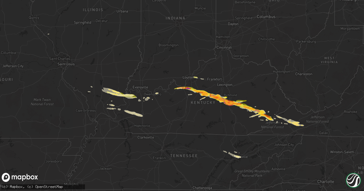
Hail Map in Kentucky on April 25, 2015
Get this storm
April 25 map
$229
one time, instant access
Download today. No call, no setup
Keep the $229
Bought the map and want the full workflow? Apply the entire $229 to a subscription within 7 days. None of it is wasted.
Every map, not just this one
This buys you this map. Subscription and you get every map we run, in the markets you choose from a few cities to whole states to nationwide. Plus real-time alerts the moment a storm fires.
Contact data
Name, contact info, occupancy, even credit band for addresses in the footprint. You go from where it hit to who to call.
Become the source they trust
Unlimited branding weather history reports on demand. You already have the documented answer ready for the property owner, and you are the one who showed up with it.
Property data and RoofTrace estimates
Pull up any address you have got, its value and the exact code rules for that jurisdiction, straight from One Click Code. Then RoofTrace estimates the squares, pitch, and roof value, priced the way you price.
Storm reports in Kentucky
Kentucky
| Date | Description |
|---|---|
| 04/25/20156:46 PM CDT | A local report indicates 1.00 inch wind near JEFFERSONTOWN |
| 04/25/20156:45 PM CDT | This is a public report via twitter. |
| 04/25/20156:45 PM CDT | A local report indicates 2.50 inch wind near SPRINGFIELD |
| 04/25/20156:30 PM CDT | A local report indicates 1.00 inch wind near 5 NW DAWSON SPRINGS |
| 04/25/20156:30 PM CDT | A local report indicates 1.25 inch wind near 4 W MAUD |
| 04/25/20156:30 PM CDT | A local report indicates 75 MPH wind near 5 NW DAWSON SPRINGS |
| 04/25/20156:23 PM CDT | Delayed report. |
| 04/25/20156:18 PM CDT | A local report indicates 1.00 inch wind near 2 E NAZARETH |
| 04/25/20156:12 PM CDT | 60 to 65 mph wind gusts and pea size hail |
| 04/25/20155:58 PM CDT | A local report indicates 1.50 inch wind near 4 NNE SAINT CATHERINE |
| 04/25/20155:38 PM CDT | A local report indicates 1.00 inch wind near BRANDENBURG |
| 04/25/20155:30 PM CDT | A local report indicates 1.00 inch wind near BRANDENBURG |
| 04/25/20155:24 PM CDT | Ef-0 tornado with peak wind 85 mph. Path length 3/4 mile. Path width 275 yards. At least a half dozen trees uprooted. Damage to carport and rv due to fallen trees. Part |
| 04/25/20155:22 PM CDT | Mobile home destroyed. |
| 04/25/20155:20 PM CDT | *** 1 inj *** peak wind est 100 mph. Thunderstorm wind event began approx. 3 sw smith mills ky at 520 pm cdt and extended for 16 miles to its termination 2 ne robards k |
| 04/25/20155:09 PM CDT | Quarter size hail reported |
| 04/25/20155:09 PM CDT | Quarter size hail reported. |
| 04/24/201510:15 PM CDT | A local report indicates 1.50 inch wind near 1 W PARTRIDGE |
| 04/24/20159:48 PM CDT | Trees and powerlines down in hemlock subdivision. |
| 04/24/20159:48 PM CDT | Trees and powerlines down on angel road. |
| 04/24/20159:47 PM CDT | A local report indicates 1.75 inch wind near VIPER |
| 04/24/20159:40 PM CDT | Damage to siding of a home...outbuilding moved about a foot...with some trees damaged and uprooted along craig road. |
| 04/24/20159:24 PM CDT | A local report indicates 1.00 inch wind near WHITESBURG |
| 04/24/20159:15 PM CDT | This is a public report via twitter. |
| 04/24/20159:10 PM CDT | Porch and deck destroyed by fallen trees. |
| 04/24/20159:04 PM CDT | Trees down across the county |
| 04/24/20158:55 PM CDT | A local report indicates 1.50 inch wind near DONGOLA |
| 04/24/20158:45 PM CDT | A local report indicates 1.25 inch wind near 3 NNW AVAWAM |
| 04/24/20158:43 PM CDT | A local report indicates 61 MPH wind near 1 WNW JAMESTOWN |
| 04/24/20158:40 PM CDT | Downed tree blocking hwy 55 |
| 04/24/20158:38 PM CDT | Trees...power lines and power poles down on old montpelier road. Roof damage to several homes. Barns pushed over and silos knocked down. |
| 04/24/20158:37 PM CDT | A local report indicates 1.00 inch wind near KRYPTON |
| 04/24/20158:30 PM CDT | A local report indicates 1.00 inch wind near WHITESBURG |
| 04/24/20158:29 PM CDT | The tornado first touched down 6 miles southeast of columbia along dale morrison road. Numerous trees were uprooted and a 145-foot barn was destroyed... With the top shea (lm |
| 04/24/20158:25 PM CDT | One tree reported down. |
| 04/24/20158:25 PM CDT | A local report indicates 1.75 inch wind near 1 SW BUCKHORN |
| 04/24/20158:10 PM CDT | A local report indicates 1.25 inch wind near 1 SW RICETOWN |
| 04/24/20158:05 PM CDT | A local report indicates 1.00 inch wind near ISLAND CITY |
| 04/24/20158:00 PM CDT | A local report indicates 1.00 inch wind near 2 NW ISLAND CITY |
| 04/24/20157:40 PM CDT | A local report indicates 1.25 inch wind near MCKEE |
| 04/24/20157:35 PM CDT | A local report indicates 1.00 inch wind near 2 NW BEATTYVILLE |
| 04/24/20157:35 PM CDT | A local report indicates 1.75 inch wind near LANCASTER |
| 04/24/20157:32 PM CDT | A local report indicates 60 MPH wind near BROWNSVILLE |
| 04/24/20157:28 PM CDT | A local report indicates 1.75 inch wind near CLOVER BOTTOM |
| 04/24/20157:27 PM CDT | A local report indicates 2.00 inch wind near 1 E NEVADA |
| 04/24/20157:25 PM CDT | Several trees downed in mammoth cave national park... With the largest along houchins ferry rd north of the green river. Measuring instrument 5 miles southeast of this re (lm |
| 04/24/20157:21 PM CDT | 15 to 20 trees down. |
| 04/24/20157:19 PM CDT | A local report indicates 1.00 inch wind near DANVILLE |
| 04/24/20157:18 PM CDT | This is a public report via twitter. |
| 04/24/20157:16 PM CDT | A local report indicates 3.00 inch wind near DANVILLE |
| 04/24/20157:15 PM CDT | A local report indicates 2.50 inch wind near 2 N DANVILLE |
| 04/24/20157:15 PM CDT | This is a public report via twitter. |
| 04/24/20157:12 PM CDT | Private weather station in huff... Ky. |
| 04/24/20157:12 PM CDT | Hail just smaller than tennis ball in scaffold cane. Relayed via twitter. |
| 04/24/20157:12 PM CDT | This is a public report via twitter. |
| 04/24/20157:12 PM CDT | A local report indicates a tornado near 3 NNW WINDYVILLE |
| 04/24/20157:11 PM CDT | Trained spotter reported hail was at least golf ball sized. |
| 04/24/20157:11 PM CDT | A local report indicates 1.75 inch wind near BEREA |
| 04/24/20157:10 PM CDT | Delayed report. Nws survey team found straight line wind damage. Large limbs broken. Metal roof from barn blown off. |
| 04/24/20157:09 PM CDT | Pea size hail and heavy rainfall associated with this storm. |
| 04/24/20157:09 PM CDT | Pea size hail and heavy rainfall associated with this storm. Report along hwy 853. |
| 04/24/20157:08 PM CDT | A local report indicates 1.50 inch wind near 2 E BEREA |
| 04/24/20157:07 PM CDT | Corrected for the time. |
| 04/24/20157:07 PM CDT | A local report indicates 1.00 inch wind near 2 W SHELBYVILLE |
All States Impacted by Hail Map on April 25, 2015
Cities Impacted by Hail Map on April 25, 2015
- Linefork, KY
- Hallie, KY
- Greenville, FL
- Diamondhead, MS
- Waveland, MS
- Bay Saint Louis, MS
- Bryceville, FL
- Jacksonville, FL
- Lake City, FL
- White Springs, FL
- Jasper, FL
- Knoxville, TN
- Fort Gaines, GA
- Eufaula, AL
- Abbeville, AL
- Georgetown, GA
- Morris, GA
- Oelrichs, SD
- Chadron, NE
- Fairhope, AL
- Coal City, WV
- Princewick, WV
- McKee, KY
- Mount Vernon, KY
- Lancaster, KY
- Harrodsburg, KY
- Sandgap, KY
- Danville, KY
- Perryville, KY
- Stanford, KY
- Paint Lick, KY
- Berea, KY
- Brodhead, KY
- Crab Orchard, KY
- Lisco, NE
- Cochran, GA
- Dry Branch, GA
- Moss Point, MS
- Gautier, MS
- Bardstown, KY
- Bloomfield, KY
- Springfield, KY
- Willisburg, KY
- Dudley, GA
- Dublin, GA
- Rentz, GA
- Dexter, GA
- Equality, IL
- Raleigh, IL
- Ridgway, IL
- Eldorado, IL
- Sebree, KY
- Robards, KY
- Partridge, KY
- Whitesburg, KY
- Ocean Springs, MS
- Pascagoula, MS
- Milledgeville, GA
- Sparta, GA
- Hilton Head Island, SC
- Bluffton, SC
- Clio, AL
- Louisville, AL
- Clayton, AL
- Sweeny, TX
- Van Vleck, TX
- Coden, AL
- Bayou La Batre, AL
- Theodore, AL
- Irvington, AL
- Edna, TX
- East Dublin, GA
- Utica, KY
- Calhoun, KY
- Owensboro, KY
- Ponchatoula, LA
- Saint Amant, LA
- Maurepas, LA
- Springfield, LA
- Metter, GA
- Claxton, GA
- Register, GA
- Wooton, KY
- Fort Knox, KY
- Happy, KY
- Letcher, KY
- Mackville, KY
- Tyner, KY
- Sassafras, KY
- Busy, KY
- Burgin, KY
- Bonnyman, KY
- Eolia, KY
- Gays Creek, KY
- Buckhorn, KY
- Thousandsticks, KY
- Shepherdsville, KY
- Guston, KY
- Mistletoe, KY
- Vincent, KY
- Scuddy, KY
- Smilax, KY
- Viper, KY
- Boston, KY
- Vicco, KY
- Richmond, KY
- Chavies, KY
- Ekron, KY
- Coxs Creek, KY
- Bulan, KY
- Clermont, KY
- Ricetown, KY
- West Point, KY
- Combs, KY
- Cornettsville, KY
- Brandenburg, KY
- Lebanon Junction, KY
- Oneida, KY
- Hazard, KY
- Orlando, KY
- Irvine, KY
- Muldraugh, KY
- Krypton, KY
- Blackey, KY
- Roxana, KY
- Jeff, KY
- Booneville, KY
- Appalachia, VA
- Laconia, IN
- Big Creek, KY
- Hyden, KY
- Pembroke, GA
- Wise, VA
- Norton, VA
- Loretto, KY
- Lebanon, KY
- Bell City, LA
- Lake Arthur, LA
- Lacassine, LA
- Cameron, LA
- Iowa, LA
- Lake Charles, LA
- Welsh, LA
- Mauk, GA
- Junction City, GA
- Fort Valley, GA
- Reynolds, GA
- Butler, GA
- Simpsonville, KY
- Shelbyville, KY
- Blessing, TX
- Louise, TX
- Midfield, TX
- Bay City, TX
- Markham, TX
- Ellabell, GA
- Hitchcock, TX
- Knoxville, GA
- Macon, GA
- Byron, GA
- Roberta, GA
- Lizella, GA
- Cleveland, VA
- Honaker, VA
- Galatia, IL
- Pledger, TX
- Boling, TX
- Wharton, TX
- West Columbia, TX
- El Campo, TX
- Damon, TX
- Banks, AL
- Troy, AL
- Midway, AL
- Brenton, WV
- Pineville, WV
- Harrison, NE
- Chester, GA
- Danville, GA
- Swainsboro, GA
- Perry, GA
- Warner Robins, GA
- Bonaire, GA
- Lyons, GA
- Rockledge, GA
- Tarrytown, GA
- Soperton, GA
- Cobbtown, GA
- Kathleen, GA
- Montrose, GA
- Box Springs, GA
- Collins, GA
- Marshallville, GA
- Talbotton, GA
- Vidalia, GA
- Jeffersonville, GA
- Daphne, AL
- Silverhill, AL
- Loxley, AL
- Lebanon, VA
- Rosedale, VA
- Saltville, VA
- Little River, AL
- Jackson, AL
- Macedonia, IL
- Uniontown, KY
- Harrisburg, IL
- Junction, IL
- Omaha, IL
- Thompsonville, IL
- Morganfield, KY
- Shawneetown, IL
- Waverly, KY
- Louisville, KY
- Lolita, TX
- Grand Bay, AL
- Glen Fork, WV
- Cedar Bluff, VA
- Sidney, NE
- Lodgepole, NE
- Kaplan, LA
- Hardeeville, SC
- Golconda, IL
- Eddyville, IL
- Simpson, IL
- Cuthbert, GA
- Shellman, GA
- Fredonia, KY
- Princeton, KY
- Nortonville, KY
- Crofton, KY
- Dawson Springs, KY
- Saint Charles, KY
- Marion, KY
- North Spring, WV
- Iaeger, WV
- Hanover, WV
- La Marque, TX
- Texas City, TX
- Galveston, TX
- Leesburg, GA
- Slidell, LA
- Minter, AL
- Egan, LA
- Morse, LA
- Meadowview, VA
- Peetz, CO
- Mandeville, LA
- Pearlington, MS
- Pass Christian, MS
- Lee, FL
- Macclenny, FL
- Saint George, GA
- Hampton, KY
- Salem, KY
- Burna, KY
- Iliff, CO
- Crook, CO
- Fitzgerald, GA
- Clintwood, VA
- Coeburn, VA
- Marion, VA
- McClure, VA
- Dante, VA
- Nora, VA
- Clinchco, VA
- Davenport, VA
- Castlewood, VA
- Pound, VA
- Glade Spring, VA
- Cordele, GA
- De Soto, GA
- Leslie, GA
- Jackson, KY
- Whick, KY
- Milton, FL
- Irvington, KY
- Rayne, LA
- Crowley, LA
- Crandall, IN
- Georgetown, IN
- Corydon, IN
- Richmond, TX
- Needville, TX
- Abbeville, LA
- White Castle, LA
- Slab Fork, WV
- Rhodell, WV
- Lost Creek, KY
- Iota, LA
- Branch, LA
- Lacombe, LA
- Pearl River, LA
- Uriah, AL
- Brush, CO
- Manchester, KY
- Angleton, TX
- Boston, GA
- Maceo, KY
- Philpot, KY
- Lewisport, KY
- Missouri City, TX
- Rosharon, TX
- La Place, LA
- Shorterville, AL
- Leakesville, MS
- Vernon, FL
- Chipley, FL
- Santa Fe, TX
- Port Bolivar, TX
- Oakfield, GA
- Pensacola, FL
- Ashburn, GA
- Smithland, KY
- McIntosh, AL
- Glen Saint Mary, FL
- Sanderson, FL
- Vinegar Bend, AL
- Sedgwick, CO
- Fleming, CO
- Hay Springs, NE
- Rushville, NE
- Shady Spring, WV
- Cool Ridge, WV
- Clopton, AL
- Hurtsboro, AL
- Union Springs, AL
- Hatchechubbee, AL
- Pittsview, AL
- Brundidge, AL
- Saint Gabriel, LA
- Geismar, LA
- Donaldsonville, LA
- Carville, LA
- Billingsley, AL
- Pleasant Hill, IL
- Holt, FL
- Baker, FL
- Clinton, TN
- Powell, TN
- Heiskell, TN
- Cumberland, KY
- Murphysboro, IL
- Ava, IL
- Smithville, GA
- Crestview, FL
- Ganado, TX
- Arabi, GA
- Albany, GA
- Dawson, GA
- Bronwood, GA
- Atmore, AL
- Bay Minette, AL
- Perdido, AL
- Richland, GA
- Lumpkin, GA
- Pitts, GA
- Mobile, AL
- Vancleave, MS
- Jennings, FL
- Port Wentworth, GA
- Long Beach, MS
- Plaquemine, LA
- Deer Park, AL
- Neely, MS
- Atlanta, LA
- Dry Prong, LA
- Colfax, LA
- Brantley, AL
- Luverne, AL
- Gonzales, LA
- Hemphill, TX
- Carriere, MS
- Picayune, MS
- Rincon, GA
- Grantsburg, IL
- Brazoria, TX
- Saulsville, WV
- Simon, WV
- Ikes Fork, WV
- Davy, WV
- Stonefort, IL
- Irwinton, GA
- Ponce De Leon, FL
- Caryville, FL
- Delphia, KY
- Slemp, KY
- Yeaddiss, KY
- Gordon, KY
- Eight Mile, AL
- Montevallo, AL
- Seale, AL
- Littcarr, KY
- Mallie, KY
- Pine Top, KY
- Oliver Springs, TN
- Wartburg, TN
- Robertsdale, AL
- Stennis Space Center, MS
- Mermentau, LA
- Evangeline, LA
- Jennings, LA
- Estherwood, LA
- Alvin, TX
- Liverpool, TX
- Jenkins, KY
- Beasley, TX
- Oak Ridge, TN
- McRae Helena, GA
- Broughton, IL
- Johnston City, IL
- Corydon, KY
- Sturgis, KY
- West Frankfort, IL
- Benton, IL
- Pittsburg, IL
- Marion, IL
- Ellsworth, NE
- Americus, GA
- Du Quoin, IL
- Freeport, TX
- Saint Paul, VA
- Thomasville, GA
- Samson, AL
- Padroni, CO
- Coleman, GA
- Live Oak, FL
- Elizabethtown, KY
- Mayking, KY
- Premium, KY
- Beattyville, KY
- Jeremiah, KY
- Webster, KY


