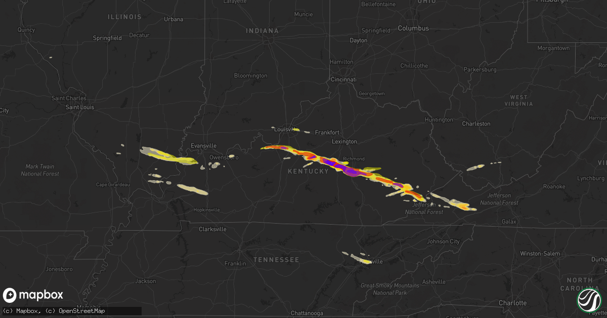
Hail Map on April 25, 2015
Get this storm
April 25 map
$229
one time, instant access
Download today. No call, no setup
Keep the $229
Bought the map and want the full workflow? Apply the entire $229 to a subscription within 7 days. None of it is wasted.
Every map, not just this one
This buys you this map. Subscription and you get every map we run, in the markets you choose from a few cities to whole states to nationwide. Plus real-time alerts the moment a storm fires.
Contact data
Name, contact info, occupancy, even credit band for addresses in the footprint. You go from where it hit to who to call.
Become the source they trust
Unlimited branding weather history reports on demand. You already have the documented answer ready for the property owner, and you are the one who showed up with it.
Property data and RoofTrace estimates
Pull up any address you have got, its value and the exact code rules for that jurisdiction, straight from One Click Code. Then RoofTrace estimates the squares, pitch, and roof value, priced the way you price.
States Impacted by Hail Map on April 25, 2015
Storm reports
Florida
| Date | Description |
|---|---|
| 04/25/20155:06 PM CDT | Part of gas station awning torn off. Numerous large trees down. |
| 04/25/20155:05 PM CDT | Estimated 70 mph wind gust along hodges blvd north of butler blvd. Numerous large tree limbs down. |
| 04/25/20155:03 PM CDT | Numerous trees down. Patio roof ripped off in southside jacksonville. |
| 04/25/20155:00 PM CDT | Couple of trees down near caryville |
| 04/25/20155:00 PM CDT | In the area around king lake road...pittman road...and paxton...there are 5 large oak trees down...1 pecan tree down...and 4 power poles snapped. Time estimated. |
| 04/25/20154:57 PM CDT | Media reporting trees and transformers down near san jose blvd. And emerson. |
| 04/25/20154:52 PM CDT | An ef-1 tornado with maximum winds of 104 mph and a path width of 300 yards developed along the eastern shore of the st. Johns river and moved ese through the southside |
| 04/25/20154:46 PM CDT | Trees downed blocking south bound traffic on hwy 331 near pittman road. |
| 04/25/20154:46 PM CDT | Trees down and quarter size hail reported on normandy blvd. |
| 04/25/20154:42 PM CDT | Large tree down on pipers landing road at kings lake blvd. |
| 04/25/20154:24 PM CDT | Tree down on cr 250. |
| 04/25/20154:24 PM CDT | Carport blown on to power lines on frenda rd. |
| 04/25/20154:24 PM CDT | Tree down on bob burnsed road. |
| 04/25/20154:24 PM CDT | Tree down on power line at deer creek lane and cr23a. |
| 04/25/20154:13 PM CDT | Asos a whiting field naval air station recorded a wind gust of 58mph. |
| 04/25/20154:05 PM CDT | Pensacola asos recorded a 61mph wind gust. |
| 04/25/201511:40 AM CDT | Delayed report from april 25th storm of 10 to 15 trees down laying in a ditch off of i-10 in eastern madison county |
| 04/25/20158:20 AM CDT | Tree down on basswood road around a mile away from hwy 71 north. |
| 04/25/20157:58 AM CDT | Trees down on hwy 77 s of the interstate at peel rd and at orange hill rd and hays lane. |
| 04/25/20157:17 AM CDT | Power lines down on road in de funiak springs with traffic being re-routed. Relayed by wmbb-tv meteorologist. |
Louisiana
| Date | Description |
|---|---|
| 04/25/20151:58 PM CDT | Tree down on east judge perez between center and alexander streets in arabi |
| 04/25/20151:30 PM CDT | Trees and power lines down in westwego and marrero. |
| 04/25/20151:19 PM CDT | Cleco outage map indicating outages in old mandeville along lakeshore drive and along rapatel street. Estimated about 425 customers without power. |
| 04/25/201512:41 PM CDT | Near causeway blvd. Bridge closed due to hail and high winds on north end of span. |
| 04/25/201512:38 PM CDT | Numerous large tree limbs... Fencing down. Power outage in old mandeville area. Wst electric estimating 400 customers without power. |
| 04/25/201512:34 PM CDT | Weatherflow observation at foot of sunset point pier measured 236/50.3kt with a temperature drop from 78f to 71f and pressure v of 3 mb in 10 minutes. |
| 04/25/201511:33 AM CDT | Public reports tree down along charlie field rd |
| 04/25/201510:38 AM CDT | Law enforcement reports tree blocking highway 103 near high school |
| 04/25/201510:10 AM CDT | A local report indicates 1.00 inch wind near HAYES |
West Virginia
| Date | Description |
|---|---|
| 04/24/20159:25 PM CDT | A local report indicates 1.25 inch wind near COAL CITY |
| 04/24/20158:55 PM CDT | Quarter sized hail in rock view. Via social media. |
| 04/24/20158:45 PM CDT | Half dollar sized hail near jesse. Via social media. |
South Carolina
| Date | Description |
|---|---|
| 04/24/20158:14 PM CDT | Jasper county 911 reported multiple trees down in area near cook landing rd and bellinger hill rd. |
Tennessee
| Date | Description |
|---|---|
| 04/25/20151:25 AM CDT | Several trees down... Some power lines down and structural damage |
| 04/25/201512:02 AM CDT | A local report indicates 1.00 inch wind near 3 ESE BAILEYTON |
| 04/24/201511:40 PM CDT | Trees down along little river road and in the metcalf bottoms area of great smoky mountains national park. |
| 04/24/201511:35 PM CDT | A few trees down on the foothills parkway in the townsend area. |
| 04/24/201511:15 PM CDT | Few trees down. |
| 04/24/201511:00 PM CDT | Near intersection of 640 and broadway. |
Nevada
| Date | Description |
|---|---|
| 04/25/20156:25 PM CDT | Windows knocked out of the nugget casino and satellite dish knocked down at kpvm-tv. Also a power outage impacting the south end of town. |
| 04/25/20156:25 PM CDT | Public report of a large tree snapped down in pahrump through a pahrump tv station facebook page. |
| 04/25/20152:27 PM CDT | A line of thunderstorms moved through producing a gust to 59 mph. |
Alabama
| Date | Description |
|---|---|
| 04/25/20155:55 PM CDT | Social media report of numerous trees and power lines down in columbia |
| 04/25/20155:50 PM CDT | Numerous trees down around the webb area along highway 52. Trees snapped 6 to 8 feet up |
| 04/25/20155:50 PM CDT | Social media report of trees down on ludlam road |
| 04/25/20155:48 PM CDT | Trees down on county road 55 |
| 04/25/20155:48 PM CDT | Trees down on county road 49 |
| 04/25/20155:48 PM CDT | Trees down on county road 6 |
| 04/25/20155:48 PM CDT | Trees down on highway 10 east |
| 04/25/20155:47 PM CDT | Large tree and power lines across prevatt road in ashford. Public report to wtvy-tv facebook page. |
| 04/25/20155:47 PM CDT | Gas station awning damaged along old us 84. Report and picture via wdhn-tv. |
| 04/25/20155:45 PM CDT | Multiple trees blown down in the headland area. Wooden swing set blown into a fence. Public post to wtvy-tv facebook page. |
| 04/25/20155:45 PM CDT | Multiple trees and power lines down around cowarts. Public report to wtvy-tv facebook page. |
| 04/25/20155:42 PM CDT | Large tree downed...report and damage picture via social media. Time estimated from radar. |
| 04/25/20155:42 PM CDT | Large oak tree snapped in kinsey. Picture posted to wtvy-tv facebook page. |
| 04/25/20155:41 PM CDT | Large pine tree snappped and fell into aberdeen road. Picture via wdhn-tv facebook. |
| 04/25/20155:40 PM CDT | Social media report of a large tree on a house on church street with a car demolished |
| 04/25/20155:40 PM CDT | Numerous additional reports of trees and power lines down across dothan...with some damage to a few carports or outbuildings...and some houses and cars due to falling t |
| 04/25/20155:40 PM CDT | Two trees down and a power pole down on tate drive near rip hewes stadium in dothan. Public report to the wtvy-tv facebook page. |
| 04/25/20155:39 PM CDT | Large awning blown into the median of ross tucker circle from a nearby structure. Picture via wdhn-tv facebook. |
| 04/25/20155:39 PM CDT | Large tree down across timbers drive southwest of dothan. Per public picture post to wdhn-tv facebook. |
| 04/25/20155:38 PM CDT | Multiple trees snapped and uprooted in the rehobeth area. Pictures posted to wtvy-tv facebook. |
| 04/25/20155:35 PM CDT | 59 mph wind gust measured at the dothan airport asos. |
| 04/25/20155:30 PM CDT | Tree down on a fence on wicksburg road by allen stagefield |
| 04/25/20155:30 PM CDT | Large tree snapped in slocomb. Report to the wtvy-tv facebook page. |
| 04/25/20155:25 PM CDT | Numerous trees and power lines down in dale county |
| 04/25/20155:25 PM CDT | Social media report of several trees down on homes in hartford |
| 04/25/20155:23 PM CDT | Mobile home trailer blown onto its side between hartford and wicksburg. Reported by wdhn reporter. |
| 04/25/20155:18 PM CDT | Barn destroyed on county rd 35 |
| 04/25/20155:15 PM CDT | Numerous trees down around geneva county and the city of geneva...reported by county em. Wdhn-tv also posted photos of several large trees down in the city of geneva an |
| 04/25/20155:15 PM CDT | Tree down on highway 27 between enterprise and ozark. Public report to wtvy-tv facebook page. |
| 04/25/20155:15 PM CDT | Measured 58.25 mph gust at a university of south alabama mesonet site in geneva. |
| 04/25/20155:15 PM CDT | Tree down. |
| 04/25/20155:15 PM CDT | Tree down on highway 27 north. |
| 04/25/20155:10 PM CDT | Numerous trees and power lines down |
| 04/25/20155:05 PM CDT | Social media report and picture of a tree down on a pickup near hacoda |
| 04/25/20154:44 PM CDT | Two to three dozen trees down in the seale area with some minor damage to outbuildings as well. The main damage was concentrated to the dudley loop and bush rd intersec |
| 04/25/20154:35 PM CDT | Asos at andalusia airforce base recorded a 61mph wind gust. |
| 04/25/20154:05 PM CDT | One tree down and some large limbs down along highways 97 and 37. Time estimated from radar. Winds estimated 40 to 50 mph. Corrected report. |
| 04/25/20154:05 PM CDT | Single tree down in two locations in midway |
| 04/25/20153:40 PM CDT | Trained spotter reports trees down and structural damagage to houses in the rosinton area. |
| 04/25/20153:35 PM CDT | Off duty nws employee estimates 60mph winds. Time estimated from radar. |
| 04/25/20153:31 PM CDT | Large 40-50 foot tall large diameter trees reported down in the silver hill community. Time estimated via radar. |
| 04/25/20153:24 PM CDT | Multiple trees down along wood acres rd. |
| 04/25/20153:20 PM CDT | South alabama mesonet in fairhope recorded a 58mph wind gust associated with severe storms. |
| 04/25/20153:07 PM CDT | Tree down in roadway on bear fork rd near moffett rd. Report relayed via social media. |
| 04/25/20153:07 PM CDT | Large tree felled on the campus of the university of south alabama. Report relayed via social media. |
| 04/25/20153:07 PM CDT | Public reports a large tree down on grand bay wilmer rd near sams super burger. Report relayed via social media. |
| 04/25/20153:05 PM CDT | Large trees down near the town of excel. Time estimated from radar. |
| 04/25/20153:00 PM CDT | Large tree down...broken at trunk at grand bay-wilmer and interstate 10. |
| 04/25/20152:59 PM CDT | Power lines down on wilmer rd near tanner williams rd. Report relayed via social media. |
| 04/25/20152:56 PM CDT | Public reports power lines down along mccrary rd between spice pond and lott roads. Report relayed via social media. |
| 04/25/20151:52 PM CDT | Large tree down across hwy 45 north of deer park. Time estimated from radar. |
Mississippi
| Date | Description |
|---|---|
| 04/25/20152:51 PM CDT | Reported from north market street |
| 04/25/20152:37 PM CDT | Several trees and power lines down in the south-central part of the county generally south of u.s. 90 and south of highway 57. |
| 04/25/20152:33 PM CDT | Spotter 19113 reported high winds...limbs...trash cans and yard debris blown around. |
| 04/25/20151:58 PM CDT | Also power outages reported |
| 04/25/20151:50 PM CDT | County ema cites multiple reports of large trees down in greene county... Ms. Time estimated via radar |
| 04/25/20151:36 PM CDT | Several large trees down and one house damaged. |
| 04/25/20151:20 PM CDT | Numerous trees and power lines down throughout much of the county and within the incorporated areas. Some urban street flooding within the coastal cities at time of hea |
Georgia
| Date | Description |
|---|---|
| 04/25/20156:57 PM CDT | Numerous trees were blown down countywide. Some were blown onto roads. |
| 04/25/20156:56 PM CDT | Tree down across donnell rd. Time estimated from radar |
| 04/25/20156:55 PM CDT | Spotter estimated wind gusts near 60 mph near highway 270 and highway 33 |
| 04/25/20156:52 PM CDT | Strong winds blew down large tree limbs which damaged a metal fence on gander lane. Public post to walb-tv facebook page. |
| 04/25/20156:52 PM CDT | Numerous trees and power lines down across the county |
| 04/25/20156:50 PM CDT | Large tree snapped along green street near the train tracks in doerun. |
| 04/25/20156:48 PM CDT | Tree and power line down in sumner |
| 04/25/20156:47 PM CDT | Tree down in the eastern part of mitchell county close to the border with colquitt county |
| 04/25/20156:30 PM CDT | Several trees down around ashburn |
| 04/25/20156:30 PM CDT | Several trees and power lines down around baker county |
| 04/25/20156:22 PM CDT | Em reported numerous trees down south of dublin south of i-16. |
| 04/25/20156:17 PM CDT | Several trees and power lines down around miller county |
| 04/25/20156:15 PM CDT | Couple of trees down around albany |
| 04/25/20156:12 PM CDT | Numerous trees were blown down countywide. Some were blown onto roads. |
| 04/25/20156:11 PM CDT | Emergency manager reports numerous trees and powerlines down across the county. At least one tree is on a house. |
| 04/25/20156:08 PM CDT | Numerous trees and power lines down across early county |
| 04/25/20156:07 PM CDT | Tree down in oakfield |
| 04/25/20156:02 PM CDT | A large tree was snapped near its base on east bob white road in kathleen. |
| 04/25/20155:57 PM CDT | Several trees were blown down in the lake joy and houston lake area. |
| 04/25/20155:55 PM CDT | Several trees and power lines down in the county with some trees uprooted. Also roof off a county building in downtown. |
| 04/25/20155:52 PM CDT | Strong winds blew down large tree limbs which damaged a metal fence on gander lane. Public post to walb-tv facebook page. |
| 04/25/20155:50 PM CDT | Trees and power lines down in clay county |
| 04/25/20155:50 PM CDT | 911 reports trees down trhoughout the county with the greatest concentration just north of leslie. |
| 04/25/20155:47 PM CDT | 20-30 pecan trees uprooted near valley view drive and state hwy 96 in fort valley. Power lines were also down in the area and there was a report of light standards blow |
| 04/25/20155:42 PM CDT | Baseball sized hail fell on academy avenue extension in dublin. Photo relayed on social media. |
| 04/25/20155:40 PM CDT | Power line down along sellers road |
| 04/25/20155:36 PM CDT | Tree down on highway 257 near west laurens high school. |
| 04/25/20155:35 PM CDT | Trees down around dawson |
| 04/25/20155:33 PM CDT | Photo of golfball sized hail on social media. |
| 04/25/20155:31 PM CDT | Social media picture of several golf ball sized hail stones on hartley bridge rd. |
| 04/25/20155:25 PM CDT | Golf ball sized hail was falling on richardson mill road. |
| 04/25/20155:25 PM CDT | Tree down across a road in shellman |
| 04/25/20155:19 PM CDT | A large tree fell on a shed on ed davis rd. |
| 04/25/20155:12 PM CDT | A large tree was blown down in fort valley. Photo from social media. |
| 04/25/20155:12 PM CDT | Quarter size hail reported by fire dept in montrose. |
| 04/25/20155:08 PM CDT | A tree was blown down onto powerlines on buena vista rd near holly hills. |
| 04/25/20155:07 PM CDT | A large tree was uprooted on charles drive in fort valley. |
| 04/25/20155:05 PM CDT | Trees and power lines down. |
| 04/25/20154:55 PM CDT | Quarter size hail in pataula creek between ft. Gaines and georgetown. Public report to wtvy-tv facebook. |
| 04/25/20154:45 PM CDT | A tree was blown down on lake joy road. |
| 04/25/20154:45 PM CDT | Trees and power lines down in quitman county |
| 04/25/20154:35 PM CDT | 911 center reports numerous trees and powerlines down throughout the county with greatest concentration near butler. |
| 04/25/20159:27 AM CDT | 35 to 40 trees down county wide. Time estimated from radar. |
| 04/25/20158:36 AM CDT | Several large oak trees were brought down along with an additional number of pines along interstate 16...near mm 58 - hwy 199. Time estimated from radar. Follow-up repo |
| 04/24/20159:12 PM CDT | Tree down at intersection of swamp rd and ga hwy 99 |
| 04/24/20159:06 PM CDT | Tree down across johnson rd near ga hwy 99 |
| 04/24/20158:31 PM CDT | Tybee north weatherflow sensor |
| 04/24/20158:25 PM CDT | South tybee island weatherflow sensor |
| 04/24/20158:24 PM CDT | Tree down on tibet rd |
| 04/24/20158:22 PM CDT | Roof damaged at a nursing home in midway. Evacuations were necessary. Time estimated based on radar. |
| 04/24/20158:19 PM CDT | Trees down on limerick road. Time estimated based on radar. |
| 04/24/20158:15 PM CDT | A tree was blown down on wilmington island along north cromwell road. Time was estimated from radar data. |
| 04/24/20158:15 PM CDT | Wayne county 911/dispatch reports numerous trees and powerlines down county-wide. |
| 04/24/20158:09 PM CDT | Tree down on house. Report via facebook |
| 04/24/20158:08 PM CDT | Trees were blown down at scattered locations along skidaway road between virginia avenue and 41st street. Time was estimated from radar data. |
| 04/24/20158:06 PM CDT | Large gas station awning covering gas pumps blown down on waters avenue. Time estimated based on radar. |
| 04/24/20158:05 PM CDT | A tree was blown onto power lines at the intersection of bull street and thackery place. Time was estimated from radar data. |
| 04/24/20158:04 PM CDT | *** 1 inj *** tree fell down on a house on west street causing one injury to a female. |
| 04/24/20158:03 PM CDT | Trees were blown down at scattered locations along ogeechee road between 37th street and corvair street. Time was estimated from radar data. |
| 04/24/20158:03 PM CDT | Thunderstorm winds blew a tree onto a vehicle at the intersection of ogeechee road and kollock street. Time was estimated from radar data. |
| 04/24/20158:02 PM CDT | Multiple trees were blown down in the garden city vicinity. Time was estimated radar data. |
| 04/24/20158:01 PM CDT | Two trees were blown down along state route 21 between gulfstream road and grange road. Time was estimated from radar data. |
| 04/24/20158:01 PM CDT | Multiple trees were blown down in the port wentworth vicinity. Time was estimated from radar data. |
| 04/24/20158:01 PM CDT | A peak wind gust of 91 mph was observed on an elevated crane at the georgia ports authority. |
| 04/24/20158:01 PM CDT | Shipping crane tipped over at the georgia ports authority. |
| 04/24/20158:00 PM CDT | Ksav reported peak wind of 70 kt....81 mph |
| 04/24/20158:00 PM CDT | Multiple trees and powerlines down on coleraine dr |
| 04/24/20158:00 PM CDT | Multiple trees down on wyndham rd in the forest lakes subdivision |
| 04/24/20158:00 PM CDT | Trees were blown down onto interstate 95 between mile markers 106 and 109. Time was estimated from radar data. |
| 04/24/20158:00 PM CDT | Several aircraft were damaged by thunderstorm winds in the general aviation section of savannah airport. A wind gust to 81 mph was measured at the airport. |
| 04/24/20158:00 PM CDT | Multiple trees down...some newly planted...in new tangier outlet parking lot. At least one tree on car |
| 04/24/20158:00 PM CDT | Multiple trees down on houses and power lines near cliff dr in pooler |
| 04/24/20157:59 PM CDT | Tree down blocking northbound lanes of interstate 95 near ga tech campus |
| 04/24/20157:52 PM CDT | Trees were blown down at scattered locations along bloomingdale road between the interstate 16 interchange and pine barren road. Time was estimated from radar data. |
| 04/24/20157:50 PM CDT | Trees were reported down on boxankle rd |
| 04/24/20157:48 PM CDT | Large distribution power lines blown down. Multiple large trees down on highway 30 and noel conaway road near buckingham drive. |
| 04/24/20157:48 PM CDT | Numerous trees down on power lines and across roads around eden |
| 04/24/20157:48 PM CDT | Trees and debris in road at zeigler road and kathy street. Time estimated based on radar. |
| 04/24/20157:47 PM CDT | Tree down on highway 119 near the bulloch county border. |
| 04/24/20157:45 PM CDT | Power lines down at highway 17 south and blue jay road. Time estimated based on radar. |
| 04/24/20157:45 PM CDT | Trees and power lines down near the intersection of roebling rd and rt 17 |
| 04/24/20157:45 PM CDT | Large trees blown down in a neighborhood off old oak road. |
| 04/24/20157:45 PM CDT | Large trees blown down in a neighborhood off brittany lane. |
| 04/24/20157:43 PM CDT | Multiple trees and power lines down at holly circle. Time estimated based on radar. |
| 04/24/20157:43 PM CDT | Multiple trees down across roads on south side of guyton |
| 04/24/20157:40 PM CDT | Appling county 911/dispatch reports a tree down along miles chapel church road. Time of damage based on radar data. |
| 04/24/20157:40 PM CDT | Tree down on arcola rd. Near black creek church rd. |
| 04/24/20157:35 PM CDT | Tree down on house on 100 block smith ave |
| 04/24/20157:35 PM CDT | Tree down on mud rd. Near black creek church rd. |
| 04/24/20157:33 PM CDT | Tree down across hutcheson rd |
| 04/24/20157:33 PM CDT | Tree down on highway 46 near brooklet denmark rd. |
| 04/24/20157:32 PM CDT | Numerous trees down across the county including in lyons. |
| 04/24/20157:30 PM CDT | Tree down on highway 46 near trapnell rd. |
| 04/24/20157:30 PM CDT | Atkinson county 911/dispatch reports trees downed near the intersection of highway 135 north and antioch church road and also along kirkland pond road. Time of damage b |
| 04/24/20157:30 PM CDT | Tree down on highway 67 near mile marker 12. |
| 04/24/20157:27 PM CDT | Trees down around nashville |
| 04/24/20157:25 PM CDT | Jeff davis county 911/dispatch reports trees downed along atlantic street...near the intersection of south miller street and charles rogers boulevard...and a powerline |
| 04/24/20157:23 PM CDT | Trees down around alapaha |
| 04/24/20157:22 PM CDT | Tree down near the intersection of arcola rd and black creek ch rd. Time estimated from radar |
| 04/24/20157:14 PM CDT | Tree down on ashbranch church rd. Between i-16 and lawrence church rd. |
| 04/24/20157:12 PM CDT | Tree down near intersection of highway 67 and emit grove rd. Time estimated from radar |
| 04/24/20157:10 PM CDT | Trees and power lines down around the county |
| 04/24/20157:06 PM CDT | Trees down across telfair county with the highest concentration near workmore. |
| 04/24/20157:05 PM CDT | Numerous trees and power lines down around the county |
| 04/24/20157:00 PM CDT | Couple of trees down around tifton |
| 04/24/20157:00 PM CDT | Trees down on votech drive. |
Kentucky
| Date | Description |
|---|---|
| 04/25/20156:46 PM CDT | A local report indicates 1.00 inch wind near JEFFERSONTOWN |
| 04/25/20156:45 PM CDT | A local report indicates 2.50 inch wind near SPRINGFIELD |
| 04/25/20156:45 PM CDT | This is a public report via twitter. |
| 04/25/20156:30 PM CDT | A local report indicates 1.25 inch wind near 4 W MAUD |
| 04/25/20156:30 PM CDT | A local report indicates 1.00 inch wind near 5 NW DAWSON SPRINGS |
| 04/25/20156:30 PM CDT | A local report indicates 75 MPH wind near 5 NW DAWSON SPRINGS |
| 04/25/20156:23 PM CDT | Delayed report. |
| 04/25/20156:18 PM CDT | A local report indicates 1.00 inch wind near 2 E NAZARETH |
| 04/25/20156:12 PM CDT | 60 to 65 mph wind gusts and pea size hail |
| 04/25/20155:58 PM CDT | A local report indicates 1.50 inch wind near 4 NNE SAINT CATHERINE |
| 04/25/20155:38 PM CDT | A local report indicates 1.00 inch wind near BRANDENBURG |
| 04/25/20155:30 PM CDT | A local report indicates 1.00 inch wind near BRANDENBURG |
| 04/25/20155:24 PM CDT | Ef-0 tornado with peak wind 85 mph. Path length 3/4 mile. Path width 275 yards. At least a half dozen trees uprooted. Damage to carport and rv due to fallen trees. Part |
| 04/25/20155:22 PM CDT | Mobile home destroyed. |
| 04/25/20155:20 PM CDT | *** 1 inj *** peak wind est 100 mph. Thunderstorm wind event began approx. 3 sw smith mills ky at 520 pm cdt and extended for 16 miles to its termination 2 ne robards k |
| 04/25/20155:09 PM CDT | Quarter size hail reported |
| 04/25/20155:09 PM CDT | Quarter size hail reported. |
| 04/24/201510:15 PM CDT | A local report indicates 1.50 inch wind near 1 W PARTRIDGE |
| 04/24/20159:48 PM CDT | Trees and powerlines down on angel road. |
| 04/24/20159:48 PM CDT | Trees and powerlines down in hemlock subdivision. |
| 04/24/20159:47 PM CDT | A local report indicates 1.75 inch wind near VIPER |
| 04/24/20159:40 PM CDT | Damage to siding of a home...outbuilding moved about a foot...with some trees damaged and uprooted along craig road. |
| 04/24/20159:24 PM CDT | A local report indicates 1.00 inch wind near WHITESBURG |
| 04/24/20159:15 PM CDT | This is a public report via twitter. |
| 04/24/20159:10 PM CDT | Porch and deck destroyed by fallen trees. |
| 04/24/20159:04 PM CDT | Trees down across the county |
| 04/24/20158:55 PM CDT | A local report indicates 1.50 inch wind near DONGOLA |
| 04/24/20158:45 PM CDT | A local report indicates 1.25 inch wind near 3 NNW AVAWAM |
| 04/24/20158:43 PM CDT | A local report indicates 61 MPH wind near 1 WNW JAMESTOWN |
| 04/24/20158:40 PM CDT | Downed tree blocking hwy 55 |
| 04/24/20158:38 PM CDT | Trees...power lines and power poles down on old montpelier road. Roof damage to several homes. Barns pushed over and silos knocked down. |
| 04/24/20158:37 PM CDT | A local report indicates 1.00 inch wind near KRYPTON |
| 04/24/20158:30 PM CDT | A local report indicates 1.00 inch wind near WHITESBURG |
| 04/24/20158:29 PM CDT | The tornado first touched down 6 miles southeast of columbia along dale morrison road. Numerous trees were uprooted and a 145-foot barn was destroyed... With the top shea (lm |
| 04/24/20158:25 PM CDT | A local report indicates 1.75 inch wind near 1 SW BUCKHORN |
| 04/24/20158:25 PM CDT | One tree reported down. |
| 04/24/20158:10 PM CDT | A local report indicates 1.25 inch wind near 1 SW RICETOWN |
| 04/24/20158:05 PM CDT | A local report indicates 1.00 inch wind near ISLAND CITY |
| 04/24/20158:00 PM CDT | A local report indicates 1.00 inch wind near 2 NW ISLAND CITY |
| 04/24/20157:40 PM CDT | A local report indicates 1.25 inch wind near MCKEE |
| 04/24/20157:35 PM CDT | A local report indicates 1.75 inch wind near LANCASTER |
| 04/24/20157:35 PM CDT | A local report indicates 1.00 inch wind near 2 NW BEATTYVILLE |
| 04/24/20157:32 PM CDT | A local report indicates 60 MPH wind near BROWNSVILLE |
| 04/24/20157:28 PM CDT | A local report indicates 1.75 inch wind near CLOVER BOTTOM |
| 04/24/20157:27 PM CDT | A local report indicates 2.00 inch wind near 1 E NEVADA |
| 04/24/20157:25 PM CDT | Several trees downed in mammoth cave national park... With the largest along houchins ferry rd north of the green river. Measuring instrument 5 miles southeast of this re (lm |
| 04/24/20157:21 PM CDT | 15 to 20 trees down. |
| 04/24/20157:19 PM CDT | A local report indicates 1.00 inch wind near DANVILLE |
| 04/24/20157:18 PM CDT | This is a public report via twitter. |
| 04/24/20157:16 PM CDT | A local report indicates 3.00 inch wind near DANVILLE |
| 04/24/20157:15 PM CDT | A local report indicates 2.50 inch wind near 2 N DANVILLE |
| 04/24/20157:15 PM CDT | This is a public report via twitter. |
| 04/24/20157:12 PM CDT | Hail just smaller than tennis ball in scaffold cane. Relayed via twitter. |
| 04/24/20157:12 PM CDT | A local report indicates a tornado near 3 NNW WINDYVILLE |
| 04/24/20157:12 PM CDT | This is a public report via twitter. |
| 04/24/20157:12 PM CDT | Private weather station in huff... Ky. |
| 04/24/20157:11 PM CDT | Trained spotter reported hail was at least golf ball sized. |
| 04/24/20157:11 PM CDT | A local report indicates 1.75 inch wind near BEREA |
| 04/24/20157:10 PM CDT | Delayed report. Nws survey team found straight line wind damage. Large limbs broken. Metal roof from barn blown off. |
| 04/24/20157:09 PM CDT | Pea size hail and heavy rainfall associated with this storm. |
| 04/24/20157:09 PM CDT | Pea size hail and heavy rainfall associated with this storm. Report along hwy 853. |
| 04/24/20157:08 PM CDT | A local report indicates 1.50 inch wind near 2 E BEREA |
| 04/24/20157:07 PM CDT | Corrected for the time. |
| 04/24/20157:07 PM CDT | A local report indicates 1.00 inch wind near 2 W SHELBYVILLE |
Illinois
| Date | Description |
|---|---|
| 04/25/20155:19 PM CDT | Tree down on mobile home reported. |
| 04/25/20154:37 PM CDT | Tree down.late report |
| 04/25/20154:36 PM CDT | Quarter size hail reported |
| 04/25/20154:32 PM CDT | Late report. Large tree limbs down. |
| 04/25/20154:30 PM CDT | Late report. Numerous downed trees and powerlines between the communities of equality and shawneetown. |
| 04/25/20154:22 PM CDT | Quarter size hail reported. |
| 04/25/20154:22 PM CDT | Tree on trailer and a power line down |
| 04/25/20154:20 PM CDT | Wind gust estimated 65 to 70 mph with downed tree. |
| 04/25/20154:20 PM CDT | Quarter size hail reported. |
| 04/25/20154:19 PM CDT | Tree down on mobile home reported. Corrected time based on radar. |
| 04/25/20154:05 PM CDT | Late report. Large tree limbs down. Corrected based on radar and other reports. |
| 04/25/20153:40 PM CDT | Late report. Several large trees down along hwy 14. |
Texas
| Date | Description |
|---|---|
| 04/25/20158:55 AM CDT | Golf ball sized hail reported by public at heards lane and 68th street on galveston island. |
| 04/25/20158:45 AM CDT | Hardin county sheriffs dept received numerous reports of trees and powerlines down as well as possible tornado. |
| 04/25/20158:08 AM CDT | 1 inch hail in edna. |
| 04/25/20157:06 AM CDT | Numerous reports of trees down in the cypress area of northwest harris county...706am-710am. |
Virginia
| Date | Description |
|---|---|
| 04/24/201510:50 PM CDT | Quarter hail reported in eastern washington county near the smyth county line in saltville. |
| 04/24/201510:45 PM CDT | Few trees down. |
| 04/24/20159:00 PM CDT | Golfball hail reported along poor valley road in extreme eastern washington county. |
| 04/24/20157:30 PM CDT | Quarter sized hail reported near clintwood |
Colorado
| Date | Description |
|---|---|
| 04/24/20157:29 PM CDT | A local report indicates 1.25 inch wind near 7 NW CROOK |
Cities Impacted by Hail Map on April 25, 2015
- Linefork, KY
- Hallie, KY
- Greenville, FL
- Diamondhead, MS
- Waveland, MS
- Bay Saint Louis, MS
- Bryceville, FL
- Jacksonville, FL
- Lake City, FL
- White Springs, FL
- Jasper, FL
- Knoxville, TN
- Fort Gaines, GA
- Eufaula, AL
- Abbeville, AL
- Georgetown, GA
- Morris, GA
- Oelrichs, SD
- Chadron, NE
- Fairhope, AL
- Coal City, WV
- Princewick, WV
- McKee, KY
- Mount Vernon, KY
- Lancaster, KY
- Harrodsburg, KY
- Sandgap, KY
- Danville, KY
- Perryville, KY
- Stanford, KY
- Paint Lick, KY
- Berea, KY
- Brodhead, KY
- Crab Orchard, KY
- Lisco, NE
- Cochran, GA
- Dry Branch, GA
- Moss Point, MS
- Gautier, MS
- Bardstown, KY
- Bloomfield, KY
- Springfield, KY
- Willisburg, KY
- Dudley, GA
- Dublin, GA
- Rentz, GA
- Dexter, GA
- Equality, IL
- Raleigh, IL
- Ridgway, IL
- Eldorado, IL
- Sebree, KY
- Robards, KY
- Partridge, KY
- Whitesburg, KY
- Ocean Springs, MS
- Pascagoula, MS
- Milledgeville, GA
- Sparta, GA
- Hilton Head Island, SC
- Bluffton, SC
- Clio, AL
- Louisville, AL
- Clayton, AL
- Sweeny, TX
- Van Vleck, TX
- Coden, AL
- Bayou La Batre, AL
- Theodore, AL
- Irvington, AL
- Edna, TX
- East Dublin, GA
- Utica, KY
- Calhoun, KY
- Owensboro, KY
- Ponchatoula, LA
- Saint Amant, LA
- Maurepas, LA
- Springfield, LA
- Metter, GA
- Claxton, GA
- Register, GA
- Wooton, KY
- Fort Knox, KY
- Happy, KY
- Letcher, KY
- Mackville, KY
- Tyner, KY
- Sassafras, KY
- Busy, KY
- Burgin, KY
- Bonnyman, KY
- Eolia, KY
- Gays Creek, KY
- Buckhorn, KY
- Thousandsticks, KY
- Shepherdsville, KY
- Guston, KY
- Mistletoe, KY
- Vincent, KY
- Scuddy, KY
- Smilax, KY
- Viper, KY
- Boston, KY
- Vicco, KY
- Richmond, KY
- Chavies, KY
- Ekron, KY
- Coxs Creek, KY
- Bulan, KY
- Clermont, KY
- Ricetown, KY
- West Point, KY
- Combs, KY
- Cornettsville, KY
- Brandenburg, KY
- Lebanon Junction, KY
- Oneida, KY
- Hazard, KY
- Orlando, KY
- Irvine, KY
- Muldraugh, KY
- Krypton, KY
- Blackey, KY
- Roxana, KY
- Jeff, KY
- Booneville, KY
- Appalachia, VA
- Laconia, IN
- Big Creek, KY
- Hyden, KY
- Pembroke, GA
- Wise, VA
- Norton, VA
- Loretto, KY
- Lebanon, KY
- Bell City, LA
- Lake Arthur, LA
- Lacassine, LA
- Cameron, LA
- Iowa, LA
- Lake Charles, LA
- Welsh, LA
- Mauk, GA
- Junction City, GA
- Fort Valley, GA
- Reynolds, GA
- Butler, GA
- Simpsonville, KY
- Shelbyville, KY
- Blessing, TX
- Louise, TX
- Midfield, TX
- Bay City, TX
- Markham, TX
- Ellabell, GA
- Hitchcock, TX
- Knoxville, GA
- Macon, GA
- Byron, GA
- Roberta, GA
- Lizella, GA
- Cleveland, VA
- Honaker, VA
- Galatia, IL
- Pledger, TX
- Boling, TX
- Wharton, TX
- West Columbia, TX
- El Campo, TX
- Damon, TX
- Banks, AL
- Troy, AL
- Midway, AL
- Brenton, WV
- Pineville, WV
- Harrison, NE
- Chester, GA
- Danville, GA
- Swainsboro, GA
- Perry, GA
- Warner Robins, GA
- Bonaire, GA
- Lyons, GA
- Rockledge, GA
- Tarrytown, GA
- Soperton, GA
- Cobbtown, GA
- Kathleen, GA
- Montrose, GA
- Box Springs, GA
- Collins, GA
- Marshallville, GA
- Talbotton, GA
- Vidalia, GA
- Jeffersonville, GA
- Daphne, AL
- Silverhill, AL
- Loxley, AL
- Lebanon, VA
- Rosedale, VA
- Saltville, VA
- Little River, AL
- Jackson, AL
- Macedonia, IL
- Uniontown, KY
- Harrisburg, IL
- Junction, IL
- Omaha, IL
- Thompsonville, IL
- Morganfield, KY
- Shawneetown, IL
- Waverly, KY
- Louisville, KY
- Lolita, TX
- Grand Bay, AL
- Glen Fork, WV
- Cedar Bluff, VA
- Sidney, NE
- Lodgepole, NE
- Kaplan, LA
- Hardeeville, SC
- Golconda, IL
- Eddyville, IL
- Simpson, IL
- Cuthbert, GA
- Shellman, GA
- Fredonia, KY
- Princeton, KY
- Nortonville, KY
- Crofton, KY
- Dawson Springs, KY
- Saint Charles, KY
- Marion, KY
- North Spring, WV
- Iaeger, WV
- Hanover, WV
- La Marque, TX
- Texas City, TX
- Galveston, TX
- Leesburg, GA
- Slidell, LA
- Minter, AL
- Egan, LA
- Morse, LA
- Meadowview, VA
- Peetz, CO
- Mandeville, LA
- Pearlington, MS
- Pass Christian, MS
- Lee, FL
- Macclenny, FL
- Saint George, GA
- Hampton, KY
- Salem, KY
- Burna, KY
- Iliff, CO
- Crook, CO
- Fitzgerald, GA
- Clintwood, VA
- Coeburn, VA
- Marion, VA
- McClure, VA
- Dante, VA
- Nora, VA
- Clinchco, VA
- Davenport, VA
- Castlewood, VA
- Pound, VA
- Glade Spring, VA
- Cordele, GA
- De Soto, GA
- Leslie, GA
- Jackson, KY
- Whick, KY
- Milton, FL
- Irvington, KY
- Rayne, LA
- Crowley, LA
- Crandall, IN
- Georgetown, IN
- Corydon, IN
- Richmond, TX
- Needville, TX
- Abbeville, LA
- White Castle, LA
- Slab Fork, WV
- Rhodell, WV
- Lost Creek, KY
- Iota, LA
- Branch, LA
- Lacombe, LA
- Pearl River, LA
- Uriah, AL
- Brush, CO
- Manchester, KY
- Angleton, TX
- Boston, GA
- Maceo, KY
- Philpot, KY
- Lewisport, KY
- Missouri City, TX
- Rosharon, TX
- La Place, LA
- Shorterville, AL
- Leakesville, MS
- Vernon, FL
- Chipley, FL
- Santa Fe, TX
- Port Bolivar, TX
- Oakfield, GA
- Pensacola, FL
- Ashburn, GA
- Smithland, KY
- McIntosh, AL
- Glen Saint Mary, FL
- Sanderson, FL
- Vinegar Bend, AL
- Sedgwick, CO
- Fleming, CO
- Hay Springs, NE
- Rushville, NE
- Shady Spring, WV
- Cool Ridge, WV
- Clopton, AL
- Hurtsboro, AL
- Union Springs, AL
- Hatchechubbee, AL
- Pittsview, AL
- Brundidge, AL
- Saint Gabriel, LA
- Geismar, LA
- Donaldsonville, LA
- Carville, LA
- Billingsley, AL
- Pleasant Hill, IL
- Holt, FL
- Baker, FL
- Clinton, TN
- Powell, TN
- Heiskell, TN
- Cumberland, KY
- Murphysboro, IL
- Ava, IL
- Smithville, GA
- Crestview, FL
- Ganado, TX
- Arabi, GA
- Albany, GA
- Dawson, GA
- Bronwood, GA
- Atmore, AL
- Bay Minette, AL
- Perdido, AL
- Richland, GA
- Lumpkin, GA
- Pitts, GA
- Mobile, AL
- Vancleave, MS
- Jennings, FL
- Port Wentworth, GA
- Long Beach, MS
- Plaquemine, LA
- Deer Park, AL
- Neely, MS
- Atlanta, LA
- Dry Prong, LA
- Colfax, LA
- Brantley, AL
- Luverne, AL
- Gonzales, LA
- Hemphill, TX
- Carriere, MS
- Picayune, MS
- Rincon, GA
- Grantsburg, IL
- Brazoria, TX
- Saulsville, WV
- Simon, WV
- Ikes Fork, WV
- Davy, WV
- Stonefort, IL
- Irwinton, GA
- Ponce De Leon, FL
- Caryville, FL
- Delphia, KY
- Slemp, KY
- Yeaddiss, KY
- Gordon, KY
- Eight Mile, AL
- Montevallo, AL
- Seale, AL
- Littcarr, KY
- Mallie, KY
- Pine Top, KY
- Oliver Springs, TN
- Wartburg, TN
- Robertsdale, AL
- Stennis Space Center, MS
- Mermentau, LA
- Evangeline, LA
- Jennings, LA
- Estherwood, LA
- Alvin, TX
- Liverpool, TX
- Jenkins, KY
- Beasley, TX
- Oak Ridge, TN
- McRae Helena, GA
- Broughton, IL
- Johnston City, IL
- Corydon, KY
- Sturgis, KY
- West Frankfort, IL
- Benton, IL
- Pittsburg, IL
- Marion, IL
- Ellsworth, NE
- Americus, GA
- Du Quoin, IL
- Freeport, TX
- Saint Paul, VA
- Thomasville, GA
- Samson, AL
- Padroni, CO
- Coleman, GA
- Live Oak, FL
- Elizabethtown, KY
- Mayking, KY
- Premium, KY
- Beattyville, KY
- Jeremiah, KY
- Webster, KY