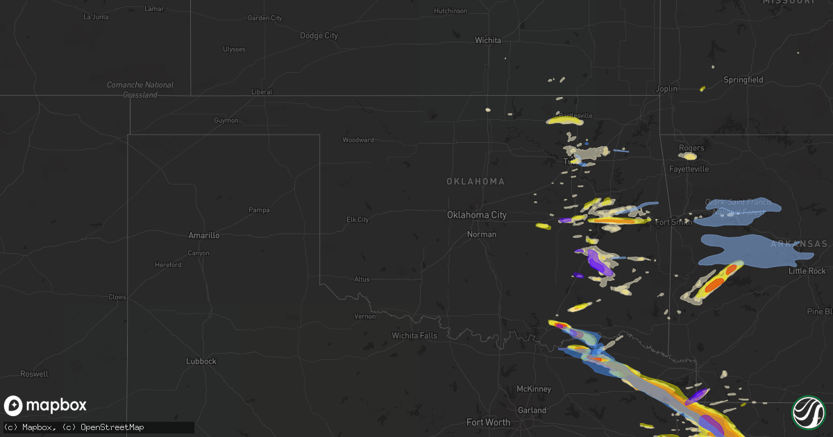
Hail Map in Oklahoma on April 24, 2020
Get this storm
April 24 map
$229
one time, instant access
Download today. No call, no setup
Keep the $229
Bought the map and want the full workflow? Apply the entire $229 to a subscription within 7 days. None of it is wasted.
Every map, not just this one
This buys you this map. Subscription and you get every map we run, in the markets you choose from a few cities to whole states to nationwide. Plus real-time alerts the moment a storm fires.
Contact data
Name, contact info, occupancy, even credit band for addresses in the footprint. You go from where it hit to who to call.
Become the source they trust
Unlimited branding weather history reports on demand. You already have the documented answer ready for the property owner, and you are the one who showed up with it.
Property data and RoofTrace estimates
Pull up any address you have got, its value and the exact code rules for that jurisdiction, straight from One Click Code. Then RoofTrace estimates the squares, pitch, and roof value, priced the way you price.
Storm reports in Oklahoma
Oklahoma
| Date | Description |
|---|---|
| 04/24/20206:59 PM CDT | A local report indicates 1.00 inch wind near 6 NW MCALESTER |
| 04/24/20206:57 PM CDT | A local report indicates 1.00 inch wind near INDIANOLA |
| 04/24/20206:53 PM CDT | A local report indicates 2.00 inch wind near BENNINGTON |
| 04/24/20206:53 PM CDT | A local report indicates a tornado near 4 SW BENNINGTON |
| 04/24/20206:45 PM CDT | Windows broken at the rock creek school in bokchito. |
| 04/24/20206:23 PM CDT | Spotter measured wind gust to 65 mph. Tree limbs 2-3 inches in diameter snapped. |
| 04/24/20206:23 PM CDT | A local report indicates 1.00 inch wind near 2 S PRYOR |
| 04/24/20206:15 PM CDT | Relayed via twitter. |
| 04/24/20205:58 PM CDT | A local report indicates 1.50 inch wind near 3 N PORUM |
| 04/24/20205:57 PM CDT | A local report indicates 60 MPH wind near 4 NNW BROKEN ARROW |
| 04/24/20205:52 PM CDT | A local report indicates 1.00 inch wind near 2 N PORUM |
| 04/24/20205:45 PM CDT | A local report indicates 1.50 inch wind near 8 SE CHECOTAH |
| 04/24/20205:35 PM CDT | Observed at texanna |
| 04/24/20205:35 PM CDT | Observed at texanna |
| 04/24/20205:33 PM CDT | A local report indicates 59 MPH wind near TULSA INTERNATIONAL AIR |
| 04/24/20205:27 PM CDT | Reported at 4900 w keystone |
| 04/24/20205:25 PM CDT | A local report indicates 1.00 inch wind near 1 S MUSKOGEE |
| 04/24/20204:43 PM CDT | Media report of quarter size hail on south side of bartlesville. |
| 04/24/20203:07 AM CDT | At 807 PM CDT, severe thunderstorms were located along a line extending from 3 miles northeast of Pea Ridge to Springdale to 4 miles east of Adair State Park, moving east at 40 mph. HAZARD...60 mph wind gusts and nickel size hail. SOURCE...Radar indicated. IMPACT...Expect damage to roofs, siding, and trees. Locations in or near the path include... Fayetteville... Springdale... Rogers... Bentonville... Berryville... Stilwell... Huntsville... Eureka Springs... Lowell... Farmington... Pea Ridge... Prairie Grove... Green Forest... Elkins... Tontitown... Bethel Heights... West Fork... Lincoln... Cave Springs... Greenland...This includes Interstate 49 between mile markers 44 and 89. |
| 04/24/20202:40 AM CDT | At 740 PM CDT, severe thunderstorms were located along a line extending from 2 miles northwest of Hiwasse to 6 miles southwest of Maryetta, moving east at 40 mph. HAZARD...60 mph wind gusts and nickel size hail. SOURCE...Radar indicated. IMPACT...Expect damage to roofs, siding, and trees. Locations in or near the path include... Fayetteville... Springdale... Rogers... Bentonville... Siloam Springs... Stilwell... Bella Vista... Lowell... Farmington... Pea Ridge... Prairie Grove... Gentry... Tontitown... Bethel Heights... Gravette... West Fork... Lincoln... Cave Springs... Decatur... Westville...This includes Interstate 49 between mile markers 45 and 93. |
| 04/24/20202:15 AM CDT | At 715 PM CDT, severe thunderstorms were located along a line extending from 8 miles north of Enterprise to 2 miles south of Arrowhead State Park, moving east at 30 mph. HAZARD...60 mph wind gusts and quarter size hail. SOURCE...Radar indicated. IMPACT...Hail damage to vehicles is expected. Expect wind damage to roofs, siding, and trees. Locations in or near the path include... Stigler... Quinton... Crowder... Whitefield... Arrowhead State Park... Briartown... Enterprise... Lewisville... |
| 04/24/20201:59 AM CDT | At 659 PM CDT, a severe thunderstorm was located 4 miles east of Checotah, moving east at 35 mph. HAZARD...60 mph wind gusts and quarter size hail. SOURCE...Radar indicated. IMPACT...Hail damage to vehicles is expected. Expect wind damage to roofs, siding, and trees. Locations in or near the path include... Sallisaw... Checotah... Warner... Vian... Gore... Porum... Webbers Falls... Oktaha... Marble City... Tamaha... Rentiesville... Brushy Lake State Park... Keefeton... Box... Mc Key... This includes Interstate 40 in Oklahoma between mile markers 265 and305. |
| 04/24/20201:48 AM CDT | At 648 PM CDT, a severe thunderstorm was located 5 miles south of Lane, moving east at 30 mph. HAZARD...Golf ball size hail and 60 mph wind gusts. SOURCE...Radar indicated. IMPACT...People and animals outdoors will be injured. Expect hail damage to roofs, siding, windows, and vehicles. Expect wind damage to roofs, siding, and trees. Locations impacted include... Lane, southeastern McGee Creek Lake, Bentley and Darwin. |
| 04/24/20201:45 AM CDT | At 645 PM CDT, a severe thunderstorm was located near Honey Grove, or 15 miles west of Paris, moving east at 20 mph. HAZARD...60 mph wind gusts and quarter size hail. SOURCE...Radar indicated. IMPACT...Hail damage to vehicles is expected. Expect wind damage to roofs, siding, and trees. Locations impacted include... Paris, Blossom, Deport, Roxton, Toco and Sun Valley. |
| 04/24/20201:27 AM CDT | At 627 PM CDT, severe thunderstorms were located along a line extending from 4 miles southwest of Adair to near Sportsmen Acres Community to 6 miles northwest of Wagoner, moving east at 35 mph. HAZARD...60 mph wind gusts and nickel size hail. SOURCE...Radar indicated. IMPACT...Expect damage to roofs, siding, and trees. Locations in or near the path include... Wagoner... Jay... Pryor... Pryor Creek... Chouteau... Locust Grove... Salina... Kansas... Adair... Spavinaw... Oaks... Hoot Owl... Peggs... Rose... Spavinaw State Park... Leach... Chloeta... Twin Oaks... Sportsmen Acres Community... Strang... |
| 04/24/20201:21 AM CDT | At 621 PM CDT, a severe thunderstorm was located over Armstrong, moving east at 30 mph. HAZARD...Ping pong ball size hail and 60 mph wind gusts. SOURCE...Radar indicated. IMPACT...People and animals outdoors will be injured. Expect hail damage to roofs, siding, windows, and vehicles. Expect wind damage to roofs, siding, and trees. Locations impacted include... Durant, Caddo, Bokchito, Bennington, Kenefic, Armstrong and Blue. |
| 04/24/202012:51 AM CDT | At 551 PM CDT, a severe thunderstorm was located 5 miles southwest of Cromwell, moving east at 30 mph. HAZARD...Ping pong ball size hail and 60 mph wind gusts. SOURCE...Radar indicated. IMPACT...People and animals outdoors will be injured. Expect hail damage to roofs, siding, windows, and vehicles. Expect wind damage to roofs, siding, and trees. Locations impacted include... Wetumka, Dustin and Cromwell. |
| 04/24/202012:41 AM CDT | At 541 PM CDT, severe thunderstorms were located along a line extending from 3 miles northwest of Catoosa to 2 miles northwest of Bixby, moving east at 30 mph. HAZARD...60 mph wind gusts and quarter size hail. SOURCE...Radar indicated. IMPACT...Hail damage to vehicles is expected. Expect wind damage to roofs, siding, and trees. Locations in or near the path include... Tulsa... Broken Arrow... Bixby... Jenks... Coweta... Catoosa... Verdigris... Inola... Tulsa International Airport... Oneta...This includes Interstate 44 between mile markers 224 and 242. |
| 04/24/202012:18 AM CDT | At 517 PM CDT, a severe thunderstorm was located over Sperry, moving east at 35 mph. HAZARD...60 mph wind gusts and quarter size hail. SOURCE...Radar indicated. IMPACT...Hail damage to vehicles is expected. Expect wind damage to roofs, siding, and trees. Locations in or near the path include... Tulsa... Claremore... Owasso... Skiatook... Collinsville... Verdigris... Sperry... Oologah... Foyil... Turley... Taiwah... Tiawah...This includes Interstate 44 between mile markers 243 and 254. |
| 04/23/202011:06 PM CDT | At 405 PM CDT, a severe thunderstorm was located over Pawhuska, moving east at 30 mph. HAZARD...60 mph wind gusts and quarter size hail. SOURCE...Radar indicated. IMPACT...Hail damage to vehicles is expected. Expect wind damage to roofs, siding, and trees. Locations in or near the path include... Bartlesville... Pawhuska... Dewey... Osage Hills State Park... Bartlesville Municipal Airport... Okesa... Nelagoney... |
| 04/23/20207:55 PM CDT | Hail at intersection of hwy 37 and hwy 98... West of idabel. |
| 04/23/20207:53 PM CDT | Social media pictures show a carport roof was removed and a tree was found uprooted about 2 miles east of highway 2. Time is estimated from radar. |
| 04/23/20207:50 PM CDT | A local report indicates 1.25 inch wind near 5 S HARTSHORNE |
| 04/23/20207:00 PM CDT | A local report indicates 1.75 inch wind near 7 ESE LANE |
All States Impacted by Hail Map on April 24, 2020
Cities Impacted by Hail Map on April 24, 2020
- Englewood, FL
- Venice, FL
- Gloster, LA
- Keithville, LA
- Stonewall, LA
- Bogata, TX
- Deport, TX
- Waller, TX
- Navasota, TX
- Anderson, TX
- Plantersville, TX
- Magnolia, TX
- Shreveport, LA
- Benton, LA
- Princeton, LA
- Bossier City, LA
- Haughton, LA
- Pryor, OK
- Mena, AR
- Sumner, TX
- Honey Grove, TX
- Sapulpa, OK
- Wister, OK
- Red Oak, OK
- Heavener, OK
- College Station, TX
- Lewisville, AR
- Pinehurst, TX
- Jamestown, LA
- Ringgold, LA
- Perry, MO
- Center, MO
- Ramona, OK
- Ochelata, OK
- Barnsdall, OK
- Pawhuska, OK
- Bartlesville, OK
- Joaquin, TX
- Tulsa, OK
- Skiatook, OK
- Sperry, OK
- Owasso, OK
- Inola, OK
- Claremore, OK
- Tatum, TX
- Sims, AR
- Catoosa, OK
- Broken Arrow, OK
- Talco, TX
- Naples, TX
- Cookville, TX
- Mount Pleasant, TX
- Omaha, TX
- Winnfield, LA
- Kelly, LA
- Columbia, LA
- Tullos, LA
- Olla, LA
- Grayson, LA
- Sikes, LA
- Mcalester, OK
- Oden, AR
- Norman, AR
- Pencil Bluff, AR
- Mount Ida, AR
- Bedias, TX
- Carthage, TX
- Henderson, TX
- Mansfield, LA
- Kilgore, TX
- De Berry, TX
- Logansport, LA
- Campti, LA
- Coushatta, LA
- Keatchie, LA
- Beckville, TX
- Overton, TX
- Pelican, LA
- Grand Cane, LA
- Okemah, OK
- Wewoka, OK
- Atoka, OK
- Lane, OK
- Goochland, VA
- Powhatan, VA
- Columbia, VA
- Cartersville, VA
- Checotah, OK
- Porum, OK
- Jefferson City, MO
- Centertown, MO
- Indianola, OK
- Pattonville, TX
- Douglassville, TX
- Rodessa, LA
- Ashland, LA
- Gilliam, LA
- Telephone, TX
- Bloomburg, TX
- Blossom, TX
- Mount Vernon, TX
- Sibley, LA
- Atlanta, TX
- Waskom, TX
- Karnack, TX
- Chatham, LA
- Goldonna, LA
- Bienville, LA
- Marshall, TX
- Heflin, LA
- Brookston, TX
- Jefferson, TX
- Bethany, LA
- Barksdale Afb, LA
- Jonesboro, LA
- Gibsland, LA
- Frierson, LA
- Elm Grove, LA
- Hosston, LA
- Roxton, TX
- Fouke, AR
- Belcher, LA
- Oil City, LA
- Lake Creek, TX
- Quitman, LA
- Hallsville, TX
- Powderly, TX
- Hughes Springs, TX
- Daingerfield, TX
- Petty, TX
- Linden, TX
- Avinger, TX
- Vivian, LA
- Ida, LA
- Dubberly, LA
- Sulphur Bluff, TX
- Doddridge, AR
- Ivanhoe, TX
- Marietta, TX
- Bivins, TX
- Saline, LA
- Minden, LA
- Doyline, LA
- Paris, TX
- Castor, LA
- Mooringsport, LA
- Greenwood, LA
- Plain Dealing, LA
- Dodson, LA
- Queen City, TX
- Corrigan, TX
- Moscow, TX
- Groveton, TX
- Kennard, TX
- Bennington, OK
- Durant, OK
- Bokchito, OK
- Henryetta, OK
- Morris, OK
- Okmulgee, OK
- Council Hill, OK
- Hartshorne, OK
- Haileyville, OK
- Tuskahoma, OK
- Wilburton, OK
- Shongaloo, LA
- Santa Fe, MO
- Stoutsville, MO
- Arthur City, TX
- Boswell, OK
- Caddo, OK
- Montgomery, TX
- Tomball, TX
- Houston, TX
- Spring, TX
- Hempstead, TX
- Hockley, TX
- Cypress, TX
- Oktaha, OK
- Hanna, OK
- Chesterfield, VA
- Colonial Heights, VA
- Hopewell, VA
- Moseley, VA
- Henrico, VA
- Prince George, VA
- Midlothian, VA
- Chester, VA
- Richmond, VA
- Charles City, VA
- Nashoba, OK
- Rattan, OK
- Weleetka, OK
- Stigler, OK
- Eufaula, OK
- Warner, OK
- Webbers Falls, OK
- Ruston, LA
- Gilmer, TX
- Honobia, OK
- Pittsburg, OK
- Clayton, OK
- Springdale, AR
- Lowell, AR
- Fayetteville, AR
- Alma, AR
- Dyer, AR
- Paris, MO
- Crockett, TX
- Pennington, TX
- Cedar Vale, KS
- Collinsville, OK
- Midway, TX
- Loami, IL
- Beggs, OK
- Winchester, IL
- Blackwell, OK
- Haynesville, LA
- Antlers, OK
- Caney, OK
- Oakwood, TX
- Apple Springs, TX
- Plainview, AR
- Story, AR
- Grannis, AR
- Gillham, AR
- Stamps, AR
- Longview, TX
- Russellville, MO
- Eugene, MO
- Boynton, OK
- Taylor, AR
- Diana, TX
- Crowder, OK
- Ponca City, OK
- Krebs, OK
- Bristow, OK
- Union Church, MS
- Watson, OK
- Huntsville, TX
- Sallisaw, OK
- Grapeland, TX
- Eagletown, OK
- Bentonville, AR
- Cave Springs, AR
- Rogers, AR
- Gentry, AR
- Warrenton, MO
- Berger, MO
- Marthasville, MO
- Umpire, AR
- Bremo Bluff, VA
- Palmyra, VA
- Fork Union, VA
- Gore, OK
- Muskogee, OK
- Vian, OK
- Snow, OK
- Canadian, OK
- Stroud, OK
- Seminole, OK
- Smithville, OK
- Cecil, AR
- Detroit, TX
- Whitefield, OK
- Lamar, AR
- Paden, OK
- West Monroe, LA
- Farmerville, LA
- Glenpool, OK
- Bixby, OK
- Blanchard, LA
- Pattison, MS
- Newhope, AR
- Vandervoort, AR
- Everton, MO
- South Greenfield, MO
- Gary, TX
- Tenaha, TX
- Charleston, AR
- Van Buren, AR
- Whitesboro, OK
- Olean, MO
- Muldrow, OK
- Gans, OK
- Iola, TX
- Bryan, TX
- Oologah, OK
- Clarksville, AR
- Sedan, KS
- Hartsburg, MO
- Ashland, MO
- Emerson, AR
- Slater, MO
- Miami, MO
- Mounds, OK
- Salisbury, MO
- Magnolia, AR
- Cotton Valley, LA
- Sarepta, LA
- Jenks, OK
- New Berlin, IL
- Ashland, IL
- Fulton, MO
- Kiowa, OK
- Stotts City, MO
- Pierce City, MO
- Talihina, OK
- Long Branch, TX
- Marion, LA
- Falcon, MO
- De Queen, AR
- Wardville, OK
- Hartman, AR
- Madisonville, TX
- Keota, OK
- Howe, OK
- Douglass, KS
- Udall, KS
- Blue Mountain, AR
- Belleville, AR
- Adona, AR
- Perryville, AR
- Gravelly, AR
- Russellville, AR
- Harvey, AR
- Conway, AR
- Dardanelle, AR
- Sherwood, AR
- Roland, AR
- North Little Rock, AR
- Parks, AR
- Maumelle, AR
- Houston, AR
- Morrilton, AR
- Casa, AR
- Rover, AR
- Briggsville, AR
- Atkins, AR
- Perry, AR
- Danville, AR
- Havana, AR
- Little Rock, AR
- Mayflower, AR
- Booneville, AR
- Paris, AR
- Magazine, AR
- Bigelow, AR
- Ola, AR
- Bluffton, AR
- Pottsville, AR
- Paron, AR
- Jacksonville, AR
- Waldron, AR
- Scotland, AR
- Hector, AR
- Clinton, AR
- Dover, AR
- Oark, AR
- Pelsor, AR
- Ozark, AR
- Jerusalem, AR
- Ozone, AR
- Witts Springs, AR
- Hagarville, AR
- Scranton, AR
- London, AR
- Branch, AR
- Subiaco, AR
- Knoxville, AR
- Coal Hill, AR
- Altus, AR
- New Blaine, AR
- Ratcliff, AR
- Hugo, OK
- Bunch, OK
- Salina, OK
- Spavinaw, OK
- Wetumka, OK
- Dodd City, TX
- Bonham, TX
- Ravenna, TX
- Windom, TX
- Enloe, TX
- Cooper, TX
- Wentworth, MO
- Mount Vernon, MO
- Schuyler, VA
- Esmont, VA
- North Garden, VA
- De Kalb, TX
- Simms, TX


