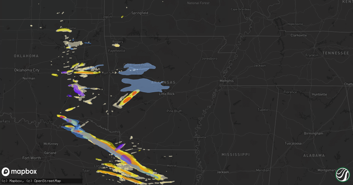
Hail Map in Arkansas on April 24, 2020
Get this storm
April 24 map
$229
one time, instant access
Download today. No call, no setup
Keep the $229
Bought the map and want the full workflow? Apply the entire $229 to a subscription within 7 days. None of it is wasted.
Every map, not just this one
This buys you this map. Subscription and you get every map we run, in the markets you choose from a few cities to whole states to nationwide. Plus real-time alerts the moment a storm fires.
Contact data
Name, contact info, occupancy, even credit band for addresses in the footprint. You go from where it hit to who to call.
Become the source they trust
Unlimited branding weather history reports on demand. You already have the documented answer ready for the property owner, and you are the one who showed up with it.
Property data and RoofTrace estimates
Pull up any address you have got, its value and the exact code rules for that jurisdiction, straight from One Click Code. Then RoofTrace estimates the squares, pitch, and roof value, priced the way you price.
Storm reports in Arkansas
Arkansas
| Date | Description |
|---|---|
| 04/24/20205:45 PM CDT | A local report indicates 1.50 inch wind near 3 S SHADY GROVE |
| 04/24/202011:18 AM CDT | Tree down on interstate 40 |
| 04/24/20206:05 AM CDT | At 1104 PM CDT, severe thunderstorms were located along a line extending from 6 miles northeast of Mayflower to Maumelle to 10 miles northwest of Salem in Saline County, moving east at 40 mph. HAZARD...60 mph wind gusts and nickel size hail. SOURCE...Radar indicated. IMPACT...Expect damage to roofs, siding, and trees. Locations impacted include... Little Rock... North Little Rock... Sherwood... Jacksonville... Cabot... West Little Rock... Downtown Little Rock... Lonoke... North Little Rock Airport... Little Rock AFB... Southwest Little Rock... Ward... Austin in Lonoke County... Argenta... Otter Creek... Old Austin... Parnell... Gravel Ridge... Meto... Protho Junction...This includes the following highways... Interstate 30 between mile markers 129 and 142. Interstate 40 between mile markers 148 and 172. Interstate 430 between mile markers 1 and 7. Interstate 530 between mile markers 1 and 5. Interstate 630 between mile markers 1 and 7. Interstate 440 between mile markers 1 and 14. US Highway 67 between mile markers 1 and 25. |
| 04/24/20205:54 AM CDT | At 1054 PM CDT, severe thunderstorms were located along a line extending from Old Lexington to near Choctaw, moving east at 40 mph. HAZARD...60 mph wind gusts and nickel size hail. SOURCE...Radar indicated. IMPACT...Expect damage to roofs, siding, and trees. Locations impacted include... Heber Springs... Clinton... Fairfield Bay... Greers Ferry... Shirley... Higden... Fairfield Bay Marina... Fairbanks... Sugar Loaf Recreation Area... Old Lexington... Choctaw... Bee Branch... Parma... Rushing... Turkey Creek... Ida... Brownsville... Narrows Marina... Botkinburg... Brewer... |
| 04/24/20205:37 AM CDT | At 1037 PM CDT, severe thunderstorms were located along a line extending from near Claude to near Houston to near Jessieville, moving east at 45 mph. HAZARD...60 mph wind gusts and quarter size hail. SOURCE...Radar indicated. IMPACT...Hail damage to vehicles is expected. Expect wind damage to roofs, siding, and trees. Locations impacted include... Little Rock... North Little Rock... Conway... Cabot... West Little Rock... Maumelle... Hot Springs Village... Greenbrier... Vilonia... Mayflower... Wooster... Quitman... Guy... Rose Bud... Damascus... Enola... Twin Groves... Menifee... Houston... Mount Vernon...This includes the following highways... Interstate 40 between mile markers 113 and 148. Interstate 430 between mile markers 7 and 12. |
| 04/24/20205:29 AM CDT | At 1029 PM CDT, a severe thunderstorm was located over St. Vincent, or 11 miles north of Morrilton, moving east at 45 mph. HAZARD...60 mph wind gusts. SOURCE...Radar indicated. IMPACT...Expect damage to roofs, siding, and trees. Locations impacted include... Damascus... Twin Groves... Bethlehem... Lanty... Mallet Town... Whipple... St. Vincent... Catholic Point... Blick... Hattieville... Springfield... Middleton... Solgohachia... Birdtown... Bee Branch... Southside in Van Buren County... Martinville... Wonderview... Macedonia in Conway County... Center Ridge... |
| 04/24/20205:19 AM CDT | At 1018 PM CDT, a severe thunderstorms were located 9 miles south of Plainview in Yell County, or 15 miles southeast of Danville, moving east at 50 mph. HAZARD...Ping pong ball size hail and 60 mph wind gusts. SOURCE...Radar indicated. IMPACT...People and animals outdoors will be injured. Expect hail damage to roofs, siding, windows, and vehicles. Expect wind damage to roofs, siding, and trees. Locations impacted include... Hot Springs Village... Jessieville... Williams Junction... Plainview in Yell County... Carter Cove Park... Nimrod... Deberrie... Mt Tabor... Lena Landing Rec Area... Long Mountain... Hamilton... Fourche Junction... Thornburg... Hollis... Reform... Sunlight Bay Park... Garden Point Recreation Area... |
| 04/24/20205:15 AM CDT | At 1015 PM CDT, a severe thunderstorm was located over Atkins, or 12 miles east of Russellville, moving east at 45 mph. HAZARD...60 mph wind gusts and quarter size hail. SOURCE...Radar indicated. IMPACT...Hail damage to vehicles is expected. Expect wind damage to roofs, siding, and trees. Locations impacted include... Russellville... Morrilton... Perryville... Dardanelle... Atkins... Pottsville... Ola... Oppelo... Menifee... Perry... Adona... Houston... Bethlehem... Sequoya Park... Hill Creek... Carden Bottoms... Happy Bend... Solgohachia... Hattieville... Petit Jean State Park...This includes Interstate 40 between mile markers 87 and 116. |
| 04/24/20204:56 AM CDT | At 956 PM CDT, severe thunderstorms were located along a line extending from near Dillen to 6 miles north of Broomfield to Dover to near Russellville, moving east at 45 mph. HAZARD...60 mph wind gusts and quarter size hail. SOURCE...Radar indicated. IMPACT...Hail damage to vehicles is expected. Expect wind damage to roofs, siding, and trees. Locations impacted include... Russellville... Dover... London... Hector... Claude... Cleveland... Broomfield... Dabney... Hattieville... Solo... Middleton... Smyrna... Lanty... Jerusalem... St. Vincent... Blick... Taral... Woolum... Lake Dardanelle... Appleton...This includes Interstate 40 between mile markers 78 and 84. |
| 04/24/20204:47 AM CDT | At 946 PM CDT, severe thunderstorms were located along a line extending from Mount Magazine to 6 miles southwest of Gravelly, moving southeast at 35 mph. HAZARD...60 mph wind gusts and quarter size hail. SOURCE...Radar indicated. IMPACT...Hail damage to vehicles is expected. Expect wind damage to roofs, siding, and trees. Locations impacted include... Russellville... Danville... Dardanelle... Pottsville... Ola... Stonehouse Recreation Area... Mt Nebo State Park... Gravelly... Fourche Valley... Mount Magazine... Plainview in Yell County... Petit Jean River WMA... Mosley... Lake Dardanelle State Park... Belleville... Havana... Corinth... Birta... Ranger... Wing...This includes Interstate 40 between mile markers 87 and 89. |
| 04/24/20204:43 AM CDT | At 942 PM CDT, a severe thunderstorm was located over Mauldin, or over Mount Ida, moving northeast at 50 mph. HAZARD...60 mph wind gusts and half dollar size hail. SOURCE...Radar indicated. IMPACT...Hail damage to vehicles is expected. Expect wind damage to roofs, siding, and trees. Locations impacted include... Mount Ida... Norman... Oden... Mauldin... Jessieville... Avant... Black Springs... Carter Cove Park... Gibbs... Pencil Bluff... Mt Tabor... Fannie... Lena Landing Rec Area... Silver... Hamilton... Onyx... Sims... Hurricane Grove... Story... Washita... |
| 04/24/20204:36 AM CDT | At 936 PM CDT, severe thunderstorms were located along a line extending from near Devils Knob to 7 miles northwest of Holman to near Knoxville, moving east at 50 mph. HAZARD...60 mph wind gusts and quarter size hail. SOURCE...Radar indicated. IMPACT...Hail damage to vehicles is expected. Expect wind damage to roofs, siding, and trees. Locations impacted include... Dover... Knoxville... Dillen... Broomfield... Bertha... Holman... Rosetta... Lake Dardanelle... Augsburg... Fort Douglas... Lutherville... Long Pool Campground... Haw Creek Falls Campground... Piney Bay Recreation Area... Treat... Pleasant Valley in Pope County... Sand Gap... Simpson... Mineral Springs Recreation Area...This includes Interstate 40 near mile marker 66. |
| 04/24/20204:30 AM CDT | At 929 PM CDT, a severe thunderstorm was located near Subiaco, or near Paris, moving east at 45 mph. HAZARD...60 mph wind gusts and quarter size hail. SOURCE...Radar indicated. IMPACT...Hail damage to vehicles is expected. Expect wind damage to roofs, siding, and trees. Locations impacted include... Russellville... Dover... London... Knoxville... Scranton... Lake Dardanelle... Midway in Logan County... Tokalon... Taral... Morrison Bluff... Dublin... Ludwig... Piney Bay Recreation Area... Delaware... New Blaine... This includes Interstate 40 between mile markers 66 and 81. |
| 04/24/20204:23 AM CDT | At 922 PM CDT, a severe thunderstorm was located near Beauchamp, or 8 miles north of Mena, moving east at 45 mph. HAZARD...60 mph wind gusts and quarter size hail. SOURCE...Radar indicated. IMPACT...Hail damage to vehicles is expected. Expect wind damage to roofs, siding, and trees. Locations impacted include... Mena... Waldron... Mansfield... Beauchamp... Stonehouse Recreation Area... Cardiff... Echo... Oliver... Morgan Springs... Queen Wilhelmina State Park... Acorn... Winfield... Olio... Boles... Grayson... Shady Grove... Ione... Elm Park... Union Hill... Rocky... |
| 04/24/20204:05 AM CDT | At 904 PM CDT, a severe thunderstorm was located over Athens, or near Umpire, moving northeast at 55 mph. HAZARD...60 mph wind gusts and quarter size hail. SOURCE...Radar indicated. IMPACT...Hail damage to vehicles is expected. Expect wind damage to roofs, siding, and trees. Locations impacted include... Mount Ida... Norman... Oden... Opal... Mimosa... Little Missouri Falls Recreatio... Cossatot River State Park... Mccauley... Shady... Hartley... Bard Springs Recreation Area... Caney Creek Wilderness... Mauldin... Albert Pike Recreation Area... Black Springs... Big Fork... Langley... Pine Ridge... Shady Lake Recreation Area... Fancyhill... |
| 04/24/20203:57 AM CDT | At 856 PM CDT, severe thunderstorms were located along a line extending from 8 miles southeast of Winslow to 6 miles southeast of Fern to 6 miles north of Branch to near Charleston, moving east at 35 mph. HAZARD...60 mph wind gusts and quarter size hail. SOURCE...Radar indicated. IMPACT...Hail damage to vehicles is expected. Expect wind damage to roofs, siding, and trees. Locations impacted include... Clarksville... Paris... Lamar... Knoxville... Subiaco... Hartman... Scranton... Ratcliff... Woodland... Hinkle... Devils Knob... Hoyt... Midway in Logan County... Spadra... Tokalon... Rosetta... Mount Magazine... Lake Dardanelle... Coal Hill... Caulksville...This includes Interstate 40 between mile markers 44 and 67. |
| 04/24/20203:47 AM CDT | At 847 PM CDT, a severe thunderstorm was located over Fouke, or 12 miles south of Texarkana, moving east at 50 mph. HAZARD...60 mph wind gusts and quarter size hail. SOURCE...Radar indicated. IMPACT...Hail damage to vehicles is expected. Expect wind damage to roofs, siding, and trees. Locations impacted include... Texarkana, Stamps, Lewisville, Fouke, Garland, Willisville, Bodcaw, Genoa, Mount Pleasant, Patmos, Falcon, Pleasant Hill, Spirit Lake and Piney Grove. |
| 04/24/20203:37 AM CDT | At 837 PM CDT, a severe thunderstorm was located near Shongaloo, or 7 miles southeast of Springhill, moving east at 40 mph. HAZARD...60 mph wind gusts and quarter size hail. SOURCE...Radar indicated. IMPACT...Hail damage to vehicles is expected. Expect wind damage to roofs, siding, and trees. Locations impacted include... Springhill, Haynesville, Cullen, Shongaloo, Atlanta, Hew Hope, Leton, Three Creeks, Corney Lake, Antioch and Summerfield. |
| 04/24/20202:03 AM CDT | At 702 PM CDT, severe thunderstorms were located along a line extending from 5 miles north of Twin Oaks to near Hulbert, moving east at 40 mph. HAZARD...60 mph wind gusts and nickel size hail. SOURCE...Radar indicated. IMPACT...Expect damage to roofs, siding, and trees. Locations in or near the path include... Rogers... Bentonville... Tahlequah... Siloam Springs... Stilwell... Gentry... Tontitown... Lincoln... Cave Springs... Decatur... Westville... West Siloam Springs... Colcord... Kansas... Hulbert... Highfill... Watts... Oaks... Springtown... Adair State Park...This includes Interstate 49 near mile marker 82. |
| 04/24/20201:30 AM CDT | Large tree blown down on bradley county road 34. |
| 04/23/202011:36 PM CDT | Received a report of multiple large trees knocked over onto two houses with minor structural damage. |
| 04/23/202011:36 PM CDT | Widespread trees and powerlines down east of cabot on highway 31 and jackson rd. |
| 04/23/202011:36 PM CDT | Received a report of multiple large trees knocked over onto two houses with minor structural damage. |
| 04/23/202011:34 PM CDT | Large tree limbs broken and power poles down on honeysuckle lane. |
| 04/23/202011:29 PM CDT | Little rock air force base reported a thunderstorm wind gust of 65 mph. |
| 04/23/202011:18 PM CDT | Tree down on interstate 40 |
| 04/23/202011:12 PM CDT | Power lines and trees were down with a tree blocking the road on county line road south in vilonia. Also... Part of the metal roof of a church on county line road south |
| 04/23/202011:02 PM CDT | Lake maumelle fire department reports multiple trees down on powerlines and blocking roads in roland. |
| 04/23/202010:37 PM CDT | Law enforcement has received reports of trees down. |
| 04/23/202010:05 PM CDT | Reports of trees and powerlines down along state highway 27 and river rd. |
| 04/23/20209:37 PM CDT | Golf ball size reported on highyway 270 west of mt. Ida. |
| 04/23/20209:09 PM CDT | A tornado uprooted trees and snapped large tree limbs. |
| 04/23/20208:54 PM CDT | Report from 911 call center of a large tree downed near intersection of hwy 41s and hwy 96. |
| 04/23/20208:38 PM CDT | Dyer pd reported tree downed onto a house. |
| 04/23/20208:37 PM CDT | Several trees down. Time estimated via radar. |
| 04/23/20208:36 PM CDT | Hail photo submitted via social media near the doddridge community. |
| 04/23/20208:35 PM CDT | Hail photo posted via social media in the ravanna community. |
| 04/23/20208:02 PM CDT | Tree blocking highway 94 near brush creek. |
All States Impacted by Hail Map on April 24, 2020
Cities Impacted by Hail Map on April 24, 2020
- Englewood, FL
- Venice, FL
- Gloster, LA
- Keithville, LA
- Stonewall, LA
- Bogata, TX
- Deport, TX
- Waller, TX
- Navasota, TX
- Anderson, TX
- Plantersville, TX
- Magnolia, TX
- Shreveport, LA
- Benton, LA
- Princeton, LA
- Bossier City, LA
- Haughton, LA
- Pryor, OK
- Mena, AR
- Sumner, TX
- Honey Grove, TX
- Sapulpa, OK
- Wister, OK
- Red Oak, OK
- Heavener, OK
- College Station, TX
- Lewisville, AR
- Pinehurst, TX
- Jamestown, LA
- Ringgold, LA
- Perry, MO
- Center, MO
- Ramona, OK
- Ochelata, OK
- Barnsdall, OK
- Pawhuska, OK
- Bartlesville, OK
- Joaquin, TX
- Tulsa, OK
- Skiatook, OK
- Sperry, OK
- Owasso, OK
- Inola, OK
- Claremore, OK
- Tatum, TX
- Sims, AR
- Catoosa, OK
- Broken Arrow, OK
- Talco, TX
- Naples, TX
- Cookville, TX
- Mount Pleasant, TX
- Omaha, TX
- Winnfield, LA
- Kelly, LA
- Columbia, LA
- Tullos, LA
- Olla, LA
- Grayson, LA
- Sikes, LA
- Mcalester, OK
- Oden, AR
- Norman, AR
- Pencil Bluff, AR
- Mount Ida, AR
- Bedias, TX
- Carthage, TX
- Henderson, TX
- Mansfield, LA
- Kilgore, TX
- De Berry, TX
- Logansport, LA
- Campti, LA
- Coushatta, LA
- Keatchie, LA
- Beckville, TX
- Overton, TX
- Pelican, LA
- Grand Cane, LA
- Okemah, OK
- Wewoka, OK
- Atoka, OK
- Lane, OK
- Goochland, VA
- Powhatan, VA
- Columbia, VA
- Cartersville, VA
- Checotah, OK
- Porum, OK
- Jefferson City, MO
- Centertown, MO
- Indianola, OK
- Pattonville, TX
- Douglassville, TX
- Rodessa, LA
- Ashland, LA
- Gilliam, LA
- Telephone, TX
- Bloomburg, TX
- Blossom, TX
- Mount Vernon, TX
- Sibley, LA
- Atlanta, TX
- Waskom, TX
- Karnack, TX
- Chatham, LA
- Goldonna, LA
- Bienville, LA
- Marshall, TX
- Heflin, LA
- Brookston, TX
- Jefferson, TX
- Bethany, LA
- Barksdale Afb, LA
- Jonesboro, LA
- Gibsland, LA
- Frierson, LA
- Elm Grove, LA
- Hosston, LA
- Roxton, TX
- Fouke, AR
- Belcher, LA
- Oil City, LA
- Lake Creek, TX
- Quitman, LA
- Hallsville, TX
- Powderly, TX
- Hughes Springs, TX
- Daingerfield, TX
- Petty, TX
- Linden, TX
- Avinger, TX
- Vivian, LA
- Ida, LA
- Dubberly, LA
- Sulphur Bluff, TX
- Doddridge, AR
- Ivanhoe, TX
- Marietta, TX
- Bivins, TX
- Saline, LA
- Minden, LA
- Doyline, LA
- Paris, TX
- Castor, LA
- Mooringsport, LA
- Greenwood, LA
- Plain Dealing, LA
- Dodson, LA
- Queen City, TX
- Corrigan, TX
- Moscow, TX
- Groveton, TX
- Kennard, TX
- Bennington, OK
- Durant, OK
- Bokchito, OK
- Henryetta, OK
- Morris, OK
- Okmulgee, OK
- Council Hill, OK
- Hartshorne, OK
- Haileyville, OK
- Tuskahoma, OK
- Wilburton, OK
- Shongaloo, LA
- Santa Fe, MO
- Stoutsville, MO
- Arthur City, TX
- Boswell, OK
- Caddo, OK
- Montgomery, TX
- Tomball, TX
- Houston, TX
- Spring, TX
- Hempstead, TX
- Hockley, TX
- Cypress, TX
- Oktaha, OK
- Hanna, OK
- Chesterfield, VA
- Colonial Heights, VA
- Hopewell, VA
- Moseley, VA
- Henrico, VA
- Prince George, VA
- Midlothian, VA
- Chester, VA
- Richmond, VA
- Charles City, VA
- Nashoba, OK
- Rattan, OK
- Weleetka, OK
- Stigler, OK
- Eufaula, OK
- Warner, OK
- Webbers Falls, OK
- Ruston, LA
- Gilmer, TX
- Honobia, OK
- Pittsburg, OK
- Clayton, OK
- Springdale, AR
- Lowell, AR
- Fayetteville, AR
- Alma, AR
- Dyer, AR
- Paris, MO
- Crockett, TX
- Pennington, TX
- Cedar Vale, KS
- Collinsville, OK
- Midway, TX
- Loami, IL
- Beggs, OK
- Winchester, IL
- Blackwell, OK
- Haynesville, LA
- Antlers, OK
- Caney, OK
- Oakwood, TX
- Apple Springs, TX
- Plainview, AR
- Story, AR
- Grannis, AR
- Gillham, AR
- Stamps, AR
- Longview, TX
- Russellville, MO
- Eugene, MO
- Boynton, OK
- Taylor, AR
- Diana, TX
- Crowder, OK
- Ponca City, OK
- Krebs, OK
- Bristow, OK
- Union Church, MS
- Watson, OK
- Huntsville, TX
- Sallisaw, OK
- Grapeland, TX
- Eagletown, OK
- Bentonville, AR
- Cave Springs, AR
- Rogers, AR
- Gentry, AR
- Warrenton, MO
- Berger, MO
- Marthasville, MO
- Umpire, AR
- Bremo Bluff, VA
- Palmyra, VA
- Fork Union, VA
- Gore, OK
- Muskogee, OK
- Vian, OK
- Snow, OK
- Canadian, OK
- Stroud, OK
- Seminole, OK
- Smithville, OK
- Cecil, AR
- Detroit, TX
- Whitefield, OK
- Lamar, AR
- Paden, OK
- West Monroe, LA
- Farmerville, LA
- Glenpool, OK
- Bixby, OK
- Blanchard, LA
- Pattison, MS
- Newhope, AR
- Vandervoort, AR
- Everton, MO
- South Greenfield, MO
- Gary, TX
- Tenaha, TX
- Charleston, AR
- Van Buren, AR
- Whitesboro, OK
- Olean, MO
- Muldrow, OK
- Gans, OK
- Iola, TX
- Bryan, TX
- Oologah, OK
- Clarksville, AR
- Sedan, KS
- Hartsburg, MO
- Ashland, MO
- Emerson, AR
- Slater, MO
- Miami, MO
- Mounds, OK
- Salisbury, MO
- Magnolia, AR
- Cotton Valley, LA
- Sarepta, LA
- Jenks, OK
- New Berlin, IL
- Ashland, IL
- Fulton, MO
- Kiowa, OK
- Stotts City, MO
- Pierce City, MO
- Talihina, OK
- Long Branch, TX
- Marion, LA
- Falcon, MO
- De Queen, AR
- Wardville, OK
- Hartman, AR
- Madisonville, TX
- Keota, OK
- Howe, OK
- Douglass, KS
- Udall, KS
- Blue Mountain, AR
- Belleville, AR
- Adona, AR
- Perryville, AR
- Gravelly, AR
- Russellville, AR
- Harvey, AR
- Conway, AR
- Dardanelle, AR
- Sherwood, AR
- Roland, AR
- North Little Rock, AR
- Parks, AR
- Maumelle, AR
- Houston, AR
- Morrilton, AR
- Casa, AR
- Rover, AR
- Briggsville, AR
- Atkins, AR
- Perry, AR
- Danville, AR
- Havana, AR
- Little Rock, AR
- Mayflower, AR
- Booneville, AR
- Paris, AR
- Magazine, AR
- Bigelow, AR
- Ola, AR
- Bluffton, AR
- Pottsville, AR
- Paron, AR
- Jacksonville, AR
- Waldron, AR
- Scotland, AR
- Hector, AR
- Clinton, AR
- Dover, AR
- Oark, AR
- Pelsor, AR
- Ozark, AR
- Jerusalem, AR
- Ozone, AR
- Witts Springs, AR
- Hagarville, AR
- Scranton, AR
- London, AR
- Branch, AR
- Subiaco, AR
- Knoxville, AR
- Coal Hill, AR
- Altus, AR
- New Blaine, AR
- Ratcliff, AR
- Hugo, OK
- Bunch, OK
- Salina, OK
- Spavinaw, OK
- Wetumka, OK
- Dodd City, TX
- Bonham, TX
- Ravenna, TX
- Windom, TX
- Enloe, TX
- Cooper, TX
- Wentworth, MO
- Mount Vernon, MO
- Schuyler, VA
- Esmont, VA
- North Garden, VA
- De Kalb, TX
- Simms, TX


