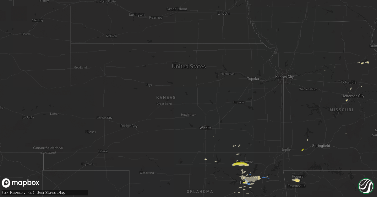
Hail Map in Kansas on April 24, 2020
Get this storm
April 24 map
$229
one time, instant access
Download today. No call, no setup
Keep the $229
Bought the map and want the full workflow? Apply the entire $229 to a subscription within 7 days. None of it is wasted.
Every map, not just this one
This buys you this map. Subscription and you get every map we run, in the markets you choose from a few cities to whole states to nationwide. Plus real-time alerts the moment a storm fires.
Contact data
Name, contact info, occupancy, even credit band for addresses in the footprint. You go from where it hit to who to call.
Become the source they trust
Unlimited branding weather history reports on demand. You already have the documented answer ready for the property owner, and you are the one who showed up with it.
Property data and RoofTrace estimates
Pull up any address you have got, its value and the exact code rules for that jurisdiction, straight from One Click Code. Then RoofTrace estimates the squares, pitch, and roof value, priced the way you price.
Storm reports in Kansas
Kansas
| Date | Description |
|---|---|
| 04/24/20203:45 PM CDT | Corrects previous tstm wnd dmg report from 1 s hale. Delayed report. Significant damage occurred at a farmstead just south of hale. Several 80+ year old trees were eith |
| 04/23/202010:37 PM CDT | At 336 PM CDT, a severe thunderstorm was located 8 miles south of Longton, or 10 miles northeast of Sedan, moving northeast at 30 mph. HAZARD...60 mph wind gusts and penny size hail. SOURCE...Radar indicated. IMPACT...Expect damage to roofs, siding, and trees. Locations impacted include... Neodesha, Fredonia, Longton, Elk City, Sycamore, New Albany, Hale, Buxton and Elk City Lake. |
All States Impacted by Hail Map on April 24, 2020
Cities Impacted by Hail Map on April 24, 2020
- Englewood, FL
- Venice, FL
- Gloster, LA
- Keithville, LA
- Stonewall, LA
- Bogata, TX
- Deport, TX
- Waller, TX
- Navasota, TX
- Anderson, TX
- Plantersville, TX
- Magnolia, TX
- Shreveport, LA
- Benton, LA
- Princeton, LA
- Bossier City, LA
- Haughton, LA
- Pryor, OK
- Mena, AR
- Sumner, TX
- Honey Grove, TX
- Sapulpa, OK
- Wister, OK
- Red Oak, OK
- Heavener, OK
- College Station, TX
- Lewisville, AR
- Pinehurst, TX
- Jamestown, LA
- Ringgold, LA
- Perry, MO
- Center, MO
- Ramona, OK
- Ochelata, OK
- Barnsdall, OK
- Pawhuska, OK
- Bartlesville, OK
- Joaquin, TX
- Tulsa, OK
- Skiatook, OK
- Sperry, OK
- Owasso, OK
- Inola, OK
- Claremore, OK
- Tatum, TX
- Sims, AR
- Catoosa, OK
- Broken Arrow, OK
- Talco, TX
- Naples, TX
- Cookville, TX
- Mount Pleasant, TX
- Omaha, TX
- Winnfield, LA
- Kelly, LA
- Columbia, LA
- Tullos, LA
- Olla, LA
- Grayson, LA
- Sikes, LA
- Mcalester, OK
- Oden, AR
- Norman, AR
- Pencil Bluff, AR
- Mount Ida, AR
- Bedias, TX
- Carthage, TX
- Henderson, TX
- Mansfield, LA
- Kilgore, TX
- De Berry, TX
- Logansport, LA
- Campti, LA
- Coushatta, LA
- Keatchie, LA
- Beckville, TX
- Overton, TX
- Pelican, LA
- Grand Cane, LA
- Okemah, OK
- Wewoka, OK
- Atoka, OK
- Lane, OK
- Goochland, VA
- Powhatan, VA
- Columbia, VA
- Cartersville, VA
- Checotah, OK
- Porum, OK
- Jefferson City, MO
- Centertown, MO
- Indianola, OK
- Pattonville, TX
- Douglassville, TX
- Rodessa, LA
- Ashland, LA
- Gilliam, LA
- Telephone, TX
- Bloomburg, TX
- Blossom, TX
- Mount Vernon, TX
- Sibley, LA
- Atlanta, TX
- Waskom, TX
- Karnack, TX
- Chatham, LA
- Goldonna, LA
- Bienville, LA
- Marshall, TX
- Heflin, LA
- Brookston, TX
- Jefferson, TX
- Bethany, LA
- Barksdale Afb, LA
- Jonesboro, LA
- Gibsland, LA
- Frierson, LA
- Elm Grove, LA
- Hosston, LA
- Roxton, TX
- Fouke, AR
- Belcher, LA
- Oil City, LA
- Lake Creek, TX
- Quitman, LA
- Hallsville, TX
- Powderly, TX
- Hughes Springs, TX
- Daingerfield, TX
- Petty, TX
- Linden, TX
- Avinger, TX
- Vivian, LA
- Ida, LA
- Dubberly, LA
- Sulphur Bluff, TX
- Doddridge, AR
- Ivanhoe, TX
- Marietta, TX
- Bivins, TX
- Saline, LA
- Minden, LA
- Doyline, LA
- Paris, TX
- Castor, LA
- Mooringsport, LA
- Greenwood, LA
- Plain Dealing, LA
- Dodson, LA
- Queen City, TX
- Corrigan, TX
- Moscow, TX
- Groveton, TX
- Kennard, TX
- Bennington, OK
- Durant, OK
- Bokchito, OK
- Henryetta, OK
- Morris, OK
- Okmulgee, OK
- Council Hill, OK
- Hartshorne, OK
- Haileyville, OK
- Tuskahoma, OK
- Wilburton, OK
- Shongaloo, LA
- Santa Fe, MO
- Stoutsville, MO
- Arthur City, TX
- Boswell, OK
- Caddo, OK
- Montgomery, TX
- Tomball, TX
- Houston, TX
- Spring, TX
- Hempstead, TX
- Hockley, TX
- Cypress, TX
- Oktaha, OK
- Hanna, OK
- Chesterfield, VA
- Colonial Heights, VA
- Hopewell, VA
- Moseley, VA
- Henrico, VA
- Prince George, VA
- Midlothian, VA
- Chester, VA
- Richmond, VA
- Charles City, VA
- Nashoba, OK
- Rattan, OK
- Weleetka, OK
- Stigler, OK
- Eufaula, OK
- Warner, OK
- Webbers Falls, OK
- Ruston, LA
- Gilmer, TX
- Honobia, OK
- Pittsburg, OK
- Clayton, OK
- Springdale, AR
- Lowell, AR
- Fayetteville, AR
- Alma, AR
- Dyer, AR
- Paris, MO
- Crockett, TX
- Pennington, TX
- Cedar Vale, KS
- Collinsville, OK
- Midway, TX
- Loami, IL
- Beggs, OK
- Winchester, IL
- Blackwell, OK
- Haynesville, LA
- Antlers, OK
- Caney, OK
- Oakwood, TX
- Apple Springs, TX
- Plainview, AR
- Story, AR
- Grannis, AR
- Gillham, AR
- Stamps, AR
- Longview, TX
- Russellville, MO
- Eugene, MO
- Boynton, OK
- Taylor, AR
- Diana, TX
- Crowder, OK
- Ponca City, OK
- Krebs, OK
- Bristow, OK
- Union Church, MS
- Watson, OK
- Huntsville, TX
- Sallisaw, OK
- Grapeland, TX
- Eagletown, OK
- Bentonville, AR
- Cave Springs, AR
- Rogers, AR
- Gentry, AR
- Warrenton, MO
- Berger, MO
- Marthasville, MO
- Umpire, AR
- Bremo Bluff, VA
- Palmyra, VA
- Fork Union, VA
- Gore, OK
- Muskogee, OK
- Vian, OK
- Snow, OK
- Canadian, OK
- Stroud, OK
- Seminole, OK
- Smithville, OK
- Cecil, AR
- Detroit, TX
- Whitefield, OK
- Lamar, AR
- Paden, OK
- West Monroe, LA
- Farmerville, LA
- Glenpool, OK
- Bixby, OK
- Blanchard, LA
- Pattison, MS
- Newhope, AR
- Vandervoort, AR
- Everton, MO
- South Greenfield, MO
- Gary, TX
- Tenaha, TX
- Charleston, AR
- Van Buren, AR
- Whitesboro, OK
- Olean, MO
- Muldrow, OK
- Gans, OK
- Iola, TX
- Bryan, TX
- Oologah, OK
- Clarksville, AR
- Sedan, KS
- Hartsburg, MO
- Ashland, MO
- Emerson, AR
- Slater, MO
- Miami, MO
- Mounds, OK
- Salisbury, MO
- Magnolia, AR
- Cotton Valley, LA
- Sarepta, LA
- Jenks, OK
- New Berlin, IL
- Ashland, IL
- Fulton, MO
- Kiowa, OK
- Stotts City, MO
- Pierce City, MO
- Talihina, OK
- Long Branch, TX
- Marion, LA
- Falcon, MO
- De Queen, AR
- Wardville, OK
- Hartman, AR
- Madisonville, TX
- Keota, OK
- Howe, OK
- Douglass, KS
- Udall, KS
- Blue Mountain, AR
- Belleville, AR
- Adona, AR
- Perryville, AR
- Gravelly, AR
- Russellville, AR
- Harvey, AR
- Conway, AR
- Dardanelle, AR
- Sherwood, AR
- Roland, AR
- North Little Rock, AR
- Parks, AR
- Maumelle, AR
- Houston, AR
- Morrilton, AR
- Casa, AR
- Rover, AR
- Briggsville, AR
- Atkins, AR
- Perry, AR
- Danville, AR
- Havana, AR
- Little Rock, AR
- Mayflower, AR
- Booneville, AR
- Paris, AR
- Magazine, AR
- Bigelow, AR
- Ola, AR
- Bluffton, AR
- Pottsville, AR
- Paron, AR
- Jacksonville, AR
- Waldron, AR
- Scotland, AR
- Hector, AR
- Clinton, AR
- Dover, AR
- Oark, AR
- Pelsor, AR
- Ozark, AR
- Jerusalem, AR
- Ozone, AR
- Witts Springs, AR
- Hagarville, AR
- Scranton, AR
- London, AR
- Branch, AR
- Subiaco, AR
- Knoxville, AR
- Coal Hill, AR
- Altus, AR
- New Blaine, AR
- Ratcliff, AR
- Hugo, OK
- Bunch, OK
- Salina, OK
- Spavinaw, OK
- Wetumka, OK
- Dodd City, TX
- Bonham, TX
- Ravenna, TX
- Windom, TX
- Enloe, TX
- Cooper, TX
- Wentworth, MO
- Mount Vernon, MO
- Schuyler, VA
- Esmont, VA
- North Garden, VA
- De Kalb, TX
- Simms, TX


