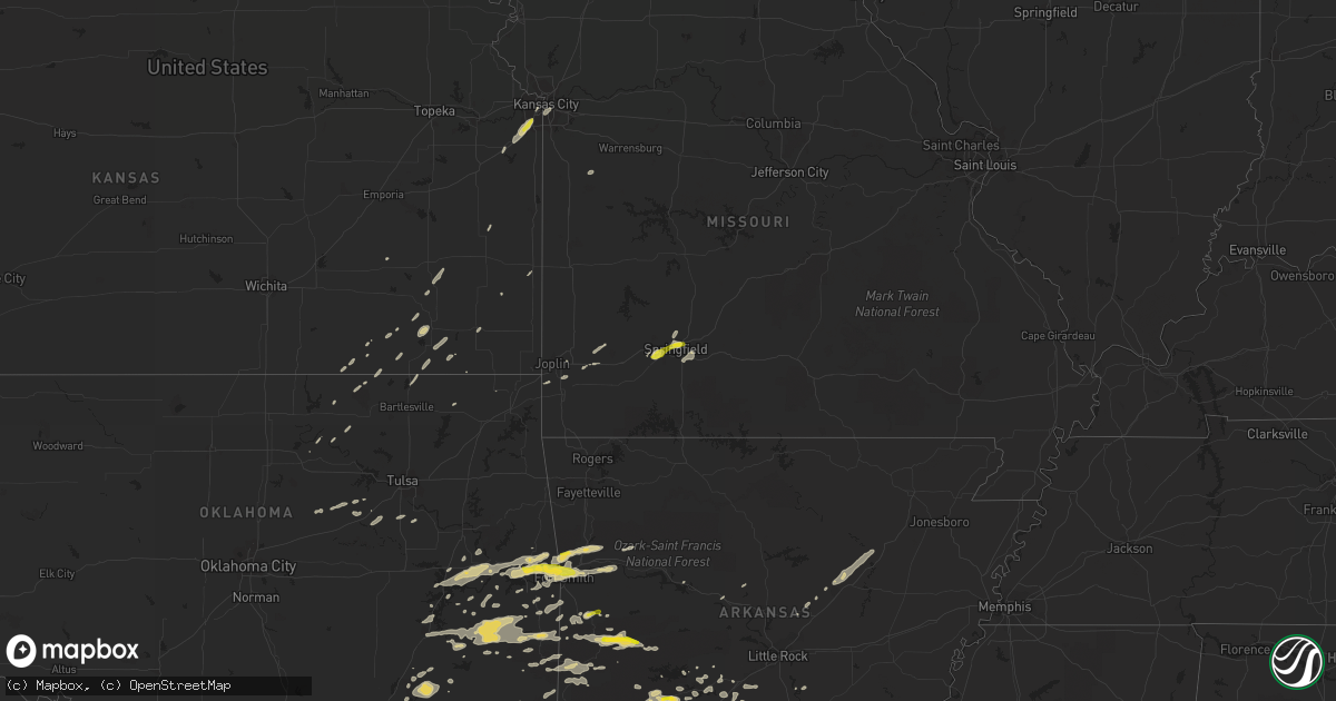
Hail Map on April 24, 2014
Get this storm
April 24 map
$229
one time, instant access
Download today. No call, no setup
Keep the $229
Bought the map and want the full workflow? Apply the entire $229 to a subscription within 7 days. None of it is wasted.
Every map, not just this one
This buys you this map. Subscription and you get every map we run, in the markets you choose from a few cities to whole states to nationwide. Plus real-time alerts the moment a storm fires.
Contact data
Name, contact info, occupancy, even credit band for addresses in the footprint. You go from where it hit to who to call.
Become the source they trust
Unlimited branding weather history reports on demand. You already have the documented answer ready for the property owner, and you are the one who showed up with it.
Property data and RoofTrace estimates
Pull up any address you have got, its value and the exact code rules for that jurisdiction, straight from One Click Code. Then RoofTrace estimates the squares, pitch, and roof value, priced the way you price.
States Impacted by Hail Map on April 24, 2014
Storm reports
Mississippi
| Date | Description |
|---|---|
| 04/24/20146:55 PM CDT | Quarter sized hail reported in hollandale |
| 04/24/20146:25 PM CDT | Tree down on highway 12 near belzoni. Reported by police department |
| 04/23/201411:40 PM CDT | Quarter size hail reported at the preston pit stop. |
| 04/23/20149:30 PM CDT | Report of trees down inside the city limits relayed through social media |
| 04/23/20149:30 PM CDT | Numerous penny to quarter size hail reports relayed from members of the public across central and southern portions of the county |
| 04/23/20149:28 PM CDT | Public reports of hail up to golf ball size on the west side of town relayed through social media. Time estimated by radar. |
| 04/23/20149:25 PM CDT | A few trees snapped...truck sign damaged along hwy 14 |
| 04/23/20149:25 PM CDT | 5 businesses and 15 homes damaged by strong wind gusts and downed trees. Damage occurred throughout the county mainly along hwy 14 corridor. |
| 04/23/20149:08 PM CDT | A couple trees down...each on a house and pickup truck. A hothouse was damaged along hwy 411 as well. |
| 04/23/20149:05 PM CDT | A couple trees down on the e side of the county. |
| 04/23/20148:33 PM CDT | A couple trees down on the w side of the county. |
| 04/23/20148:20 PM CDT | Softball sized hail reported near west by sheriffs office. |
| 04/23/20148:05 PM CDT | Numerous trees down and power outages. Reported by sheriffs office |
| 04/23/20147:30 PM CDT | Large tree blocking part of highway 12 near humpreys and holmes county line. Reported by sheriffs office. |
| 04/23/20147:25 PM CDT | Tree down on highway 12 near belzoni. Reported by police department |
| 04/23/20147:00 PM CDT | Numerous trees and powerlines down. Reported by sheriffs office |
Arkansas
| Date | Description |
|---|---|
| 04/24/20146:55 PM CDT | A local report indicates 1.00 inch wind near LEOLA |
| 04/24/20145:58 PM CDT | Trees and power lines were down...blocking the road...on arkansas 7 between fox pass and the junction of highways 5 and 7. |
| 04/24/20145:58 PM CDT | Many trees and power lines were blown down at park ave. And belvedere dr. The road was blocked and detours were set up. |
| 04/24/20145:56 PM CDT | A local report indicates 1.00 inch wind near 3 S PEARCY |
| 04/24/20145:53 PM CDT | A local report indicates 1.00 inch wind near 5 S CRYSTAL SPRINGS |
| 04/24/20145:48 PM CDT | A local report indicates 1.25 inch wind near 4 WNW BONNERDALE |
| 04/24/20144:55 PM CDT | A local report indicates 1.00 inch wind near 1 S MENA |
| 04/24/20144:33 PM CDT | A few quarter sized stones south of town |
| 04/24/20144:15 PM CDT | A local report indicates 1.00 inch wind near 1 N LACEY |
| 04/24/20143:55 PM CDT | A local report indicates 1.00 inch wind near FERN |
| 04/24/20143:45 PM CDT | Several golf carts blown around |
| 04/24/20143:42 PM CDT | Outbuilding destroyed |
| 04/24/20143:42 PM CDT | Quarter size hail in town |
| 04/24/20143:34 PM CDT | A local report indicates 1.00 inch wind near NORPHLET |
| 04/24/20143:30 PM CDT | Half inch to whole inch hail. Time estimated by radar. |
| 04/24/20143:30 PM CDT | A local report indicates 1.00 inch wind near SMACKOVER |
| 04/24/20143:18 PM CDT | Time estimated by radar. |
| 04/24/20142:22 PM CDT | A local report indicates 1.00 inch wind near DEGRAY LAKE |
| 04/24/20142:20 PM CDT | A local report indicates 1.00 inch wind near BISMARCK |
| 04/23/20147:50 PM CDT | A tree was blown down onto u.s. 425. |
| 04/23/20147:25 PM CDT | Tree reported down across highway 79 south. |
Oklahoma
| Date | Description |
|---|---|
| 04/24/20143:50 PM CDT | Quarter size hail in hontubby. Time estimated by radar. |
| 04/24/20143:42 PM CDT | Time estimated by radar. |
| 04/24/20143:30 PM CDT | Half inch to whole inch size hail. Time estimated by radar. |
| 04/24/20143:29 PM CDT | Time estimated by radar. |
| 04/24/20143:20 PM CDT | Time estimated by radar. |
| 04/24/20142:24 PM CDT | Time estimated by radar. |
| 04/24/20141:34 PM CDT | A local report indicates 59 MPH wind near 4 WNW EUFAULA |
Missouri
| Date | Description |
|---|---|
| 04/24/20145:35 PM CDT | Picture from twitter of hail slightly larger than quarters. |
| 04/24/20145:35 PM CDT | Few shingles off of a home. |
| 04/24/20145:31 PM CDT | Quarter to half dollar size hail at kearney and national. |
| 04/24/20145:27 PM CDT | Quarter size hail was reported to be covering the ground at the intersection of kearney and kansas expy in springfield. |
| 04/24/20145:25 PM CDT | Power lines down on highway u south of troy. |
| 04/24/20145:23 PM CDT | *** 1 inj *** garage roof blown completely off a home. Garage door was evidently open at the time the burst of strong winds hit. |
| 04/24/20145:12 PM CDT | Trees fallen down ontu power lines. Power outages. |
| 04/24/20144:54 PM CDT | Tree down. |
| 04/24/20144:14 PM CDT | Large spruce tree blown down. Shingles blown off of roofs. |
| 04/24/20144:03 PM CDT | Ten inch diameter tree limb blown down. |
| 04/24/20143:58 PM CDT | A local report indicates 63 MPH wind near 4 NNE ASHLAND |
| 04/24/20143:55 PM CDT | A local report indicates 63 MPH wind near 4 NNE ASHLAND |
| 04/24/20141:35 PM CDT | Update to previous report... Straight line winds confirmed as cause of damage in holden. Wind speeds based on the damage estimated at 70 to 80 mph...width of around 50 |
Kansas
| Date | Description |
|---|---|
| 04/24/201412:46 PM CDT | One of many reports posted to social media |
| 04/24/201412:40 PM CDT | 2 inch diameter limbs broken. Metal outbuildings damaged |
| 04/24/201412:35 PM CDT | Very near oak park mall |
| 04/24/201412:27 PM CDT | A local report indicates 1.00 inch wind near OLATHE |
| 04/24/201412:25 PM CDT | A local report indicates 1.00 inch wind near 1 SE OLATHE |
Cities Impacted by Hail Map on April 24, 2014
- Wilburton, OK
- Jersey, AR
- Smackover, AR
- El Dorado, AR
- Hampton, AR
- Calion, AR
- Hot Springs National Park, AR
- Mansfield, AR
- Huntington, AR
- Benedict, KS
- Buffalo, KS
- Tchula, MS
- Belzoni, MS
- Indianola, MS
- Leland, MS
- Atoka, OK
- West, MS
- Rison, AR
- Star City, AR
- Dumas, AR
- Gould, AR
- Antlers, OK
- Daisy, OK
- French Camp, MS
- Vaiden, MS
- Winona, MS
- Kilmichael, MS
- Coila, MS
- Stigler, OK
- Greenville, MS
- Wister, OK
- Red Oak, OK
- Louisville, MS
- Cameron, OK
- Sidon, MS
- Greenwood, MS
- Carrollton, MS
- Aliceville, AL
- Eutaw, AL
- New Century, KS
- Lenexa, KS
- Overland Park, KS
- Gardner, KS
- Olathe, KS
- Seneca, MO
- Lonsdale, AR
- Glenwood, AR
- Duck Hill, MS
- Boswell, OK
- Bennington, OK
- Copan, OK
- Brookline, MO
- Republic, MO
- Springfield, MO
- Bonnerdale, AR
- Pearcy, AR
- Grapevine, AR
- Cecil, AR
- Charleston, AR
- Ringgold, LA
- Jamestown, LA
- Castor, LA
- Doddsville, MS
- Sunflower, MS
- Schlater, MS
- Boligee, AL
- Carthage, AR
- Yates Center, KS
- Shuqualak, MS
- Stephens, AR
- Mount Holly, AR
- Louann, AR
- Hermitage, AR
- Sarcoxie, MO
- Miller, MO
- La Russell, MO
- Reeds, MO
- Durant, MS
- Eufaula, OK
- Heavener, OK
- Howe, OK
- Wilmar, AR
- Muldrow, OK
- Roland, OK
- Van Buren, AR
- Ethel, MS
- Norman, AR
- Lake Village, AR
- Weir, MS
- Sallisaw, OK
- Fort Scott, KS
- Booneville, AR
- Lavaca, AR
- Ozark, AR
- Parsons, KS
- Fairfax, OK
- Midway, TX
- Garden City, MO
- Fort Smith, AR
- Gans, OK
- Arkoma, OK
- Keota, OK
- Plainview, AR
- Center Ridge, AR
- Porum, OK
- Webbers Falls, OK
- Royal, AR
- Malvern, AR
- Dubberly, LA
- Hamilton, KS
- Virgil, KS
- El Paso, AR
- Kansas City, MO
- Burbank, OK
- Shidler, OK
- Dermott, AR
- Quinton, OK
- Mountainburg, AR
- Rogersville, MO
- Mccurtain, OK
- Kosciusko, MS
- Lexington, MS
- Sallis, MS
- McGehee, AR
- Monticello, AR
- Watson, OK
- Judsonia, AR
- Bald Knob, AR
- Fouke, AR
- Arkadelphia, AR
- Okolona, AR
- Joplin, MO
- Preston, MS
- Philadelphia, MS
- Finley, OK
- Ralston, OK
- Talihina, OK
- Gainesville, AL
- Epes, AL
- Macon, MS
- Leola, AR
- Hot Springs Village, AR
- Neosho, MO
- Diamond, MO
- Noxapater, MS
- McCool, MS
- Moline, KS
- Cedar Vale, KS
- Stringtown, OK
- Clayton, OK
- Stewart, MS
- McCarley, MS
- Eupora, MS
- Itta Bena, MS
- Magnolia, AR
- Traskwood, AR
- Walnut, KS
- Pheba, MS
- Starkville, MS
- Cruger, MS
- Mounds, OK
- Kincaid, KS
- Cushing, OK
- Drumright, OK
- Arkansas City, AR
- Benoit, MS
- Hollandale, MS
- Mena, AR
- Independence, KS
- Cherryvale, KS
- Warren, AR
- Sheridan, AR
- Donaldson, AR
- Checotah, OK
- Vian, OK
- Cedarville, AR
- Alma, AR
- Mulberry, AR
- Rudy, AR
- Longton, KS
- Elk City, KS
- Waldron, AR
- Gravelly, AR
- Parks, AR
- Harvey, AR
- Kansas City, KS
- Eudora, AR
- Uniontown, AR
- Dubach, LA
- Ruston, LA
- England, AR
- Whitesboro, OK
- Ackerman, MS
- De Kalb, MS
- Scooba, MS
- Carthage, MS
- Sibley, LA
- Isola, MS
- Sedan, KS
- Havana, KS
- Hartford, AR
- Hugo, OK
- Edna, KS
- Bismarck, AR
- Spiro, OK
- Bokoshe, OK
- Boyle, MS
- Emelle, AL
- Cleveland, MS
- Russellville, AR
- Edgerton, KS
- Moorhead, MS
- Warner, OK
- Kinta, OK
- Hartshorne, OK
- Krebs, OK
- Mcalester, OK
- Thida, AR
- Searcy, AR
- Bradford, AR
- Oil Trough, AR
- Telephone, TX
- Ozark, MO
- Poteau, OK
- Beebe, AR
- Neodesha, KS
- Hackett, AR
- Marion, LA
- Fountain Hill, AR
- Caddo Gap, AR
- Bowling Green, KY
- Oakland, KY
- Pocola, OK
- Hamburg, AR
- Portland, AR
- Montrose, AR
- Dierks, AR
- Bauxite, AR
- Benton, AR
- Pittsburg, OK
- Heflin, LA
- Smithville, OK
- Agra, OK
- Atkins, AR
- Gibsland, LA
- Hatfield, AR
- Simsboro, LA
- Mount Ida, AR
- Mannford, OK
- Bristow, OK
- Farmerville, LA
- Kellyville, OK
- Lane, OK
- Muskogee, OK
- Poyen, AR
- Okmulgee, OK
- Delaware, OK
- Coushatta, LA
- Lewisville, AR
- Howe, TX
- Sherman, TX
- Liberty, KS
- Hodgen, OK
- Coffeyville, KS
- Caney, KS
- Hall Summit, LA
- Fredonia, KS
- Billings, MO
- Pawhuska, OK
- Solgohachia, AR
- Broken Bow, OK