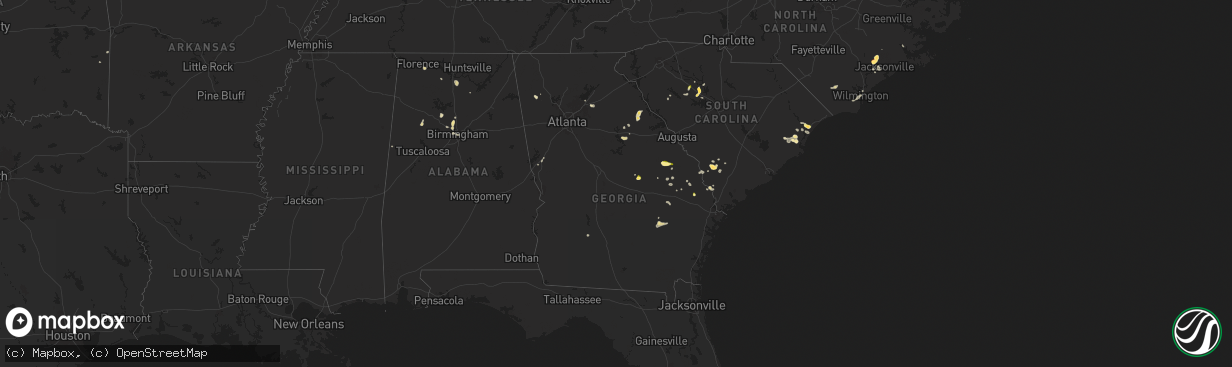
Hail Map in Georgia on April 23, 2025
The weather event in Georgia on April 23, 2025 includes Hail and Wind maps. 17 states and 530 cities were impacted and suffered possible damage. The total estimated number of properties impacted is 582.
Want more than just the map?
Turn this storm into a full workflow.
- Owner + property data so you know who to knock
- OnDemand branded weather history reports to win the "did we even have hail?" argument
- RoofTrace estimate so reps stop guessing numbers at the door
Bought this map? Upgrade within 7 days and we'll credit the $230. (10-15 min setup call)
Hail
Wind
582
Estimated number of impacted properties by a 1.00" hail or larger0
Estimated number of impacted properties by a 1.75" hail or larger0
Estimated number of impacted properties by a 2.50" hail or largerStorm reports in Georgia
Georgia
| Date | Description |
|---|---|
| 04/23/20254:30 PM CDT | Broadcast media relayed picture of a hail stone estimated to be the size of a quarter. |
| 04/23/20251:57 PM CDT | Burke county dispatch reports tree down over the road in the 2500 block of porter carswell rd. |
| 04/23/20251:38 PM CDT | Tree reported down at the intersection of 10th st nw and hemphill ave nw. |
| 04/23/20251:29 PM CDT | Burke county dispatch reported tree down on rosier rd in between highways 305 and 56. |
All States Impacted by Hail Map on April 23, 2025
Cities Impacted by Hail Map on April 23, 2025
- Sinton, TX
- Taft, TX
- Portland, TX
- Aransas Pass, TX
- Ingleside, TX
- Port Aransas, TX
- Morland, KS
- Spearville, KS
- Offerle, KS
- Wakeeney, KS
- Ellis, KS
- Sterling, KS
- Nickerson, KS
- Lyons, KS
- Ogallah, KS
- Hutchinson, KS
- Windom, KS
- Hill City, KS
- Mcpherson, KS
- Randolph, KS
- Lauderdale, MS
- Green, KS
- Winnabow, NC
- Blue Rapids, KS
- Louisville, GA
- Midville, GA
- Wrightsville, GA
- Waynesboro, GA
- Waterville, KS
- Clay Center, KS
- Leonardville, KS
- Meridian, MS
- East Dublin, GA
- Leland, NC
- Wilmington, NC
- Westmoreland, KS
- Dodson, LA
- Scooba, MS
- Fairfax, SC
- Barnes, KS
- Shuqualak, MS
- Olsburg, KS
- Millen, GA
- Holton, KS
- Lagrange, GA
- Brunson, SC
- Twin City, GA
- Mayetta, KS
- Jonesboro, LA
- Hazlehurst, MS
- Georgetown, MS
- Hampton, SC
- Swainsboro, GA
- Hogansville, GA
- Centralia, KS
- Hollenberg, KS
- Circleville, KS
- Tennille, GA
- Garfield, GA
- Odell, NE
- Diller, NE
- Amite, LA
- Hanover, KS
- Steele City, NE
- Birmingham, AL
- Greenleaf, KS
- Linn, KS
- Wymore, NE
- New Bern, NC
- Richlands, NC
- Maple Hill, NC
- Macon, MS
- Starkville, MS
- Palmer, KS
- Conway, SC
- Beulaville, NC
- Chinquapin, NC
- Beatrice, NE
- Blue Springs, NE
- Hughes, AR
- Brooksville, MS
- Mount Olive, AL
- Saint George, KS
- Cedarbluff, MS
- Washington, KS
- Morrowville, KS
- Virginia, NE
- White Plains, GA
- Berry, AL
- Andrews, SC
- Myrtle Beach, SC
- Sparta, GA
- Mantee, MS
- Woodland, MS
- Wamego, KS
- Brookside, AL
- Graysville, AL
- Gardendale, AL
- Proctor, AR
- Murrells Inlet, SC
- Haddam, KS
- Sylvania, GA
- Greensboro, GA
- Farmerville, LA
- Jasper, AL
- Cordova, AL
- Monteagle, TN
- Filley, NE
- Crab Orchard, NE
- Islandton, SC
- Somerville, AL
- Hartselle, AL
- West Monroe, LA
- Varnville, SC
- Hemingway, SC
- Georgetown, SC
- Ehrhardt, SC
- Carrollton, AL
- Jacksonville, NC
- Tellico Plains, TN
- Trenton, NC
- Warrior, AL
- Cottageville, SC
- Tryon, NE
- Stockton, MO
- Endicott, NE
- Carbon Hill, AL
- Tecumseh, NE
- Adams, NE
- Falkville, AL
- Sterling, NE
- Waynesboro, MS
- Kim, CO
- Soldier, KS
- Mahaska, KS
- Delia, KS
- Emmett, KS
- Saint Marys, KS
- El Dorado Springs, MO
- Delhi, LA
- Alma, KS
- Burr, NE
- Manhattan, KS
- Rayville, LA
- Paxico, KS
- Belvue, KS
- Oakley, KS
- Monument, KS
- Nebraska City, NE
- Holly, CO
- Union Point, GA
- Maple Hill, KS
- Dighton, KS
- Topeka, KS
- Moulton, AL
- Danville, AL
- Tribune, KS
- Washington, GA
- Winona, KS
- Cook, NE
- Hoyt, KS
- Hohenwald, TN
- Satanta, KS
- Sheridan Lake, CO
- Scott City, KS
- Eagle, NE
- Palmyra, NE
- Sharon Springs, KS
- Linden, TN
- Brooklet, GA
- Luray, SC
- Silver Lake, KS
- Rossville, KS
- Colby, KS
- Wallace, KS
- Syracuse, KS
- Arab, AL
- Thedford, NE
- Ulysses, KS
- Fort Stockton, TX
- Garnett, SC
- Tillman, SC
- Elmwood, NE
- Smithville, MS
- Carbondale, KS
- Tignall, GA
- Athens, TN
- Clyo, GA
- Pecos, TX
- Rayle, GA
- Percival, IA
- Wakarusa, KS
- Berryton, KS
- Garden City, KS
- Hodgen, OK
- Heavener, OK
- Taylorsville, GA
- Woodbury, TN
- Meriden, KS
- Overbrook, KS
- Fulton, MS
- Batesville, MS
- Marienthal, KS
- Pineland, SC
- Rome, GA
- Port Gibson, MS
- Hallsboro, NC
- Etowah, TN
- Englewood, TN
- Barstow, TX
- Pyote, TX
- Lake Waccamaw, NC
- Gruver, TX
- Ozawkie, KS
- Goodwell, OK
- Nevada, MO
- Emerson, IA
- Winder, GA
- Auburn, GA
- Leoti, KS
- Guymon, OK
- Auburn, KS
- Tecumseh, KS
- Rolla, KS
- Osage City, KS
- Courtland, MS
- Water Valley, MS
- Bolton, NC
- Oxford, MS
- Taylor, MS
- Council, NC
- Hereford, TX
- Kingston, GA
- Mentone, TX
- Lyndon, KS
- Wink, TX
- Kermit, TX
- Emporia, KS
- Audubon, IA
- Reading, KS
- Atlantic, IA
- Statesboro, GA
- Baxley, GA
- Scranton, KS
- Hamlin, IA
- Exira, IA
- Guthrie Center, IA
- Marne, IA
- Brayton, IA
- Adair, IA
- Spearman, TX
- Elmer, LA
- Buford, GA
- Lecompton, KS
- Perry, KS
- Dimmitt, TX
- Healy, KS
- Elizabeth, CO
- Franktown, CO
- Leighton, AL
- Cobbtown, GA
- Collins, GA
- Elbert, CO
- Jal, NM
- Marathon, TX
- Poteau, OK
- Melbourne, IA
- Rhodes, IA
- Lawrence, KS
- Melvern, KS
- Burlingame, KS
- Franklin, TN
- Marshalltown, IA
- Kiowa, CO
- Clutier, IA
- Traer, IA
- Dysart, IA
- Laurel, IA
- Newton, IA
- Hardesty, OK
- Ashland, MS
- Lebo, KS
- Newberry, SC
- Tama, IA
- Alpine, TX
- Channing, TX
- Hartley, TX
- Anita, IA
- Happy, TX
- Lakin, KS
- Sublette, KS
- Casey, IA
- Lyons, GA
- Hackett, AR
- Silverstreet, SC
- Holcomb, KS
- Calhan, CO
- Ramah, CO
- Garwin, IA
- Gladbrook, IA
- Simla, CO
- Kimballton, IA
- Greenwood, AR
- Huntington, AR
- Arapahoe, CO
- Hart, TX
- Quenemo, KS
- Muleshoe, TX
- Rockwell City, IA
- Eunice, NM
- Andrews, TX
- Agate, CO
- Carrollton, MS
- Admire, KS
- Bonner Springs, KS
- Sac City, IA
- Canyon, TX
- Garrison, IA
- Nazareth, TX
- Surrency, GA
- Nashville, TN
- Coon Rapids, IA
- Early, IA
- Cheyenne Wells, CO
- Tulia, TX
- Kinards, SC
- Moorland, IA
- Fort Dodge, IA
- Barnum, IA
- Clare, IA
- Somers, IA
- Matheson, CO
- Lake View, IA
- Afton, TX
- Deerfield, KS
- Seminole, TX
- Gove, KS
- Greenwood, MS
- Callender, IA
- Lytton, IA
- Auburn, IA
- Dalhart, TX
- Kit Carson, CO
- Scranton, IA
- Prosperity, SC
- Pomaria, SC
- Lake City, IA
- Limon, CO
- Farnhamville, IA
- Dumas, TX
- Bradford, IA
- Duncombe, IA
- Gowrie, IA
- Dickens, TX
- Winters, TX
- Seagraves, TX
- Edison, NE
- Roaring Springs, TX
- Pope, MS
- Garnett, KS
- Williamsburg, KS
- Waverly, KS
- Arapahoe, NE
- Oxford, NE
- Geneva, IA
- Hampton, IA
- Ackley, IA
- Iowa Falls, IA
- Hugo, CO
- Vincent, IA
- Plains, TX
- Denver City, TX
- Ottawa, KS
- Princeton, KS
- Wingate, TX
- Bristow, IA
- Richmond, KS
- Hooker, OK
- Rantoul, KS
- Ovalo, TX
- Allison, IA
- Ballinger, TX
- Sylvester, GA
- Walsh, CO
- Wellsburg, IA
- Blackwell, TX
- Tuscola, TX
- Grinnell, KS
- Paton, IA
- Cimarron, KS
- Coffeeville, MS
- Webster City, IA
- Sudan, TX
- Aplington, IA
- Arriba, CO
- Shell Rock, IA
- Beeler, KS
- New Hartford, IA
- Janesville, IA
- Cedar Falls, IA
- Sunray, TX
- Kress, TX
- Silverton, TX
- Elkhart, KS
- Cope, CO
- Karval, CO
- Flagler, CO
- Oelwein, IA
- Earth, TX
- Mcadoo, TX
- Lockney, TX
- Richfield, KS
- Ness City, KS
- Seibert, CO
- Johnson, KS
- Dryden, TX
- Ingalls, KS
- Quitaque, TX
- Clarendon, TX
- Turkey, TX
- Le Grand, IA
- Otis, CO
- Akron, CO
- Claude, TX
- Amarillo, TX
- Childress, TX
- Glen Haven, WI
- Cassville, WI
- Springlake, TX
- Spur, TX
- Flomot, TX
- Matador, TX
- Lancaster, WI
- Bloomington, WI
- Lakeview, TX
- Memphis, TX
- Plainview, TX
- Reliance, TN
- Dumont, IA
- Bagley, WI
- Eads, CO
- Weskan, KS
- Paducah, TX
- Jetmore, KS
- Ozona, TX
- Tell, TX
- Quanah, TX
- Hollis, OK
- Dodson, TX
- Girard, TX
- Wellington, TX
- Gould, OK
- Eldorado, OK
- Duke, OK
- Mangum, OK
- Sayre, OK
- Elk City, OK
- Toledo, IA
- Carter, OK
- Butler, OK
- Sonora, TX
- Crowell, TX
- Plains, KS
- Seymour, TX
- Meade, KS
- Cuba, KS
- Frederick, OK
- Tipton, OK
- Snyder, OK
- Ashland, KS
- Englewood, KS
- Fowler, KS
- Norton, TX
- Bronte, TX
- Munday, TX
- Goree, TX
- Chelsea, IA
- Brock, NE
- Elberon, IA
- Protection, KS
- Electra, TX
- Throckmorton, TX
- Voss, TX
- Valera, TX
- Coleman, TX
- Gouldbusk, TX
- Rocky Ford, GA
- Coldwater, KS
- Lodge, SC
- Barnwell, SC
- Uvalda, GA
- London, TX
- Santa Anna, TX
- Abilene, TX
- Mason, TX
- Brownwood, TX
- Early, TX
- Rising Star, TX
- Zephyr, TX
- Talmage, NE
- Sidney, IA
- Thurman, IA
- Hamburg, IA
- Avoca, TX
- Panora, IA
- Yale, IA
- Bagley, IA
- Bayard, IA
- Jamaica, IA
- Pierceville, KS
- Goldthwaite, TX
- San Saba, TX
- Alva, OK
- Breckenridge, TX
- Graham, TX
- Priddy, TX
- Mullin, TX
- Woodson, TX
- Pottsville, TX
- Hamilton, TX
- Gustine, TX
- Comanche, TX
- Little Mountain, SC
- Whitmire, SC
- Blair, SC
- Chapin, SC
- Greenwood, SC
- Pomona, KS
- Wellsville, KS
- Osawatomie, KS


