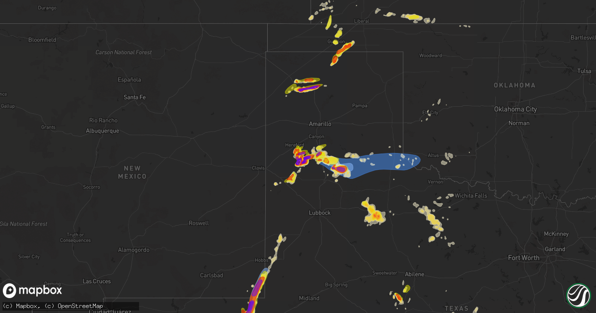
Hail Map on April 23, 2025
Get this storm
April 23 map
$229
one time, instant access
Download today. No call, no setup
Keep the $229
Bought the map and want the full workflow? Apply the entire $229 to a subscription within 7 days. None of it is wasted.
Every map, not just this one
This buys you this map. Subscription and you get every map we run, in the markets you choose from a few cities to whole states to nationwide. Plus real-time alerts the moment a storm fires.
Contact data
Name, contact info, occupancy, even credit band for addresses in the footprint. You go from where it hit to who to call.
Become the source they trust
Unlimited branding weather history reports on demand. You already have the documented answer ready for the property owner, and you are the one who showed up with it.
Property data and RoofTrace estimates
Pull up any address you have got, its value and the exact code rules for that jurisdiction, straight from One Click Code. Then RoofTrace estimates the squares, pitch, and roof value, priced the way you price.
States Impacted by Hail Map on April 23, 2025
Storm reports
Colorado
| Date | Description |
|---|---|
| 04/23/20256:43 PM CDT | Report from mping: quarter |
| 04/23/20256:23 PM CDT | A local report indicates 1.75 inch wind near 5 WNW Elbert |
| 04/22/20259:09 PM CDT | Mesonet station up711 7.7 nw boyero |
| 04/22/20259:09 PM CDT | Mesonet station up711 7.7 nw boyero |
| 04/22/20258:50 PM CDT | A local report indicates 1.00 inch wind near 2 W Limon |
| 04/22/20258:37 PM CDT | A local report indicates 1.75 inch wind near 10 S Limon |
| 04/22/20258:22 PM CDT | Asos station klic limon. |
| 04/22/20257:53 PM CDT | A local report indicates 2.50 inch wind near 1 E Matheson |
| 04/22/20257:48 PM CDT | Report from mping: hen egg |
| 04/22/20257:22 PM CDT | A local report indicates 1.50 inch wind near 9 ESE Fondis |
Tennessee
| Date | Description |
|---|---|
| 04/23/20255:05 PM CDT | Hail up to quarter size on hollis creek rd... Photos via social media. |
Alabama
| Date | Description |
|---|---|
| 04/23/20253:25 PM CDT | Mixed size hail in the morris area with the largest hailstones reaching quarter size. |
Mississippi
| Date | Description |
|---|---|
| 04/23/20253:02 PM CDT | A local report indicates 1.00 inch wind near 1 ESE Bigbee Valley |
Louisiana
| Date | Description |
|---|---|
| 04/23/20255:25 AM CDT | From personal weather station. |
| 04/23/20253:30 AM CDT | Fences down and chimney blown off house on fortune road in youngsville. Roof shingles blown off homes. Large tree limb and metal flashing in yard of one home. |
Oklahoma
| Date | Description |
|---|---|
| 04/23/20251:03 AM CDT | Measured at a personal weather station. |
| 04/22/20258:54 PM CDT | A local report indicates 1.25 inch wind near Guymon |
| 04/22/20258:20 PM CDT | Just under ping pong ball size. |
| 04/22/20258:10 PM CDT | A local report indicates 1.50 inch wind near Hardesty |
| 04/22/20258:01 PM CDT | A local report indicates 1.50 inch wind near Hardesty |
| 04/22/20257:56 PM CDT | A local report indicates 1.75 inch wind near Hardesty |
| 04/22/20257:51 PM CDT | Corrected hail size. |
| 04/22/20257:51 PM CDT | A local report indicates 1.00 inch wind near Hardesty |
South Carolina
| Date | Description |
|---|---|
| 04/23/20256:03 PM CDT | Hail up to quarter sized. Also 1 tree blocking a roadway. |
| 04/23/20254:00 PM CDT | A local report indicates 1.25 inch wind near 5 ENE Sampit |
| 04/23/20253:02 PM CDT | Reported from along bay road near socastee |
| 04/23/20253:00 PM CDT | Socastee boulevard. |
| 04/23/20252:48 PM CDT | Myrtle beach golf and yacht club. |
| 04/23/20252:08 PM CDT | Got numerous quarter sized hail stones... A few even as big as golf ball. Time estimated from radar. |
| 04/23/20251:47 PM CDT | Broadcast media relayed a picture of a tree down between brunson and fairfax. Time estimated from radar. |
| 04/22/20258:11 PM CDT | Newberry em reported golf ball size hail and emailed a photo large hail. |
| 04/22/20257:20 PM CDT | Social media post from a local greenhouse showing hail covering the ground. Owner estimated nickel to quarter size hail and damage to the property. |
Iowa
| Date | Description |
|---|---|
| 04/23/20256:55 PM CDT | Wind gusts up to 60 mph and nickel sized hail. This occurred along a 2-3 mile area center on this location. |
| 04/23/20256:39 PM CDT | A local report indicates 1.00 inch wind near 2 W Marshalltown |
| 04/23/20256:38 PM CDT | Report from mping: quarter |
| 04/23/20256:37 PM CDT | Nickel to quarter sized hail. Ground becoming mostly covered. |
| 04/23/20256:37 PM CDT | Report from mping: quarter |
| 04/23/20256:36 PM CDT | Ping pong hail near highway 44 and cherry avenue. Relayed via emergency management. |
| 04/23/20256:01 PM CDT | Report from mping: quarter |
| 04/22/20257:52 PM CDT | Report from mping: ping pong ball |
| 04/22/20257:49 PM CDT | Reported by trained spotter. |
| 04/22/20257:43 PM CDT | A local report indicates 1.00 inch wind near 2 N Fort Dodge |
| 04/22/20257:43 PM CDT | Nickel to quarter sized hail in fort dodge. |
| 04/22/20257:40 PM CDT | Measured with calipers. |
| 04/22/20257:39 PM CDT | Report from mping: quarter |
| 04/22/20257:38 PM CDT | Up to quarter sized hail but most was smaller. Hail lasted from 7:38 pm to 7:42 pm. |
| 04/22/20257:00 PM CDT | Relayed by kwwl tv. Hail ranged from pear to ping pong ball. |
| 04/22/20257:00 PM CDT | Corrects previous hail report from dysart. Relayed by kwwl tv. Hail ranged from pear to ping pong ball. |
North Carolina
| Date | Description |
|---|---|
| 04/23/20255:50 PM CDT | Tree down along hwy 87 near east acadia. |
| 04/23/20253:07 PM CDT | Hail of half dollar to ping pong ball size falling right now. Leaves being stripped by the hail. Hail is beginning to accumulate. |
| 04/23/20252:52 PM CDT | Delayed report. Golf ball size hail reported in the back swamp area near the richlands airport. Report via facebook. |
| 04/23/20252:52 PM CDT | Delayed report. Wcti relayed a report of golf ball size hail. Location and time estimated based on radar. |
| 04/23/20252:52 PM CDT | Delayed report. Richlands airport police reported hail damage to vehicles and buildings at the airport. Hail was estimated to be half dollar or larger. Time estimated b |
| 04/23/20252:45 PM CDT | Delayed report. Hail damaged trees... Vehicles... And a camper. The picture submitted via facebook suggests the hail was at least half dollar to golf ball size. A signi |
Kansas
| Date | Description |
|---|---|
| 04/23/20256:40 PM CDT | Social media picture showing quarter size hail. |
| 04/23/20256:15 PM CDT | Video showing at least quarter-sized hail sent via social media. |
| 04/23/20256:15 PM CDT | Pictures from social media show 2 inch hail in garden city. |
| 04/23/20256:12 PM CDT | Report from mping: half dollar |
| 04/23/20256:11 PM CDT | A local report indicates 1.00 inch wind near 3 NW Manning |
| 04/23/20256:08 PM CDT | A local report indicates 1.00 inch wind near Healy |
| 04/23/20255:46 PM CDT | A local report indicates 1.00 inch wind near 1 WSW Osage City |
| 04/23/20255:45 PM CDT | Social media report of penny to quarter size hail 2 miles southwest of downtown garden city. |
| 04/23/20255:27 PM CDT | A local report indicates 1.00 inch wind near 4 NNE Berryton |
| 04/23/20255:25 PM CDT | A local report indicates 1.00 inch wind near Winona |
| 04/23/20255:25 PM CDT | A local report indicates 1.00 inch wind near 2 NE Berryton |
| 04/23/20255:12 PM CDT | M ping report. |
| 04/23/20255:10 PM CDT | A local report indicates 1.00 inch wind near 4 WSW Plymell |
| 04/23/20255:10 PM CDT | Greeley county dispatch relayed a report of golf ball sized hail near the kansas/ colorado border. Estimated time of occurrence 4:10 pm mdt |
| 04/23/20255:08 PM CDT | Report from mping: golf ball |
| 04/23/20255:05 PM CDT | Hail up to 2 inches in diameter covering the ground. |
| 04/23/20255:05 PM CDT | A local report indicates 2.00 inch wind near Scott City |
| 04/23/20255:04 PM CDT | Just slightly over golf ball. |
| 04/23/20255:00 PM CDT | A local report indicates 60 MPH wind near 3 NW Perry |
| 04/23/20255:00 PM CDT | Just over 2 inches. |
| 04/23/20254:56 PM CDT | Off-duty nws employee reported half-dollar sized hail 2 miles south of scott city. |
| 04/23/20254:54 PM CDT | Winds blew windows out of garage. |
| 04/23/20254:53 PM CDT | A local report indicates 1.25 inch wind near Hoyt |
| 04/23/20254:52 PM CDT | A local report indicates 1.25 inch wind near 2 SW Shields |
| 04/23/20254:52 PM CDT | Picture of quarter-sized hail sent to us via slack from county emergency manager. |
| 04/23/20254:43 PM CDT | Spotter estimated pea to quarter size hail at 3:43 pm mdt. |
| 04/23/20254:30 PM CDT | Delayed report of golf ball sized hail at the junction between highway 40 and highway 25 north at 3:30 pm mdt. |
| 04/23/20252:59 PM CDT | Report from mping: quarter |
| 04/23/20252:52 PM CDT | A local report indicates 1.00 inch wind near 6 SSE Saint George |
| 04/23/20252:18 PM CDT | A local report indicates 1.00 inch wind near 2 E Holton |
| 04/23/202511:22 AM CDT | Quarter size hail covering the ground. |
| 04/23/202510:30 AM CDT | . |
| 04/22/20259:30 PM CDT | Pws-kksholco17. |
| 04/22/20258:37 PM CDT | Delayed report from social media of 2 inch diameter hail. |
| 04/22/20257:08 PM CDT | A local report indicates 1.50 inch wind near Healy |
| 04/22/20257:03 PM CDT | A local report indicates 1.00 inch wind near Garden City |
Texas
| Date | Description |
|---|---|
| 04/23/20256:20 PM CDT | Video sent on social media of a few inches of accumulated hail with the largest hailstone around the size of a quarter. |
| 04/23/20255:20 PM CDT | A local report indicates 1.00 inch wind near Barstow |
| 04/23/20255:17 PM CDT | Picture of hail sent with hail size ranging from half dollar to golf ball size. |
| 04/23/20254:58 PM CDT | A local report indicates 1.00 inch wind near 8 E Toyah Lake |
| 04/23/202511:56 AM CDT | At 11:56 pm kcds measured a wind gusts of 60 mph. |
| 04/23/20258:07 AM CDT | Report found on social media. Time of report was estimated based on radar. |
| 04/23/202512:13 AM CDT | Childress 2nne measured a wind gusts of 64 mph... Following the 12:09 am gusts of 60 mph. |
| 04/23/202512:09 AM CDT | Wtm childress 2nne measured 60 mph. |
| 04/22/202511:56 PM CDT | Corrects previous tstm wnd gst report from 4 w childress. At 11:56 pm kcds measured a wind gusts of 60 mph. Corrected. |
| 04/22/202510:20 PM CDT | A local report indicates 60 MPH wind near Caprock Canyons State P |
| 04/22/202510:09 PM CDT | A local report indicates 79 MPH wind near 7 ESE Silverton |
| 04/22/202510:08 PM CDT | A local report indicates 59 MPH wind near 3 ENE South Plains |
| 04/22/20258:52 PM CDT | Person on facebook reporting half dollar size hail near ovalo. |
| 04/22/20258:49 PM CDT | Emergency manager lost their windshield due to hail. |
| 04/22/20258:49 PM CDT | Windows were blown out of patrol units due to the hail. |
| 04/22/20258:47 PM CDT | A local report indicates 1.50 inch wind near Dumas |
| 04/22/20258:44 PM CDT | 61 mph wind gust occurred at 8:09 pm followed by a 63 mph wind gust at 8:11 pm. |
| 04/22/20258:40 PM CDT | A local report indicates 76 MPH wind near 2 ENE Tulia |
| 04/22/20258:26 PM CDT | Mostly 3/4 to 1 inch hail with some golf ball size hail. |
| 04/22/20258:22 PM CDT | Total of 5 minutes of severe gusts. |
| 04/22/20258:12 PM CDT | Report from mping: tennis ball |
| 04/22/20258:11 PM CDT | 61 mph wind gust occurred at 8:09 pm followed by a 63 mph wind gust at 8:11 pm. |
| 04/22/20258:09 PM CDT | A local report indicates 61 MPH wind near 9 NNE Sunray |
| 04/22/20257:36 PM CDT | Picture sent via social media. |
| 04/22/20257:35 PM CDT | A local report indicates 59 MPH wind near 2 N Stinnett |
| 04/22/20257:32 PM CDT | A local report indicates 1.75 inch wind near Dimmitt |
| 04/22/20257:32 PM CDT | Report from mping: baseball++ |
| 04/22/20257:23 PM CDT | Via live stream. |
| 04/22/20257:01 PM CDT | Picture submitted via social media. |
New Mexico
| Date | Description |
|---|---|
| 04/23/20256:50 PM CDT | Corrects timing of previous hail report from 4 n jal. |
| 04/23/20256:30 PM CDT | A local report indicates 58 MPH wind near 4 NW Bennett |
| 04/22/20257:29 PM CDT | A local report indicates 1.25 inch wind near 7 E Eunice |
| 04/22/20257:20 PM CDT | A local report indicates 1.75 inch wind near 4 N Jal |
| 04/22/20257:18 PM CDT | A local report indicates 1.00 inch wind near 5 E Eunice |
| 04/22/20257:15 PM CDT | A local report indicates 1.50 inch wind near 9 S Eunice |
| 04/22/20257:09 PM CDT | A local report indicates 1.00 inch wind near 7 N Jal |
Georgia
| Date | Description |
|---|---|
| 04/23/20254:30 PM CDT | Broadcast media relayed picture of a hail stone estimated to be the size of a quarter. |
| 04/23/20251:57 PM CDT | Burke county dispatch reports tree down over the road in the 2500 block of porter carswell rd. |
| 04/23/20251:38 PM CDT | Tree reported down at the intersection of 10th st nw and hemphill ave nw. |
| 04/23/20251:29 PM CDT | Burke county dispatch reported tree down on rosier rd in between highways 305 and 56. |
Nebraska
| Date | Description |
|---|---|
| 04/23/20254:15 PM CDT | Awos station kafk nebraska city airport. |
| 04/23/20254:10 PM CDT | A local report indicates 1.00 inch wind near Cook |
| 04/22/20258:00 PM CDT | Wide variety of sizes from pea up to quarter to half dollar size. |
| 04/22/20257:56 PM CDT | Delayed report. Time estimated from radar. Marble to quarter sized hail. |
Cities Impacted by Hail Map on April 23, 2025
- Sinton, TX
- Taft, TX
- Portland, TX
- Aransas Pass, TX
- Ingleside, TX
- Port Aransas, TX
- Morland, KS
- Spearville, KS
- Offerle, KS
- Wakeeney, KS
- Ellis, KS
- Sterling, KS
- Nickerson, KS
- Lyons, KS
- Ogallah, KS
- Hutchinson, KS
- Windom, KS
- Hill City, KS
- Mcpherson, KS
- Randolph, KS
- Lauderdale, MS
- Green, KS
- Winnabow, NC
- Blue Rapids, KS
- Louisville, GA
- Midville, GA
- Wrightsville, GA
- Waynesboro, GA
- Waterville, KS
- Clay Center, KS
- Leonardville, KS
- Meridian, MS
- East Dublin, GA
- Leland, NC
- Wilmington, NC
- Westmoreland, KS
- Dodson, LA
- Scooba, MS
- Fairfax, SC
- Barnes, KS
- Shuqualak, MS
- Olsburg, KS
- Millen, GA
- Holton, KS
- Lagrange, GA
- Brunson, SC
- Twin City, GA
- Mayetta, KS
- Jonesboro, LA
- Hazlehurst, MS
- Georgetown, MS
- Hampton, SC
- Swainsboro, GA
- Hogansville, GA
- Centralia, KS
- Hollenberg, KS
- Circleville, KS
- Tennille, GA
- Garfield, GA
- Odell, NE
- Diller, NE
- Amite, LA
- Hanover, KS
- Steele City, NE
- Birmingham, AL
- Greenleaf, KS
- Linn, KS
- Wymore, NE
- New Bern, NC
- Richlands, NC
- Maple Hill, NC
- Macon, MS
- Starkville, MS
- Palmer, KS
- Conway, SC
- Beulaville, NC
- Chinquapin, NC
- Beatrice, NE
- Blue Springs, NE
- Hughes, AR
- Brooksville, MS
- Mount Olive, AL
- Saint George, KS
- Cedarbluff, MS
- Washington, KS
- Morrowville, KS
- Virginia, NE
- White Plains, GA
- Berry, AL
- Andrews, SC
- Myrtle Beach, SC
- Sparta, GA
- Mantee, MS
- Woodland, MS
- Wamego, KS
- Brookside, AL
- Graysville, AL
- Gardendale, AL
- Proctor, AR
- Murrells Inlet, SC
- Haddam, KS
- Sylvania, GA
- Greensboro, GA
- Farmerville, LA
- Jasper, AL
- Cordova, AL
- Monteagle, TN
- Filley, NE
- Crab Orchard, NE
- Islandton, SC
- Somerville, AL
- Hartselle, AL
- West Monroe, LA
- Varnville, SC
- Hemingway, SC
- Georgetown, SC
- Ehrhardt, SC
- Carrollton, AL
- Jacksonville, NC
- Tellico Plains, TN
- Trenton, NC
- Warrior, AL
- Cottageville, SC
- Tryon, NE
- Stockton, MO
- Endicott, NE
- Carbon Hill, AL
- Tecumseh, NE
- Adams, NE
- Falkville, AL
- Sterling, NE
- Waynesboro, MS
- Kim, CO
- Soldier, KS
- Mahaska, KS
- Delia, KS
- Emmett, KS
- Saint Marys, KS
- El Dorado Springs, MO
- Delhi, LA
- Alma, KS
- Burr, NE
- Manhattan, KS
- Rayville, LA
- Paxico, KS
- Belvue, KS
- Oakley, KS
- Monument, KS
- Nebraska City, NE
- Holly, CO
- Union Point, GA
- Maple Hill, KS
- Dighton, KS
- Topeka, KS
- Moulton, AL
- Danville, AL
- Tribune, KS
- Washington, GA
- Winona, KS
- Cook, NE
- Hoyt, KS
- Hohenwald, TN
- Satanta, KS
- Sheridan Lake, CO
- Scott City, KS
- Eagle, NE
- Palmyra, NE
- Sharon Springs, KS
- Linden, TN
- Brooklet, GA
- Luray, SC
- Silver Lake, KS
- Rossville, KS
- Colby, KS
- Wallace, KS
- Syracuse, KS
- Arab, AL
- Thedford, NE
- Ulysses, KS
- Fort Stockton, TX
- Garnett, SC
- Tillman, SC
- Elmwood, NE
- Smithville, MS
- Carbondale, KS
- Tignall, GA
- Athens, TN
- Clyo, GA
- Pecos, TX
- Rayle, GA
- Percival, IA
- Wakarusa, KS
- Berryton, KS
- Garden City, KS
- Hodgen, OK
- Heavener, OK
- Taylorsville, GA
- Woodbury, TN
- Meriden, KS
- Overbrook, KS
- Fulton, MS
- Batesville, MS
- Marienthal, KS
- Pineland, SC
- Rome, GA
- Port Gibson, MS
- Hallsboro, NC
- Etowah, TN
- Englewood, TN
- Barstow, TX
- Pyote, TX
- Lake Waccamaw, NC
- Gruver, TX
- Ozawkie, KS
- Goodwell, OK
- Nevada, MO
- Emerson, IA
- Winder, GA
- Auburn, GA
- Leoti, KS
- Guymon, OK
- Auburn, KS
- Tecumseh, KS
- Rolla, KS
- Osage City, KS
- Courtland, MS
- Water Valley, MS
- Bolton, NC
- Oxford, MS
- Taylor, MS
- Council, NC
- Hereford, TX
- Kingston, GA
- Mentone, TX
- Lyndon, KS
- Wink, TX
- Kermit, TX
- Emporia, KS
- Audubon, IA
- Reading, KS
- Atlantic, IA
- Statesboro, GA
- Baxley, GA
- Scranton, KS
- Hamlin, IA
- Exira, IA
- Guthrie Center, IA
- Marne, IA
- Brayton, IA
- Adair, IA
- Spearman, TX
- Elmer, LA
- Buford, GA
- Lecompton, KS
- Perry, KS
- Dimmitt, TX
- Healy, KS
- Elizabeth, CO
- Franktown, CO
- Leighton, AL
- Cobbtown, GA
- Collins, GA
- Elbert, CO
- Jal, NM
- Marathon, TX
- Poteau, OK
- Melbourne, IA
- Rhodes, IA
- Lawrence, KS
- Melvern, KS
- Burlingame, KS
- Franklin, TN
- Marshalltown, IA
- Kiowa, CO
- Clutier, IA
- Traer, IA
- Dysart, IA
- Laurel, IA
- Newton, IA
- Hardesty, OK
- Ashland, MS
- Lebo, KS
- Newberry, SC
- Tama, IA
- Alpine, TX
- Channing, TX
- Hartley, TX
- Anita, IA
- Happy, TX
- Lakin, KS
- Sublette, KS
- Casey, IA
- Lyons, GA
- Hackett, AR
- Silverstreet, SC
- Holcomb, KS
- Calhan, CO
- Ramah, CO
- Garwin, IA
- Gladbrook, IA
- Simla, CO
- Kimballton, IA
- Greenwood, AR
- Huntington, AR
- Arapahoe, CO
- Hart, TX
- Quenemo, KS
- Muleshoe, TX
- Rockwell City, IA
- Eunice, NM
- Andrews, TX
- Agate, CO
- Carrollton, MS
- Admire, KS
- Bonner Springs, KS
- Sac City, IA
- Canyon, TX
- Garrison, IA
- Nazareth, TX
- Surrency, GA
- Nashville, TN
- Coon Rapids, IA
- Early, IA
- Cheyenne Wells, CO
- Tulia, TX
- Kinards, SC
- Moorland, IA
- Fort Dodge, IA
- Barnum, IA
- Clare, IA
- Somers, IA
- Matheson, CO
- Lake View, IA
- Afton, TX
- Deerfield, KS
- Seminole, TX
- Gove, KS
- Greenwood, MS
- Callender, IA
- Lytton, IA
- Auburn, IA
- Dalhart, TX
- Kit Carson, CO
- Scranton, IA
- Prosperity, SC
- Pomaria, SC
- Lake City, IA
- Limon, CO
- Farnhamville, IA
- Dumas, TX
- Bradford, IA
- Duncombe, IA
- Gowrie, IA
- Dickens, TX
- Winters, TX
- Seagraves, TX
- Edison, NE
- Roaring Springs, TX
- Pope, MS
- Garnett, KS
- Williamsburg, KS
- Waverly, KS
- Arapahoe, NE
- Oxford, NE
- Geneva, IA
- Hampton, IA
- Ackley, IA
- Iowa Falls, IA
- Hugo, CO
- Vincent, IA
- Plains, TX
- Denver City, TX
- Ottawa, KS
- Princeton, KS
- Wingate, TX
- Bristow, IA
- Richmond, KS
- Hooker, OK
- Rantoul, KS
- Ovalo, TX
- Allison, IA
- Ballinger, TX
- Sylvester, GA
- Walsh, CO
- Wellsburg, IA
- Blackwell, TX
- Tuscola, TX
- Grinnell, KS
- Paton, IA
- Cimarron, KS
- Coffeeville, MS
- Webster City, IA
- Sudan, TX
- Aplington, IA
- Arriba, CO
- Shell Rock, IA
- Beeler, KS
- New Hartford, IA
- Janesville, IA
- Cedar Falls, IA
- Sunray, TX
- Kress, TX
- Silverton, TX
- Elkhart, KS
- Cope, CO
- Karval, CO
- Flagler, CO
- Oelwein, IA
- Earth, TX
- Mcadoo, TX
- Lockney, TX
- Richfield, KS
- Ness City, KS
- Seibert, CO
- Johnson, KS
- Dryden, TX
- Ingalls, KS
- Quitaque, TX
- Clarendon, TX
- Turkey, TX
- Le Grand, IA
- Otis, CO
- Akron, CO
- Claude, TX
- Amarillo, TX
- Childress, TX
- Glen Haven, WI
- Cassville, WI
- Springlake, TX
- Spur, TX
- Flomot, TX
- Matador, TX
- Lancaster, WI
- Bloomington, WI
- Lakeview, TX
- Memphis, TX
- Plainview, TX
- Reliance, TN
- Dumont, IA
- Bagley, WI
- Eads, CO
- Weskan, KS
- Paducah, TX
- Jetmore, KS
- Ozona, TX
- Tell, TX
- Quanah, TX
- Hollis, OK
- Dodson, TX
- Girard, TX
- Wellington, TX
- Gould, OK
- Eldorado, OK
- Duke, OK
- Mangum, OK
- Sayre, OK
- Elk City, OK
- Toledo, IA
- Carter, OK
- Butler, OK
- Sonora, TX
- Crowell, TX
- Plains, KS
- Seymour, TX
- Meade, KS
- Cuba, KS
- Frederick, OK
- Tipton, OK
- Snyder, OK
- Ashland, KS
- Englewood, KS
- Fowler, KS
- Norton, TX
- Bronte, TX
- Munday, TX
- Goree, TX
- Chelsea, IA
- Brock, NE
- Elberon, IA
- Protection, KS
- Electra, TX
- Throckmorton, TX
- Voss, TX
- Valera, TX
- Coleman, TX
- Gouldbusk, TX
- Rocky Ford, GA
- Coldwater, KS
- Lodge, SC
- Barnwell, SC
- Uvalda, GA
- London, TX
- Santa Anna, TX
- Abilene, TX
- Mason, TX
- Brownwood, TX
- Early, TX
- Rising Star, TX
- Zephyr, TX
- Talmage, NE
- Sidney, IA
- Thurman, IA
- Hamburg, IA
- Avoca, TX
- Panora, IA
- Yale, IA
- Bagley, IA
- Bayard, IA
- Jamaica, IA
- Pierceville, KS
- Goldthwaite, TX
- San Saba, TX
- Alva, OK
- Breckenridge, TX
- Graham, TX
- Priddy, TX
- Mullin, TX
- Woodson, TX
- Pottsville, TX
- Hamilton, TX
- Gustine, TX
- Comanche, TX
- Little Mountain, SC
- Whitmire, SC
- Blair, SC
- Chapin, SC
- Greenwood, SC
- Pomona, KS
- Wellsville, KS
- Osawatomie, KS