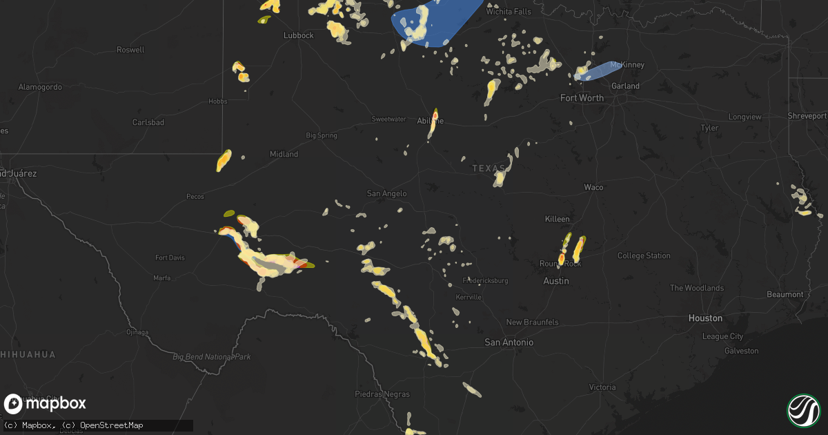
Hail Map in Texas on April 22, 2025
Get this storm
April 22 map
$229
one time, instant access
Download today. No call, no setup
Keep the $229
Bought the map and want the full workflow? Apply the entire $229 to a subscription within 7 days. None of it is wasted.
Every map, not just this one
This buys you this map. Subscription and you get every map we run, in the markets you choose from a few cities to whole states to nationwide. Plus real-time alerts the moment a storm fires.
Contact data
Name, contact info, occupancy, even credit band for addresses in the footprint. You go from where it hit to who to call.
Become the source they trust
Unlimited branding weather history reports on demand. You already have the documented answer ready for the property owner, and you are the one who showed up with it.
Property data and RoofTrace estimates
Pull up any address you have got, its value and the exact code rules for that jurisdiction, straight from One Click Code. Then RoofTrace estimates the squares, pitch, and roof value, priced the way you price.
Storm reports in Texas
Texas
| Date | Description |
|---|---|
| 04/22/20256:46 PM CDT | Public report via facebook. Time estimated via radar. |
| 04/22/20256:38 PM CDT | Hail measured with measuring tape. Several images of quarter to egg sized hail stones. |
| 04/22/20256:15 PM CDT | Hail up to and potentially in excess of 2㢠on us-285 se of fort stockton... Tx. |
| 04/22/20256:15 PM CDT | Hail up to and potentially in excess of 2â on us-285 se of fort stockton... Tx. |
| 04/22/20256:13 PM CDT | Corrects previous hail report from 6 n littlefield. Reported location was us385 and fm37 |
| 04/22/20256:13 PM CDT | Corrects previous hail report from 6 n littlefield. Reported location was us385 and fm37 |
| 04/22/20256:04 PM CDT | West texas mesonet report |
| 04/22/20256:02 PM CDT | Estimated from chaser video at brice. |
| 04/22/20255:40 PM CDT | 18 wheeler flipped over due to the winds 10 miles south of fort stockton on hwy 285. Time is approximate. |
| 04/22/20255:30 PM CDT | Report from mping: golf ball |
| 04/22/20255:25 PM CDT | Hockley county spotter. |
| 04/22/20254:55 PM CDT | Roof torn off and canopy shed displaced. |
| 04/22/20254:53 PM CDT | Asos station kfst fort stockton. |
| 04/22/20254:51 PM CDT | A local report indicates 1.00 inch wind near 11 S Clarendon |
| 04/22/20254:40 PM CDT | [landspout] pecos county emergency manager reported ping pong sized hail and heavy rain north of ft. Stockton on hwy 18. |
| 04/22/20254:30 PM CDT | [landspout] landspout reported by storm chaser over an open field for a few minutes. |
| 04/22/20254:21 PM CDT | Report from mping: ping pong ball |
| 04/22/20254:20 PM CDT | Report from mping: ping pong ball |
| 04/22/20254:17 PM CDT | Ping pong ball sized hail reported by chaser freddy mckinney. |
| 04/22/20254:06 PM CDT | Mping report of one inch diameter hail. |
| 04/22/20254:01 PM CDT | Report from mping: quarter |
| 04/22/20253:56 PM CDT | Trained spotter reported 1 inch hail 4 miles west of clarendon on us-287. |
| 04/22/20253:45 PM CDT | Estimated 1.5 inch hail in hail core roughly 15-20 miles north of fort stockton by storm chaser bill reed. |
| 04/22/20255:29 AM CDT | 15 foot down tree around legacy and warren dr in frisco. Radar estimated time. |
| 04/22/20255:27 AM CDT | Cwop w5lrk le in little elm reported 65 mph winds. |
| 04/22/20254:51 AM CDT | Report from mping: quarter |
| 04/22/20254:44 AM CDT | Report from mping: quarter |
| 04/22/20254:04 AM CDT | Report from mping: quarter |
| 04/22/20252:21 AM CDT | Structural damage to a building... Tree line damage... Billboards damaged... And several agriculture water pivots overturned. Radar analysis is consistent with a microb |
| 04/22/20252:17 AM CDT | Ping pong to golf ball size estimated but may have been larger as the hail stones had melted before retrieving. Several windows busted out of residence. Time estimated |
| 04/22/202512:17 AM CDT | A local report indicates 59 MPH wind near Doole |
| 04/21/202511:55 PM CDT | A personal weather station in benjamin measured a 60 mph wind gust. |
| 04/21/202510:34 PM CDT | Estimated wind gusts were 70-80 mph. |
| 04/21/202510:20 PM CDT | Slack message and picture confirmed. |
| 04/21/202510:15 PM CDT | Time estimated from radar. |
| 04/21/202510:15 PM CDT | Time estimated from radar. |
| 04/21/20259:40 PM CDT | Report from mping: half dollar |
| 04/21/20259:39 PM CDT | Quarter size hail was reported at lytle lake in abilene. |
| 04/21/20259:14 PM CDT | 2 miles north of the kgrk radar and on cr 357. Time estimated via radar. |
| 04/21/20259:09 PM CDT | Report from mping. |
| 04/21/20258:58 PM CDT | Hail up to 1.5 inches in diameter between taylor and granger/granger dam area; time estimated via radar. |
| 04/21/20258:57 PM CDT | Corrects previous hail report from 5 s weir. Report from mping. |
| 04/21/20258:50 PM CDT | Hockley county storm spotter reported accumulating golf ball size hail covering the highway. |
| 04/21/20258:50 PM CDT | Reported by floyd so. |
| 04/21/20258:50 PM CDT | Hockley county storm spotter reported accumulating golf ball size hail covering the highway. |
| 04/21/20258:50 PM CDT | Reported by floyd so. |
| 04/21/20258:42 PM CDT | A local report indicates 1.50 inch wind near 3 SW Weir |
| 04/21/20258:41 PM CDT | Corrects previous hail report from 5 s weir. Report from mping. |
| 04/21/20258:41 PM CDT | Report from mping. |
| 04/21/20258:40 PM CDT | A local report indicates 2.50 inch wind near 3 N Littlefield |
| 04/21/20258:40 PM CDT | A local report indicates 1.00 inch wind near 4 NNW Round Rock |
| 04/21/20258:38 PM CDT | Report from mping. |
| 04/21/20258:35 PM CDT | Along arabian colt drive in georgetown. |
| 04/21/20258:35 PM CDT | Report via spotter network. |
| 04/21/20258:35 PM CDT | Report via spotter network. |
| 04/21/20258:34 PM CDT | Picture of a hail stone measured using a digital caliper at intersection of fm 1460 and inner loop on social media. Time estimated via radar. |
| 04/21/20258:30 PM CDT | Nws employee reported baseball sized hail along us hwy 285. Time is approximate. |
| 04/21/20258:30 PM CDT | A local report indicates 1.38 inch wind near 4 SSE Georgetown |
| 04/21/20258:29 PM CDT | Intersection of cr 110 and limmer loop. Time estimated via radar. |
| 04/21/20258:28 PM CDT | Report from mping. |
| 04/21/20258:26 PM CDT | Storm chaser reported walnut sized hail along us hwy 285. |
| 04/21/20258:25 PM CDT | Intersection of paloma lake blvd and diego drive. Time estimated via radar. |
| 04/21/20258:22 PM CDT | Social media picture of tennis ball size hail in the teravista neighborhood to the south of georgetown. Time estimated via radar. |
| 04/21/20258:03 PM CDT | As per the pecos county emergency manager... Multiple power lines down in town |
| 04/21/20258:03 PM CDT | As per the pecos county emergency manager... Multiple power lines down in town with approximately 2...200 customers affected. Minor roof damage from wind and hail and r |
| 04/21/20257:59 PM CDT | Report from mping: golf ball |
| 04/21/20257:43 PM CDT | Storm chaser reported roughly golf ball sized hail along hwy 285. |
| 04/21/20257:38 PM CDT | Relayed via local media. |
| 04/21/20257:36 PM CDT | Storm chaser reported golf ball sized hail along us hwy 285. |
| 04/21/20257:35 PM CDT | 5 downed powerlines split near the base and an overturned 18 wheeler due to strong winds in the vicinity of a thunderstorm. |
| 04/21/20257:35 PM CDT | Report via x/twitter. |
| 04/21/20257:31 PM CDT | Report from mping: quarter |
| 04/21/20257:13 PM CDT | Public report relayed through local media. |
| 04/21/20257:05 PM CDT | Corrects previous tstm wnd dmg report from 4 ne odessa. 6 downed power poles split near the base... An overturned semi-trailer truck... And a broken stop sign due to st |
| 04/21/20257:04 PM CDT | Midland asos reported a peak wind gust of 97kts from a dry microburst associated with a weakening thunderstorm. Damage nearby supports the validity of this wind gust... |
All States Impacted by Hail Map on April 22, 2025
Cities Impacted by Hail Map on April 22, 2025
- Palmetto, LA
- Washington, LA
- Deville, LA
- Port Barre, LA
- Glenmora, LA
- Forest Hill, LA
- Randleman, NC
- Asheboro, NC
- Sophia, NC
- Franklinville, NC
- Newhebron, MS
- Climax, NC
- Liberty, NC
- Staley, NC
- Macon, NC
- Warrenton, NC
- Center Point, LA
- Effie, LA
- Kiln, MS
- Sanford, NC
- Siler City, NC
- Broadway, NC
- Snow Camp, NC
- Jackson Springs, NC
- Candor, NC
- Jonesville, LA
- Littleton, NC
- Prentiss, MS
- Ovett, MS
- Ellisville, MS
- Ville Platte, LA
- Macon, MS
- Brooksville, MS
- Ramseur, NC
- Mount Olive, MS
- Pittsboro, NC
- Trinity, NC
- Cheneyville, LA
- Marksville, LA
- Shuqualak, MS
- Childersburg, AL
- Lumberton, MS
- Gaston, NC
- Port Allen, LA
- Baton Rouge, LA
- Baker, LA
- Bunkie, LA
- Union, SC
- Whitmire, SC
- Carlisle, SC
- Dermott, AR
- Graham, NC
- Chapel Hill, NC
- Dry Prong, LA
- Colfax, LA
- Alpine, AL
- Sieper, LA
- Chester, SC
- Petal, MS
- Zachary, LA
- Boyce, LA
- Otis, LA
- Transylvania, LA
- Evergreen, LA
- Wilmar, AR
- Lake Village, AR
- Rayville, LA
- Cottonport, LA
- Morrow, LA
- Durham, NC
- Apex, NC
- Cary, NC
- Morrisville, NC
- Fort Stockton, TX
- Yates City, IL
- Aliceville, AL
- Monticello, AR
- Saint Landry, LA
- Plaucheville, LA
- Talladega, AL
- Pell City, AL
- Raleigh, NC
- Claude, TX
- Imperial, TX
- Delhi, LA
- Moselle, MS
- Fountain Hill, AR
- Farmington, IL
- Elmwood, IL
- Lincoln, AL
- Clarendon, TX
- Richburg, SC
- Fort Lawn, SC
- Newsoms, VA
- Boykins, VA
- Scooba, MS
- Emelle, AL
- Lizella, GA
- Natchez, LA
- Lena, LA
- Provencal, LA
- Eupora, MS
- Franklin, VA
- Utica, MS
- Wake Forest, NC
- Wendell, NC
- Zebulon, NC
- Littlefield, TX
- Sunset, LA
- Carencro, LA
- Macon, GA
- Cloutierville, LA
- Uniontown, AL
- Amherst, TX
- Boligee, AL
- Arnaudville, LA
- Suffolk, VA
- Hazlehurst, MS
- Eunice, LA
- Tulia, TX
- Kress, TX
- Anacoco, LA
- Olton, TX
- Plainview, TX
- Hale Center, TX
- Opelousas, LA
- Church Point, LA
- Lakeview, TX
- Cameron, NC
- Eutaw, AL
- Mantee, MS
- Fieldton, TX
- Miami, TX
- Canadian, TX
- Wesson, MS
- Sikes, LA
- Quitaque, TX
- Robeline, LA
- Chatham, LA
- Goldsmith, TX
- Jonesboro, LA
- Wink, TX
- Raymond, MS
- Durham, OK
- Hedley, TX
- Kermit, TX
- Turkey, TX
- Childress, TX
- Krotz Springs, LA
- Bolton, MS
- Eros, LA
- Big Lake, TX
- Foxworth, MS
- Burkeville, TX
- Lafayette, LA
- West Monroe, LA
- Plains, TX
- Breaux Bridge, LA
- Hemphill, TX
- Pitkin, LA
- Brookhaven, MS
- Carthage, MS
- Mora, LA
- Dryden, TX
- Mertzon, TX
- Spivey, KS
- Zenda, KS
- Nashville, KS
- Cunningham, KS
- Calhoun, LA
- Hineston, LA
- Freedom, OK
- Medicine Lodge, KS
- Monroe, LA
- Philadelphia, MS
- Leesville, LA
- Saint Martinville, LA
- Sheffield, TX
- Kingman, KS
- Barnhart, TX
- Alva, OK
- Downsville, LA
- Floydada, TX
- Pretty Prairie, KS
- Isabel, KS
- Lake City, KS
- Coldwater, KS
- Lorman, MS
- Fayette, MS
- Arlington, KS
- Lockney, TX
- Monticello, MS
- Denver City, TX
- Salina, KS
- Brookville, KS
- Haven, KS
- Hutchinson, KS
- Matador, TX
- Flomot, TX
- Austin, TX
- Round Rock, TX
- Pflugerville, TX
- Burlington, OK
- Kiowa, KS
- Salado, TX
- Holland, TX
- Jarrell, TX
- Bartlett, TX
- Manor, TX
- Hutto, TX
- Georgetown, TX
- Coupland, TX
- Taylor, TX
- Winters, TX
- Farmerville, LA
- Choudrant, LA
- Anton, TX
- New Cambria, KS
- Ozona, TX
- Burrton, KS
- Mount Hope, KS
- Halstead, KS
- Tescott, KS
- Saint Joseph, LA
- Wingate, TX
- Sedgwick, KS
- Solomon, KS
- Falun, KS
- Newton, KS
- Bennington, KS
- Granger, TX
- Milam, TX
- North Newton, KS
- Walton, KS
- Peabody, KS
- Wilmore, KS
- Oakdale, LA
- Eldorado, TX
- Sonora, TX
- Abilene, KS
- Ellerbe, NC
- Elizabeth, LA
- Minneapolis, KS
- Maryneal, TX
- Lindsborg, KS
- Hardtner, KS
- Hesston, KS
- Seagraves, TX
- Florence, KS
- Assaria, KS
- Hope, KS
- Mount Morris, IL
- Oregon, IL
- Paducah, TX
- Herington, KS
- Gypsum, KS
- Newellton, LA
- Sondheimer, LA
- Roaring Springs, TX
- Wilsey, KS
- San Angelo, TX
- Vancourt, TX
- Abilene, TX
- Carrizo Springs, TX
- Eagle Pass, TX
- Laredo, TX
- Clay Center, KS
- Longford, KS
- Crosbyton, TX
- Petersburg, TX
- Tuscola, TX
- San Augustine, TX
- Shelbyville, TX
- Mcadoo, TX
- Ralls, TX
- Strong City, KS
- Manchester, OK
- Alta Vista, KS
- Junction City, KS
- Council Grove, KS
- Afton, TX
- Dickens, TX
- Durham, KS
- Crowell, TX
- Nevada, IA
- Emporia, KS
- Tampa, KS
- Cedar Point, KS
- Ames, IA
- Kellerton, IA
- Grand River, IA
- Lamoni, IA
- Americus, KS
- Colo, IA
- Caldwell, KS
- Medford, OK
- Mount Ayr, IA
- State Center, IA
- Decatur, IA
- Bronson, TX
- Melbourne, IA
- Marshalltown, IA
- Rocksprings, TX
- Lena, MS
- Menard, TX
- Haverhill, IA
- Lake Providence, LA
- Seymour, TX
- Leon, IA
- Brady, TX
- Braman, OK
- Carrollton, MS
- Greenwood, MS
- Tchula, MS
- Sidon, MS
- Mullin, TX
- Beverly, KS
- Lincoln, KS
- Center, TX
- Fairfield, IA
- Lockridge, IA
- Geuda Springs, KS
- Newkirk, OK
- Hext, TX
- Marion, KS
- Elmdale, KS
- Ramona, KS
- Le Grand, IA
- Montour, IA
- Gilman, IA
- Holcomb, MS
- London, TX
- Junction, TX
- Aspermont, TX
- Tama, IA
- Benjamin, TX
- Munday, TX
- Knox City, TX
- Grenada, MS
- Old Glory, TX
- Mason, TX
- Vernon, TX
- Chillicothe, TX
- Spur, TX
- Rochester, TX
- Coleman, TX
- Barksdale, TX
- Albany, TX
- Haskell, TX
- Cisco, TX
- Throckmorton, TX
- Goree, TX
- Ranger, TX
- Eastland, TX
- Weinert, TX
- Woodson, TX
- Breckenridge, TX
- Brownwood, TX
- Camp Wood, TX
- Comanche, TX
- Cruger, MS
- Zephyr, TX
- Mountain Home, TX
- Belzoni, MS
- Ida Grove, IA
- Burkett, TX
- Doss, TX
- Harrold, TX
- Electra, TX
- Oklaunion, TX
- Uvalde, TX
- Wiergate, TX
- Arthur, IA
- Odebolt, IA
- Schlater, MS
- Davidson, OK
- Del Rio, TX
- Lake View, IA
- Lytton, IA
- Medina, TX
- Wall Lake, IA
- Harper, TX
- Fredericksburg, TX
- Bandera, TX
- Newcastle, TX
- Barnum, IA
- Eldridge, IA
- Long Grove, IA
- Bennett, IA
- Iowa Park, TX
- Tarpley, TX
- Danbury, IA
- Correctionville, IA
- Dublin, TX
- Concan, TX
- Caddo, TX
- Sloan, IA
- Hornick, IA
- Battle Creek, IA
- Holstein, IA
- Wichita Falls, TX
- Graham, TX
- Princeton, IA
- Gustine, TX
- Knippa, TX
- South Bend, TX
- Sabinal, TX
- Anthon, IA
- Oto, IA
- Moville, IA
- Lake City, IA
- Priddy, TX
- Windthorst, TX
- Llano, TX
- Auburn, IA
- Rockwell City, IA
- Sac City, IA
- Batesville, TX
- Loving, TX
- Henrietta, TX
- Jacksboro, TX
- Tow, TX
- Olney, TX
- Bryson, TX
- Graford, TX
- Jermyn, TX
- Stephenville, TX
- Perrin, TX
- Bellevue, TX
- Bowie, TX
- Hico, TX
- Bridgeport, TX
- Poolville, TX
- Chico, TX
- Sunset, TX
- Pearsall, TX
- Paradise, TX
- Dilley, TX
- Decatur, TX
- Newark, TX
- Fort Worth, TX
- Haslet, TX
- Rhome, TX
- Godley, TX
- Keller, TX
- Roanoke, TX
- Justin, TX
- Argyle, TX
- Azle, TX
- Sanger, TX
- Krum, TX
- Denton, TX
- Ponder, TX
- Grapevine, TX
- Coppell, TX
- Flower Mound, TX
- Southlake, TX
- Irving, TX
- Dallas, TX
- Lewisville, TX
- Prosper, TX
- Aubrey, TX
- Little Elm, TX
- Lake Dallas, TX
- Frisco, TX
- Mckinney, TX
- The Colony, TX
- Gainesville, TX
- Gilbert, IA
- Kempner, TX
- Lometa, TX
- May, TX
- Lampasas, TX
- Briggs, TX
- Early, TX
- Goldthwaite, TX
- Florence, TX
- Buckholts, TX
- Coyanosa, TX
- Lawn, TX
- Hattiesburg, MS
- Hermanville, MS
- Georgetown, MS
- Utopia, TX
- Portland, TX
- Aransas Pass, TX


