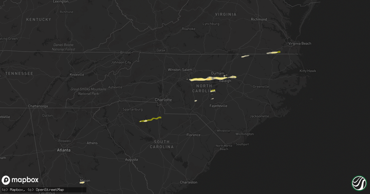
Hail Map in North Carolina on April 22, 2025
Get this storm
April 22 map
$229
one time, instant access
Download today. No call, no setup
Keep the $229
Bought the map and want the full workflow? Apply the entire $229 to a subscription within 7 days. None of it is wasted.
Every map, not just this one
This buys you this map. Subscription and you get every map we run, in the markets you choose from a few cities to whole states to nationwide. Plus real-time alerts the moment a storm fires.
Contact data
Name, contact info, occupancy, even credit band for addresses in the footprint. You go from where it hit to who to call.
Become the source they trust
Unlimited branding weather history reports on demand. You already have the documented answer ready for the property owner, and you are the one who showed up with it.
Property data and RoofTrace estimates
Pull up any address you have got, its value and the exact code rules for that jurisdiction, straight from One Click Code. Then RoofTrace estimates the squares, pitch, and roof value, priced the way you price.
Storm reports in North Carolina
North Carolina
| Date | Description |
|---|---|
| 04/22/20254:28 PM CDT | Quarter inch hail reported from the public. |
| 04/22/20254:12 PM CDT | Report of 1.25 to 1.5 inch hail near the intersection of evans rd and aviation parkway. |
| 04/22/20254:12 PM CDT | Report of 1.25 to 1.5 inch hail near the intersection of evans rd and aviation parkway. |
| 04/22/20254:10 PM CDT | Quarter inch hail reported in the town of morrisville. |
| 04/22/20253:33 PM CDT | Corrects previous tstm wnd dmg report from 3 n bynum. A tree was snapped and fell on several powerlines near the intersection of oak hill rd and manns chapel rd. |
| 04/22/20253:30 PM CDT | A tree fell on powerlines near the intersection of birnamwood dr and white cross rd. |
| 04/22/20253:29 PM CDT | A tree fell on powerlines near the intersection of white cross rd and crawford dairy rd north of pittsboro. |
| 04/22/20253:23 PM CDT | 1.25 to 1.5 inch hail near the intersection of chicken bridge rd and nc highway 87 north. |
| 04/22/20253:10 PM CDT | Broadcast media reported quarter size hail in the town of silk hope in chatham county. |
| 04/22/20252:57 PM CDT | Report from mping: ping pong ball |
| 04/22/20252:51 PM CDT | Report from mping: quarter |
| 04/22/20252:46 PM CDT | 1.25 to 1.5 inch hail reported in the town of staley. |
| 04/22/20252:39 PM CDT | 1.25 inch hail... Size estimated from picture. |
| 04/22/20252:30 PM CDT | Estimated quarter sized hail report via slack in randleman... Nc. |
| 04/22/20252:21 PM CDT | Report from mping: quarter |
| 04/22/20251:37 PM CDT | Tree down on powerlines. |
All States Impacted by Hail Map on April 22, 2025
Cities Impacted by Hail Map on April 22, 2025
- Palmetto, LA
- Washington, LA
- Deville, LA
- Port Barre, LA
- Glenmora, LA
- Forest Hill, LA
- Randleman, NC
- Asheboro, NC
- Sophia, NC
- Franklinville, NC
- Newhebron, MS
- Climax, NC
- Liberty, NC
- Staley, NC
- Macon, NC
- Warrenton, NC
- Center Point, LA
- Effie, LA
- Kiln, MS
- Sanford, NC
- Siler City, NC
- Broadway, NC
- Snow Camp, NC
- Jackson Springs, NC
- Candor, NC
- Jonesville, LA
- Littleton, NC
- Prentiss, MS
- Ovett, MS
- Ellisville, MS
- Ville Platte, LA
- Macon, MS
- Brooksville, MS
- Ramseur, NC
- Mount Olive, MS
- Pittsboro, NC
- Trinity, NC
- Cheneyville, LA
- Marksville, LA
- Shuqualak, MS
- Childersburg, AL
- Lumberton, MS
- Gaston, NC
- Port Allen, LA
- Baton Rouge, LA
- Baker, LA
- Bunkie, LA
- Union, SC
- Whitmire, SC
- Carlisle, SC
- Dermott, AR
- Graham, NC
- Chapel Hill, NC
- Dry Prong, LA
- Colfax, LA
- Alpine, AL
- Sieper, LA
- Chester, SC
- Petal, MS
- Zachary, LA
- Boyce, LA
- Otis, LA
- Transylvania, LA
- Evergreen, LA
- Wilmar, AR
- Lake Village, AR
- Rayville, LA
- Cottonport, LA
- Morrow, LA
- Durham, NC
- Apex, NC
- Cary, NC
- Morrisville, NC
- Fort Stockton, TX
- Yates City, IL
- Aliceville, AL
- Monticello, AR
- Saint Landry, LA
- Plaucheville, LA
- Talladega, AL
- Pell City, AL
- Raleigh, NC
- Claude, TX
- Imperial, TX
- Delhi, LA
- Moselle, MS
- Fountain Hill, AR
- Farmington, IL
- Elmwood, IL
- Lincoln, AL
- Clarendon, TX
- Richburg, SC
- Fort Lawn, SC
- Newsoms, VA
- Boykins, VA
- Scooba, MS
- Emelle, AL
- Lizella, GA
- Natchez, LA
- Lena, LA
- Provencal, LA
- Eupora, MS
- Franklin, VA
- Utica, MS
- Wake Forest, NC
- Wendell, NC
- Zebulon, NC
- Littlefield, TX
- Sunset, LA
- Carencro, LA
- Macon, GA
- Cloutierville, LA
- Uniontown, AL
- Amherst, TX
- Boligee, AL
- Arnaudville, LA
- Suffolk, VA
- Hazlehurst, MS
- Eunice, LA
- Tulia, TX
- Kress, TX
- Anacoco, LA
- Olton, TX
- Plainview, TX
- Hale Center, TX
- Opelousas, LA
- Church Point, LA
- Lakeview, TX
- Cameron, NC
- Eutaw, AL
- Mantee, MS
- Fieldton, TX
- Miami, TX
- Canadian, TX
- Wesson, MS
- Sikes, LA
- Quitaque, TX
- Robeline, LA
- Chatham, LA
- Goldsmith, TX
- Jonesboro, LA
- Wink, TX
- Raymond, MS
- Durham, OK
- Hedley, TX
- Kermit, TX
- Turkey, TX
- Childress, TX
- Krotz Springs, LA
- Bolton, MS
- Eros, LA
- Big Lake, TX
- Foxworth, MS
- Burkeville, TX
- Lafayette, LA
- West Monroe, LA
- Plains, TX
- Breaux Bridge, LA
- Hemphill, TX
- Pitkin, LA
- Brookhaven, MS
- Carthage, MS
- Mora, LA
- Dryden, TX
- Mertzon, TX
- Spivey, KS
- Zenda, KS
- Nashville, KS
- Cunningham, KS
- Calhoun, LA
- Hineston, LA
- Freedom, OK
- Medicine Lodge, KS
- Monroe, LA
- Philadelphia, MS
- Leesville, LA
- Saint Martinville, LA
- Sheffield, TX
- Kingman, KS
- Barnhart, TX
- Alva, OK
- Downsville, LA
- Floydada, TX
- Pretty Prairie, KS
- Isabel, KS
- Lake City, KS
- Coldwater, KS
- Lorman, MS
- Fayette, MS
- Arlington, KS
- Lockney, TX
- Monticello, MS
- Denver City, TX
- Salina, KS
- Brookville, KS
- Haven, KS
- Hutchinson, KS
- Matador, TX
- Flomot, TX
- Austin, TX
- Round Rock, TX
- Pflugerville, TX
- Burlington, OK
- Kiowa, KS
- Salado, TX
- Holland, TX
- Jarrell, TX
- Bartlett, TX
- Manor, TX
- Hutto, TX
- Georgetown, TX
- Coupland, TX
- Taylor, TX
- Winters, TX
- Farmerville, LA
- Choudrant, LA
- Anton, TX
- New Cambria, KS
- Ozona, TX
- Burrton, KS
- Mount Hope, KS
- Halstead, KS
- Tescott, KS
- Saint Joseph, LA
- Wingate, TX
- Sedgwick, KS
- Solomon, KS
- Falun, KS
- Newton, KS
- Bennington, KS
- Granger, TX
- Milam, TX
- North Newton, KS
- Walton, KS
- Peabody, KS
- Wilmore, KS
- Oakdale, LA
- Eldorado, TX
- Sonora, TX
- Abilene, KS
- Ellerbe, NC
- Elizabeth, LA
- Minneapolis, KS
- Maryneal, TX
- Lindsborg, KS
- Hardtner, KS
- Hesston, KS
- Seagraves, TX
- Florence, KS
- Assaria, KS
- Hope, KS
- Mount Morris, IL
- Oregon, IL
- Paducah, TX
- Herington, KS
- Gypsum, KS
- Newellton, LA
- Sondheimer, LA
- Roaring Springs, TX
- Wilsey, KS
- San Angelo, TX
- Vancourt, TX
- Abilene, TX
- Carrizo Springs, TX
- Eagle Pass, TX
- Laredo, TX
- Clay Center, KS
- Longford, KS
- Crosbyton, TX
- Petersburg, TX
- Tuscola, TX
- San Augustine, TX
- Shelbyville, TX
- Mcadoo, TX
- Ralls, TX
- Strong City, KS
- Manchester, OK
- Alta Vista, KS
- Junction City, KS
- Council Grove, KS
- Afton, TX
- Dickens, TX
- Durham, KS
- Crowell, TX
- Nevada, IA
- Emporia, KS
- Tampa, KS
- Cedar Point, KS
- Ames, IA
- Kellerton, IA
- Grand River, IA
- Lamoni, IA
- Americus, KS
- Colo, IA
- Caldwell, KS
- Medford, OK
- Mount Ayr, IA
- State Center, IA
- Decatur, IA
- Bronson, TX
- Melbourne, IA
- Marshalltown, IA
- Rocksprings, TX
- Lena, MS
- Menard, TX
- Haverhill, IA
- Lake Providence, LA
- Seymour, TX
- Leon, IA
- Brady, TX
- Braman, OK
- Carrollton, MS
- Greenwood, MS
- Tchula, MS
- Sidon, MS
- Mullin, TX
- Beverly, KS
- Lincoln, KS
- Center, TX
- Fairfield, IA
- Lockridge, IA
- Geuda Springs, KS
- Newkirk, OK
- Hext, TX
- Marion, KS
- Elmdale, KS
- Ramona, KS
- Le Grand, IA
- Montour, IA
- Gilman, IA
- Holcomb, MS
- London, TX
- Junction, TX
- Aspermont, TX
- Tama, IA
- Benjamin, TX
- Munday, TX
- Knox City, TX
- Grenada, MS
- Old Glory, TX
- Mason, TX
- Vernon, TX
- Chillicothe, TX
- Spur, TX
- Rochester, TX
- Coleman, TX
- Barksdale, TX
- Albany, TX
- Haskell, TX
- Cisco, TX
- Throckmorton, TX
- Goree, TX
- Ranger, TX
- Eastland, TX
- Weinert, TX
- Woodson, TX
- Breckenridge, TX
- Brownwood, TX
- Camp Wood, TX
- Comanche, TX
- Cruger, MS
- Zephyr, TX
- Mountain Home, TX
- Belzoni, MS
- Ida Grove, IA
- Burkett, TX
- Doss, TX
- Harrold, TX
- Electra, TX
- Oklaunion, TX
- Uvalde, TX
- Wiergate, TX
- Arthur, IA
- Odebolt, IA
- Schlater, MS
- Davidson, OK
- Del Rio, TX
- Lake View, IA
- Lytton, IA
- Medina, TX
- Wall Lake, IA
- Harper, TX
- Fredericksburg, TX
- Bandera, TX
- Newcastle, TX
- Barnum, IA
- Eldridge, IA
- Long Grove, IA
- Bennett, IA
- Iowa Park, TX
- Tarpley, TX
- Danbury, IA
- Correctionville, IA
- Dublin, TX
- Concan, TX
- Caddo, TX
- Sloan, IA
- Hornick, IA
- Battle Creek, IA
- Holstein, IA
- Wichita Falls, TX
- Graham, TX
- Princeton, IA
- Gustine, TX
- Knippa, TX
- South Bend, TX
- Sabinal, TX
- Anthon, IA
- Oto, IA
- Moville, IA
- Lake City, IA
- Priddy, TX
- Windthorst, TX
- Llano, TX
- Auburn, IA
- Rockwell City, IA
- Sac City, IA
- Batesville, TX
- Loving, TX
- Henrietta, TX
- Jacksboro, TX
- Tow, TX
- Olney, TX
- Bryson, TX
- Graford, TX
- Jermyn, TX
- Stephenville, TX
- Perrin, TX
- Bellevue, TX
- Bowie, TX
- Hico, TX
- Bridgeport, TX
- Poolville, TX
- Chico, TX
- Sunset, TX
- Pearsall, TX
- Paradise, TX
- Dilley, TX
- Decatur, TX
- Newark, TX
- Fort Worth, TX
- Haslet, TX
- Rhome, TX
- Godley, TX
- Keller, TX
- Roanoke, TX
- Justin, TX
- Argyle, TX
- Azle, TX
- Sanger, TX
- Krum, TX
- Denton, TX
- Ponder, TX
- Grapevine, TX
- Coppell, TX
- Flower Mound, TX
- Southlake, TX
- Irving, TX
- Dallas, TX
- Lewisville, TX
- Prosper, TX
- Aubrey, TX
- Little Elm, TX
- Lake Dallas, TX
- Frisco, TX
- Mckinney, TX
- The Colony, TX
- Gainesville, TX
- Gilbert, IA
- Kempner, TX
- Lometa, TX
- May, TX
- Lampasas, TX
- Briggs, TX
- Early, TX
- Goldthwaite, TX
- Florence, TX
- Buckholts, TX
- Coyanosa, TX
- Lawn, TX
- Hattiesburg, MS
- Hermanville, MS
- Georgetown, MS
- Utopia, TX
- Portland, TX
- Aransas Pass, TX


