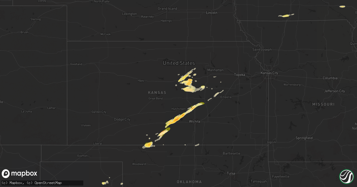
Hail Map in Kansas on April 22, 2025
Get this storm
April 22 map
$229
one time, instant access
Download today. No call, no setup
Keep the $229
Bought the map and want the full workflow? Apply the entire $229 to a subscription within 7 days. None of it is wasted.
Every map, not just this one
This buys you this map. Subscription and you get every map we run, in the markets you choose from a few cities to whole states to nationwide. Plus real-time alerts the moment a storm fires.
Contact data
Name, contact info, occupancy, even credit band for addresses in the footprint. You go from where it hit to who to call.
Become the source they trust
Unlimited branding weather history reports on demand. You already have the documented answer ready for the property owner, and you are the one who showed up with it.
Property data and RoofTrace estimates
Pull up any address you have got, its value and the exact code rules for that jurisdiction, straight from One Click Code. Then RoofTrace estimates the squares, pitch, and roof value, priced the way you price.
Storm reports in Kansas
Kansas
| Date | Description |
|---|---|
| 04/22/20253:22 AM CDT | Several reports of trees and wires down in kansas city... Kansas... From decaying showers moving through. |
| 04/22/20251:45 AM CDT | Decaying convective showers produced strong wind gusts of 50 to 60 mph... Including this private weather sensor... In western into central portions of the kc metro area |
| 04/22/20251:08 AM CDT | Decaying convective showers produced strong winds in leavenworth county. Several gauges reported gusts of 50 to 65 mph... Including this private weather sensor. |
| 04/21/202510:50 PM CDT | A local report indicates 1.50 inch wind near 2 SE Salina |
| 04/21/202510:45 PM CDT | A local report indicates 1.25 inch wind near 2 SE Salina |
| 04/21/202510:42 PM CDT | . |
| 04/21/202510:38 PM CDT | A local report indicates 1.00 inch wind near 2 S Salina |
| 04/21/20259:50 PM CDT | Hail covering i-135... Making it very slippery. |
| 04/21/20259:23 PM CDT | Received through mping). |
| 04/21/20259:21 PM CDT | A local report indicates 1.00 inch wind near Hope |
| 04/21/20259:05 PM CDT | A local report indicates 1.25 inch wind near Hesston |
| 04/21/20259:01 PM CDT | Report from mping: ping pong ball |
| 04/21/20258:52 PM CDT | A local report indicates 1.75 inch wind near 3 NW North Newton |
| 04/21/20258:47 PM CDT | Received through mping. |
| 04/21/20258:38 PM CDT | Courtesy of kake. |
| 04/21/20258:38 PM CDT | Courtesy of kwch. |
| 04/21/20258:38 PM CDT | Received via social media. |
| 04/21/20258:30 PM CDT | Courtesy of kwch. |
| 04/21/20258:20 PM CDT | A local report indicates 1.25 inch wind near Brookville |
| 04/21/20258:19 PM CDT | A local report indicates 1.25 inch wind near 1 N Glendale |
| 04/21/20258:15 PM CDT | A local report indicates 1.75 inch wind near 1 S Haven |
| 04/21/20258:09 PM CDT | A local report indicates 1.00 inch wind near 2 S Glendale |
| 04/21/20258:03 PM CDT | A local report indicates 1.50 inch wind near 6 N Mt Vernon |
| 04/21/20257:52 PM CDT | Courtesy of kwch. |
| 04/21/20257:52 PM CDT | Courtesy of kwch. |
| 04/21/20257:52 PM CDT | Courtesy of kwch. |
| 04/21/20257:52 PM CDT | Courtesy of kwch. |
| 04/21/20257:51 PM CDT | Courtesy of kake tv. |
| 04/21/20257:45 PM CDT | Barber county emergency manager sent a picture of gold ball size hail via slack. |
| 04/21/20257:39 PM CDT | Comanche county emergency manager sent a picture of golf ball size hail via slack. |
| 04/21/20257:37 PM CDT | Picture of ping pong ball size hail sent via x. Time estimated from radar. |
| 04/21/20257:37 PM CDT | Picture of ping pong ball size hail sent via x. Time estimated from radar. |
| 04/21/20257:35 PM CDT | Picture of golf ball size hail sent via x. |
| 04/21/20257:35 PM CDT | A local report indicates 1.00 inch wind near 3 N Medicine Lodge |
| 04/21/20257:31 PM CDT | Report of dime to quarter size hail... Relayed via social media. |
| 04/21/20257:28 PM CDT | A local report indicates 1.50 inch wind near 6 SE Penalosa |
| 04/21/20257:20 PM CDT | A local report indicates 1.50 inch wind near 3 W Medicine Lodge |
All States Impacted by Hail Map on April 22, 2025
Cities Impacted by Hail Map on April 22, 2025
- Palmetto, LA
- Washington, LA
- Deville, LA
- Port Barre, LA
- Glenmora, LA
- Forest Hill, LA
- Randleman, NC
- Asheboro, NC
- Sophia, NC
- Franklinville, NC
- Newhebron, MS
- Climax, NC
- Liberty, NC
- Staley, NC
- Macon, NC
- Warrenton, NC
- Center Point, LA
- Effie, LA
- Kiln, MS
- Sanford, NC
- Siler City, NC
- Broadway, NC
- Snow Camp, NC
- Jackson Springs, NC
- Candor, NC
- Jonesville, LA
- Littleton, NC
- Prentiss, MS
- Ovett, MS
- Ellisville, MS
- Ville Platte, LA
- Macon, MS
- Brooksville, MS
- Ramseur, NC
- Mount Olive, MS
- Pittsboro, NC
- Trinity, NC
- Cheneyville, LA
- Marksville, LA
- Shuqualak, MS
- Childersburg, AL
- Lumberton, MS
- Gaston, NC
- Port Allen, LA
- Baton Rouge, LA
- Baker, LA
- Bunkie, LA
- Union, SC
- Whitmire, SC
- Carlisle, SC
- Dermott, AR
- Graham, NC
- Chapel Hill, NC
- Dry Prong, LA
- Colfax, LA
- Alpine, AL
- Sieper, LA
- Chester, SC
- Petal, MS
- Zachary, LA
- Boyce, LA
- Otis, LA
- Transylvania, LA
- Evergreen, LA
- Wilmar, AR
- Lake Village, AR
- Rayville, LA
- Cottonport, LA
- Morrow, LA
- Durham, NC
- Apex, NC
- Cary, NC
- Morrisville, NC
- Fort Stockton, TX
- Yates City, IL
- Aliceville, AL
- Monticello, AR
- Saint Landry, LA
- Plaucheville, LA
- Talladega, AL
- Pell City, AL
- Raleigh, NC
- Claude, TX
- Imperial, TX
- Delhi, LA
- Moselle, MS
- Fountain Hill, AR
- Farmington, IL
- Elmwood, IL
- Lincoln, AL
- Clarendon, TX
- Richburg, SC
- Fort Lawn, SC
- Newsoms, VA
- Boykins, VA
- Scooba, MS
- Emelle, AL
- Lizella, GA
- Natchez, LA
- Lena, LA
- Provencal, LA
- Eupora, MS
- Franklin, VA
- Utica, MS
- Wake Forest, NC
- Wendell, NC
- Zebulon, NC
- Littlefield, TX
- Sunset, LA
- Carencro, LA
- Macon, GA
- Cloutierville, LA
- Uniontown, AL
- Amherst, TX
- Boligee, AL
- Arnaudville, LA
- Suffolk, VA
- Hazlehurst, MS
- Eunice, LA
- Tulia, TX
- Kress, TX
- Anacoco, LA
- Olton, TX
- Plainview, TX
- Hale Center, TX
- Opelousas, LA
- Church Point, LA
- Lakeview, TX
- Cameron, NC
- Eutaw, AL
- Mantee, MS
- Fieldton, TX
- Miami, TX
- Canadian, TX
- Wesson, MS
- Sikes, LA
- Quitaque, TX
- Robeline, LA
- Chatham, LA
- Goldsmith, TX
- Jonesboro, LA
- Wink, TX
- Raymond, MS
- Durham, OK
- Hedley, TX
- Kermit, TX
- Turkey, TX
- Childress, TX
- Krotz Springs, LA
- Bolton, MS
- Eros, LA
- Big Lake, TX
- Foxworth, MS
- Burkeville, TX
- Lafayette, LA
- West Monroe, LA
- Plains, TX
- Breaux Bridge, LA
- Hemphill, TX
- Pitkin, LA
- Brookhaven, MS
- Carthage, MS
- Mora, LA
- Dryden, TX
- Mertzon, TX
- Spivey, KS
- Zenda, KS
- Nashville, KS
- Cunningham, KS
- Calhoun, LA
- Hineston, LA
- Freedom, OK
- Medicine Lodge, KS
- Monroe, LA
- Philadelphia, MS
- Leesville, LA
- Saint Martinville, LA
- Sheffield, TX
- Kingman, KS
- Barnhart, TX
- Alva, OK
- Downsville, LA
- Floydada, TX
- Pretty Prairie, KS
- Isabel, KS
- Lake City, KS
- Coldwater, KS
- Lorman, MS
- Fayette, MS
- Arlington, KS
- Lockney, TX
- Monticello, MS
- Denver City, TX
- Salina, KS
- Brookville, KS
- Haven, KS
- Hutchinson, KS
- Matador, TX
- Flomot, TX
- Austin, TX
- Round Rock, TX
- Pflugerville, TX
- Burlington, OK
- Kiowa, KS
- Salado, TX
- Holland, TX
- Jarrell, TX
- Bartlett, TX
- Manor, TX
- Hutto, TX
- Georgetown, TX
- Coupland, TX
- Taylor, TX
- Winters, TX
- Farmerville, LA
- Choudrant, LA
- Anton, TX
- New Cambria, KS
- Ozona, TX
- Burrton, KS
- Mount Hope, KS
- Halstead, KS
- Tescott, KS
- Saint Joseph, LA
- Wingate, TX
- Sedgwick, KS
- Solomon, KS
- Falun, KS
- Newton, KS
- Bennington, KS
- Granger, TX
- Milam, TX
- North Newton, KS
- Walton, KS
- Peabody, KS
- Wilmore, KS
- Oakdale, LA
- Eldorado, TX
- Sonora, TX
- Abilene, KS
- Ellerbe, NC
- Elizabeth, LA
- Minneapolis, KS
- Maryneal, TX
- Lindsborg, KS
- Hardtner, KS
- Hesston, KS
- Seagraves, TX
- Florence, KS
- Assaria, KS
- Hope, KS
- Mount Morris, IL
- Oregon, IL
- Paducah, TX
- Herington, KS
- Gypsum, KS
- Newellton, LA
- Sondheimer, LA
- Roaring Springs, TX
- Wilsey, KS
- San Angelo, TX
- Vancourt, TX
- Abilene, TX
- Carrizo Springs, TX
- Eagle Pass, TX
- Laredo, TX
- Clay Center, KS
- Longford, KS
- Crosbyton, TX
- Petersburg, TX
- Tuscola, TX
- San Augustine, TX
- Shelbyville, TX
- Mcadoo, TX
- Ralls, TX
- Strong City, KS
- Manchester, OK
- Alta Vista, KS
- Junction City, KS
- Council Grove, KS
- Afton, TX
- Dickens, TX
- Durham, KS
- Crowell, TX
- Nevada, IA
- Emporia, KS
- Tampa, KS
- Cedar Point, KS
- Ames, IA
- Kellerton, IA
- Grand River, IA
- Lamoni, IA
- Americus, KS
- Colo, IA
- Caldwell, KS
- Medford, OK
- Mount Ayr, IA
- State Center, IA
- Decatur, IA
- Bronson, TX
- Melbourne, IA
- Marshalltown, IA
- Rocksprings, TX
- Lena, MS
- Menard, TX
- Haverhill, IA
- Lake Providence, LA
- Seymour, TX
- Leon, IA
- Brady, TX
- Braman, OK
- Carrollton, MS
- Greenwood, MS
- Tchula, MS
- Sidon, MS
- Mullin, TX
- Beverly, KS
- Lincoln, KS
- Center, TX
- Fairfield, IA
- Lockridge, IA
- Geuda Springs, KS
- Newkirk, OK
- Hext, TX
- Marion, KS
- Elmdale, KS
- Ramona, KS
- Le Grand, IA
- Montour, IA
- Gilman, IA
- Holcomb, MS
- London, TX
- Junction, TX
- Aspermont, TX
- Tama, IA
- Benjamin, TX
- Munday, TX
- Knox City, TX
- Grenada, MS
- Old Glory, TX
- Mason, TX
- Vernon, TX
- Chillicothe, TX
- Spur, TX
- Rochester, TX
- Coleman, TX
- Barksdale, TX
- Albany, TX
- Haskell, TX
- Cisco, TX
- Throckmorton, TX
- Goree, TX
- Ranger, TX
- Eastland, TX
- Weinert, TX
- Woodson, TX
- Breckenridge, TX
- Brownwood, TX
- Camp Wood, TX
- Comanche, TX
- Cruger, MS
- Zephyr, TX
- Mountain Home, TX
- Belzoni, MS
- Ida Grove, IA
- Burkett, TX
- Doss, TX
- Harrold, TX
- Electra, TX
- Oklaunion, TX
- Uvalde, TX
- Wiergate, TX
- Arthur, IA
- Odebolt, IA
- Schlater, MS
- Davidson, OK
- Del Rio, TX
- Lake View, IA
- Lytton, IA
- Medina, TX
- Wall Lake, IA
- Harper, TX
- Fredericksburg, TX
- Bandera, TX
- Newcastle, TX
- Barnum, IA
- Eldridge, IA
- Long Grove, IA
- Bennett, IA
- Iowa Park, TX
- Tarpley, TX
- Danbury, IA
- Correctionville, IA
- Dublin, TX
- Concan, TX
- Caddo, TX
- Sloan, IA
- Hornick, IA
- Battle Creek, IA
- Holstein, IA
- Wichita Falls, TX
- Graham, TX
- Princeton, IA
- Gustine, TX
- Knippa, TX
- South Bend, TX
- Sabinal, TX
- Anthon, IA
- Oto, IA
- Moville, IA
- Lake City, IA
- Priddy, TX
- Windthorst, TX
- Llano, TX
- Auburn, IA
- Rockwell City, IA
- Sac City, IA
- Batesville, TX
- Loving, TX
- Henrietta, TX
- Jacksboro, TX
- Tow, TX
- Olney, TX
- Bryson, TX
- Graford, TX
- Jermyn, TX
- Stephenville, TX
- Perrin, TX
- Bellevue, TX
- Bowie, TX
- Hico, TX
- Bridgeport, TX
- Poolville, TX
- Chico, TX
- Sunset, TX
- Pearsall, TX
- Paradise, TX
- Dilley, TX
- Decatur, TX
- Newark, TX
- Fort Worth, TX
- Haslet, TX
- Rhome, TX
- Godley, TX
- Keller, TX
- Roanoke, TX
- Justin, TX
- Argyle, TX
- Azle, TX
- Sanger, TX
- Krum, TX
- Denton, TX
- Ponder, TX
- Grapevine, TX
- Coppell, TX
- Flower Mound, TX
- Southlake, TX
- Irving, TX
- Dallas, TX
- Lewisville, TX
- Prosper, TX
- Aubrey, TX
- Little Elm, TX
- Lake Dallas, TX
- Frisco, TX
- Mckinney, TX
- The Colony, TX
- Gainesville, TX
- Gilbert, IA
- Kempner, TX
- Lometa, TX
- May, TX
- Lampasas, TX
- Briggs, TX
- Early, TX
- Goldthwaite, TX
- Florence, TX
- Buckholts, TX
- Coyanosa, TX
- Lawn, TX
- Hattiesburg, MS
- Hermanville, MS
- Georgetown, MS
- Utopia, TX
- Portland, TX
- Aransas Pass, TX


