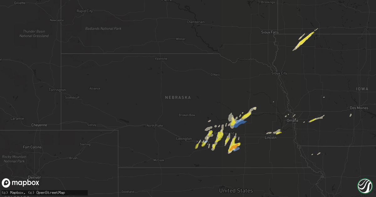
Hail Map in Nebraska on April 21, 2022
Get this storm
April 21 map
$229
one time, instant access
Download today. No call, no setup
Keep the $229
Bought the map and want the full workflow? Apply the entire $229 to a subscription within 7 days. None of it is wasted.
Every map, not just this one
This buys you this map. Subscription and you get every map we run, in the markets you choose from a few cities to whole states to nationwide. Plus real-time alerts the moment a storm fires.
Contact data
Name, contact info, occupancy, even credit band for addresses in the footprint. You go from where it hit to who to call.
Become the source they trust
Unlimited branding weather history reports on demand. You already have the documented answer ready for the property owner, and you are the one who showed up with it.
Property data and RoofTrace estimates
Pull up any address you have got, its value and the exact code rules for that jurisdiction, straight from One Click Code. Then RoofTrace estimates the squares, pitch, and roof value, priced the way you price.
Storm reports in Nebraska
Nebraska
| Date | Description |
|---|---|
| 04/21/20226:32 AM CDT | At 1131 PM CDT, severe thunderstorms were located along a line extending from near Shelton to near Hansen to near Sutton, moving northeast at 25 mph. HAZARD...Quarter size hail. SOURCE...Radar indicated. IMPACT...Damage to vehicles is expected. Severe thunderstorms will be near... Doniphan and Saronville around 1135 PM CDT. Sutton around 1140 PM CDT. Stockham around 1150 PM CDT.Other locations in the path of these severe thunderstorms includeAlda, Grand Island, Phillips, Henderson, Cairo and Chapman.This includes Interstate 80 between mile markers 293 and 346. |
| 04/21/20225:54 AM CDT | At 1053 PM CDT, a severe thunderstorm was located over Fairfield, or 17 miles southeast of Hastings, moving northeast at 25 mph. HAZARD...Quarter size hail. SOURCE...Radar indicated. IMPACT...Damage to vehicles is expected. This severe thunderstorm will be near... Clay Center around 1105 PM CDT.Other locations in the path of this severe thunderstorm includeHarvard, Saronville and Sutton. |
| 04/21/20224:50 AM CDT | From social media. Penny to quarter size hail. |
| 04/21/20222:24 AM CDT | Mesonet station ur441. |
| 04/21/202212:01 AM CDT | A local report indicates 1.00 inch wind near 2 WNW GRAND ISLAND |
| 04/20/202211:43 PM CDT | Report from facebook. Time estimated from radar. |
| 04/20/202211:31 PM CDT | Estimated 55-65 mph on back side of thunderstorm. Two old cedar trees damaged. One 12 inches in diameter. |
| 04/20/202211:31 PM CDT | Est 55 to 65mph winds which snapped 3 12 inch cedar trees on property plus several smaller branches. |
| 04/20/202211:22 PM CDT | Davis weatherlink station. |
| 04/20/202211:17 PM CDT | Davis weatherlink station. |
All States Impacted by Hail Map on April 21, 2022
Cities Impacted by Hail Map on April 21, 2022
- Dedham, IA
- Coon Rapids, IA
- Audubon, IA
- Eureka, SD
- West Point, NE
- Lakefield, MN
- Jackson, MN
- Leigh, NE
- Columbus, NE
- Ravenna, NE
- Gibbon, NE
- Alexander, KS
- Skidmore, MO
- Maryville, MO
- Griswold, IA
- Lewis, IA
- Kearney, NE
- Fort Scott, KS
- Larned, KS
- Albert, KS
- Pawnee Rock, KS
- Otis, KS
- Silver Creek, NE
- Genoa, NE
- Minden, NE
- Flemington, MO
- Uniontown, KS
- Mapleton, KS
- Bronson, KS
- Blue Mound, KS
- Spur, TX
- Dickens, TX
- Pleasanton, NE
- Hazard, NE
- Rockville, NE
- Clarks, NE
- Wood River, NE
- Bennington, NE
- Dannebrog, NE
- Crescent, IA
- Honey Creek, IA
- Kenesaw, NE
- Heartwell, NE
- Giltner, NE
- Doniphan, NE
- Trumbull, NE
- Hastings, NE
- Phillips, NE
- Aurora, NE
- Omaha, NE
- Fort Calhoun, NE
- Lincoln, NE
- Davey, NE
- Malcolm, NE
- Raymond, NE
- Ashton, IA
- Lake Park, IA
- Sheldon, IA
- Hartley, IA
- Ocheyedan, IA
- Melvin, IA
- Sanborn, IA
- Harris, IA
- Glenvil, NE
- Harvard, NE
- Sutton, NE
- Clay Center, NE
- Fairfield, NE
- Saronville, NE
- Offerle, KS
- Moran, KS
- Bolivar, MO
- Winterset, IA
- Van Meter, IA
- Prole, IA
- Sheldon, MO
- Jerico Springs, MO
- El Dorado Springs, MO
- Treynor, IA
- Carson, IA
- Deerfield, MO
- Moundville, MO
- Richards, MO
- Nevada, MO
- Milo, MO
- Fair Play, MO
- Morrisville, MO
- Aldrich, MO
- Dadeville, MO
- Half Way, MO
- Stockton, MO
- Brighton, MO
- Walnut Grove, MO
- Bucklin, KS
- Lockwood, MO
- Everton, MO
- Jasper, MO
- Liberal, MO
- Oronogo, MO
- Golden City, MO
- Lamar, MO
- South Greenfield, MO
- Duncan, NE
- Central City, NE
- Marquette, NE
- Fullerton, NE
- Chapman, NE
- Monroe, NE
- Platte Center, NE
- Clarkson, NE
- Palmer, NE
- Osceola, NE
- Archer, NE
- Belgrade, NE
- Alvo, NE
- Waverly, NE
- Greenwood, NE
- Saint Libory, NE
- Atlantic, IA
- Spearville, KS
- Bronaugh, MO
- Pleasant Hope, MO
- Arcola, MO
- Dunnegan, MO
- Buffalo, MO
- Redfield, KS
- Fair Grove, MO
- Elkland, MO
- Conway, MO
- Niangua, MO
- Holdrege, NE
- Funk, NE
- Sibley, IA
- Henderson, NE
- Boelus, NE
- Fairfax, MO
- Rush Center, KS
- Nekoma, KS
- Ashton, NE
- Grand Island, NE
- Alda, NE
- Deweese, NE
- Hampton, NE
- Grafton, NE
- Cumberland, IA
- Wiota, IA
- Axtell, NE
- Shelton, NE
- Kinsley, KS
- Ashland, NE
- Kincaid, KS
- La Harpe, KS
- Cairo, NE
- Holstein, NE
- Saint Paul, NE
- Juniata, NE
- Worthington, MN
- Round Lake, MN
- Council Bluffs, IA
- Loup City, NE
- Archer, IA
- Hospers, IA
- Humansville, MO
- Hume, MO
- Fulton, KS
- Justiceburg, TX
- Marshfield, MO
- Ford, KS
- Garfield, KS
- La Crosse, KS
- Ness City, KS
- Great Bend, KS
- Long Lane, MO
- Oakland, IA
- Elm Creek, NE
- Murdock, NE
- Edgar, NE
- Geneva, NE
- Hordville, NE
- Polk, NE
- Shelby, NE
- Crosbyton, TX
- Snyder, TX


