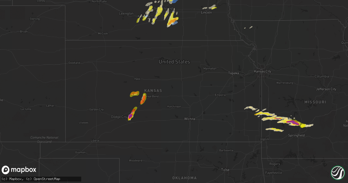
Hail Map in Kansas on April 21, 2022
Get this storm
April 21 map
$229
one time, instant access
Download today. No call, no setup
Keep the $229
Bought the map and want the full workflow? Apply the entire $229 to a subscription within 7 days. None of it is wasted.
Every map, not just this one
This buys you this map. Subscription and you get every map we run, in the markets you choose from a few cities to whole states to nationwide. Plus real-time alerts the moment a storm fires.
Contact data
Name, contact info, occupancy, even credit band for addresses in the footprint. You go from where it hit to who to call.
Become the source they trust
Unlimited branding weather history reports on demand. You already have the documented answer ready for the property owner, and you are the one who showed up with it.
Property data and RoofTrace estimates
Pull up any address you have got, its value and the exact code rules for that jurisdiction, straight from One Click Code. Then RoofTrace estimates the squares, pitch, and roof value, priced the way you price.
Storm reports in Kansas
Kansas
| Date | Description |
|---|---|
| 04/21/20222:49 PM CDT | Estimated quarter size hail in fort scott. Time estimated from radar. |
| 04/21/20222:40 PM CDT | Report from mping of half dollar size hail. Time estimated from radar. |
| 04/21/20222:40 PM CDT | Report from mping of ping pong ball size hail. Time estimated from radar. |
| 04/21/20222:22 PM CDT | Report from mping of half dollar size hail. Time estimated from radar. |
| 04/21/20223:39 AM CDT | At 839 PM CDT, a severe thunderstorm was located near Kinsley, moving northeast at 25 mph. HAZARD...Quarter size hail. SOURCE...Radar indicated. IMPACT...Damage to vehicles is expected. This severe thunderstorm will be near... Kinsley around 850 PM CDT.Other locations in the path of this severe thunderstorm includeLewis. |
| 04/21/20223:13 AM CDT | At 813 PM CDT, a severe thunderstorm was located near Larned, moving northeast at 25 mph. HAZARD...60 mph wind gusts and half dollar size hail. SOURCE...Radar indicated. IMPACT...Hail damage to vehicles is expected. Expect wind damage to roofs, siding, and trees. Locations impacted include... Great Bend, Pawnee Rock, Albert, Olmitz, Great Bend Airport and Cheyenne Bottoms. |
| 04/21/20223:07 AM CDT | At 806 PM CDT, a severe thunderstorm was located very near Larned, moving northeast at 20 mph. HAZARD...Two inch hail. SOURCE...Radar indicated. IMPACT...People and animals outdoors will be injured. Expect damage to roofs, siding, windows, and vehicles. This severe thunderstorm will be near... Larned around 815 PM CDT.Other locations in the path of this severe thunderstorm includeRadium. |
| 04/21/20222:57 AM CDT | At 756 PM CDT, a severe thunderstorm was located near Nekoma, moving east at 30 mph. THIS IS A DESTRUCTIVE STORM FOR Nekoma. HAZARD...Baseball size hail. SOURCE...Radar indicated. IMPACT...People and animals outdoors will be severely injured. Expect shattered windows, extensive damage to roofs, siding, and vehicles. This severe thunderstorm will be near... La Crosse and Rush Center around 810 PM CDT.Other locations in the path of this severe thunderstorm includeBison, Timken, Otis and Shaffer. |
| 04/21/20222:55 AM CDT | At 754 PM CDT, a severe thunderstorm was located 7 miles south of Windhorst, moving northeast at 30 mph. Another severe storm was located 3 miles southwest of Kinsley moving northeast at 30 mph. HAZARD...Two inch hail. SOURCE...Trained weather spotters reported 2 inch hail 8 miles north of Bucklin. IMPACT...People and animals outdoors will be injured. Expect damage to roofs, siding, windows, and vehicles. This severe thunderstorm will be near... Windhorst around 800 PM CDT.Other locations in the path of this severe thunderstorm includeKinsley, Lewis and Garfield. |
| 04/21/20222:20 AM CDT | At 720 PM CDT, a severe thunderstorm was located near Bazine, moving northeast at 30 mph. HAZARD...Quarter size hail. SOURCE...Radar indicated. IMPACT...Damage to vehicles is expected. This severe thunderstorm will be near... Alexander around 735 PM CDT.Other locations in the path of this severe thunderstorm includeNekoma, McCracken, Hargrave and La Crosse. |
| 04/21/20222:15 AM CDT | At 715 PM CDT, a severe thunderstorm was located 8 miles north of Bucklin, moving northeast at 25 mph. HAZARD...Ping pong ball size hail. SOURCE...Radar indicated. IMPACT...People and animals outdoors will be injured. Expect damage to roofs, siding, windows, and vehicles. This severe thunderstorm will be near... Windhorst around 730 PM CDT.Other locations in the path of this severe thunderstorm includeKinsley. |
| 04/20/202210:12 PM CDT | At 312 PM CDT, a severe thunderstorm was located 9 miles east of Fort Scott, moving east at 20 mph. HAZARD...60 mph wind gusts and half dollar size hail. SOURCE...Radar indicated. IMPACT...Hail damage to vehicles is expected. Expect wind damage to roofs, siding, and trees. Locations impacted include... Nevada... Walker... Moundville... Richards... Milo... Deerfield... This includes Interstate 49 between mile markers 80 and 97. |
| 04/20/20229:39 PM CDT | At 239 PM CDT, a severe thunderstorm was located near Fort Scott, moving northeast at 30 mph. HAZARD...60 mph wind gusts and half dollar size hail. SOURCE...Radar indicated. IMPACT...Hail damage to vehicles is expected. Expect wind damage to roofs, siding, and trees. Locations impacted include... Fort Scott... Richards... Metz... Stotesbury... Hammond... Horton... This includes Interstate 49 between mile markers 99 and 107. |
| 04/20/20229:12 PM CDT | At 212 PM CDT, a severe thunderstorm was located 7 miles southeast of Blue Mound, or 9 miles southwest of Mound City, moving northeast at 30 mph. HAZARD...60 mph wind gusts and half dollar size hail. SOURCE...Radar indicated. IMPACT...Hail damage to vehicles is expected. Expect wind damage to roofs, siding, and trees. Locations impacted include... Fulton... Mapleton... Devon... Harding... Hammond... Xenia... |
| 04/20/20229:08 PM CDT | At 208 PM CDT, a severe thunderstorm was located 7 miles northwest of Sheldon, or 10 miles southwest of Nevada, moving northeast at 30 mph. HAZARD...60 mph wind gusts and half dollar size hail. SOURCE...Radar indicated. IMPACT...Hail damage to vehicles is expected. Expect wind damage to roofs, siding, and trees. Locations impacted include... Nevada... Sheldon... Montevallo... Walker... Bronaugh... Moundville... Richards... Milo... Deerfield... Metz... Stotesbury... Horton... Verdella... This includes Interstate 49 between mile markers 76 and 107. |
| 04/20/20229:03 PM CDT | At 203 PM CDT, a severe thunderstorm was located over Blue Mound, or 11 miles southwest of Mound City, moving east at 20 mph. HAZARD...60 mph wind gusts and half dollar size hail. SOURCE...Radar indicated. IMPACT...Hail damage to vehicles is expected. Expect wind damage to roofs, siding, and trees. Locations impacted include... Mound City and Blue Mound. |
| 04/20/20228:55 PM CDT | A local report indicates 1.00 inch wind near 1 ENE KINSLEY |
| 04/20/20228:40 PM CDT | At 140 PM CDT, a severe thunderstorm was located near Kincaid, moving northeast at 25 mph. HAZARD...60 mph wind gusts and quarter size hail. SOURCE...Radar indicated. IMPACT...Hail damage to vehicles is expected. Expect wind damage to roofs, siding, and trees. Locations impacted include... Kincaid. |
| 04/20/20228:36 PM CDT | A local report indicates 1.00 inch wind near 8 WSW CENTERVIEW |
| 04/20/20228:27 PM CDT | Barton county law enforcement relayed a 3rd party report of golf ball sized hail near pawnee rock. |
| 04/20/20228:12 PM CDT | A local report indicates 1.50 inch wind near 4 SSE ASH VALLEY |
| 04/20/20227:54 PM CDT | A local report indicates 2.00 inch wind near 7 ENE FORD |
| 04/20/20227:35 PM CDT | A local report indicates 1.50 inch wind near 1 SE WINDHORST |
| 04/20/20227:34 PM CDT | A local report indicates 1.75 inch wind near 1 S WINDHORST |
All States Impacted by Hail Map on April 21, 2022
Cities Impacted by Hail Map on April 21, 2022
- Dedham, IA
- Coon Rapids, IA
- Audubon, IA
- Eureka, SD
- West Point, NE
- Lakefield, MN
- Jackson, MN
- Leigh, NE
- Columbus, NE
- Ravenna, NE
- Gibbon, NE
- Alexander, KS
- Skidmore, MO
- Maryville, MO
- Griswold, IA
- Lewis, IA
- Kearney, NE
- Fort Scott, KS
- Larned, KS
- Albert, KS
- Pawnee Rock, KS
- Otis, KS
- Silver Creek, NE
- Genoa, NE
- Minden, NE
- Flemington, MO
- Uniontown, KS
- Mapleton, KS
- Bronson, KS
- Blue Mound, KS
- Spur, TX
- Dickens, TX
- Pleasanton, NE
- Hazard, NE
- Rockville, NE
- Clarks, NE
- Wood River, NE
- Bennington, NE
- Dannebrog, NE
- Crescent, IA
- Honey Creek, IA
- Kenesaw, NE
- Heartwell, NE
- Giltner, NE
- Doniphan, NE
- Trumbull, NE
- Hastings, NE
- Phillips, NE
- Aurora, NE
- Omaha, NE
- Fort Calhoun, NE
- Lincoln, NE
- Davey, NE
- Malcolm, NE
- Raymond, NE
- Ashton, IA
- Lake Park, IA
- Sheldon, IA
- Hartley, IA
- Ocheyedan, IA
- Melvin, IA
- Sanborn, IA
- Harris, IA
- Glenvil, NE
- Harvard, NE
- Sutton, NE
- Clay Center, NE
- Fairfield, NE
- Saronville, NE
- Offerle, KS
- Moran, KS
- Bolivar, MO
- Winterset, IA
- Van Meter, IA
- Prole, IA
- Sheldon, MO
- Jerico Springs, MO
- El Dorado Springs, MO
- Treynor, IA
- Carson, IA
- Deerfield, MO
- Moundville, MO
- Richards, MO
- Nevada, MO
- Milo, MO
- Fair Play, MO
- Morrisville, MO
- Aldrich, MO
- Dadeville, MO
- Half Way, MO
- Stockton, MO
- Brighton, MO
- Walnut Grove, MO
- Bucklin, KS
- Lockwood, MO
- Everton, MO
- Jasper, MO
- Liberal, MO
- Oronogo, MO
- Golden City, MO
- Lamar, MO
- South Greenfield, MO
- Duncan, NE
- Central City, NE
- Marquette, NE
- Fullerton, NE
- Chapman, NE
- Monroe, NE
- Platte Center, NE
- Clarkson, NE
- Palmer, NE
- Osceola, NE
- Archer, NE
- Belgrade, NE
- Alvo, NE
- Waverly, NE
- Greenwood, NE
- Saint Libory, NE
- Atlantic, IA
- Spearville, KS
- Bronaugh, MO
- Pleasant Hope, MO
- Arcola, MO
- Dunnegan, MO
- Buffalo, MO
- Redfield, KS
- Fair Grove, MO
- Elkland, MO
- Conway, MO
- Niangua, MO
- Holdrege, NE
- Funk, NE
- Sibley, IA
- Henderson, NE
- Boelus, NE
- Fairfax, MO
- Rush Center, KS
- Nekoma, KS
- Ashton, NE
- Grand Island, NE
- Alda, NE
- Deweese, NE
- Hampton, NE
- Grafton, NE
- Cumberland, IA
- Wiota, IA
- Axtell, NE
- Shelton, NE
- Kinsley, KS
- Ashland, NE
- Kincaid, KS
- La Harpe, KS
- Cairo, NE
- Holstein, NE
- Saint Paul, NE
- Juniata, NE
- Worthington, MN
- Round Lake, MN
- Council Bluffs, IA
- Loup City, NE
- Archer, IA
- Hospers, IA
- Humansville, MO
- Hume, MO
- Fulton, KS
- Justiceburg, TX
- Marshfield, MO
- Ford, KS
- Garfield, KS
- La Crosse, KS
- Ness City, KS
- Great Bend, KS
- Long Lane, MO
- Oakland, IA
- Elm Creek, NE
- Murdock, NE
- Edgar, NE
- Geneva, NE
- Hordville, NE
- Polk, NE
- Shelby, NE
- Crosbyton, TX
- Snyder, TX


