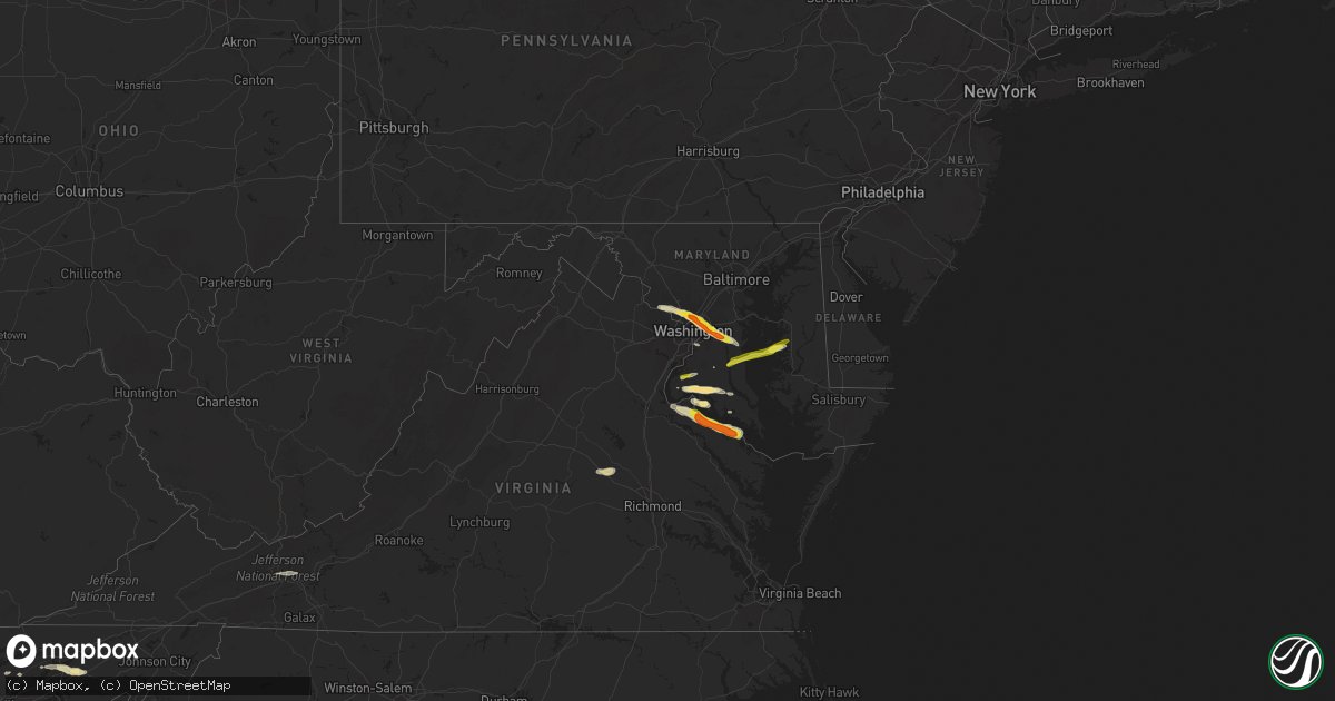
Hail Map in Maryland on April 21, 2017
Get this storm
April 21 map
$229
one time, instant access
Download today. No call, no setup
Keep the $229
Bought the map and want the full workflow? Apply the entire $229 to a subscription within 7 days. None of it is wasted.
Every map, not just this one
This buys you this map. Subscription and you get every map we run, in the markets you choose from a few cities to whole states to nationwide. Plus real-time alerts the moment a storm fires.
Contact data
Name, contact info, occupancy, even credit band for addresses in the footprint. You go from where it hit to who to call.
Become the source they trust
Unlimited branding weather history reports on demand. You already have the documented answer ready for the property owner, and you are the one who showed up with it.
Property data and RoofTrace estimates
Pull up any address you have got, its value and the exact code rules for that jurisdiction, straight from One Click Code. Then RoofTrace estimates the squares, pitch, and roof value, priced the way you price.
Storm reports in Maryland
Maryland
| Date | Description |
|---|---|
| 04/21/20176:49 PM CDT | Quarter size hail |
| 04/21/20176:36 PM CDT | Significant boat damage reported at the colonial beach yacht center. |
| 04/21/20176:23 PM CDT | Significant boat/building damage reported at the colonial beach yacht center. |
| 04/21/20174:44 PM CDT | Half dollar size hail |
| 04/21/20174:44 PM CDT | Tree down partially blocking the inner loop of capital beltway near md 355 |
| 04/21/20174:40 PM CDT | Trees and wires down onto car at 700 block sligo creek parkway. Road blocked. |
| 04/21/20174:39 PM CDT | Tree and wires down onto 4500 block woodfield rd. Road being closed. |
| 04/21/20174:37 PM CDT | Large trees down on powerlines near the intersection of route 4 and old crain highway. |
| 04/21/20174:35 PM CDT | Tree into a house at 1100 block of merwood dr |
| 04/21/20174:33 PM CDT | Trees and wires down partially blocking intersection of university blvd west and connecticut ave |
| 04/21/20174:23 PM CDT | Trees and wires down at 11200 block of gainsborough rd |
| 04/21/20174:20 PM CDT | Half dozen large trees uprooted at 800 block jackson ave. One person with minor injuries. |
| 04/21/20174:15 PM CDT | Quarter size hail |
| 04/21/20174:15 PM CDT | Tree into a house at 300 block of ethan allen ave |
| 04/21/20174:12 PM CDT | Quarter size hail |
| 04/21/20174:09 PM CDT | Tree into house at 8500 block of lynwood place....major damage to the house |
| 04/21/20174:07 PM CDT | Tree branches down into left shoulder of capital beltway outer loop at exit 36 md 187 old georgetown rd |
| 04/21/20174:05 PM CDT | Quarter size hail |
| 04/21/20174:04 PM CDT | Trees and wires down blocking the intersection of carroll ave and grant ave |
| 04/21/20174:03 PM CDT | Quarter size hail |
| 04/21/20174:03 PM CDT | Tree into a house with wires down at 8550 connecticut avenue. Road partially blocked. |
| 04/21/20174:02 PM CDT | Tree branches and power pole down blocking the street near intersection of montrose ave and weymouth st |
| 04/21/20173:58 PM CDT | A local report indicates 1.75 inch wind near 1 NW TAKOMA PARK |
| 04/21/20173:57 PM CDT | Large tree uprooted... Possibly onto a house |
| 04/21/20173:55 PM CDT | A local report indicates 1.00 inch wind near 1 NW TAKOMA PARK |
| 04/21/20173:55 PM CDT | Several large tree branches and wires down blocking the entire road near intersection of seven locks rd and bells mill rd |
| 04/21/20173:55 PM CDT | Sarbanes transit center |
| 04/21/20173:54 PM CDT | Tree into a house at 300 block of ethan allen ave |
| 04/21/20173:54 PM CDT | Tree into a house at 1100 block of merwood dr |
| 04/21/20173:54 PM CDT | A local report indicates 1.75 inch wind near 1 NW TAKOMA PARK |
| 04/21/20173:54 PM CDT | Trees and wires down blocking the intersection of carroll ave and grant ave |
| 04/21/20173:53 PM CDT | Trees and wires down onto car at 700 block sligo creek parkway. Road blocked. |
| 04/21/20173:53 PM CDT | A local report indicates 1.25 inch wind near 1 NNW TAKOMA PARK |
| 04/21/20173:52 PM CDT | Quarter size hail at national weather service headquarters |
| 04/21/20173:52 PM CDT | Quarter size hail at 8528 piney branch rd |
| 04/21/20173:50 PM CDT | A local report indicates 1.25 inch wind near 1 NNW TAKOMA PARK |
| 04/21/20173:50 PM CDT | A local report indicates 1.50 inch wind near 1 W CHEVY CHASE |
| 04/21/20173:49 PM CDT | A local report indicates 1.00 inch wind near CHEVY CHASE |
| 04/21/20173:48 PM CDT | Quarter size hail at 8528 piney branch rd |
| 04/21/20173:47 PM CDT | Tree into house at 8500 block of lynwood place....major damage to the house |
| 04/21/20173:47 PM CDT | A local report indicates 1.50 inch wind near 1 W CHEVY CHASE |
| 04/21/20173:46 PM CDT | Tree into a house with wires down at 8550 connecticut avenue. Road partially blocked. |
| 04/21/20173:44 PM CDT | Large tree uprooted...possibly onto a house |
| 04/21/20173:43 PM CDT | Trees and wires down partially blocking intersection of university blvd west and connecticut ave |
| 04/21/20173:43 PM CDT | Tree and wires down onto 4500 block woodfield rd. Road being closed. |
| 04/21/20173:43 PM CDT | Tree branches down into left shoulder of capital beltway outer loop just prior to exit 36 md 187 old georgetown rd. Two 8 to 12 inch diameter trees down adjacent to roa |
| 04/21/20173:43 PM CDT | Tree down partially blocking the inner loop of capital beltway near md 355 |
| 04/21/20173:42 PM CDT | Quarter size hail |
| 04/21/20173:42 PM CDT | Tree branches and power pole down blocking the street near intersection of montrose ave and weymouth st |
| 04/21/20173:40 PM CDT | Several tree branches down onto wires in the 6300 block of haviland drive. |
| 04/21/20173:36 PM CDT | Several large tree branches and wires down blocking the entire road near intersection of seven locks rd and bells mill rd |
| 04/21/20173:34 PM CDT | Trees and wires down at 11200 block of gainsborough rd |
| 04/21/20173:32 PM CDT | Several tree branches down onto wires at the 6300 block of haviland drive |
| 04/20/201711:10 PM CDT | Golf ball size hail. Several large trees down. |
| 04/20/201711:10 PM CDT | Golf ball size hail. Several large trees down. |
| 04/20/20177:30 PM CDT | 3 trees blown down in a relaively small area. |
All States Impacted by Hail Map on April 21, 2017
Cities Impacted by Hail Map on April 21, 2017
- Daisy, OK
- Sapulpa, OK
- Jenks, OK
- Kellyville, OK
- Bristow, OK
- Tecumseh, OK
- Shawnee, OK
- Mineral Springs, AR
- Lockesburg, AR
- Winthrop, AR
- Horatio, AR
- Saratoga, AR
- Cushing, OK
- Addison, TX
- Garland, TX
- Sunset, TX
- Dallas, TX
- Krum, TX
- Denton, TX
- Argyle, TX
- Richardson, TX
- Lake Dallas, TX
- The Colony, TX
- Lewisville, TX
- Alvord, TX
- Plano, TX
- Carrollton, TX
- Decatur, TX
- Justin, TX
- Bowie, TX
- Ponder, TX
- Newburg, MD
- Edmond, OK
- Wylie, TX
- Ringgold, TX
- Saint Jo, TX
- Muenster, TX
- Ryan, OK
- Nocona, TX
- Luttrell, TN
- Blaine, TN
- Mount Pleasant, TX
- Mount Vernon, TX
- Bagwell, TX
- Rattan, OK
- Nashoba, OK
- Snow, OK
- Wills Point, TX
- Terrell, TX
- Morris, OK
- Henryetta, OK
- Okmulgee, OK
- Kenefic, OK
- Coleman, OK
- Stuttgart, AR
- Carlisle, AR
- Weatherford, TX
- Charlotte Hall, MD
- La Plata, MD
- Paris, TX
- Blossom, TX
- Edgewood, TX
- Canton, TX
- Grand Saline, TX
- Chevy Chase, MD
- Bethesda, MD
- Takoma Park, MD
- Silver Spring, MD
- Kensington, MD
- Washington, DC
- Nacogdoches, TX
- Fort Towson, OK
- Sawyer, OK
- Sumner, TX
- Bokchito, OK
- Telephone, TX
- Honey Grove, TX
- Ivanhoe, TX
- Hendrix, OK
- Bennington, OK
- Caney, OK
- Caddo, OK
- Chesapeake Beach, MD
- Huntingtown, MD
- Sunderland, MD
- Owings, MD
- Dublin, TX
- Stephenville, TX
- Hague, VA
- Kinsale, VA
- King George, VA
- Colonial Beach, VA
- Montross, VA
- Pilot Point, TX
- Upper Marlboro, MD
- Mount Rainier, MD
- Bladensburg, MD
- Capitol Heights, MD
- Brentwood, MD
- Rockville, MD
- Hyattsville, MD
- District Heights, MD
- Kaufman, TX
- Ben Wheeler, TX
- Fruitvale, TX
- Humnoke, AR
- Rutledge, TN
- Beech Grove, AR
- Paragould, AR
- Walnut Ridge, AR
- Bono, AR
- Desdemona, TX
- Hico, TX
- Princeton, TX
- Ranger, TX
- Welcome, MD
- Faulkner, MD
- Bel Alton, MD
- Port Tobacco, MD
- Mechanicsville, MD
- Frisco, TX
- Celina, TX
- Prosper, TX
- Mckinney, TX
- Allen, TX
- Agra, OK
- Stroud, OK
- Mineral, VA
- Gum Spring, VA
- Sandy Hook, VA
- Bumpass, VA
- Beechgrove, TN
- Bell Buckle, TN
- Bradyville, TN
- Shelbyville, TN
- Readyville, TN
- Christiana, TN
- Calvin, OK
- Allen, OK
- Potomac, MD
- Gaithersburg, MD
- Mesquite, TX
- Forney, TX
- Sunnyvale, TX
- Nanjemoy, MD
- Pottsboro, TX
- Heavener, OK
- Breckenridge, TX
- Booneville, MS
- Maynardville, TN
- Haworth, OK
- Foreman, AR
- Norman, OK
- Oklahoma City, OK
- Marietta, OK
- Gainesville, TX
- Nevada, TX
- Caddo Mills, TX
- Royse City, TX
- Farmersville, TX
- Columbus, AR
- Poolesville, MD
- Germantown, MD
- Riverdale, MD
- Bowie, MD
- Lothian, MD
- Garrett Park, MD
- Lindsay, TX
- Valley View, TX
- Gunter, TX
- Anna, TX
- Celeste, TX
- Van Alstyne, TX
- Leonard, TX
- Collinsville, TX
- Blue Ridge, TX
- Tioga, TX
- Max Meadows, VA
- Wytheville, VA
- Tuttle, OK
- Issue, MD
- Little Elm, TX
- Murfreesboro, TN
- Coalgate, OK
- Muskogee, OK
- Blanchard, OK
- Amber, OK
- Tishomingo, OK
- Mill Creek, OK
- Alleene, AR
- Ashdown, AR
- Wilton, AR
- Norman, AR
- Boswell, OK
- Hartman, AR
- Sanger, TX
- Lavon, TX
- Quinlan, TX
- Greenville, TX
- Saint Joe, AR
- Yellville, AR
- Seminole, OK
- Cookson, OK
- Park Hill, OK
- Kingston, OK
- Cartwright, OK
- Calera, OK
- Mena, AR
- Bixby, OK
- Tulsa, OK
- Broken Arrow, OK
- Washington, OK
- Calico Rock, AR
- Madill, OK
- Clayton, OK
- Wartrace, TN
- Braggs, OK
- Welling, OK
- Sidney, AR
- Mountain View, AR
- Big Flat, AR
- Melbourne, AR
- Horseshoe Bend, AR
- Sage, AR
- Harriet, AR
- Flippin, AR
- Russellville, TN
- Whitesburg, TN
- Bulls Gap, TN
- Mohawk, TN
- Morristown, TN
- Bean Station, TN
- Cushing, TX
- Soper, OK
- Hugo, OK
- Era, TX
- Sparks, OK
- Chandler, OK
- Depew, OK
- Mineral Wells, TX
- Neavitt, MD
- Easton, MD
- Bozman, MD
- Sherwood, MD
- Saint Michaels, MD
- Royal Oak, MD
- Rosston, TX
- Detroit, TX
- Woodbury, TN
- Newalla, OK
- Bath Springs, TN
- Decaturville, TN
- Linden, TN
- Milburn, OK
- Fulton, AR
- Hope, AR
- Mcloud, OK
- England, AR
- Brookston, TX
- Vandervoort, AR
- Cove, AR
- Montague, TX
- Forestburg, TX
- Glenpool, OK
- Tryon, OK
- Atoka, OK
- Sulphur, OK
- Antlers, OK
- Ardmore, OK
- Valliant, OK
- Grant, OK
- Lane, OK
- Wapanucka, OK
- Idabel, OK
- Garvin, OK
- Centrahoma, OK
- Mounds, OK
- Gordonville, TX
- Corsicana, TX
- Leonardtown, MD
- Colbert, OK
- Lanham, MD
- Harwood, MD
- Washington, AR
- Ozan, AR
- Okemah, OK
- Durant, OK
- Tracys Landing, MD
- Sterling, VA
- College Park, MD
- Deale, MD
- Dunkirk, MD
- Okarche, OK
- Piedmont, OK
- Sadler, TX
- Ringold, OK
- Rockwall, TX
- Rowlett, TX
- Clarksville, TX
- Boynton, OK
- Stuart, OK
- Leola, AR
- Caddo, TX
- Harleton, TX
- Tilghman, MD
- Brandywine, MD
- Tishomingo, MS
- Everton, AR
- Bunch, OK
- Parsons, TN
- Sachse, TX
- Poughkeepsie, AR
- Evening Shade, AR
- De Leon, TX
- Jonesboro, AR
- Dahlgren, VA
- El Paso, AR
- Beebe, AR
- Mosheim, TN
- Mount Ida, AR
- Talihina, OK
- Watson, OK
- Henrietta, TX
- Burneyville, OK
- Wright City, OK
- Cisco, TX
- Pindall, AR
- Mount Pleasant, AR
- Marshall, AR
- Fifty Six, AR
- Valley Springs, AR
- Tupelo, OK
- Stonewall, OK
- Aubrey, TX
- Sheridan, AR
- Waurika, OK
- Prague, OK
- Indian Head, MD
- Fort Washington, MD
- Oxon Hill, MD
- Terral, OK
- Petrolia, TX
- Byers, TX
- Waldorf, MD
- Minco, OK
- Union City, OK
- Stillwater, OK
- Pomfret, MD
- Asher, OK
- Paden, OK
- Newcastle, OK
- Whitesboro, TX
- Grapevine, AR
- Millsap, TX
- Aledo, TX
- Melissa, TX
- Flower Mound, TX
- Powderly, TX
- Annona, TX
- Ravenna, TX
- Ada, OK
- Marbury, MD
- North Beach, MD


