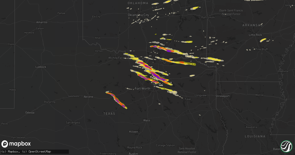
Hail Map on April 21, 2017
Get this storm
April 21 map
$229
one time, instant access
Download today. No call, no setup
Keep the $229
Bought the map and want the full workflow? Apply the entire $229 to a subscription within 7 days. None of it is wasted.
Every map, not just this one
This buys you this map. Subscription and you get every map we run, in the markets you choose from a few cities to whole states to nationwide. Plus real-time alerts the moment a storm fires.
Contact data
Name, contact info, occupancy, even credit band for addresses in the footprint. You go from where it hit to who to call.
Become the source they trust
Unlimited branding weather history reports on demand. You already have the documented answer ready for the property owner, and you are the one who showed up with it.
Property data and RoofTrace estimates
Pull up any address you have got, its value and the exact code rules for that jurisdiction, straight from One Click Code. Then RoofTrace estimates the squares, pitch, and roof value, priced the way you price.
States Impacted by Hail Map on April 21, 2017
Storm reports
Virginia
| Date | Description |
|---|---|
| 04/21/20176:36 PM CDT | Significant wind damage at monroe campground near colonial beach. |
| 04/21/20176:35 PM CDT | Half dollar sized hail and one to two foot diameter tree snapped. Neighbor's tree was uprooted. |
| 04/21/20176:26 PM CDT | A local report indicates 1.00 inch wind near COLONIAL BEACH |
| 04/21/20176:25 PM CDT | Several large trees and power lines downed along va-205 |
| 04/21/20176:24 PM CDT | Several trees down and campers damaged at monroe bay campground near colonial beach. |
| 04/21/20176:22 PM CDT | A local report indicates 1.00 inch wind near COLONIAL BEACH |
| 04/21/20176:20 PM CDT | Several large trees and power lines downed along va-205 |
| 04/21/20176:20 PM CDT | Half dollar sized hail and one to two foot diameter tree snapped. Neighbor's tree was uprooted. |
| 04/21/20176:17 PM CDT | Two trees down near intersection of va 205 and va 218 near gitiess |
| 04/21/20176:10 PM CDT | Tree down at round hill rd and round hill estate dr |
| 04/21/20176:07 PM CDT | Us 301 is closed to semi trucks between near va 205 due to low hanging power lines |
| 04/21/20176:07 PM CDT | Two trees down near intersection of md 205 and md 218 near gitiess |
| 04/21/20176:06 PM CDT | Trees and power lines down near intersection of lakeview drive and va 205 |
| 04/21/20176:05 PM CDT | Tractor trailer blown over |
| 04/21/20176:05 PM CDT | 20 tall trees down... Tree fell on minivan... Tree fell on back deck... 2 sheds damaged... Holes in house siding |
| 04/21/20176:05 PM CDT | Roof blown off shed and multiple trees adn power lines down |
| 04/21/20176:05 PM CDT | Trees through multiple trailers. One trailer appears to have blown off foundation. Multiple power lines down in trailer park |
| 04/21/20176:03 PM CDT | Trees through trailors |
| 04/21/20175:30 PM CDT | Tree down and dime size hail. |
| 04/21/20175:30 PM CDT | Tree down. |
| 04/20/20177:15 PM CDT | Numerous trees down around sandy point. |
| 04/20/20177:09 PM CDT | Numerous large trees down on skyview drive. Patio furniture and trampoline have also been blown away. |
| 04/20/20177:09 PM CDT | One inch diameter hail and small trees down on federal farm road. Caller may have seen a brief tornado or funnel cloud while giving report [looking toward mount holly]. |
Texas
| Date | Description |
|---|---|
| 04/21/20176:52 PM CDT | Egg size hail report 7 miles north of muenster |
| 04/21/20176:49 PM CDT | One inch report 8 miles north of muenster |
| 04/21/20176:26 PM CDT | Firefighter reports half dollar size hail near lake nocona. |
| 04/21/20176:18 PM CDT | One inch hail report approximately 8 miles north of nocona along the fm 1759 |
| 04/20/201711:28 PM CDT | Delayed report: social media report up to egg size hail in richardson |
| 04/20/201711:14 PM CDT | Amateur radio report: one inch hail report near richardson. |
| 04/20/201711:06 PM CDT | Delayed report: golfball size hail report in central plano. |
| 04/20/201711:04 PM CDT | Delayed report: egg size hail report 2 miles nnw of richardson. |
| 04/20/201711:00 PM CDT | Ping pong size hail report far north dallas. Preston rd and frankford rd |
| 04/20/201710:54 PM CDT | Half dollar size hail report near the dallas tollway and bush turnpike |
| 04/20/201710:47 PM CDT | Report of golfball size hail near hebron. King arthur blvd and n josey ln |
| 04/20/201710:40 PM CDT | Delayed report: social media report of baseball size hail south of gainesville |
| 04/20/201710:22 PM CDT | Delayed report: half dollar size hail in royse city |
| 04/20/201710:20 PM CDT | Delayed report: social media report of half dollar size hail near highland village |
| 04/20/201710:11 PM CDT | Delayed report: spotter report of quarter size hail in royse city |
| 04/20/201710:06 PM CDT | Half dollar size hail report 3 miles ssw of denton |
| 04/20/201710:06 PM CDT | Delayed report: quarter size hail report near robson ranch |
| 04/20/201710:00 PM CDT | Quarter size hail report in 156 and 380 west of denton |
| 04/20/20179:45 PM CDT | Delayed report: spotter report of ping pong size hail near telephone tx. |
| 04/20/20179:44 PM CDT | Delayed report: amateur radio reports golfball size hail in paris |
| 04/20/20179:44 PM CDT | Golfball size hail report in caddo mills |
| 04/20/20179:42 PM CDT | Report of golfball size hail near lamar. County road 32500 and fm 1499 |
| 04/20/20179:40 PM CDT | Delayed report -- quarter size hail reported via social media in josephine. |
| 04/20/20179:34 PM CDT | Spotter report: golfball size hail near dublin |
| 04/20/20179:04 PM CDT | Spotter report: quarter size hail 4 miles ssw of gainesville |
| 04/20/20179:04 PM CDT | Tennis ball size hail report near hwy 121 and us 75 |
| 04/20/20178:57 PM CDT | Quarter size hail report south of stephenville |
| 04/20/20178:57 PM CDT | Delayed report: quarter size hail report 3 miles nnw of allen |
| 04/20/20178:56 PM CDT | Spotter report of half dollar size hail near mckinney |
| 04/20/20178:52 PM CDT | Baseball size hail reported 2 miles w of mckinney |
| 04/20/20178:50 PM CDT | Social media report: egg size hail se of celina |
| 04/20/20178:47 PM CDT | Golfball size hail report in mckinney |
| 04/20/20178:45 PM CDT | Delayed report: trained spotter reports quarter sized hail near aledo... Tx. |
| 04/20/20178:43 PM CDT | Golfball size hail near prosper |
| 04/20/20178:41 PM CDT | Golfball size hail in celina |
| 04/20/20178:40 PM CDT | Baseball size hail report east of prosper |
| 04/20/20178:37 PM CDT | Golfball size hail report in lingleville fire station |
| 04/20/20178:35 PM CDT | Social media report of 2.50 inch hail near prosper/celina |
| 04/20/20178:29 PM CDT | 1.5 hail report from a spotter. |
| 04/20/20178:13 PM CDT | 60mph measured on the south side of lake roberts |
| 04/20/20177:57 PM CDT | Estimated wind gust of 60mph south of tioga. Near sh 377 at south county line |
| 04/20/20177:53 PM CDT | Quarter size hail report in ranger. |
| 04/20/20177:45 PM CDT | Spotter report: egg size hail 5 miles nw of tioga |
| 04/20/20177:30 PM CDT | Delayed report: social media report of ping pong size hail west of gainesville |
| 04/20/20177:27 PM CDT | Spotter report 1 inch hail 3 miles se of lindsay |
| 04/20/20177:27 PM CDT | Ping pong hail report 1 mile se of gainesville |
| 04/20/20177:27 PM CDT | Baseball size hail near i-35 south of gainesville. |
Oklahoma
| Date | Description |
|---|---|
| 04/21/20176:03 PM CDT | A local report indicates 1.25 inch wind near COLEMAN |
| 04/21/20175:30 PM CDT | A local report indicates 1.75 inch wind near 1 ESE RAVIA |
| 04/21/201712:25 PM CDT | Large tree limbs down |
| 04/21/201711:53 AM CDT | Trees uprooted |
| 04/21/201711:34 AM CDT | Large tree limbs down |
| 04/21/201711:20 AM CDT | Large tree limbs down |
| 04/21/201711:15 AM CDT | Report of roof blown off and tree damage. |
| 04/21/201711:10 AM CDT | A local report indicates 68 MPH wind near 4 W HECTORVILLE |
| 04/21/201711:10 AM CDT | 50-60 mph gust |
| 04/21/201711:06 AM CDT | Large tree limbs down |
| 04/21/201710:50 AM CDT | A local report indicates 64 MPH wind near 3 E OKEMAH |
| 04/21/201710:48 AM CDT | Tree down and barn badly damaged |
| 04/21/20179:32 AM CDT | Armstrong college |
| 04/21/20179:28 AM CDT | Se 44th/ i-35 |
| 04/21/20179:24 AM CDT | Cassidy school penn and britton. |
| 04/21/20179:22 AM CDT | Will rogers asos |
| 04/21/20179:15 AM CDT | A local report indicates 62 MPH wind near 2 ESE CHICKASHA |
| 04/21/20179:15 AM CDT | 10 power poles down. May ave between 63rd and wilshire |
| 04/21/20179:14 AM CDT | A local report indicates 77 MPH wind near CHICKASHA |
| 04/21/20179:05 AM CDT | A local report indicates 62 MPH wind near 2 SSW MINCO |
| 04/21/20178:22 AM CDT | A local report indicates 1.00 inch wind near 3 SE NORMAN |
| 04/20/201710:20 PM CDT | Damaged the sheriffs vehicle. |
| 04/20/201710:05 PM CDT | Facebook report of tree down across old 98 road. |
| 04/20/201710:05 PM CDT | Facebook report of quarter size hail via sheriff deputy. |
| 04/20/201710:00 PM CDT | Trees and power lines down. Roads blocked. |
| 04/20/20179:41 PM CDT | Power lines down |
| 04/20/20178:34 PM CDT | A local report indicates 1.00 inch wind near 3 E NASHOBA |
| 04/20/20177:00 PM CDT | Street light blown down and roof blown off a building onto vehicle. |
Maryland
| Date | Description |
|---|---|
| 04/21/20176:49 PM CDT | Quarter size hail |
| 04/21/20176:36 PM CDT | Significant boat damage reported at the colonial beach yacht center. |
| 04/21/20176:23 PM CDT | Significant boat/building damage reported at the colonial beach yacht center. |
| 04/21/20174:44 PM CDT | Tree down partially blocking the inner loop of capital beltway near md 355 |
| 04/21/20174:44 PM CDT | Half dollar size hail |
| 04/21/20174:40 PM CDT | Trees and wires down onto car at 700 block sligo creek parkway. Road blocked. |
| 04/21/20174:39 PM CDT | Tree and wires down onto 4500 block woodfield rd. Road being closed. |
| 04/21/20174:37 PM CDT | Large trees down on powerlines near the intersection of route 4 and old crain highway. |
| 04/21/20174:35 PM CDT | Tree into a house at 1100 block of merwood dr |
| 04/21/20174:33 PM CDT | Trees and wires down partially blocking intersection of university blvd west and connecticut ave |
| 04/21/20174:23 PM CDT | Trees and wires down at 11200 block of gainsborough rd |
| 04/21/20174:20 PM CDT | Half dozen large trees uprooted at 800 block jackson ave. One person with minor injuries. |
| 04/21/20174:15 PM CDT | Quarter size hail |
| 04/21/20174:15 PM CDT | Tree into a house at 300 block of ethan allen ave |
| 04/21/20174:12 PM CDT | Quarter size hail |
| 04/21/20174:09 PM CDT | Tree into house at 8500 block of lynwood place....major damage to the house |
| 04/21/20174:07 PM CDT | Tree branches down into left shoulder of capital beltway outer loop at exit 36 md 187 old georgetown rd |
| 04/21/20174:05 PM CDT | Quarter size hail |
| 04/21/20174:04 PM CDT | Trees and wires down blocking the intersection of carroll ave and grant ave |
| 04/21/20174:03 PM CDT | Quarter size hail |
| 04/21/20174:03 PM CDT | Tree into a house with wires down at 8550 connecticut avenue. Road partially blocked. |
| 04/21/20174:02 PM CDT | Tree branches and power pole down blocking the street near intersection of montrose ave and weymouth st |
| 04/21/20173:58 PM CDT | A local report indicates 1.75 inch wind near 1 NW TAKOMA PARK |
| 04/21/20173:57 PM CDT | Large tree uprooted... Possibly onto a house |
| 04/21/20173:55 PM CDT | A local report indicates 1.00 inch wind near 1 NW TAKOMA PARK |
| 04/21/20173:55 PM CDT | Sarbanes transit center |
| 04/21/20173:55 PM CDT | Several large tree branches and wires down blocking the entire road near intersection of seven locks rd and bells mill rd |
| 04/21/20173:54 PM CDT | A local report indicates 1.75 inch wind near 1 NW TAKOMA PARK |
| 04/21/20173:54 PM CDT | Tree into a house at 300 block of ethan allen ave |
| 04/21/20173:54 PM CDT | Tree into a house at 1100 block of merwood dr |
| 04/21/20173:54 PM CDT | Trees and wires down blocking the intersection of carroll ave and grant ave |
| 04/21/20173:53 PM CDT | Trees and wires down onto car at 700 block sligo creek parkway. Road blocked. |
| 04/21/20173:53 PM CDT | A local report indicates 1.25 inch wind near 1 NNW TAKOMA PARK |
| 04/21/20173:52 PM CDT | Quarter size hail at national weather service headquarters |
| 04/21/20173:52 PM CDT | Quarter size hail at 8528 piney branch rd |
| 04/21/20173:50 PM CDT | A local report indicates 1.25 inch wind near 1 NNW TAKOMA PARK |
| 04/21/20173:50 PM CDT | A local report indicates 1.50 inch wind near 1 W CHEVY CHASE |
| 04/21/20173:49 PM CDT | A local report indicates 1.00 inch wind near CHEVY CHASE |
| 04/21/20173:48 PM CDT | Quarter size hail at 8528 piney branch rd |
| 04/21/20173:47 PM CDT | Tree into house at 8500 block of lynwood place....major damage to the house |
| 04/21/20173:47 PM CDT | A local report indicates 1.50 inch wind near 1 W CHEVY CHASE |
| 04/21/20173:46 PM CDT | Tree into a house with wires down at 8550 connecticut avenue. Road partially blocked. |
| 04/21/20173:44 PM CDT | Large tree uprooted...possibly onto a house |
| 04/21/20173:43 PM CDT | Tree down partially blocking the inner loop of capital beltway near md 355 |
| 04/21/20173:43 PM CDT | Tree branches down into left shoulder of capital beltway outer loop just prior to exit 36 md 187 old georgetown rd. Two 8 to 12 inch diameter trees down adjacent to roa |
| 04/21/20173:43 PM CDT | Tree and wires down onto 4500 block woodfield rd. Road being closed. |
| 04/21/20173:43 PM CDT | Trees and wires down partially blocking intersection of university blvd west and connecticut ave |
| 04/21/20173:42 PM CDT | Quarter size hail |
| 04/21/20173:42 PM CDT | Tree branches and power pole down blocking the street near intersection of montrose ave and weymouth st |
| 04/21/20173:40 PM CDT | Several tree branches down onto wires in the 6300 block of haviland drive. |
| 04/21/20173:36 PM CDT | Several large tree branches and wires down blocking the entire road near intersection of seven locks rd and bells mill rd |
| 04/21/20173:34 PM CDT | Trees and wires down at 11200 block of gainsborough rd |
| 04/21/20173:32 PM CDT | Several tree branches down onto wires at the 6300 block of haviland drive |
| 04/20/201711:10 PM CDT | Golf ball size hail. Several large trees down. |
| 04/20/201711:10 PM CDT | Golf ball size hail. Several large trees down. |
| 04/20/20177:30 PM CDT | 3 trees blown down in a relaively small area. |
Arkansas
| Date | Description |
|---|---|
| 04/21/20178:18 AM CDT | Large tree limb reported down. |
| 04/21/20178:03 AM CDT | Several trees reported down throughout johnson county. Estimated wind speed 60-65 mph. |
| 04/21/20177:27 AM CDT | Hwy 23 blocked due to fallen trees. Location estimated via radar. |
| 04/21/201712:03 AM CDT | A local report indicates 1.00 inch wind near 3 E TOLLETTE |
| 04/20/201711:30 PM CDT | Facebook report of quarter size hail in the pennys community. |
Tennessee
| Date | Description |
|---|---|
| 04/21/20174:08 PM CDT | Trees down at highway 82 and coop road. |
| 04/21/20173:50 PM CDT | Image of roof damage to a commercial structure. |
| 04/21/20173:49 PM CDT | Minor damage to thomas magnet school. |
| 04/21/20173:48 PM CDT | Image of a large tree limb downed on courtland drive |
| 04/21/20172:08 PM CDT | Image of a hail stone in bradyville that was slightly larger than a quarter but smaller than a half dollar. |
| 04/21/20172:23 AM CDT | A couple of trees down on the road on sands ford road west of henning... Tennessee. Also more trees were down to the east of henning. |
District of Columbia
| Date | Description |
|---|---|
| 04/21/20174:07 PM CDT | Quarter size hail |
| 04/21/20174:02 PM CDT | Damage to roof shingles of house at 300 block hamilton st ne |
| 04/21/20174:02 PM CDT | Dime to quarter size hail |
| 04/21/20173:58 PM CDT | Dime to quarter size hail |
| 04/21/20173:58 PM CDT | Damage to roof shingles of house at 300 block hamilton st ne |
Cities Impacted by Hail Map on April 21, 2017
- Daisy, OK
- Sapulpa, OK
- Jenks, OK
- Kellyville, OK
- Bristow, OK
- Tecumseh, OK
- Shawnee, OK
- Mineral Springs, AR
- Lockesburg, AR
- Winthrop, AR
- Horatio, AR
- Saratoga, AR
- Cushing, OK
- Addison, TX
- Garland, TX
- Sunset, TX
- Dallas, TX
- Krum, TX
- Denton, TX
- Argyle, TX
- Richardson, TX
- Lake Dallas, TX
- The Colony, TX
- Lewisville, TX
- Alvord, TX
- Plano, TX
- Carrollton, TX
- Decatur, TX
- Justin, TX
- Bowie, TX
- Ponder, TX
- Newburg, MD
- Edmond, OK
- Wylie, TX
- Ringgold, TX
- Saint Jo, TX
- Muenster, TX
- Ryan, OK
- Nocona, TX
- Luttrell, TN
- Blaine, TN
- Mount Pleasant, TX
- Mount Vernon, TX
- Bagwell, TX
- Rattan, OK
- Nashoba, OK
- Snow, OK
- Wills Point, TX
- Terrell, TX
- Morris, OK
- Henryetta, OK
- Okmulgee, OK
- Kenefic, OK
- Coleman, OK
- Stuttgart, AR
- Carlisle, AR
- Weatherford, TX
- Charlotte Hall, MD
- La Plata, MD
- Paris, TX
- Blossom, TX
- Edgewood, TX
- Canton, TX
- Grand Saline, TX
- Chevy Chase, MD
- Bethesda, MD
- Takoma Park, MD
- Silver Spring, MD
- Kensington, MD
- Washington, DC
- Nacogdoches, TX
- Fort Towson, OK
- Sawyer, OK
- Sumner, TX
- Bokchito, OK
- Telephone, TX
- Honey Grove, TX
- Ivanhoe, TX
- Hendrix, OK
- Bennington, OK
- Caney, OK
- Caddo, OK
- Chesapeake Beach, MD
- Huntingtown, MD
- Sunderland, MD
- Owings, MD
- Dublin, TX
- Stephenville, TX
- Hague, VA
- Kinsale, VA
- King George, VA
- Colonial Beach, VA
- Montross, VA
- Pilot Point, TX
- Upper Marlboro, MD
- Mount Rainier, MD
- Bladensburg, MD
- Capitol Heights, MD
- Brentwood, MD
- Rockville, MD
- Hyattsville, MD
- District Heights, MD
- Kaufman, TX
- Ben Wheeler, TX
- Fruitvale, TX
- Humnoke, AR
- Rutledge, TN
- Beech Grove, AR
- Paragould, AR
- Walnut Ridge, AR
- Bono, AR
- Desdemona, TX
- Hico, TX
- Princeton, TX
- Ranger, TX
- Welcome, MD
- Faulkner, MD
- Bel Alton, MD
- Port Tobacco, MD
- Mechanicsville, MD
- Frisco, TX
- Celina, TX
- Prosper, TX
- Mckinney, TX
- Allen, TX
- Agra, OK
- Stroud, OK
- Mineral, VA
- Gum Spring, VA
- Sandy Hook, VA
- Bumpass, VA
- Beechgrove, TN
- Bell Buckle, TN
- Bradyville, TN
- Shelbyville, TN
- Readyville, TN
- Christiana, TN
- Calvin, OK
- Allen, OK
- Potomac, MD
- Gaithersburg, MD
- Mesquite, TX
- Forney, TX
- Sunnyvale, TX
- Nanjemoy, MD
- Pottsboro, TX
- Heavener, OK
- Breckenridge, TX
- Booneville, MS
- Maynardville, TN
- Haworth, OK
- Foreman, AR
- Norman, OK
- Oklahoma City, OK
- Marietta, OK
- Gainesville, TX
- Nevada, TX
- Caddo Mills, TX
- Royse City, TX
- Farmersville, TX
- Columbus, AR
- Poolesville, MD
- Germantown, MD
- Riverdale, MD
- Bowie, MD
- Lothian, MD
- Garrett Park, MD
- Lindsay, TX
- Valley View, TX
- Gunter, TX
- Anna, TX
- Celeste, TX
- Van Alstyne, TX
- Leonard, TX
- Collinsville, TX
- Blue Ridge, TX
- Tioga, TX
- Max Meadows, VA
- Wytheville, VA
- Tuttle, OK
- Issue, MD
- Little Elm, TX
- Murfreesboro, TN
- Coalgate, OK
- Muskogee, OK
- Blanchard, OK
- Amber, OK
- Tishomingo, OK
- Mill Creek, OK
- Alleene, AR
- Ashdown, AR
- Wilton, AR
- Norman, AR
- Boswell, OK
- Hartman, AR
- Sanger, TX
- Lavon, TX
- Quinlan, TX
- Greenville, TX
- Saint Joe, AR
- Yellville, AR
- Seminole, OK
- Cookson, OK
- Park Hill, OK
- Kingston, OK
- Cartwright, OK
- Calera, OK
- Mena, AR
- Bixby, OK
- Tulsa, OK
- Broken Arrow, OK
- Washington, OK
- Calico Rock, AR
- Madill, OK
- Clayton, OK
- Wartrace, TN
- Braggs, OK
- Welling, OK
- Sidney, AR
- Mountain View, AR
- Big Flat, AR
- Melbourne, AR
- Horseshoe Bend, AR
- Sage, AR
- Harriet, AR
- Flippin, AR
- Russellville, TN
- Whitesburg, TN
- Bulls Gap, TN
- Mohawk, TN
- Morristown, TN
- Bean Station, TN
- Cushing, TX
- Soper, OK
- Hugo, OK
- Era, TX
- Sparks, OK
- Chandler, OK
- Depew, OK
- Mineral Wells, TX
- Neavitt, MD
- Easton, MD
- Bozman, MD
- Sherwood, MD
- Saint Michaels, MD
- Royal Oak, MD
- Rosston, TX
- Detroit, TX
- Woodbury, TN
- Newalla, OK
- Bath Springs, TN
- Decaturville, TN
- Linden, TN
- Milburn, OK
- Fulton, AR
- Hope, AR
- Mcloud, OK
- England, AR
- Brookston, TX
- Vandervoort, AR
- Cove, AR
- Montague, TX
- Forestburg, TX
- Glenpool, OK
- Tryon, OK
- Atoka, OK
- Sulphur, OK
- Antlers, OK
- Ardmore, OK
- Valliant, OK
- Grant, OK
- Lane, OK
- Wapanucka, OK
- Idabel, OK
- Garvin, OK
- Centrahoma, OK
- Mounds, OK
- Gordonville, TX
- Corsicana, TX
- Leonardtown, MD
- Colbert, OK
- Lanham, MD
- Harwood, MD
- Washington, AR
- Ozan, AR
- Okemah, OK
- Durant, OK
- Tracys Landing, MD
- Sterling, VA
- College Park, MD
- Deale, MD
- Dunkirk, MD
- Okarche, OK
- Piedmont, OK
- Sadler, TX
- Ringold, OK
- Rockwall, TX
- Rowlett, TX
- Clarksville, TX
- Boynton, OK
- Stuart, OK
- Leola, AR
- Caddo, TX
- Harleton, TX
- Tilghman, MD
- Brandywine, MD
- Tishomingo, MS
- Everton, AR
- Bunch, OK
- Parsons, TN
- Sachse, TX
- Poughkeepsie, AR
- Evening Shade, AR
- De Leon, TX
- Jonesboro, AR
- Dahlgren, VA
- El Paso, AR
- Beebe, AR
- Mosheim, TN
- Mount Ida, AR
- Talihina, OK
- Watson, OK
- Henrietta, TX
- Burneyville, OK
- Wright City, OK
- Cisco, TX
- Pindall, AR
- Mount Pleasant, AR
- Marshall, AR
- Fifty Six, AR
- Valley Springs, AR
- Tupelo, OK
- Stonewall, OK
- Aubrey, TX
- Sheridan, AR
- Waurika, OK
- Prague, OK
- Indian Head, MD
- Fort Washington, MD
- Oxon Hill, MD
- Terral, OK
- Petrolia, TX
- Byers, TX
- Waldorf, MD
- Minco, OK
- Union City, OK
- Stillwater, OK
- Pomfret, MD
- Asher, OK
- Paden, OK
- Newcastle, OK
- Whitesboro, TX
- Grapevine, AR
- Millsap, TX
- Aledo, TX
- Melissa, TX
- Flower Mound, TX
- Powderly, TX
- Annona, TX
- Ravenna, TX
- Ada, OK
- Marbury, MD
- North Beach, MD