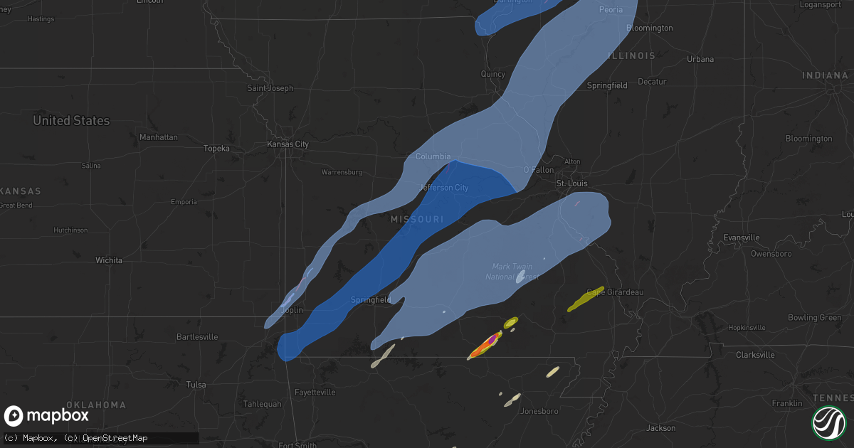
Hail Map in Missouri on April 20, 2025
Get this storm
April 20 map
$229
one time, instant access
Download today. No call, no setup
Keep the $229
Bought the map and want the full workflow? Apply the entire $229 to a subscription within 7 days. None of it is wasted.
Every map, not just this one
This buys you this map. Subscription and you get every map we run, in the markets you choose from a few cities to whole states to nationwide. Plus real-time alerts the moment a storm fires.
Contact data
Name, contact info, occupancy, even credit band for addresses in the footprint. You go from where it hit to who to call.
Become the source they trust
Unlimited branding weather history reports on demand. You already have the documented answer ready for the property owner, and you are the one who showed up with it.
Property data and RoofTrace estimates
Pull up any address you have got, its value and the exact code rules for that jurisdiction, straight from One Click Code. Then RoofTrace estimates the squares, pitch, and roof value, priced the way you price.
Storm reports in Missouri
Missouri
| Date | Description |
|---|---|
| 04/20/20256:59 PM CDT | Relayed via media. Size estimated from picture. Time estimated from radar. |
| 04/20/20256:38 PM CDT | From two sources west of hannibal... Mo. |
| 04/20/20256:35 PM CDT | Multiple reports of damage including trailers destroyed near hannibal regional hospital. |
| 04/20/20256:15 PM CDT | Damage to sheds. Damage to a support column and the wall of a home. |
| 04/20/20256:10 PM CDT | Vandalia mo ag site. |
| 04/20/20256:10 PM CDT | Estimated with near-zero visibility. |
| 04/20/20256:10 PM CDT | 2ft diameter tree snapped at the base. |
| 04/20/20255:51 PM CDT | Down tree on state highway n near graham cave state park. |
| 04/20/20255:33 PM CDT | At columbia-bradford mo ag site. |
| 04/20/20255:31 PM CDT | The nws surveyed straight line wind damage at a farm north-northwest of kingdom city. Photos provided by county law enforcement show extensive damage to multiple farm o |
| 04/20/20255:26 PM CDT | Corrects previous tstm wnd gst report from 7 ese columbia. At columbia-bradford mo ag site. |
| 04/20/20255:20 PM CDT | An outbuilding and a warehouse were significantly damaged... Per images. |
| 04/20/20255:20 PM CDT | Estimated winds. |
| 04/20/20255:19 PM CDT | Small outbuildings damaged. |
| 04/20/20255:18 PM CDT | Tree damage varying from downed limbs to uprooted trees. |
| 04/20/20255:18 PM CDT | Roof damage to parkade baptist church. |
| 04/20/20255:17 PM CDT | A local report indicates 66 MPH wind near 2 NE Jefferson City |
| 04/20/20255:16 PM CDT | A local report indicates 58 MPH wind near 3 NE Ashland |
| 04/20/20255:09 PM CDT | Multiple tree trunks snapped. |
| 04/20/20254:55 PM CDT | Large oak tree uprooted. Other smaller oak trees snapped. |
| 04/20/20254:50 PM CDT | A local report indicates 61 MPH wind near California |
| 04/20/20254:50 PM CDT | Damage to a barn at highway 38 and blue stem road. |
| 04/20/20254:45 PM CDT | Corrects previous tstm wnd dmg report from clarksburg. Multiple 6-8inch diameter tree limbs down. |
| 04/20/20254:45 PM CDT | Multiple 6-86inch diameter tree limbs down. |
| 04/20/20254:43 PM CDT | Tree down on state highway b. |
| 04/20/20254:43 PM CDT | Significant barn damage relayed to us at state highway d and bluebird road. Possible tornado. |
| 04/20/20254:43 PM CDT | Tree down in ava. |
| 04/20/20254:43 PM CDT | Barn destroyed. |
| 04/20/20254:40 PM CDT | Tree and powerline down on osage beach parkway. |
| 04/20/20254:40 PM CDT | Mesonet station gw3917 versailles. |
| 04/20/20254:40 PM CDT | Small shed destroyed at highway a and highway 5. |
| 04/20/20254:34 PM CDT | Tree down in goodhope area. |
| 04/20/20254:29 PM CDT | Public weather station measured 70.0 mph wind gust. |
| 04/20/20254:26 PM CDT | Several trees down. Tornado possible. |
| 04/20/20254:19 PM CDT | Trees down across the road. |
| 04/20/20254:17 PM CDT | Tree down across red bridge road. |
| 04/20/20254:15 PM CDT | Mesonet station fw9620 pumpkin center measured a 58mph wind gust. |
| 04/20/20254:14 PM CDT | Delayed report... Time estimated by radar. Tree across the roadway... Cant be moved by hand estimated 2ft diameter. |
| 04/20/20254:13 PM CDT | A large tree was uprooted and fell on a home and a shed was blown over. |
| 04/20/20254:10 PM CDT | A tiny home was rolled on its side. |
| 04/20/20254:10 PM CDT | An 8 inch tree down at highway 160 and highway 76 towards taneyville. |
| 04/20/20254:09 PM CDT | A five inch tree was down in forsyth. |
| 04/20/20254:08 PM CDT | Tree fell in seligman. |
| 04/20/20254:05 PM CDT | Trees and powerlines down. Tree down on a mobile home. |
| 04/20/20254:05 PM CDT | Large tree down. |
| 04/20/20254:02 PM CDT | Trees and powerlines down in hollister. |
| 04/20/20253:52 PM CDT | Asos station ksgf springfield asos measured 59mph wind gust. |
| 04/20/20253:25 PM CDT | Delayed report... Time estimated by radar. Tree limbs down on two vehicles and the corner of a house... Estimated tree size is around 1 to 1 and a half feet in diameter |
| 04/20/20253:20 PM CDT | Multiple trees down blocking road on highway ww. |
| 04/20/20253:16 PM CDT | Delayed report... Time estimated by radar. Line across 174 west of main. |
| 04/20/20253:12 PM CDT | Barn destroyed... Large trees down. Tornado possible. |
| 04/20/20253:10 PM CDT | Tree down south of state highway 96 on highway 97. |
| 04/20/20253:00 PM CDT | Numerous trees down across the monett area. |
| 04/20/20253:00 PM CDT | Corrects previous tstm wnd dmg report from olympia. Barn or shed destroyed. |
| 04/20/20253:00 PM CDT | Some powerlines down in monett. |
| 04/20/20253:00 PM CDT | Uprooted trees at state highway 97 and state highway cc. |
| 04/20/20252:57 PM CDT | Up to quarter size hail just south of wentworth. |
| 04/20/20252:50 PM CDT | Trees and powerlines down. Tornado possible. |
| 04/20/20252:39 PM CDT | Large tree and branches down on a house. Powerlines down. Tornado possible. |
| 04/20/20252:39 PM CDT | Roofs off storage buildings in east lamar. Possible tornado. |
| 04/20/20252:39 PM CDT | Tornado siren was blown down. Tornado possible. |
| 04/20/20252:39 PM CDT | Trees uprooted... Power poles down and broken... 3 inch limbs broken. Tornado possible. |
| 04/20/20252:38 PM CDT | Early reports coming in of trees and powerlines down in lamar. Damage assessment ongoing. Power out in town. Damage extends to the northeast of town. Possible tornado. |
| 04/20/20252:26 PM CDT | A public weather station measured a 68 mph gust 7 miles west southwest of goodman. |
| 04/20/20252:25 PM CDT | Barn destroyed and multiple power lines down. Tornado possible. |
| 04/20/20252:24 PM CDT | House and barn damage on county road 210 between thorn road and redbud road. |
| 04/20/20252:24 PM CDT | Barn is down west of jasper at highway h and highway o. |
| 04/20/20252:23 PM CDT | Trees downed and a damage to a barn. |
| 04/20/20252:17 PM CDT | Early reports coming in of several trees and powerlines down in carl junction. Some building damage as well. Possible tornado. |
| 04/20/20252:10 PM CDT | A roof off a house on county lane 265 and highway 96. |
| 04/20/20252:10 PM CDT | Corrects previous tstm wnd dmg report from carl junction. Early reports coming in of several trees and powerlines down in carl junction. Some building damage as well. P |
| 04/20/20252:10 PM CDT | A row of power poles snapped at ivy and county road 275 in carl junction. |
| 04/20/20252:07 PM CDT | A large 20x30 pavilion collapsed. |
| 04/20/20251:34 PM CDT | Corrects previous tstm wnd dmg report from 1 sw guthrie. Roof partially peeled off home. 18 to 20 inch diameter tree branches snapped from multiple trees about 3 to 4 f |
| 04/20/20251:34 PM CDT | Report of multiple trees sustaining damage of unknown extent. |
| 04/20/20251:34 PM CDT | Roof of house damaged. |
| 04/20/20251:31 PM CDT | An nws survey team found ef2 tornado damage on county road 362 northwest of new bloomfield. This track continued north-northeast until it intersected county road 347 an |
| 04/20/20251:31 PM CDT | Roof partially peeled off home. 18 to 20 inch diameter tree branches snapped from multiple trees about 3 to 4 feet from the ground. |
| 04/20/20257:11 AM CDT | Trees down one mile north of hwy 21 and hwy u. |
| 04/19/202511:23 PM CDT | Powerlines down at the corner of 6th street and eastwood. Time is radar estimated. |
| 04/19/20259:15 PM CDT | A large hardwood tree was uprooted and crushed a section of privacy fence and fell on riding mower. |
| 04/19/20259:14 PM CDT | A large 8 to 10 inch diameter limb fell on a vehicle. |
| 04/19/20259:12 PM CDT | Large hardwood tree was uprooted and fell on the corner of a 5th wheel camper causing minor damage. |
| 04/19/20259:10 PM CDT | A very large limb fell on carport and destroyed it. |
| 04/19/20257:50 PM CDT | Via trained spotter. |
| 04/19/20257:40 PM CDT | Powerlines down... Per em. |
| 04/19/20257:40 PM CDT | Power lines down at camilla st. And polk ave. Via em. |
| 04/19/20257:36 PM CDT | Power lines down in town. |
All States Impacted by Hail Map on April 20, 2025
Cities Impacted by Hail Map on April 20, 2025
- New Bloomfield, MO
- Fulton, MO
- Miami, OK
- Baxter Springs, KS
- Commerce, OK
- North Miami, OK
- Picher, OK
- Treece, KS
- Quapaw, OK
- Galena, KS
- Riverton, KS
- Carl Junction, MO
- Asbury, MO
- Joplin, MO
- Webb City, MO
- Oronogo, MO
- Neck City, MO
- Purcell, MO
- Jasper, MO
- Alba, MO
- Carthage, MO
- Jay, OK
- Gravette, AR
- South West City, MO
- Tiff City, MO
- Wyandotte, OK
- Anderson, MO
- Grove, OK
- Neosho, MO
- Seneca, MO
- Noel, MO
- Sulphur Springs, AR
- Goodman, MO
- Pineville, MO
- Lanagan, MO
- Lamar, MO
- Sheldon, MO
- Jerico Springs, MO
- Granby, MO
- Sarcoxie, MO
- Pierce City, MO
- Reeds, MO
- Stark City, MO
- Stella, MO
- Wheaton, MO
- Rocky Comfort, MO
- Fairview, MO
- Exeter, MO
- Monett, MO
- Wentworth, MO
- Purdy, MO
- El Dorado Springs, MO
- Milo, MO
- Stockton, MO
- La Russell, MO
- Stotts City, MO
- Miller, MO
- Mount Vernon, MO
- Osceola, MO
- Lowry City, MO
- Collins, MO
- Freistatt, MO
- Verona, MO
- Ash Grove, MO
- Marionville, MO
- Everton, MO
- Aurora, MO
- Salisbury, MO
- Springfield, MO
- Willard, MO
- Halltown, MO
- Bois D Arc, MO
- Republic, MO
- Billings, MO
- Clinton, MO
- Deepwater, MO
- Warsaw, MO
- Omaha, AR
- Alpena, AR
- Jessieville, AR
- Glenwood, AR
- Walnut Grove, MO
- South Greenfield, MO
- Morrisville, MO
- Aldrich, MO
- Bolivar, MO
- Louisburg, MO
- Urbana, MO
- Pleasant Hope, MO
- Buffalo, MO
- Brighton, MO
- Half Way, MO
- Strafford, MO
- Fair Grove, MO
- Marshfield, MO
- Elkland, MO
- Long Lane, MO
- Bonnerdale, AR
- Royal, AR
- Amity, AR
- Rueter, MO
- Cedarcreek, MO
- Kirbyville, MO
- Sunrise Beach, MO
- Osage Beach, MO
- Lebanon, MO
- Linn Creek, MO
- Camdenton, MO
- Macks Creek, MO
- Eldridge, MO
- Tunas, MO
- Windyville, MO
- Conway, MO
- Roach, MO
- Phillipsburg, MO
- Lake Ozark, MO
- Eldon, MO
- Montreal, MO
- Brumley, MO
- Stoutland, MO
- Tuscumbia, MO
- Kaiser, MO
- Bradleyville, MO
- Ava, MO
- Bismarck, AR
- Pearcy, AR
- Hot Springs National Park, AR
- Branson, MO
- Hollister, MO
- Rockaway Beach, MO
- Walnut Shade, MO
- Powersite, MO
- Forsyth, MO
- Oldfield, MO
- Seymour, MO
- Chadwick, MO
- Sparta, MO
- Garrison, MO
- Taneyville, MO
- Kissee Mills, MO
- Bruner, MO
- Fordland, MO
- Hartville, MO
- Grovespring, MO
- Mansfield, MO
- Niangua, MO
- Rogersville, MO
- Mountain Grove, MO
- Falcon, MO
- Norwood, MO
- Macomb, MO
- Drury, MO
- Lincoln, MO
- Cole Camp, MO
- Stover, MO
- Barnett, MO
- Versailles, MO
- Edwards, MO
- Syracuse, MO
- Tipton, MO
- Florence, MO
- Bunceton, MO
- Fortuna, MO
- Latham, MO
- Boonville, MO
- Clarksburg, MO
- Russellville, MO
- California, MO
- Prairie Home, MO
- Wooldridge, MO
- Jamestown, MO
- New Franklin, MO
- Fayette, MO
- Rocheport, MO
- Columbia, MO
- Ashland, MO
- Harrisburg, MO
- Hartsburg, MO
- Centertown, MO
- Lynchburg, MO
- Graff, MO
- Laquey, MO
- Richland, MO
- Waynesville, MO
- Crocker, MO
- Fort Leonard Wood, MO
- Plato, MO
- Dixon, MO
- Saint Robert, MO
- Huggins, MO
- Cabool, MO
- Bucyrus, MO
- Mountain View, MO
- Yukon, MO
- Newburg, MO
- Edgar Springs, MO
- Solo, MO
- Duke, MO
- Devils Elbow, MO
- Licking, MO
- Houston, MO
- Success, MO
- Summersville, MO
- Raymondville, MO
- Elk Creek, MO
- Willow Springs, MO
- Roby, MO
- Vanzant, MO
- Dora, MO
- Brixey, MO
- Wasola, MO
- Thornfield, MO
- Squires, MO
- Noble, MO
- Ulman, MO
- Eugene, MO
- Olean, MO
- Lohman, MO
- Jefferson City, MO
- Henley, MO
- Iberia, MO
- Holts Summit, MO
- Vienna, MO
- Saint Thomas, MO
- Saint Elizabeth, MO
- Bonnots Mill, MO
- Koeltztown, MO
- Westphalia, MO
- Linn, MO
- Freeburg, MO
- Meta, MO
- Loose Creek, MO
- Belle, MO
- Argyle, MO
- Brinktown, MO
- Tebbetts, MO
- Sturgeon, MO
- Hallsville, MO
- Benton City, MO
- Mexico, MO
- Kingdom City, MO
- Auxvasse, MO
- Thompson, MO
- Centralia, MO
- Martinsburg, MO
- Clark, MO
- Mokane, MO
- Chamois, MO
- Bland, MO
- Steedman, MO
- Malvern, AR
- Beulah, MO
- Vichy, MO
- Rolla, MO
- Lenox, MO
- Salem, MO
- Saint James, MO
- Jerome, MO
- Eunice, MO
- Eminence, MO
- Cuba, MO
- Jadwin, MO
- Hartshorn, MO
- Cook Sta, MO
- Paris, MO
- Center, MO
- Farber, MO
- Santa Fe, MO
- Rush Hill, MO
- Laddonia, MO
- New London, MO
- Perry, MO
- Vandalia, MO
- Wright City, MO
- Wellsville, MO
- High Hill, MO
- Warrenton, MO
- Bellflower, MO
- Montgomery City, MO
- Truesdale, MO
- Jonesburg, MO
- Middletown, MO
- New Florence, MO
- Curryville, MO
- Silex, MO
- Hawk Point, MO
- Frankford, MO
- Truxton, MO
- Bowling Green, MO
- Hermann, MO
- Rhineland, MO
- Williamsburg, MO
- Morrison, MO
- Mount Sterling, MO
- Portland, MO
- Berger, MO
- Marthasville, MO
- Owensville, MO
- Harrison, AR
- Green Forest, AR
- Benton, AR
- Steelville, MO
- Bourbon, MO
- Wesco, MO
- Cherryville, MO
- Leasburg, MO
- Boss, MO
- Bunker, MO
- Davisville, MO
- Viburnum, MO
- Ellington, MO
- Bixby, MO
- Louisiana, MO
- Troy, MO
- Eolia, MO
- New Canton, IL
- Kinderhook, IL
- Ashburn, MO
- Washington, MO
- Barry, IL
- New Haven, MO
- Leslie, MO
- Gerald, MO
- Rosebud, MO
- Salem, AR
- Rose Bud, AR
- Alton, MO
- Thayer, MO
- Koshkonong, MO
- Mammoth Spring, AR
- Jacksonville, AR
- Cabot, AR
- Vilonia, AR
- Austin, AR
- Potosi, MO
- Black, MO
- Centerville, MO
- Belleview, MO
- Hannibal, MO
- Plainville, IL
- Hull, IL
- Camp Point, IL
- Liberty, IL
- Golden, IL
- Pittsfield, IL
- Clayton, IL
- Rockport, IL
- Clarksville, MO
- Baylis, IL
- Pleasant Hill, IL
- New Salem, IL
- Elsberry, MO
- La Prairie, IL
- Timewell, IL
- Huntsville, IL
- Augusta, IL
- Foristell, MO
- Defiance, MO
- Carrollton, IL
- Hillview, IL
- Old Monroe, MO
- Lake Saint Louis, MO
- Batchtown, IL
- Winchester, IL
- Hardin, IL
- O'Fallon, MO
- Versailles, IL
- Milton, IL
- Winfield, MO
- Wentzville, MO
- Plymouth, IL
- Pearl, IL
- Hamburg, IL
- Augusta, MO
- Griggsville, IL
- White Hall, IL
- Kampsville, IL
- Moscow Mills, MO
- Camden, IL
- Brussels, IL
- Annada, MO
- Mount Sterling, IL
- Chambersburg, IL
- Fieldon, IL
- Patterson, IL
- Perry, IL
- Eldred, IL
- Nebo, IL
- Bluffs, IL
- Foley, MO
- Meredosia, IL
- Donnellson, IA
- Farmington, IA
- Wayland, MO
- Kahoka, MO
- Argyle, IA
- Fort Madison, IA
- West Point, IA
- Montrose, IA
- Nauvoo, IL
- Hamilton, IL
- Keokuk, IA
- Niota, IL
- Denmark, IA
- Wever, IA
- Middletown, IA
- West Burlington, IA
- Burlington, IA
- Sperry, IA
- Danville, IA
- Mediapolis, IA
- Carman, IL
- Lomax, IL
- Carthage, IL
- Dallas City, IL
- Couch, MO
- Fremont, MO
- Van Buren, MO
- Tenaha, TX
- Doniphan, MO
- Keithville, LA
- Bismarck, MO
- Concord, IL
- Industry, IL
- Littleton, IL
- Colchester, IL
- Vermont, IL
- Marietta, IL
- Adair, IL
- Astoria, IL
- Smithfield, IL
- Ipava, IL
- Chapin, IL
- Avon, IL
- Macomb, IL
- Frederick, IL
- Rushville, IL
- Roodhouse, IL
- Jacksonville, IL
- Bushnell, IL
- Arenzville, IL
- Table Grove, IL
- Browning, IL
- Beardstown, IL
- Ellisville, IL
- Bardolph, IL
- Prairie City, IL
- Bath, IL
- Pleasant Plains, IL
- Havana, IL
- Lewistown, IL
- Virginia, IL
- Chandlerville, IL
- Cuba, IL
- Murrayville, IL
- Alexander, IL
- Ashland, IL
- Sainte Genevieve, MO
- Berwick, IL
- Monmouth, IL
- Cameron, IL
- Oakville, IA
- Stronghurst, IL
- Oquawka, IL
- Gladstone, IL
- Smithville, AR
- Stonewall, LA
- Shreveport, LA
- Waterloo, IL
- Columbia, IL
- Millstadt, IL
- Belgrade, MO
- Dittmer, MO
- Fletcher, MO
- Caledonia, MO
- Blackwell, MO
- Richwoods, MO
- Lonedell, MO
- Grubville, MO
- Cadet, MO
- Sullivan, MO
- Lesterville, MO
- De Soto, MO
- Cedar Hill, MO
- Saint Louis, MO
- Hillsboro, MO
- Bonne Terre, MO
- Irondale, MO
- Barnhart, MO
- Festus, MO
- House Springs, MO
- Imperial, MO
- Pevely, MO
- Mineral Point, MO
- Arnold, MO
- Crystal City, MO
- Park Hills, MO
- East Carondelet, IL
- Herculaneum, MO
- Valmeyer, IL
- Chester, IL
- Saint Mary, MO
- Bloomsdale, MO
- Smithton, IL
- Arcadia, MO
- Baldwin, IL
- Evansville, IL
- Ironton, MO
- Ellis Grove, IL
- Red Bud, IL
- Middle Brook, MO
- New Athens, IL
- French Village, MO
- Prairie Du Rocher, IL
- Fredericktown, MO
- Modoc, IL
- Walsh, IL
- Leadwood, MO
- Farmington, MO
- Doe Run, MO
- Hecker, IL
- Valles Mines, MO
- Fults, IL
- Pilot Knob, MO
- Sparta, IL
- Annapolis, MO
- Redford, MO
- Alicia, AR
- Hoxie, AR
- Walnut Ridge, AR
- Lonoke, AR
- Carlisle, AR
- Des Arc, AR
- Hazen, AR
- Belleville, IL
- Freeburg, IL
- Lenzburg, IL
- Marissa, IL
- Tilden, IL
- Mascoutah, IL
- Coulterville, IL
- New Baden, IL
- Oakdale, IL
- Saint Libory, IL
- Okawville, IL
- Addieville, IL
- Cutler, IL
- Steeleville, IL
- Percy, IL
- Maquon, IL
- Oakford, IL
- Yates City, IL
- Petersburg, IL
- Farmington, IL
- Williamsfield, IL
- Kilbourne, IL
- Tallula, IL
- Easton, IL
- Brimfield, IL
- Liverpool, IL
- Saint David, IL
- Bryant, IL
- Elmwood, IL
- London Mills, IL
- Topeka, IL
- Fairview, IL
- Canton, IL
- Norris, IL
- Hanna City, IL
- Speer, IL
- Dunlap, IL
- Manito, IL
- Glasford, IL
- Wyoming, IL
- Mapleton, IL
- Laura, IL
- Forest City, IL
- Trivoli, IL
- Princeville, IL
- Edwards, IL
- Kingston Mines, IL
- Peoria, IL
- Bradford, IL
- San Jose, IL
- Groveland, IL
- Mason City, IL
- New Holland, IL
- Armington, IL
- Hopedale, IL
- Delavan, IL
- Deer Creek, IL
- Peoria Heights, IL
- Minier, IL
- Greenview, IL
- Creve Coeur, IL
- East Peoria, IL
- South Pekin, IL
- Mossville, IL
- Emden, IL
- Washington, IL
- Tremont, IL
- Chillicothe, IL
- Metamora, IL
- Mackinaw, IL
- Morton, IL
- Edelstein, IL
- Hartsburg, IL
- Green Valley, IL
- Sparland, IL
- Pekin, IL
- Stanford, IL
- Washburn, IL
- Henry, IL
- Eureka, IL
- Lacon, IL
- Lowpoint, IL
- Roanoke, IL
- Danvers, IL
- Goodfield, IL
- Varna, IL
- Congerville, IL
- Aledo, IL
- Wapello, IA
- Joy, IL
- Keithsburg, IL
- New Boston, IL
- Reynolds, IL
- Seaton, IL
- Taylor Ridge, IL
- Milan, IL
- Rock Island, IL
- Pleasant Valley, IA
- Coal Valley, IL
- Hampton, IL
- Moline, IL
- Le Claire, IA
- Silvis, IL
- East Moline, IL
- Bettendorf, IA
- Little York, IL
- Sherrard, IL
- Raritan, IL
- Victoria, IL
- Port Byron, IL
- Bishop Hill, IL
- Hillsdale, IL
- Altona, IL
- Orion, IL
- East Galesburg, IL
- Knoxville, IL
- Annawan, IL
- Galva, IL
- Biggsville, IL
- Dahinda, IL
- Woodhull, IL
- Media, IL
- New Windsor, IL
- Kirkwood, IL
- Andover, IL
- Carbon Cliff, IL
- Toulon, IL
- Rapids City, IL
- Matherville, IL
- Abingdon, IL
- Henderson, IL
- Atkinson, IL
- Alexis, IL
- Wataga, IL
- Rio, IL
- Roseville, IL
- La Fayette, IL
- Galesburg, IL
- Kewanee, IL
- Geneseo, IL
- Alpha, IL
- Osco, IL
- Gerlaw, IL
- Neponset, IL
- Lynn Center, IL
- Cambridge, IL
- Smithshire, IL
- Viola, IL
- Ophiem, IL
- Colona, IL
- La Harpe, IL
- North Henderson, IL
- Oneida, IL
- Gilson, IL
- Blandinsville, IL
- Sciota, IL
- Saint Augustine, IL
- Erie, IL
- Prophetstown, IL
- Sheffield, IL
- Mineral, IL
- Hooppole, IL
- Buda, IL
- Tampico, IL
- Knobel, AR
- Paragould, AR
- Lafe, AR
- Delaplaine, AR
- Rector, AR
- Piggott, AR
- Corning, AR
- Haynesville, LA
- Zalma, MO
- Pine Bluff, AR
- Toluca, IL
- La Rose, IL
- Magnolia, IL
- Benson, IL
- Minonk, IL
- Secor, IL
- Wappapello, MO
- Gipsy, MO
- McGee, MO
- Marble Hill, MO
- Leopold, MO
- Burfordville, MO
- Whitewater, MO
- Jackson, MO
- Cape Girardeau, MO
- Emerson, AR
- Brinkley, AR
- Moro, AR
- Birch Tree, MO
- Fayetteville, AR


