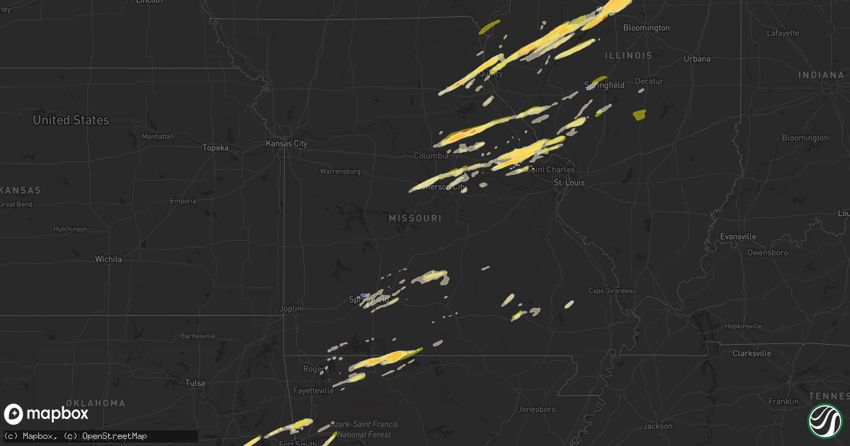
Hail Map in Missouri on April 20, 2023
Get this storm
April 20 map
$229
one time, instant access
Download today. No call, no setup
Keep the $229
Bought the map and want the full workflow? Apply the entire $229 to a subscription within 7 days. None of it is wasted.
Every map, not just this one
This buys you this map. Subscription and you get every map we run, in the markets you choose from a few cities to whole states to nationwide. Plus real-time alerts the moment a storm fires.
Contact data
Name, contact info, occupancy, even credit band for addresses in the footprint. You go from where it hit to who to call.
Become the source they trust
Unlimited branding weather history reports on demand. You already have the documented answer ready for the property owner, and you are the one who showed up with it.
Property data and RoofTrace estimates
Pull up any address you have got, its value and the exact code rules for that jurisdiction, straight from One Click Code. Then RoofTrace estimates the squares, pitch, and roof value, priced the way you price.
Storm reports in Missouri
Missouri
| Date | Description |
|---|---|
| 04/20/20235:47 PM CDT | Pea sized hail fell for a period of 8 minutes with a brief period of hail around the size of quarters. Observation was taken off of wilmer valley drive. |
| 04/20/20235:07 PM CDT | Two separate reports of dime to quarter size hail in van buren. Report relayed by emergency management. |
| 04/20/20234:31 PM CDT | Report from mping: quarter |
| 04/20/20234:30 PM CDT | A local report indicates 1.75 inch wind near 2 S PROTEM |
| 04/20/20234:28 PM CDT | A local report indicates 1.50 inch wind near 2 WNW MOSCOW MILLS |
| 04/20/20234:26 PM CDT | Report from mping: ping pong ball |
| 04/20/20234:24 PM CDT | Viewer picture of slightly bigger than quarter size hail in wright city. Time based on radar. |
| 04/20/20234:17 PM CDT | A local report indicates 1.75 inch wind near 3 NNE WARRENTON |
| 04/20/20234:15 PM CDT | Damage: broken window and damaged deck. |
| 04/20/20234:05 PM CDT | A local report indicates 1.00 inch wind near 3 WNW WINFIELD |
| 04/20/20234:04 PM CDT | A local report indicates 1.75 inch wind near 1 NE TROY |
| 04/20/20234:02 PM CDT | Report from mping: quarter |
| 04/20/20233:58 PM CDT | Report from mping: quarter |
| 04/20/20233:57 PM CDT | Report from mping: quarter |
| 04/20/20233:56 PM CDT | A local report indicates 1.25 inch wind near TROY |
| 04/20/20233:56 PM CDT | A local report indicates 1.75 inch wind near 1 E TROY |
| 04/20/20233:56 PM CDT | Report from mping: half dollar |
| 04/20/20233:55 PM CDT | A local report indicates 1.50 inch wind near TROY |
| 04/20/20233:55 PM CDT | A local report indicates 1.00 inch wind near TROY |
| 04/20/20233:54 PM CDT | A local report indicates 1.00 inch wind near 1 NNW TROY |
| 04/20/20233:53 PM CDT | A local report indicates 60 MPH wind near TROY |
| 04/20/20233:49 PM CDT | A local report indicates 1.00 inch wind near 3 SSW CAVE |
| 04/20/20233:09 PM CDT | A local report indicates 1.00 inch wind near PLATO |
| 04/20/20232:47 PM CDT | A local report indicates 1.00 inch wind near WELLSVILLE |
| 04/20/20232:44 PM CDT | Nickel to quarter size hail in fordland. |
| 04/20/20232:44 PM CDT | Nickel to quarter size hail in fordland. |
| 04/20/20232:17 PM CDT | A local report indicates 1.00 inch wind near 5 SE CARRINGTON |
| 04/20/20232:14 PM CDT | Via social media. Time estimated using radar. |
| 04/20/20232:08 PM CDT | Reported at shell oil. Nickle to quarter size reported. |
| 04/20/20232:05 PM CDT | A local report indicates 1.00 inch wind near FARBER |
| 04/20/20232:05 PM CDT | A local report indicates 1.00 inch wind near LADDONIA |
| 04/20/20232:05 PM CDT | A local report indicates 1.25 inch wind near 1 N FARBER |
| 04/20/20232:04 PM CDT | A local report indicates 1.25 inch wind near LADDONIA |
| 04/20/20232:00 PM CDT | A local report indicates 1.50 inch wind near LA GRANGE |
| 04/20/20231:59 PM CDT | Report from mping: quarter |
| 04/20/20231:58 PM CDT | A local report indicates 1.75 inch wind near LADDONIA |
| 04/20/20231:56 PM CDT | A local report indicates 1.00 inch wind near LA GRANGE |
| 04/20/20231:48 PM CDT | Electric poles snapped and down with pea size hail. |
| 04/20/20231:45 PM CDT | A local report indicates 1.75 inch wind near 1 WNW MEXICO |
| 04/20/20231:42 PM CDT | A local report indicates 1.75 inch wind near 1 NNW MEXICO |
| 04/20/20231:42 PM CDT | A local report indicates 1.50 inch wind near 1 NW MEXICO |
| 04/20/20231:42 PM CDT | A local report indicates 1.50 inch wind near MEXICO |
| 04/20/20231:42 PM CDT | 8-12 inch diameter tree limbs blown down. |
| 04/20/20231:40 PM CDT | A local report indicates 1.00 inch wind near 1 W MEXICO |
| 04/20/20231:40 PM CDT | Report from mping: quarter |
| 04/20/20231:40 PM CDT | A local report indicates 1.75 inch wind near 2 WSW MEXICO |
| 04/20/20231:29 PM CDT | A local report indicates 1.75 inch wind near 2 N EMDEN |
| 04/20/20231:14 PM CDT | Asos station ksgf springfield asos. |
All States Impacted by Hail Map on April 20, 2023
Cities Impacted by Hail Map on April 20, 2023
- Blanchard, OK
- Oklahoma City, OK
- Purcell, OK
- Washington, OK
- Elk Point, SD
- Mount Sterling, IL
- Versailles, IL
- Palmyra, MO
- Basco, IL
- New London, MO
- Hannibal, MO
- Hallsville, MO
- Centralia, MO
- Thompson, MO
- Mexico, MO
- Russellville, MO
- California, MO
- Rush Hill, MO
- Laddonia, MO
- Centertown, MO
- Jefferson City, MO
- Ewing, MO
- Philadelphia, MO
- Maywood, MO
- Durham, MO
- La Grange, MO
- Clayton, OK
- Springfield, MO
- Nashoba, OK
- Farber, MO
- Mullin, TX
- Zephyr, TX
- Comanche, TX
- Priddy, TX
- Vandalia, MO
- Quincy, IL
- Ursa, IL
- Fowler, IL
- Albion, OK
- Mendon, IL
- Paloma, IL
- Coatsburg, IL
- Curryville, MO
- Gustine, TX
- Loraine, IL
- Argyle, IA
- Wayland, MO
- Keokuk, IA
- Montrose, IA
- Trenton, TX
- Whitewright, TX
- Bonham, TX
- Randolph, TX
- Leonard, TX
- Rowlett, TX
- Honobia, OK
- Camp Point, IL
- Golden, IL
- Rockwall, TX
- Nauvoo, IL
- Niota, IL
- Ravenna, TX
- Ivanhoe, TX
- La Prairie, IL
- Bowen, IL
- Bowling Green, MO
- Cleburne, TX
- Grandview, TX
- Louisiana, MO
- Alvarado, TX
- Hartsburg, MO
- New Bloomfield, MO
- Porum, OK
- Fulton, MO
- Mokane, MO
- Steedman, MO
- Williamsburg, MO
- Hamilton, TX
- Pottsville, TX
- Augusta, IL
- Plymouth, IL
- Stigler, OK
- Vian, OK
- Webbers Falls, OK
- Wolfe City, TX
- Ladonia, TX
- Wellsville, MO
- Huntsville, IL
- Dodd City, TX
- Windom, TX
- Honey Grove, TX
- Whitesboro, OK
- Mesquite, TX
- Dallas, TX
- Balch Springs, TX
- Fordland, MO
- Seymour, MO
- Sunnyvale, TX
- Falcon, MO
- Evant, TX
- Jonesboro, TX
- Lynchburg, MO
- Mountain Grove, MO
- Plato, MO
- Roby, MO
- Sallisaw, OK
- Littleton, IL
- Industry, IL
- Colchester, IL
- Macomb, IL
- Muldrow, OK
- Roxton, TX
- Sherrard, IL
- Orion, IL
- Lynn Center, IL
- Forney, TX
- Green Forest, AR
- Pleasant Hill, IL
- Nebo, IL
- Pittsfield, IL
- Pearl, IL
- Osco, IL
- Coal Valley, IL
- Geneseo, IL
- Omaha, AR
- Itasca, TX
- Uniontown, AR
- Petty, TX
- Van Buren, AR
- Cedarville, AR
- Natural Dam, AR
- Warrenton, MO
- Hawk Point, MO
- Gatesville, TX
- Chester, AR
- Galesburg, IL
- Wataga, IL
- Oneida, IL
- Milford, TX
- Oglesby, TX
- Altona, IL
- San Saba, TX
- Adair, IL
- Table Grove, IL
- Marietta, IL
- Smithfield, IL
- Cuba, IL
- Vermont, IL
- Terrell, TX
- Crandall, TX
- Brookston, TX
- Paris, TX
- Ipava, IL
- Lewistown, IL
- Canton, IL
- Troy, MO
- Winfield, MO
- Foley, MO
- Moscow Mills, MO
- Prophetstown, IL
- Galva, IL
- Kewanee, IL
- Wright City, MO
- Neponset, IL
- Leander, TX
- Sheffield, IL
- Toulon, IL
- Lead Hill, AR
- Protem, MO
- Cedarcreek, MO
- Buda, IL
- Bethel, OK
- Commerce, TX
- Klondike, TX
- Pattonville, TX
- Deport, TX
- Uvalde, TX
- Brackettville, TX
- Yellville, AR
- Peel, AR
- Theodosia, MO
- Brodhead, WI
- Evansville, WI
- Tiskilwa, IL
- Wyanet, IL
- Princeton, IL
- Edgerton, WI
- Stoughton, WI
- Cambridge, WI
- Peoria, IL
- Mapleton, IL
- Bogata, TX
- Glasford, IL
- East Peoria, IL
- Peoria Heights, IL
- Berryville, AR
- Huntsville, AR
- Moody, TX
- McGregor, TX
- Alpena, AR
- Creve Coeur, IL
- Washington, IL
- Eddy, TX
- Bruceville, TX
- Lampasas, TX
- Lometa, TX
- Pontiac, MO
- Oakland, AR
- Isabella, MO
- Kaufman, TX
- Metamora, IL
- Dover, IL
- Malden, IL
- Kerrville, TX
- La Moille, IL
- Arlington, IL
- Comfort, TX
- Mendota, IL
- Eureka, IL
- Gainesville, MO
- Manito, IL
- Kingston Mines, IL
- Pekin, IL
- Jonesburg, MO
- Lowpoint, IL
- Old Monroe, MO
- Brussels, IL
- Batchtown, IL
- Roanoke, IL
- Benson, IL
- Washburn, IL
- Fredericksburg, TX
- Copperas Cove, TX
- Kempner, TX
- Fieldon, IL
- Hardin, IL
- Fort Hood, TX
- Browning, IL
- Chilton, TX
- Jerseyville, IL
- Kane, IL
- Medora, IL
- Astoria, IL
- Havana, IL
- Bath, IL
- Menard, TX
- Van Buren, MO
- Brady, TX
- Royse City, TX
- Rockford, IL
- Caddo Mills, TX
- Greenville, TX
- Melvin, TX
- Pleasant Plains, IL
- Springfield, IL
- Loves Park, IL
- Cantrall, IL
- Sherman, IL
- Caledonia, IL
- Machesney Park, IL
- Minonk, IL
- Poplar Grove, IL
- Dana, IL
- Capron, IL
- Varna, IL
- Elburn, IL
- Wasco, IL
- Saint Charles, IL
- Easton, IL
- Topeka, IL
- Forest City, IL
- South Elgin, IL
- Elgin, IL
- Bartlett, IL
- Eldorado, TX
- Dundee, IL
- Barrington, IL
- Hoffman Estates, IL
- Kemp, TX
- Silex, MO
- Biggsville, IL
- Rushville, IL
- Loami, IL
- Waverly, IL
- Auburn, IL
- Niangua, MO
- Marshfield, MO
- Leaf River, IL
- German Valley, IL
- Elkland, MO
- Dixon, IL
- Amboy, IL
- Harmon, IL
- Eldena, IL
- Franklin Grove, IL
- Liverpool, IL
- Eureka Springs, AR
- Phillipsburg, MO
- Conway, MO
- Marthasville, MO
- Elsberry, MO
- Carthage, IL
- Savanna, IL
- Thomson, IL
- Vanzant, MO
- Milan, IL
- Rudy, AR
- Salem, MO
- Montgomery City, MO
- Henderson, IL
- La Fayette, IL
- Arlington, TX
- Grand Prairie, TX
- Bushnell, IL
- Bellflower, MO
- Canton, MO
- Columbia, MO
- Auxvasse, MO
- Ellington, MO
- Viola, IL
- Winnebago, IL
- Byron, IL
- Branson, MO
- Modesto, IL
- Virden, IL
- Rhineland, MO
- Portland, MO
- Jacksonville, IL
- Murrayville, IL
- Winchester, IL
- Franklin, IL
- Forreston, IL
- Dora, MO
- Tecumseh, MO
- Caulfield, MO
- Harrison, AR
- Garfield, AR
- Morrison, IL
- Lanark, IL
- Polo, IL
- Milledgeville, IL
- Shannon, IL
- Seligman, MO
- Hartville, MO
- Rockbridge, IL
- Morocco, IN
- Hillsdale, IL
- Sterling, IL
- Piedmont, MO
- Ellsinore, MO
- Success, MO
- Grovespring, MO
- Bucyrus, MO
- Reynolds, IL
- Aledo, IL
- Smithville, OK
- Reeds Spring, MO
- Goldthwaite, TX
- Chadwick, IL
- Seagoville, TX
- Woodway, TX
- Rogers, AR
- Matherville, IL
- Atkinson, IL
- Keithsburg, IL
- New Windsor, IL
- Seaton, IL
- Joy, IL
- Winona, MO
- Martinsburg, MO
- New Florence, MO
- Watson, OK
- Broken Bow, OK
- Haworth, OK
- West Point, IL
- Shelbyville, MO
- Emden, MO
- Monroe City, MO
- Bettendorf, IA
- Davenport, IA
- Rock Island, IL
- Bend, TX
- Ava, MO
- Truxton, MO
- Foristell, MO
- Hindsville, AR
- Little York, IL
- Alexis, IL
- Monmouth, IL
- Oquawka, IL
- Cassville, MO
- Eagle Rock, MO
- Shell Knob, MO
- Tebbetts, MO
- Pecan Gap, TX
- Cooper, TX
- Ben Franklin, TX
- Lohman, MO
- Mulberry, AR
- Strafford, MO
- Republic, MO
- Brookline, MO
- Willow Springs, MO
- Ozark, MO
- Nixa, MO
- Rio, IL
- Richland Springs, TX
- Rogersville, MO
- Crawford, TX
- Hermann, MO
- Tarpley, TX
- Hugo, OK
- Medina, TX
- Bandera, TX
- Mena, AR
- Hatfield, AR
- Rattan, OK
- Mountainburg, AR
- Savoy, TX
- Deer Grove, IL
- Tampico, IL
- Quinlan, TX
- Garland, TX
- Fremont, MO
- Snow, OK
- Fort McKavett, TX
- Benton City, MO
- Cabool, MO
- Saint David, IL
- Camden, IL
- Bryant, IL
- Chamois, MO
- Holts Summit, MO
- Bonnots Mill, MO
- Purmela, TX
- Hillview, IL
- Shelbina, MO
- Valley Mills, TX
- White Hall, IL
- Kampsville, IL
- Alpha, IL
- Ophiem, IL
- Timewell, IL
- Clarence, MO
- Clayton, IL
- Lentner, MO
- Trivoli, IL
- Daisy, OK
- Latham, MO
- High Hill, MO
- Barnett, MO
- Wentzville, MO
- Taylor, MO
- O'Fallon, MO
- Lake Saint Louis, MO
- Sabinal, TX
- Grafton, IL
- Dow, IL
- Willow City, TX
- Lake Zurich, IL
- Palatine, IL
- Mabank, TX
- Dike, TX
- Burnet, TX
- Sulphur Bluff, TX
- Canton, TX
- Mount Vernon, TX
- Talco, TX
- Rio Medina, TX
- San Antonio, TX
- Mico, TX
- Franklin, WI
- Greendale, WI
- Milwaukee, WI
- Mount Pleasant, TX
- Schaumburg, IL
- Streamwood, IL
- Arlington Heights, IL
- Buffalo Grove, IL
- Wheeling, IL
- Mooseheart, IL
- North Aurora, IL
- Batavia, IL
- Geneva, IL
- West Chicago, IL
- Warrenville, IL
- Wayne, IL
- Carol Stream, IL
- Roselle, IL
- Hanover Park, IL
- Bloomingdale, IL
- Northbrook, IL
- Glenview, IL
- Liberty Hill, TX
- Georgetown, TX
- Winnetka, IL
- Glencoe, IL
- Elk Grove Village, IL
- Medinah, IL
- Rolling Meadows, IL
- Mount Prospect, IL
- Glendale Heights, IL
- Winfield, IL
- Itasca, IL
- Prospect Heights, IL
- Des Plaines, IL
- Tyler, TX
- Verona, IL
- Morris, IL
- Mazon, IL
- Minooka, IL
- Wilmington, IL
- Channahon, IL
- Elwood, IL
- Dwight, IL
- Gardner, IL
- South Wilmington, IL
- Reddick, IL
- Essex, IL
- Bonfield, IL
- Kankakee, IL
- Manteno, IL
- Bourbonnais, IL
- Owaneco, IL
- Pana, IL
- Assumption, IL
- Caldwell, TX
- Hearne, TX
- Texarkana, TX
- Hooks, TX
- Nash, TX
- Harper, TX
- Jbsa Ft Sam Houston, TX
- Jbsa Lackland, TX
- Winona, TX
- Ozark, AR
- Cecil, AR
- Mountain Home, TX
- Bastrop, TX
- Paige, TX
- Smithville, TX
- West Point, TX
- Euless, TX
- Fort Worth, TX
- Iredell, TX
- Walnut Springs, TX
- Irving, TX
- Morgan, TX
- Kopperl, TX
- Carrollton, TX
- Addison, TX
- Rocksprings, TX
- Leakey, TX
- Hunt, TX
- Plano, TX
- La Grange, TX
- Talihina, OK
- Muse, OK
- Hodgen, OK
- Heavener, OK
- Allen, TX
- Rio Vista, TX
- Glen Rose, TX
- Libertyville, IL
- Lake Forest, IL
- Hampshire, IL
- Caledonia, WI
- Oak Creek, WI
- Sycamore, IL
- Genoa, IL
- Van Alstyne, TX
- Baileyville, IL
- Crystal Lake, IL
- Lake In The Hills, IL
- Cary, IL
- Horseshoe Bay, TX
- Llano, TX
- Mount Morris, IL
- Fox River Grove, IL
- Carpentersville, IL
- Algonquin, IL
- Gilberts, IL
- Huntley, IL
- New Berlin, IL
- Paron, AR
- Lonsdale, AR
- Hot Springs Village, AR
- Mundelein, IL
- Grayslake, IL
- Round Lake, IL
- Fort Smith, AR
- Charleston, AR
- Kilbourne, IL
- Beardstown, IL
- Granger, TX
- Hillsboro, TX
- Green Valley, IL
- Elgin, TX
- Dekalb, IL
- Hinckley, IL
- Waterman, IL
- Palmyra, IL
- Hettick, IL
- Killeen, TX
- Rosebud, TX
- Burlington, TX
- Blue Mound, IL
- Macon, IL
- Hales Corners, WI
- Saint Francis, WI
- Muskego, WI
- Ben Wheeler, TX
- Mill Spring, MO
- Little Rock, AR
- Sandwich, IL
- Earlville, IL
- Leland, IL
- Somonauk, IL
- Linn, MO
- Richards, TX
- Bedias, TX
- Huntsville, TX
- Frederick, IL
- Jarrell, TX
- Holland, TX
- Austin, TX
- Cedar Park, TX
- Florence, TX
- Troy, TX
- Lott, TX
- Temple, TX
- Carlinville, IL
- Carrollton, IL
- Chesterfield, IL
- Greenfield, IL
- Maud, TX
- Murchison, TX
- Rock Falls, IL
- Anna, TX
- Highland Park, IL
- D Hanis, TX
- Wilmette, IL
- Niles, IL
- Wood Dale, IL
- Mineral, IL
- Haltom City, TX
- Pipe Creek, TX
- Park Ridge, IL
- Bensenville, IL
- Bartlett, TX
- Greenwood, AR
- Huntington, AR
- Wister, OK
- Bells, TX
- Voca, TX
- Johnson City, TX
- Telephone, TX
- Ashton, IL
- Deerfield, IL
- Waco, TX
- Bertram, TX
- Stonewall, TX
- Ohio, IL
- Sublette, IL
- Gause, TX
- Milano, TX
- Jessieville, AR
- Belton, TX
- Buckholts, TX
- Davilla, TX
- Rockdale, TX
- Cameron, TX
- Lorena, TX
- Manor, TX
- Pflugerville, TX
- Round Mountain, TX
- Malta, IL
- Tom Bean, TX
- Taylor, TX
- Girard, IL
- College Station, TX
- Bryan, TX
- Blue Ridge, TX
- Ector, TX
- Scurry, TX
- Wills Point, TX
- Marble Falls, TX
- Kingsland, TX
- Junction, TX
- Doss, TX
- Somerville, TX
- Helotes, TX
- Kinsman, IL
- Colleyville, TX
- Lewisville, TX
- Hurst, TX
- Coppell, TX
- Bedford, TX
- North Richland Hills, TX
- Grapevine, TX
- Center Point, TX
- Utopia, TX
- Blackstone, IL
- Cornell, IL
- Hanna City, IL
- Rogers, TX
- Thorndale, TX
- Abbott, TX
- Hondo, TX
- Lincolnshire, IL
- Vernon Hills, IL
- Salado, TX
- Spicewood, TX
- Farmersville, IL
- Divernon, IL
- Pawnee, IL
- Boswell, OK
- Gipsy, MO
- Zalma, MO
- Golden Eagle, IL
- Morton, IL
- Maple Park, IL
- Highwood, IL
- New Boston, TX
- Marlin, TX
- Alexander, IL
- Franklin, TX
- Aquilla, TX
- Lowndes, MO
- Wappapello, MO
- Buchanan Dam, TX
- Ransom, IL
- Streator, IL
- Bennington, OK
- Rutland, IL
- Long Point, IL
- Ancona, IL
- Pontiac, IL
- Elmendorf, TX
- McGee, MO
- Lake Creek, TX
- Anderson, TX
- Harker Heights, TX
- Nolanville, TX
- Reagan, TX
- Briggs, TX
- Mckinney, TX
- Kendalia, TX
- Boerne, TX
- Spring Branch, TX
- Canyon Lake, TX
- New Braunfels, TX
- Farmersville, TX
- Fischer, TX
- Blanco, TX
- Vanderpool, TX
- Wimberley, TX
- San Marcos, TX
- Seguin, TX
- McQueeney, TX
- Kingsbury, TX
- Luling, TX
- Gonzales, TX
- Lytle, TX
- Somerset, TX
- Poteet, TX
- Von Ormy, TX
- Galveston, TX
- Floresville, TX
- Pleasanton, TX
- Yoakum, TX
- Shiner, TX
- Hallettsville, TX
- Runge, TX
- Karnes City, TX
- Nordheim, TX
- Goliad, TX
- Burleson, TX
- Liberty, TX
- Conroe, TX
- New Caney, TX
- Natalia, TX
- Frisco, TX
- Giddings, TX
- Prosper, TX
- McDade, TX
- Wylie, TX
- Richardson, TX
- Mertens, TX
- Nixon, TX
- Muldoon, TX
- Celeste, TX
- The Colony, TX
- Sachse, TX
- Ingram, TX
- Rosanky, TX
- Red Rock, TX
- Princeton, TX
- Kingwood, TX
- Harwood, TX
- Humble, TX
- Tomball, TX
- Spring, TX
- Houston, TX
- Joshua, TX
- Sonora, TX
- Cost, TX
- Leesville, TX
- Atascosa, TX
- La Coste, TX
- Castroville, TX
- Martindale, TX
- Rosharon, TX
- Manvel, TX
- Meridian, TX
- Hico, TX
- Devine, TX
- Yorktown, TX
- Taylor Ridge, IL
- Ganado, TX
- Falls City, TX
- Tivoli, TX
- Sweeny, TX
- Victoria, TX
- Needville, TX
- Porter, TX
- Huffman, TX
- Hobson, TX
- Hull, TX
- Palacios, TX
- Adkins, TX
- Smiley, TX
- Wrightsboro, TX
- Kenedy, TX
- La Vernia, TX
- Poth, TX
- Dayton, TX
- Crosby, TX
- Gerlaw, IL
- Cuero, TX


