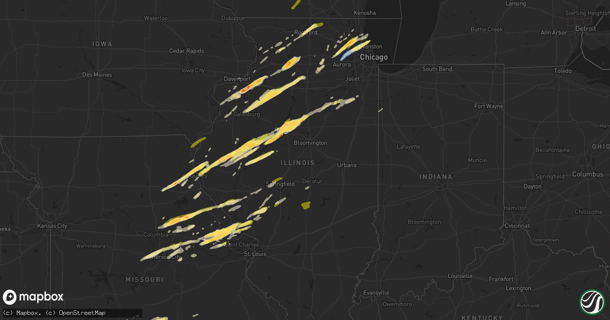
Hail Map in Illinois on April 20, 2023
Get this storm
April 20 map
$229
one time, instant access
Download today. No call, no setup
Keep the $229
Bought the map and want the full workflow? Apply the entire $229 to a subscription within 7 days. None of it is wasted.
Every map, not just this one
This buys you this map. Subscription and you get every map we run, in the markets you choose from a few cities to whole states to nationwide. Plus real-time alerts the moment a storm fires.
Contact data
Name, contact info, occupancy, even credit band for addresses in the footprint. You go from where it hit to who to call.
Become the source they trust
Unlimited branding weather history reports on demand. You already have the documented answer ready for the property owner, and you are the one who showed up with it.
Property data and RoofTrace estimates
Pull up any address you have got, its value and the exact code rules for that jurisdiction, straight from One Click Code. Then RoofTrace estimates the squares, pitch, and roof value, priced the way you price.
Storm reports in Illinois
Illinois
| Date | Description |
|---|---|
| 04/20/20236:59 PM CDT | Photo shared on social media of a roughly 5 inch diameter healthy tree limb snapped. Near 106th street and s cicero avenue. Time based on radar. |
| 04/20/20236:59 PM CDT | Dime sized hail near manteno. |
| 04/20/20236:51 PM CDT | Possible tree damage north of bonfield. Hail of unknown size covering the ground. |
| 04/20/20236:42 PM CDT | Relayed via mping. |
| 04/20/20236:40 PM CDT | Winds estimated up to 60mph east of south wilmington. |
| 04/20/20236:39 PM CDT | Relayed via |
| 04/20/20236:39 PM CDT | Relayed via mping. |
| 04/20/20236:36 PM CDT | Photo shared to social media shows hail about walnut sized. Time estimated by radar. |
| 04/20/20236:36 PM CDT | Possible damage to trees and power lines near baker road and us52 in manhattan. |
| 04/20/20236:26 PM CDT | Quarter sized hail near dwight. |
| 04/20/20236:21 PM CDT | Private weather station recorded 81 mph wind gust. |
| 04/20/20236:19 PM CDT | Time estimated by radar. |
| 04/20/20236:17 PM CDT | Report shared to social media of quarter sized hail near barrington. |
| 04/20/20236:15 PM CDT | Measured at pws kilvernon6. |
| 04/20/20236:10 PM CDT | Nws employee reports quarter sized hail in palatine. |
| 04/20/20236:10 PM CDT | Corrects time of previous tstm wnd gst report from 2 nnw mazon. Private weather station kilmazon10 recorded 59mph gust. |
| 04/20/20236:09 PM CDT | Relayed via mping. |
| 04/20/20236:07 PM CDT | Trained spotter reports quarter sized hail near quentin road and us12. |
| 04/20/20236:07 PM CDT | Quarter sized hail near rand road and lake cook road. |
| 04/20/20236:06 PM CDT | Delayed report of a large tree uprooted on a property near intersection of route 173 and clark road. Report relayed by print media. Time estimated by radar. |
| 04/20/20236:05 PM CDT | Updates previous report from dupage airport. Asos kdpa recorded 77 mph gust. |
| 04/20/20236:05 PM CDT | Hail up to half dollar sized in schaumburg. |
| 04/20/20236:05 PM CDT | Private weather station kilmazon10 recorded 59mph gust. |
| 04/20/20236:05 PM CDT | Asos kdpa recorded 60 mph gust. |
| 04/20/20236:04 PM CDT | Private weather station kilveron5 recorded 61mph gust. |
| 04/20/20236:04 PM CDT | Relayed via mping. |
| 04/20/20236:03 PM CDT | Relayed via mping. |
| 04/20/20235:57 PM CDT | Estimated 60mph gust near batavia. |
| 04/20/20235:55 PM CDT | Golf ball sized hail near hoffman estates. |
| 04/20/20235:52 PM CDT | Emergency manager reports 58 mph gust near woodstock. |
| 04/20/20235:50 PM CDT | Photo shared to social media shows quarter sized hail near elgin. Time estimated by radar. |
| 04/20/20235:48 PM CDT | Possible tree damage along harmony road west of us20. Relayed via social media. |
| 04/20/20235:43 PM CDT | A local report indicates 1.00 inch wind near 3 W NILWOOD |
| 04/20/20235:38 PM CDT | Powerlines down across gletty road. Time estimated based on radar. Relayed via dekalb county so. |
| 04/20/20235:35 PM CDT | 4-5 power poles leaning across the road at sr 23 and preserve road. Relayed via dekalb county so. |
| 04/20/20235:32 PM CDT | News report of powerlines down along pine street. Twitter report additionally indicated 99 percent of waterman customers had lost power. Time estimated based on radar. |
| 04/20/20235:15 PM CDT | A local report indicates 1.00 inch wind near SHERMAN |
| 04/20/20235:10 PM CDT | Quarter sized hail between loves park and rock cut state park. |
| 04/20/20235:07 PM CDT | A local report indicates 1.00 inch wind near 1 NW WASHINGTON |
| 04/20/20235:07 PM CDT | A local report indicates 1.75 inch wind near METAMORA |
| 04/20/20235:06 PM CDT | Relayed via mping. |
| 04/20/20235:06 PM CDT | Report relayed by em. |
| 04/20/20235:06 PM CDT | Report from mping: quarter |
| 04/20/20235:06 PM CDT | Large tree down in pekin - photo relayed by broadcast media on twitter. |
| 04/20/20235:06 PM CDT | Tree fell onto house. Public report and photo relayed through by broadcast media. Time estimated by radar. |
| 04/20/20235:03 PM CDT | A local report indicates 1.00 inch wind near 1 E METAMORA |
| 04/20/20234:59 PM CDT | A local report indicates 1.00 inch wind near FIELDON |
| 04/20/20234:59 PM CDT | Report from mping: quarter |
| 04/20/20234:58 PM CDT | Corrects previous hail report from manito. Location corrected. |
| 04/20/20234:58 PM CDT | A local report indicates 1.25 inch wind near MANITO |
| 04/20/20234:52 PM CDT | Delayed report. Social media photos show golf ball to hen egg size hail. |
| 04/20/20234:49 PM CDT | A local report indicates 1.75 inch wind near PEORIA HEIGHTS |
| 04/20/20234:48 PM CDT | A local report indicates 1.00 inch wind near 1 SE PRINCETON |
| 04/20/20234:45 PM CDT | Golf ball sized hail west of amboy. Time estimated by radar. |
| 04/20/20234:43 PM CDT | A local report indicates 1.75 inch wind near PEORIA |
| 04/20/20234:40 PM CDT | A local report indicates 1.00 inch wind near EAST PEORIA |
| 04/20/20234:30 PM CDT | A local report indicates 1.00 inch wind near 1 NW LEWISTOWN |
| 04/20/20234:30 PM CDT | Report from mping: 1-inch tree limbs broken; shingles blown off. |
| 04/20/20234:29 PM CDT | 4 inch diameter tree branch down. |
| 04/20/20234:23 PM CDT | Relayed via social media. |
| 04/20/20234:16 PM CDT | A local report indicates 1.00 inch wind near 1 S KEWANEE |
| 04/20/20234:15 PM CDT | A local report indicates 1.25 inch wind near POLO |
| 04/20/20234:13 PM CDT | A local report indicates 1.25 inch wind near KEWANEE |
| 04/20/20234:13 PM CDT | Relayed via social media. Time estimated by radar. |
| 04/20/20234:10 PM CDT | A local report indicates 1.00 inch wind near CANTON |
| 04/20/20234:05 PM CDT | Quarter size hail 1.5 miles southwest of galva. |
| 04/20/20234:03 PM CDT | Relayed via social media. Time estimated by radar. |
| 04/20/20234:00 PM CDT | Power poles reported down by public at this location. |
| 04/20/20233:58 PM CDT | Report from mping: half dollar |
| 04/20/20233:58 PM CDT | Report from mping: half dollar . |
| 04/20/20233:55 PM CDT | Quarter size hail in cuba. |
| 04/20/20233:45 PM CDT | A local report indicates 1.00 inch wind near GENESEO |
| 04/20/20233:40 PM CDT | Golf ball size hail west of smithfield. |
| 04/20/20233:37 PM CDT | Media relayed a viewer photo of golf ball size hail. |
| 04/20/20233:21 PM CDT | A local report indicates 2.00 inch wind near 1 SSW OSCO |
| 04/20/20233:20 PM CDT | Relayed via social media. |
| 04/20/20233:20 PM CDT | Relayed via social media. |
| 04/20/20233:20 PM CDT | Relayed by broadcast media. Viewer photo. |
| 04/20/20233:20 PM CDT | Spotter reported mostly quarters with a few stones up to 3.0 inches. Time of the event estimated using radar. |
| 04/20/20233:13 PM CDT | A local report indicates 1.00 inch wind near SHERRARD |
| 04/20/20233:12 PM CDT | Hail size increased to quarters. |
| 04/20/20233:10 PM CDT | Hail lasted 5 minutes and nearly covered the ground. |
| 04/20/20233:10 PM CDT | A local report indicates 1.00 inch wind near 1 WNW PLEASANT HILL |
| 04/20/20233:08 PM CDT | A local report indicates 1.00 inch wind near INDUSTRY |
| 04/20/20233:03 PM CDT | 4 inch diameter tree branches down at location. |
| 04/20/20233:00 PM CDT | Golf ball size hail at il 99 and il 101 intersection. |
| 04/20/20232:56 PM CDT | Corrects previous tstm wnd dmg report from 2 e malvern. A sporadic ef1 tornado begun just east of morrison il around 3:56 pm. The tornado damaged a power pole and a tre |
| 04/20/20232:00 PM CDT | A local report indicates 1.00 inch wind near 1 ENE QUINCY |
| 04/20/20232:00 PM CDT | A local report indicates 1.00 inch wind near 3 N QUINCY |
| 04/20/20231:55 PM CDT | A local report indicates 1.00 inch wind near 3 N QUINCY |
| 04/19/20237:37 PM CDT | A local report indicates 1.00 inch wind near PANA |
| 04/19/20237:34 PM CDT | Report from mping: quarter |
| 04/19/20237:04 PM CDT | Trees and wires down in the vicinity of 2434 w marquette. Time estimated based on radar. Relayed via chicago oemc. |
| 04/19/20237:04 PM CDT | Trees downed onto house near 8807 s bishop. Relayed via chicago oemc. Time estimated based on radar. |
| 04/19/20237:04 PM CDT | Trees and wires down in the vicinity of 2434 w marquette. Time estimated based on radar. Relayed via chicago oemc. This lsr is to correct the location of a previous rep |
All States Impacted by Hail Map on April 20, 2023
Cities Impacted by Hail Map on April 20, 2023
- Blanchard, OK
- Oklahoma City, OK
- Purcell, OK
- Washington, OK
- Elk Point, SD
- Mount Sterling, IL
- Versailles, IL
- Palmyra, MO
- Basco, IL
- New London, MO
- Hannibal, MO
- Hallsville, MO
- Centralia, MO
- Thompson, MO
- Mexico, MO
- Russellville, MO
- California, MO
- Rush Hill, MO
- Laddonia, MO
- Centertown, MO
- Jefferson City, MO
- Ewing, MO
- Philadelphia, MO
- Maywood, MO
- Durham, MO
- La Grange, MO
- Clayton, OK
- Springfield, MO
- Nashoba, OK
- Farber, MO
- Mullin, TX
- Zephyr, TX
- Comanche, TX
- Priddy, TX
- Vandalia, MO
- Quincy, IL
- Ursa, IL
- Fowler, IL
- Albion, OK
- Mendon, IL
- Paloma, IL
- Coatsburg, IL
- Curryville, MO
- Gustine, TX
- Loraine, IL
- Argyle, IA
- Wayland, MO
- Keokuk, IA
- Montrose, IA
- Trenton, TX
- Whitewright, TX
- Bonham, TX
- Randolph, TX
- Leonard, TX
- Rowlett, TX
- Honobia, OK
- Camp Point, IL
- Golden, IL
- Rockwall, TX
- Nauvoo, IL
- Niota, IL
- Ravenna, TX
- Ivanhoe, TX
- La Prairie, IL
- Bowen, IL
- Bowling Green, MO
- Cleburne, TX
- Grandview, TX
- Louisiana, MO
- Alvarado, TX
- Hartsburg, MO
- New Bloomfield, MO
- Porum, OK
- Fulton, MO
- Mokane, MO
- Steedman, MO
- Williamsburg, MO
- Hamilton, TX
- Pottsville, TX
- Augusta, IL
- Plymouth, IL
- Stigler, OK
- Vian, OK
- Webbers Falls, OK
- Wolfe City, TX
- Ladonia, TX
- Wellsville, MO
- Huntsville, IL
- Dodd City, TX
- Windom, TX
- Honey Grove, TX
- Whitesboro, OK
- Mesquite, TX
- Dallas, TX
- Balch Springs, TX
- Fordland, MO
- Seymour, MO
- Sunnyvale, TX
- Falcon, MO
- Evant, TX
- Jonesboro, TX
- Lynchburg, MO
- Mountain Grove, MO
- Plato, MO
- Roby, MO
- Sallisaw, OK
- Littleton, IL
- Industry, IL
- Colchester, IL
- Macomb, IL
- Muldrow, OK
- Roxton, TX
- Sherrard, IL
- Orion, IL
- Lynn Center, IL
- Forney, TX
- Green Forest, AR
- Pleasant Hill, IL
- Nebo, IL
- Pittsfield, IL
- Pearl, IL
- Osco, IL
- Coal Valley, IL
- Geneseo, IL
- Omaha, AR
- Itasca, TX
- Uniontown, AR
- Petty, TX
- Van Buren, AR
- Cedarville, AR
- Natural Dam, AR
- Warrenton, MO
- Hawk Point, MO
- Gatesville, TX
- Chester, AR
- Galesburg, IL
- Wataga, IL
- Oneida, IL
- Milford, TX
- Oglesby, TX
- Altona, IL
- San Saba, TX
- Adair, IL
- Table Grove, IL
- Marietta, IL
- Smithfield, IL
- Cuba, IL
- Vermont, IL
- Terrell, TX
- Crandall, TX
- Brookston, TX
- Paris, TX
- Ipava, IL
- Lewistown, IL
- Canton, IL
- Troy, MO
- Winfield, MO
- Foley, MO
- Moscow Mills, MO
- Prophetstown, IL
- Galva, IL
- Kewanee, IL
- Wright City, MO
- Neponset, IL
- Leander, TX
- Sheffield, IL
- Toulon, IL
- Lead Hill, AR
- Protem, MO
- Cedarcreek, MO
- Buda, IL
- Bethel, OK
- Commerce, TX
- Klondike, TX
- Pattonville, TX
- Deport, TX
- Uvalde, TX
- Brackettville, TX
- Yellville, AR
- Peel, AR
- Theodosia, MO
- Brodhead, WI
- Evansville, WI
- Tiskilwa, IL
- Wyanet, IL
- Princeton, IL
- Edgerton, WI
- Stoughton, WI
- Cambridge, WI
- Peoria, IL
- Mapleton, IL
- Bogata, TX
- Glasford, IL
- East Peoria, IL
- Peoria Heights, IL
- Berryville, AR
- Huntsville, AR
- Moody, TX
- McGregor, TX
- Alpena, AR
- Creve Coeur, IL
- Washington, IL
- Eddy, TX
- Bruceville, TX
- Lampasas, TX
- Lometa, TX
- Pontiac, MO
- Oakland, AR
- Isabella, MO
- Kaufman, TX
- Metamora, IL
- Dover, IL
- Malden, IL
- Kerrville, TX
- La Moille, IL
- Arlington, IL
- Comfort, TX
- Mendota, IL
- Eureka, IL
- Gainesville, MO
- Manito, IL
- Kingston Mines, IL
- Pekin, IL
- Jonesburg, MO
- Lowpoint, IL
- Old Monroe, MO
- Brussels, IL
- Batchtown, IL
- Roanoke, IL
- Benson, IL
- Washburn, IL
- Fredericksburg, TX
- Copperas Cove, TX
- Kempner, TX
- Fieldon, IL
- Hardin, IL
- Fort Hood, TX
- Browning, IL
- Chilton, TX
- Jerseyville, IL
- Kane, IL
- Medora, IL
- Astoria, IL
- Havana, IL
- Bath, IL
- Menard, TX
- Van Buren, MO
- Brady, TX
- Royse City, TX
- Rockford, IL
- Caddo Mills, TX
- Greenville, TX
- Melvin, TX
- Pleasant Plains, IL
- Springfield, IL
- Loves Park, IL
- Cantrall, IL
- Sherman, IL
- Caledonia, IL
- Machesney Park, IL
- Minonk, IL
- Poplar Grove, IL
- Dana, IL
- Capron, IL
- Varna, IL
- Elburn, IL
- Wasco, IL
- Saint Charles, IL
- Easton, IL
- Topeka, IL
- Forest City, IL
- South Elgin, IL
- Elgin, IL
- Bartlett, IL
- Eldorado, TX
- Dundee, IL
- Barrington, IL
- Hoffman Estates, IL
- Kemp, TX
- Silex, MO
- Biggsville, IL
- Rushville, IL
- Loami, IL
- Waverly, IL
- Auburn, IL
- Niangua, MO
- Marshfield, MO
- Leaf River, IL
- German Valley, IL
- Elkland, MO
- Dixon, IL
- Amboy, IL
- Harmon, IL
- Eldena, IL
- Franklin Grove, IL
- Liverpool, IL
- Eureka Springs, AR
- Phillipsburg, MO
- Conway, MO
- Marthasville, MO
- Elsberry, MO
- Carthage, IL
- Savanna, IL
- Thomson, IL
- Vanzant, MO
- Milan, IL
- Rudy, AR
- Salem, MO
- Montgomery City, MO
- Henderson, IL
- La Fayette, IL
- Arlington, TX
- Grand Prairie, TX
- Bushnell, IL
- Bellflower, MO
- Canton, MO
- Columbia, MO
- Auxvasse, MO
- Ellington, MO
- Viola, IL
- Winnebago, IL
- Byron, IL
- Branson, MO
- Modesto, IL
- Virden, IL
- Rhineland, MO
- Portland, MO
- Jacksonville, IL
- Murrayville, IL
- Winchester, IL
- Franklin, IL
- Forreston, IL
- Dora, MO
- Tecumseh, MO
- Caulfield, MO
- Harrison, AR
- Garfield, AR
- Morrison, IL
- Lanark, IL
- Polo, IL
- Milledgeville, IL
- Shannon, IL
- Seligman, MO
- Hartville, MO
- Rockbridge, IL
- Morocco, IN
- Hillsdale, IL
- Sterling, IL
- Piedmont, MO
- Ellsinore, MO
- Success, MO
- Grovespring, MO
- Bucyrus, MO
- Reynolds, IL
- Aledo, IL
- Smithville, OK
- Reeds Spring, MO
- Goldthwaite, TX
- Chadwick, IL
- Seagoville, TX
- Woodway, TX
- Rogers, AR
- Matherville, IL
- Atkinson, IL
- Keithsburg, IL
- New Windsor, IL
- Seaton, IL
- Joy, IL
- Winona, MO
- Martinsburg, MO
- New Florence, MO
- Watson, OK
- Broken Bow, OK
- Haworth, OK
- West Point, IL
- Shelbyville, MO
- Emden, MO
- Monroe City, MO
- Bettendorf, IA
- Davenport, IA
- Rock Island, IL
- Bend, TX
- Ava, MO
- Truxton, MO
- Foristell, MO
- Hindsville, AR
- Little York, IL
- Alexis, IL
- Monmouth, IL
- Oquawka, IL
- Cassville, MO
- Eagle Rock, MO
- Shell Knob, MO
- Tebbetts, MO
- Pecan Gap, TX
- Cooper, TX
- Ben Franklin, TX
- Lohman, MO
- Mulberry, AR
- Strafford, MO
- Republic, MO
- Brookline, MO
- Willow Springs, MO
- Ozark, MO
- Nixa, MO
- Rio, IL
- Richland Springs, TX
- Rogersville, MO
- Crawford, TX
- Hermann, MO
- Tarpley, TX
- Hugo, OK
- Medina, TX
- Bandera, TX
- Mena, AR
- Hatfield, AR
- Rattan, OK
- Mountainburg, AR
- Savoy, TX
- Deer Grove, IL
- Tampico, IL
- Quinlan, TX
- Garland, TX
- Fremont, MO
- Snow, OK
- Fort McKavett, TX
- Benton City, MO
- Cabool, MO
- Saint David, IL
- Camden, IL
- Bryant, IL
- Chamois, MO
- Holts Summit, MO
- Bonnots Mill, MO
- Purmela, TX
- Hillview, IL
- Shelbina, MO
- Valley Mills, TX
- White Hall, IL
- Kampsville, IL
- Alpha, IL
- Ophiem, IL
- Timewell, IL
- Clarence, MO
- Clayton, IL
- Lentner, MO
- Trivoli, IL
- Daisy, OK
- Latham, MO
- High Hill, MO
- Barnett, MO
- Wentzville, MO
- Taylor, MO
- O'Fallon, MO
- Lake Saint Louis, MO
- Sabinal, TX
- Grafton, IL
- Dow, IL
- Willow City, TX
- Lake Zurich, IL
- Palatine, IL
- Mabank, TX
- Dike, TX
- Burnet, TX
- Sulphur Bluff, TX
- Canton, TX
- Mount Vernon, TX
- Talco, TX
- Rio Medina, TX
- San Antonio, TX
- Mico, TX
- Franklin, WI
- Greendale, WI
- Milwaukee, WI
- Mount Pleasant, TX
- Schaumburg, IL
- Streamwood, IL
- Arlington Heights, IL
- Buffalo Grove, IL
- Wheeling, IL
- Mooseheart, IL
- North Aurora, IL
- Batavia, IL
- Geneva, IL
- West Chicago, IL
- Warrenville, IL
- Wayne, IL
- Carol Stream, IL
- Roselle, IL
- Hanover Park, IL
- Bloomingdale, IL
- Northbrook, IL
- Glenview, IL
- Liberty Hill, TX
- Georgetown, TX
- Winnetka, IL
- Glencoe, IL
- Elk Grove Village, IL
- Medinah, IL
- Rolling Meadows, IL
- Mount Prospect, IL
- Glendale Heights, IL
- Winfield, IL
- Itasca, IL
- Prospect Heights, IL
- Des Plaines, IL
- Tyler, TX
- Verona, IL
- Morris, IL
- Mazon, IL
- Minooka, IL
- Wilmington, IL
- Channahon, IL
- Elwood, IL
- Dwight, IL
- Gardner, IL
- South Wilmington, IL
- Reddick, IL
- Essex, IL
- Bonfield, IL
- Kankakee, IL
- Manteno, IL
- Bourbonnais, IL
- Owaneco, IL
- Pana, IL
- Assumption, IL
- Caldwell, TX
- Hearne, TX
- Texarkana, TX
- Hooks, TX
- Nash, TX
- Harper, TX
- Jbsa Ft Sam Houston, TX
- Jbsa Lackland, TX
- Winona, TX
- Ozark, AR
- Cecil, AR
- Mountain Home, TX
- Bastrop, TX
- Paige, TX
- Smithville, TX
- West Point, TX
- Euless, TX
- Fort Worth, TX
- Iredell, TX
- Walnut Springs, TX
- Irving, TX
- Morgan, TX
- Kopperl, TX
- Carrollton, TX
- Addison, TX
- Rocksprings, TX
- Leakey, TX
- Hunt, TX
- Plano, TX
- La Grange, TX
- Talihina, OK
- Muse, OK
- Hodgen, OK
- Heavener, OK
- Allen, TX
- Rio Vista, TX
- Glen Rose, TX
- Libertyville, IL
- Lake Forest, IL
- Hampshire, IL
- Caledonia, WI
- Oak Creek, WI
- Sycamore, IL
- Genoa, IL
- Van Alstyne, TX
- Baileyville, IL
- Crystal Lake, IL
- Lake In The Hills, IL
- Cary, IL
- Horseshoe Bay, TX
- Llano, TX
- Mount Morris, IL
- Fox River Grove, IL
- Carpentersville, IL
- Algonquin, IL
- Gilberts, IL
- Huntley, IL
- New Berlin, IL
- Paron, AR
- Lonsdale, AR
- Hot Springs Village, AR
- Mundelein, IL
- Grayslake, IL
- Round Lake, IL
- Fort Smith, AR
- Charleston, AR
- Kilbourne, IL
- Beardstown, IL
- Granger, TX
- Hillsboro, TX
- Green Valley, IL
- Elgin, TX
- Dekalb, IL
- Hinckley, IL
- Waterman, IL
- Palmyra, IL
- Hettick, IL
- Killeen, TX
- Rosebud, TX
- Burlington, TX
- Blue Mound, IL
- Macon, IL
- Hales Corners, WI
- Saint Francis, WI
- Muskego, WI
- Ben Wheeler, TX
- Mill Spring, MO
- Little Rock, AR
- Sandwich, IL
- Earlville, IL
- Leland, IL
- Somonauk, IL
- Linn, MO
- Richards, TX
- Bedias, TX
- Huntsville, TX
- Frederick, IL
- Jarrell, TX
- Holland, TX
- Austin, TX
- Cedar Park, TX
- Florence, TX
- Troy, TX
- Lott, TX
- Temple, TX
- Carlinville, IL
- Carrollton, IL
- Chesterfield, IL
- Greenfield, IL
- Maud, TX
- Murchison, TX
- Rock Falls, IL
- Anna, TX
- Highland Park, IL
- D Hanis, TX
- Wilmette, IL
- Niles, IL
- Wood Dale, IL
- Mineral, IL
- Haltom City, TX
- Pipe Creek, TX
- Park Ridge, IL
- Bensenville, IL
- Bartlett, TX
- Greenwood, AR
- Huntington, AR
- Wister, OK
- Bells, TX
- Voca, TX
- Johnson City, TX
- Telephone, TX
- Ashton, IL
- Deerfield, IL
- Waco, TX
- Bertram, TX
- Stonewall, TX
- Ohio, IL
- Sublette, IL
- Gause, TX
- Milano, TX
- Jessieville, AR
- Belton, TX
- Buckholts, TX
- Davilla, TX
- Rockdale, TX
- Cameron, TX
- Lorena, TX
- Manor, TX
- Pflugerville, TX
- Round Mountain, TX
- Malta, IL
- Tom Bean, TX
- Taylor, TX
- Girard, IL
- College Station, TX
- Bryan, TX
- Blue Ridge, TX
- Ector, TX
- Scurry, TX
- Wills Point, TX
- Marble Falls, TX
- Kingsland, TX
- Junction, TX
- Doss, TX
- Somerville, TX
- Helotes, TX
- Kinsman, IL
- Colleyville, TX
- Lewisville, TX
- Hurst, TX
- Coppell, TX
- Bedford, TX
- North Richland Hills, TX
- Grapevine, TX
- Center Point, TX
- Utopia, TX
- Blackstone, IL
- Cornell, IL
- Hanna City, IL
- Rogers, TX
- Thorndale, TX
- Abbott, TX
- Hondo, TX
- Lincolnshire, IL
- Vernon Hills, IL
- Salado, TX
- Spicewood, TX
- Farmersville, IL
- Divernon, IL
- Pawnee, IL
- Boswell, OK
- Gipsy, MO
- Zalma, MO
- Golden Eagle, IL
- Morton, IL
- Maple Park, IL
- Highwood, IL
- New Boston, TX
- Marlin, TX
- Alexander, IL
- Franklin, TX
- Aquilla, TX
- Lowndes, MO
- Wappapello, MO
- Buchanan Dam, TX
- Ransom, IL
- Streator, IL
- Bennington, OK
- Rutland, IL
- Long Point, IL
- Ancona, IL
- Pontiac, IL
- Elmendorf, TX
- McGee, MO
- Lake Creek, TX
- Anderson, TX
- Harker Heights, TX
- Nolanville, TX
- Reagan, TX
- Briggs, TX
- Mckinney, TX
- Kendalia, TX
- Boerne, TX
- Spring Branch, TX
- Canyon Lake, TX
- New Braunfels, TX
- Farmersville, TX
- Fischer, TX
- Blanco, TX
- Vanderpool, TX
- Wimberley, TX
- San Marcos, TX
- Seguin, TX
- McQueeney, TX
- Kingsbury, TX
- Luling, TX
- Gonzales, TX
- Lytle, TX
- Somerset, TX
- Poteet, TX
- Von Ormy, TX
- Galveston, TX
- Floresville, TX
- Pleasanton, TX
- Yoakum, TX
- Shiner, TX
- Hallettsville, TX
- Runge, TX
- Karnes City, TX
- Nordheim, TX
- Goliad, TX
- Burleson, TX
- Liberty, TX
- Conroe, TX
- New Caney, TX
- Natalia, TX
- Frisco, TX
- Giddings, TX
- Prosper, TX
- McDade, TX
- Wylie, TX
- Richardson, TX
- Mertens, TX
- Nixon, TX
- Muldoon, TX
- Celeste, TX
- The Colony, TX
- Sachse, TX
- Ingram, TX
- Rosanky, TX
- Red Rock, TX
- Princeton, TX
- Kingwood, TX
- Harwood, TX
- Humble, TX
- Tomball, TX
- Spring, TX
- Houston, TX
- Joshua, TX
- Sonora, TX
- Cost, TX
- Leesville, TX
- Atascosa, TX
- La Coste, TX
- Castroville, TX
- Martindale, TX
- Rosharon, TX
- Manvel, TX
- Meridian, TX
- Hico, TX
- Devine, TX
- Yorktown, TX
- Taylor Ridge, IL
- Ganado, TX
- Falls City, TX
- Tivoli, TX
- Sweeny, TX
- Victoria, TX
- Needville, TX
- Porter, TX
- Huffman, TX
- Hobson, TX
- Hull, TX
- Palacios, TX
- Adkins, TX
- Smiley, TX
- Wrightsboro, TX
- Kenedy, TX
- La Vernia, TX
- Poth, TX
- Dayton, TX
- Crosby, TX
- Gerlaw, IL
- Cuero, TX


