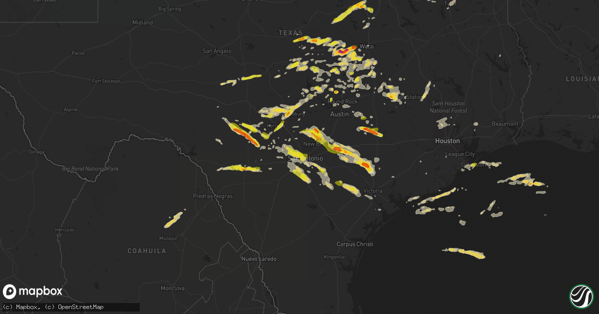
Hail Map on April 20, 2023
Get this storm
April 20 map
$229
one time, instant access
Download today. No call, no setup
Keep the $229
Bought the map and want the full workflow? Apply the entire $229 to a subscription within 7 days. None of it is wasted.
Every map, not just this one
This buys you this map. Subscription and you get every map we run, in the markets you choose from a few cities to whole states to nationwide. Plus real-time alerts the moment a storm fires.
Contact data
Name, contact info, occupancy, even credit band for addresses in the footprint. You go from where it hit to who to call.
Become the source they trust
Unlimited branding weather history reports on demand. You already have the documented answer ready for the property owner, and you are the one who showed up with it.
Property data and RoofTrace estimates
Pull up any address you have got, its value and the exact code rules for that jurisdiction, straight from One Click Code. Then RoofTrace estimates the squares, pitch, and roof value, priced the way you price.
States Impacted by Hail Map on April 20, 2023
Storm reports
Iowa
| Date | Description |
|---|---|
| 04/20/20232:19 PM CDT | Barn destroyed on 223rd ave and 300th st |
Texas
| Date | Description |
|---|---|
| 04/20/20236:55 PM CDT | Facebook report of estimated quarter size hail with a few a bit larger. |
| 04/20/20236:54 PM CDT | Report from mping quarter |
| 04/20/20236:51 PM CDT | Quarter size hail in leon valley. |
| 04/20/20236:46 PM CDT | Delayed report. Pole uprooted and upside down; sheet metal in tree; trailer on its side. Location approximately 1 mile west of cr 348 loop on hwy 79. Time estimated by |
| 04/20/20236:43 PM CDT | Report from mping quarter |
| 04/20/20236:43 PM CDT | Tree down near sea world. |
| 04/20/20236:40 PM CDT | Report from mping: quarter |
| 04/20/20236:40 PM CDT | Trees down in the shiro area. Includes highway 30... Cr 234 & cr 229. |
| 04/20/20236:35 PM CDT | Sporadic tree limbs snapped and roof damage in the alamo ranch area. Time estimated from radar. |
| 04/20/20236:19 PM CDT | Quarter size hail in burnet. |
| 04/20/20236:19 PM CDT | Report from mping quarter |
| 04/20/20236:10 PM CDT | Trees down across the road. |
| 04/20/20235:51 PM CDT | Quarter size hail east of willow city. |
| 04/20/20235:47 PM CDT | Half dollar size hail near fredericksburg. |
| 04/20/20235:38 PM CDT | Report from mping quarter |
| 04/20/20235:33 PM CDT | Report from mping ping pong ball |
| 04/20/20235:29 PM CDT | Social media picture of estimated golf ball sized hail. Time and location estimated by radar. |
| 04/20/20235:25 PM CDT | Report from mping: ping pong ball |
| 04/20/20235:23 PM CDT | Report from mping: half dollar |
| 04/20/20235:21 PM CDT | Report from mping: half dollar |
| 04/20/20235:16 PM CDT | Ping pong ball size hail in uvalde. |
| 04/20/20235:05 PM CDT | A local report indicates 1.00 inch wind near MENARD |
| 04/20/20235:05 PM CDT | Broadcast media relays social media report of 1 inch hail in bruceville-eddy. Time estimated by radar. |
| 04/20/20234:50 PM CDT | Broadcast media relays social media report of golf ball size hail due south of the bucees in terrell. Time estimated by radar. |
| 04/20/20234:49 PM CDT | Quarter size hail in kerrville. |
| 04/20/20234:40 PM CDT | Report from mping: quarter |
| 04/20/20234:33 PM CDT | Report from mping: golf ball |
| 04/20/20234:30 PM CDT | Trained spotter reports 1 inch hail... With some larger stones on the south side of mcgregor. Time and location estimated by radar. |
| 04/20/20234:25 PM CDT | Delayed report. Social media picture of large hailstone measuring around 3.5 inches. Time estimated by radar. |
| 04/20/20234:25 PM CDT | Social media picture of 2 to 2.5 inch hail in crandall. Time estimated by radar. |
| 04/20/20234:23 PM CDT | A local report indicates 1.75 inch wind near 2 SSE CRAWFORD |
| 04/20/20234:17 PM CDT | Broadcast media reports golf ball size hail at fm 1641 and helms trail in talty. Covering ground. Time estimated by radar. |
| 04/20/20234:14 PM CDT | A local report indicates 2.00 inch wind near 4 NNW OGLESBY |
| 04/20/20234:01 PM CDT | Report from mping quarter |
| 04/20/20234:00 PM CDT | Ham relays trained spotter report of ping pong hail on i-20 and fm 741 near forney/heartland. |
| 04/20/20233:59 PM CDT | Report from mping: half dollar |
| 04/20/20233:53 PM CDT | A local report indicates 2.00 inch wind near 2 ENE SOUTH MOUNTAIN |
| 04/20/20233:44 PM CDT | A local report indicates 2.00 inch wind near GATESVILLE |
| 04/20/20233:43 PM CDT | Broadcast media relays report of ping pong size hail... Just shy of golf ball size near a middle school in forney. Time estimated by radar. |
| 04/20/20232:56 PM CDT | Social media picture report of 1.5 inch hail near ralph hall parkway and sh 205 in rockwall. |
| 04/20/20232:54 PM CDT | Report from mping: ping pong ball |
| 04/20/20232:50 PM CDT | Em reports 1 inch hail at rockwall county sheriffs office. Time estimated by radar. |
| 04/20/20232:45 PM CDT | Em reports 1 inch hail near highway 4 and cr 305 near grandview. Time estimated by radar. |
| 04/20/20232:38 PM CDT | Report from mping: ping pong ball |
| 04/20/20232:28 PM CDT | Social media report of 1 inch hail 5 miles west of pottsville... Texas. |
| 04/20/20232:25 PM CDT | 1 hail in rowlett... At rowlett road and hickox. |
| 04/20/20232:20 PM CDT | Em relayed that rowlett fire reporting quarter size hail at miller and chiesa in rowlett at 2:20 pm. |
| 04/20/20232:20 PM CDT | Quarter sized hail at highway 78 & fm 1150 north of bonham. |
| 04/20/20232:17 PM CDT | Report of 1 inch measured hail 6 miles north of leonard near highway 11 and fm 1553. Time estimated by radar. |
| 04/20/202310:39 AM CDT | A local report indicates 1.00 inch wind near 1 S ALVARADO |
| 04/20/20234:35 AM CDT | Two sizeable trees down blocking the entire roadway in the 15000 block of almeda school rd. |
| 04/20/20231:55 AM CDT | Hail reported varying from quarter to golfball sized. |
| 04/20/202312:55 AM CDT | Quarter sized hail was observed near the intersection of 20th street and market street. |
| 04/20/202312:33 AM CDT | Nickel to quarter size hail reported at this time via twitter in nw san antonio. |
| 04/19/202311:40 PM CDT | Roof taken off small barn. Time estimated from radar. |
| 04/19/202311:13 PM CDT | Public estimated ping pong ball size hail just south of canyon lake off fm 2673. |
| 04/19/202311:09 PM CDT | Coop observer reports quarter size hail with numerous pea to dime size hail stones as well. |
| 04/19/202311:05 PM CDT | Via twitter photo of several ping pong to golf ball size hail. Time estimated via radar imagery. |
| 04/19/202311:01 PM CDT | Mping report of half dollar size hail. |
| 04/19/202310:45 PM CDT | Report from mping: ping pong ball |
| 04/19/202310:42 PM CDT | Report from mping: ping pong ball |
| 04/19/202310:41 PM CDT | Report from mping: half dollar |
| 04/19/202310:40 PM CDT | A nws storm survey team determined that a tornado touched down just west of the lakeside golf club north of fm 2673. The tornado tracked southeast approximately three m |
| 04/19/202310:40 PM CDT | A local report indicates 2.00 inch wind near 1 SE ALLEN |
| 04/19/202310:39 PM CDT | Corrects time of previous hail report from 1 s alvarado. |
| 04/19/202310:38 PM CDT | Report from mping: golf ball |
| 04/19/202310:38 PM CDT | Deck roof on second story of home was peeled off. Time estimated off radar. Additional sporadic straight-line wind damage was observed around canyon lake. |
| 04/19/202310:30 PM CDT | A local report indicates 1.75 inch wind near 5 SSE KEENE |
| 04/19/202310:30 PM CDT | Report from mping: tea cup |
| 04/19/202310:20 PM CDT | Quarter sized hail at i-35 and belt line rd in carrollton. |
| 04/19/20239:57 PM CDT | A local report indicates 1.00 inch wind near 1 SSW EULESS |
| 04/19/20239:56 PM CDT | Report from mping: quarter |
| 04/19/20239:29 PM CDT | Via facebook with photo of golf ball size hail. |
| 04/19/20238:41 PM CDT | Ping pong ball sized hail was observed along cr 216 in cooks point. |
| 04/19/20238:41 PM CDT | Large trees were downed on cr 216 in cooks point. |
| 04/19/20238:18 PM CDT | Emergency manager... Public and media reports of a few trees down and about 5 homes with minor roof damage in the college station area. |
| 04/19/20237:56 PM CDT | Report from mping. |
| 04/19/20237:41 PM CDT | Corrects time previous hail report from 7 ne caldwell. Ping pong ball sized hail was observed along cr 216 in cooks point. |
| 04/19/20237:41 PM CDT | Corrects time previous tstm wnd dmg report from 7 ne caldwell. Large trees were downed on cr 216 in cooks point. |
| 04/19/20237:41 PM CDT | Ping pong ball sized hail was observed along cr 216 in cooks point. |
| 04/19/20237:41 PM CDT | Large trees were downed on cr 216 in cooks point. |
| 04/19/20237:40 PM CDT | Trees and power lines down. |
| 04/19/20237:40 PM CDT | Quarter size hail at trinity university. |
| 04/19/20237:39 PM CDT | Report from mping: quarter |
| 04/19/20237:34 PM CDT | Picture of quarter size hail relayed via facebook. |
| 04/19/20237:26 PM CDT | Quarter |
| 04/19/20237:21 PM CDT | Report from mping 1-inch tree limbs broken. |
| 04/19/20237:10 PM CDT | Damage reported at tyler junior college with funnel observed. |
| 04/19/20237:06 PM CDT | Report from mping quarter |
| 04/19/20237:05 PM CDT | An ef-0 tornado with maximum estimated winds near 80 mph touched down in the midtown area of tyler... Near lloyd james funeral home at the intersection of east 1st stre |
| 04/19/20237:03 PM CDT | Report from mping ping pong ball |
| 04/19/20237:00 PM CDT | Gas station employee in talco heard public reports of brief hail up to golf ball size in and around talco. |
| 04/19/20237:00 PM CDT | Facebook report of estimated quarter size hail. |
Missouri
| Date | Description |
|---|---|
| 04/20/20235:47 PM CDT | Pea sized hail fell for a period of 8 minutes with a brief period of hail around the size of quarters. Observation was taken off of wilmer valley drive. |
| 04/20/20235:07 PM CDT | Two separate reports of dime to quarter size hail in van buren. Report relayed by emergency management. |
| 04/20/20234:31 PM CDT | Report from mping: quarter |
| 04/20/20234:30 PM CDT | A local report indicates 1.75 inch wind near 2 S PROTEM |
| 04/20/20234:28 PM CDT | A local report indicates 1.50 inch wind near 2 WNW MOSCOW MILLS |
| 04/20/20234:26 PM CDT | Report from mping: ping pong ball |
| 04/20/20234:24 PM CDT | Viewer picture of slightly bigger than quarter size hail in wright city. Time based on radar. |
| 04/20/20234:17 PM CDT | A local report indicates 1.75 inch wind near 3 NNE WARRENTON |
| 04/20/20234:15 PM CDT | Damage: broken window and damaged deck. |
| 04/20/20234:05 PM CDT | A local report indicates 1.00 inch wind near 3 WNW WINFIELD |
| 04/20/20234:04 PM CDT | A local report indicates 1.75 inch wind near 1 NE TROY |
| 04/20/20234:02 PM CDT | Report from mping: quarter |
| 04/20/20233:58 PM CDT | Report from mping: quarter |
| 04/20/20233:57 PM CDT | Report from mping: quarter |
| 04/20/20233:56 PM CDT | A local report indicates 1.25 inch wind near TROY |
| 04/20/20233:56 PM CDT | A local report indicates 1.75 inch wind near 1 E TROY |
| 04/20/20233:56 PM CDT | Report from mping: half dollar |
| 04/20/20233:55 PM CDT | A local report indicates 1.50 inch wind near TROY |
| 04/20/20233:55 PM CDT | A local report indicates 1.00 inch wind near TROY |
| 04/20/20233:54 PM CDT | A local report indicates 1.00 inch wind near 1 NNW TROY |
| 04/20/20233:53 PM CDT | A local report indicates 60 MPH wind near TROY |
| 04/20/20233:49 PM CDT | A local report indicates 1.00 inch wind near 3 SSW CAVE |
| 04/20/20233:09 PM CDT | A local report indicates 1.00 inch wind near PLATO |
| 04/20/20232:47 PM CDT | A local report indicates 1.00 inch wind near WELLSVILLE |
| 04/20/20232:44 PM CDT | Nickel to quarter size hail in fordland. |
| 04/20/20232:44 PM CDT | Nickel to quarter size hail in fordland. |
| 04/20/20232:17 PM CDT | A local report indicates 1.00 inch wind near 5 SE CARRINGTON |
| 04/20/20232:14 PM CDT | Via social media. Time estimated using radar. |
| 04/20/20232:08 PM CDT | Reported at shell oil. Nickle to quarter size reported. |
| 04/20/20232:05 PM CDT | A local report indicates 1.00 inch wind near FARBER |
| 04/20/20232:05 PM CDT | A local report indicates 1.25 inch wind near 1 N FARBER |
| 04/20/20232:05 PM CDT | A local report indicates 1.00 inch wind near LADDONIA |
| 04/20/20232:04 PM CDT | A local report indicates 1.25 inch wind near LADDONIA |
| 04/20/20232:00 PM CDT | A local report indicates 1.50 inch wind near LA GRANGE |
| 04/20/20231:59 PM CDT | Report from mping: quarter |
| 04/20/20231:58 PM CDT | A local report indicates 1.75 inch wind near LADDONIA |
| 04/20/20231:56 PM CDT | A local report indicates 1.00 inch wind near LA GRANGE |
| 04/20/20231:48 PM CDT | Electric poles snapped and down with pea size hail. |
| 04/20/20231:45 PM CDT | A local report indicates 1.75 inch wind near 1 WNW MEXICO |
| 04/20/20231:42 PM CDT | 8-12 inch diameter tree limbs blown down. |
| 04/20/20231:42 PM CDT | A local report indicates 1.75 inch wind near 1 NNW MEXICO |
| 04/20/20231:42 PM CDT | A local report indicates 1.50 inch wind near 1 NW MEXICO |
| 04/20/20231:42 PM CDT | A local report indicates 1.50 inch wind near MEXICO |
| 04/20/20231:40 PM CDT | Report from mping: quarter |
| 04/20/20231:40 PM CDT | A local report indicates 1.75 inch wind near 2 WSW MEXICO |
| 04/20/20231:40 PM CDT | A local report indicates 1.00 inch wind near 1 W MEXICO |
| 04/20/20231:29 PM CDT | A local report indicates 1.75 inch wind near 2 N EMDEN |
| 04/20/20231:14 PM CDT | Asos station ksgf springfield asos. |
Michigan
| Date | Description |
|---|---|
| 04/19/20237:34 PM CDT | Asos station kmkg muskegon county airport. |
Arkansas
| Date | Description |
|---|---|
| 04/20/20236:20 PM CDT | A few trees were blown down. |
| 04/20/20235:30 PM CDT | A few trees were blown down. |
| 04/20/20234:30 PM CDT | Golfball sized hail also observed on video from a broadcast media tower cam on bull shoals lake. |
| 04/20/20233:45 PM CDT | Reported on highway 65 south of omaha. |
| 04/20/20233:28 PM CDT | A local report indicates 1.00 inch wind near BLUE EYE |
| 04/20/20233:22 PM CDT | A local report indicates 1.00 inch wind near GREEN FOREST |
| 04/19/20238:28 PM CDT | Most stones were dime to nickel. |
Illinois
| Date | Description |
|---|---|
| 04/20/20236:59 PM CDT | Dime sized hail near manteno. |
| 04/20/20236:59 PM CDT | Photo shared on social media of a roughly 5 inch diameter healthy tree limb snapped. Near 106th street and s cicero avenue. Time based on radar. |
| 04/20/20236:51 PM CDT | Possible tree damage north of bonfield. Hail of unknown size covering the ground. |
| 04/20/20236:42 PM CDT | Relayed via mping. |
| 04/20/20236:40 PM CDT | Winds estimated up to 60mph east of south wilmington. |
| 04/20/20236:39 PM CDT | Relayed via |
| 04/20/20236:39 PM CDT | Relayed via mping. |
| 04/20/20236:36 PM CDT | Photo shared to social media shows hail about walnut sized. Time estimated by radar. |
| 04/20/20236:36 PM CDT | Possible damage to trees and power lines near baker road and us52 in manhattan. |
| 04/20/20236:26 PM CDT | Quarter sized hail near dwight. |
| 04/20/20236:21 PM CDT | Private weather station recorded 81 mph wind gust. |
| 04/20/20236:19 PM CDT | Time estimated by radar. |
| 04/20/20236:17 PM CDT | Report shared to social media of quarter sized hail near barrington. |
| 04/20/20236:15 PM CDT | Measured at pws kilvernon6. |
| 04/20/20236:10 PM CDT | Corrects time of previous tstm wnd gst report from 2 nnw mazon. Private weather station kilmazon10 recorded 59mph gust. |
| 04/20/20236:10 PM CDT | Nws employee reports quarter sized hail in palatine. |
| 04/20/20236:09 PM CDT | Relayed via mping. |
| 04/20/20236:07 PM CDT | Trained spotter reports quarter sized hail near quentin road and us12. |
| 04/20/20236:07 PM CDT | Quarter sized hail near rand road and lake cook road. |
| 04/20/20236:06 PM CDT | Delayed report of a large tree uprooted on a property near intersection of route 173 and clark road. Report relayed by print media. Time estimated by radar. |
| 04/20/20236:05 PM CDT | Asos kdpa recorded 60 mph gust. |
| 04/20/20236:05 PM CDT | Private weather station kilmazon10 recorded 59mph gust. |
| 04/20/20236:05 PM CDT | Updates previous report from dupage airport. Asos kdpa recorded 77 mph gust. |
| 04/20/20236:05 PM CDT | Hail up to half dollar sized in schaumburg. |
| 04/20/20236:04 PM CDT | Relayed via mping. |
| 04/20/20236:04 PM CDT | Private weather station kilveron5 recorded 61mph gust. |
| 04/20/20236:03 PM CDT | Relayed via mping. |
| 04/20/20235:57 PM CDT | Estimated 60mph gust near batavia. |
| 04/20/20235:55 PM CDT | Golf ball sized hail near hoffman estates. |
| 04/20/20235:52 PM CDT | Emergency manager reports 58 mph gust near woodstock. |
| 04/20/20235:50 PM CDT | Photo shared to social media shows quarter sized hail near elgin. Time estimated by radar. |
| 04/20/20235:48 PM CDT | Possible tree damage along harmony road west of us20. Relayed via social media. |
| 04/20/20235:43 PM CDT | A local report indicates 1.00 inch wind near 3 W NILWOOD |
| 04/20/20235:38 PM CDT | Powerlines down across gletty road. Time estimated based on radar. Relayed via dekalb county so. |
| 04/20/20235:35 PM CDT | 4-5 power poles leaning across the road at sr 23 and preserve road. Relayed via dekalb county so. |
| 04/20/20235:32 PM CDT | News report of powerlines down along pine street. Twitter report additionally indicated 99 percent of waterman customers had lost power. Time estimated based on radar. |
| 04/20/20235:15 PM CDT | A local report indicates 1.00 inch wind near SHERMAN |
| 04/20/20235:10 PM CDT | Quarter sized hail between loves park and rock cut state park. |
| 04/20/20235:07 PM CDT | A local report indicates 1.00 inch wind near 1 NW WASHINGTON |
| 04/20/20235:07 PM CDT | A local report indicates 1.75 inch wind near METAMORA |
| 04/20/20235:06 PM CDT | Relayed via mping. |
| 04/20/20235:06 PM CDT | Report from mping: quarter |
| 04/20/20235:06 PM CDT | Large tree down in pekin - photo relayed by broadcast media on twitter. |
| 04/20/20235:06 PM CDT | Report relayed by em. |
| 04/20/20235:06 PM CDT | Tree fell onto house. Public report and photo relayed through by broadcast media. Time estimated by radar. |
| 04/20/20235:03 PM CDT | A local report indicates 1.00 inch wind near 1 E METAMORA |
| 04/20/20234:59 PM CDT | Report from mping: quarter |
| 04/20/20234:59 PM CDT | A local report indicates 1.00 inch wind near FIELDON |
| 04/20/20234:58 PM CDT | Corrects previous hail report from manito. Location corrected. |
| 04/20/20234:58 PM CDT | A local report indicates 1.25 inch wind near MANITO |
| 04/20/20234:52 PM CDT | Delayed report. Social media photos show golf ball to hen egg size hail. |
| 04/20/20234:49 PM CDT | A local report indicates 1.75 inch wind near PEORIA HEIGHTS |
| 04/20/20234:48 PM CDT | A local report indicates 1.00 inch wind near 1 SE PRINCETON |
| 04/20/20234:45 PM CDT | Golf ball sized hail west of amboy. Time estimated by radar. |
| 04/20/20234:43 PM CDT | A local report indicates 1.75 inch wind near PEORIA |
| 04/20/20234:40 PM CDT | A local report indicates 1.00 inch wind near EAST PEORIA |
| 04/20/20234:30 PM CDT | A local report indicates 1.00 inch wind near 1 NW LEWISTOWN |
| 04/20/20234:30 PM CDT | Report from mping: 1-inch tree limbs broken; shingles blown off. |
| 04/20/20234:29 PM CDT | 4 inch diameter tree branch down. |
| 04/20/20234:23 PM CDT | Relayed via social media. |
| 04/20/20234:16 PM CDT | A local report indicates 1.00 inch wind near 1 S KEWANEE |
| 04/20/20234:15 PM CDT | A local report indicates 1.25 inch wind near POLO |
| 04/20/20234:13 PM CDT | A local report indicates 1.25 inch wind near KEWANEE |
| 04/20/20234:13 PM CDT | Relayed via social media. Time estimated by radar. |
| 04/20/20234:10 PM CDT | A local report indicates 1.00 inch wind near CANTON |
| 04/20/20234:05 PM CDT | Quarter size hail 1.5 miles southwest of galva. |
| 04/20/20234:03 PM CDT | Relayed via social media. Time estimated by radar. |
| 04/20/20234:00 PM CDT | Power poles reported down by public at this location. |
| 04/20/20233:58 PM CDT | Report from mping: half dollar . |
| 04/20/20233:58 PM CDT | Report from mping: half dollar |
| 04/20/20233:55 PM CDT | Quarter size hail in cuba. |
| 04/20/20233:45 PM CDT | A local report indicates 1.00 inch wind near GENESEO |
| 04/20/20233:40 PM CDT | Golf ball size hail west of smithfield. |
| 04/20/20233:37 PM CDT | Media relayed a viewer photo of golf ball size hail. |
| 04/20/20233:21 PM CDT | A local report indicates 2.00 inch wind near 1 SSW OSCO |
| 04/20/20233:20 PM CDT | Relayed by broadcast media. Viewer photo. |
| 04/20/20233:20 PM CDT | Relayed via social media. |
| 04/20/20233:20 PM CDT | Relayed via social media. |
| 04/20/20233:20 PM CDT | Spotter reported mostly quarters with a few stones up to 3.0 inches. Time of the event estimated using radar. |
| 04/20/20233:13 PM CDT | A local report indicates 1.00 inch wind near SHERRARD |
| 04/20/20233:12 PM CDT | Hail size increased to quarters. |
| 04/20/20233:10 PM CDT | A local report indicates 1.00 inch wind near 1 WNW PLEASANT HILL |
| 04/20/20233:10 PM CDT | Hail lasted 5 minutes and nearly covered the ground. |
| 04/20/20233:08 PM CDT | A local report indicates 1.00 inch wind near INDUSTRY |
| 04/20/20233:03 PM CDT | 4 inch diameter tree branches down at location. |
| 04/20/20233:00 PM CDT | Golf ball size hail at il 99 and il 101 intersection. |
| 04/20/20232:56 PM CDT | Corrects previous tstm wnd dmg report from 2 e malvern. A sporadic ef1 tornado begun just east of morrison il around 3:56 pm. The tornado damaged a power pole and a tre |
| 04/20/20232:00 PM CDT | A local report indicates 1.00 inch wind near 1 ENE QUINCY |
| 04/20/20232:00 PM CDT | A local report indicates 1.00 inch wind near 3 N QUINCY |
| 04/20/20231:55 PM CDT | A local report indicates 1.00 inch wind near 3 N QUINCY |
| 04/19/20237:37 PM CDT | A local report indicates 1.00 inch wind near PANA |
| 04/19/20237:34 PM CDT | Report from mping: quarter |
| 04/19/20237:04 PM CDT | Trees and wires down in the vicinity of 2434 w marquette. Time estimated based on radar. Relayed via chicago oemc. This lsr is to correct the location of a previous rep |
| 04/19/20237:04 PM CDT | Trees downed onto house near 8807 s bishop. Relayed via chicago oemc. Time estimated based on radar. |
| 04/19/20237:04 PM CDT | Trees and wires down in the vicinity of 2434 w marquette. Time estimated based on radar. Relayed via chicago oemc. |
Oklahoma
| Date | Description |
|---|---|
| 04/19/202310:16 PM CDT | Report from mping: half dollar |
Wisconsin
| Date | Description |
|---|---|
| 04/20/20236:30 PM CDT | Report from mping: quarter |
| 04/20/20236:30 PM CDT | Large tree fell onto parked car in the street. Time estimated from radar. |
Cities Impacted by Hail Map on April 20, 2023
- Blanchard, OK
- Oklahoma City, OK
- Purcell, OK
- Washington, OK
- Elk Point, SD
- Mount Sterling, IL
- Versailles, IL
- Palmyra, MO
- Basco, IL
- New London, MO
- Hannibal, MO
- Hallsville, MO
- Centralia, MO
- Thompson, MO
- Mexico, MO
- Russellville, MO
- California, MO
- Rush Hill, MO
- Laddonia, MO
- Centertown, MO
- Jefferson City, MO
- Ewing, MO
- Philadelphia, MO
- Maywood, MO
- Durham, MO
- La Grange, MO
- Clayton, OK
- Springfield, MO
- Nashoba, OK
- Farber, MO
- Mullin, TX
- Zephyr, TX
- Comanche, TX
- Priddy, TX
- Vandalia, MO
- Quincy, IL
- Ursa, IL
- Fowler, IL
- Albion, OK
- Mendon, IL
- Paloma, IL
- Coatsburg, IL
- Curryville, MO
- Gustine, TX
- Loraine, IL
- Argyle, IA
- Wayland, MO
- Keokuk, IA
- Montrose, IA
- Trenton, TX
- Whitewright, TX
- Bonham, TX
- Randolph, TX
- Leonard, TX
- Rowlett, TX
- Honobia, OK
- Camp Point, IL
- Golden, IL
- Rockwall, TX
- Nauvoo, IL
- Niota, IL
- Ravenna, TX
- Ivanhoe, TX
- La Prairie, IL
- Bowen, IL
- Bowling Green, MO
- Cleburne, TX
- Grandview, TX
- Louisiana, MO
- Alvarado, TX
- Hartsburg, MO
- New Bloomfield, MO
- Porum, OK
- Fulton, MO
- Mokane, MO
- Steedman, MO
- Williamsburg, MO
- Hamilton, TX
- Pottsville, TX
- Augusta, IL
- Plymouth, IL
- Stigler, OK
- Vian, OK
- Webbers Falls, OK
- Wolfe City, TX
- Ladonia, TX
- Wellsville, MO
- Huntsville, IL
- Dodd City, TX
- Windom, TX
- Honey Grove, TX
- Whitesboro, OK
- Mesquite, TX
- Dallas, TX
- Balch Springs, TX
- Fordland, MO
- Seymour, MO
- Sunnyvale, TX
- Falcon, MO
- Evant, TX
- Jonesboro, TX
- Lynchburg, MO
- Mountain Grove, MO
- Plato, MO
- Roby, MO
- Sallisaw, OK
- Littleton, IL
- Industry, IL
- Colchester, IL
- Macomb, IL
- Muldrow, OK
- Roxton, TX
- Sherrard, IL
- Orion, IL
- Lynn Center, IL
- Forney, TX
- Green Forest, AR
- Pleasant Hill, IL
- Nebo, IL
- Pittsfield, IL
- Pearl, IL
- Osco, IL
- Coal Valley, IL
- Geneseo, IL
- Omaha, AR
- Itasca, TX
- Uniontown, AR
- Petty, TX
- Van Buren, AR
- Cedarville, AR
- Natural Dam, AR
- Warrenton, MO
- Hawk Point, MO
- Gatesville, TX
- Chester, AR
- Galesburg, IL
- Wataga, IL
- Oneida, IL
- Milford, TX
- Oglesby, TX
- Altona, IL
- San Saba, TX
- Adair, IL
- Table Grove, IL
- Marietta, IL
- Smithfield, IL
- Cuba, IL
- Vermont, IL
- Terrell, TX
- Crandall, TX
- Brookston, TX
- Paris, TX
- Ipava, IL
- Lewistown, IL
- Canton, IL
- Troy, MO
- Winfield, MO
- Foley, MO
- Moscow Mills, MO
- Prophetstown, IL
- Galva, IL
- Kewanee, IL
- Wright City, MO
- Neponset, IL
- Leander, TX
- Sheffield, IL
- Toulon, IL
- Lead Hill, AR
- Protem, MO
- Cedarcreek, MO
- Buda, IL
- Bethel, OK
- Commerce, TX
- Klondike, TX
- Pattonville, TX
- Deport, TX
- Uvalde, TX
- Brackettville, TX
- Yellville, AR
- Peel, AR
- Theodosia, MO
- Brodhead, WI
- Evansville, WI
- Tiskilwa, IL
- Wyanet, IL
- Princeton, IL
- Edgerton, WI
- Stoughton, WI
- Cambridge, WI
- Peoria, IL
- Mapleton, IL
- Bogata, TX
- Glasford, IL
- East Peoria, IL
- Peoria Heights, IL
- Berryville, AR
- Huntsville, AR
- Moody, TX
- McGregor, TX
- Alpena, AR
- Creve Coeur, IL
- Washington, IL
- Eddy, TX
- Bruceville, TX
- Lampasas, TX
- Lometa, TX
- Pontiac, MO
- Oakland, AR
- Isabella, MO
- Kaufman, TX
- Metamora, IL
- Dover, IL
- Malden, IL
- Kerrville, TX
- La Moille, IL
- Arlington, IL
- Comfort, TX
- Mendota, IL
- Eureka, IL
- Gainesville, MO
- Manito, IL
- Kingston Mines, IL
- Pekin, IL
- Jonesburg, MO
- Lowpoint, IL
- Old Monroe, MO
- Brussels, IL
- Batchtown, IL
- Roanoke, IL
- Benson, IL
- Washburn, IL
- Fredericksburg, TX
- Copperas Cove, TX
- Kempner, TX
- Fieldon, IL
- Hardin, IL
- Fort Hood, TX
- Browning, IL
- Chilton, TX
- Jerseyville, IL
- Kane, IL
- Medora, IL
- Astoria, IL
- Havana, IL
- Bath, IL
- Menard, TX
- Van Buren, MO
- Brady, TX
- Royse City, TX
- Rockford, IL
- Caddo Mills, TX
- Greenville, TX
- Melvin, TX
- Pleasant Plains, IL
- Springfield, IL
- Loves Park, IL
- Cantrall, IL
- Sherman, IL
- Caledonia, IL
- Machesney Park, IL
- Minonk, IL
- Poplar Grove, IL
- Dana, IL
- Capron, IL
- Varna, IL
- Elburn, IL
- Wasco, IL
- Saint Charles, IL
- Easton, IL
- Topeka, IL
- Forest City, IL
- South Elgin, IL
- Elgin, IL
- Bartlett, IL
- Eldorado, TX
- Dundee, IL
- Barrington, IL
- Hoffman Estates, IL
- Kemp, TX
- Silex, MO
- Biggsville, IL
- Rushville, IL
- Loami, IL
- Waverly, IL
- Auburn, IL
- Niangua, MO
- Marshfield, MO
- Leaf River, IL
- German Valley, IL
- Elkland, MO
- Dixon, IL
- Amboy, IL
- Harmon, IL
- Eldena, IL
- Franklin Grove, IL
- Liverpool, IL
- Eureka Springs, AR
- Phillipsburg, MO
- Conway, MO
- Marthasville, MO
- Elsberry, MO
- Carthage, IL
- Savanna, IL
- Thomson, IL
- Vanzant, MO
- Milan, IL
- Rudy, AR
- Salem, MO
- Montgomery City, MO
- Henderson, IL
- La Fayette, IL
- Arlington, TX
- Grand Prairie, TX
- Bushnell, IL
- Bellflower, MO
- Canton, MO
- Columbia, MO
- Auxvasse, MO
- Ellington, MO
- Viola, IL
- Winnebago, IL
- Byron, IL
- Branson, MO
- Modesto, IL
- Virden, IL
- Rhineland, MO
- Portland, MO
- Jacksonville, IL
- Murrayville, IL
- Winchester, IL
- Franklin, IL
- Forreston, IL
- Dora, MO
- Tecumseh, MO
- Caulfield, MO
- Harrison, AR
- Garfield, AR
- Morrison, IL
- Lanark, IL
- Polo, IL
- Milledgeville, IL
- Shannon, IL
- Seligman, MO
- Hartville, MO
- Rockbridge, IL
- Morocco, IN
- Hillsdale, IL
- Sterling, IL
- Piedmont, MO
- Ellsinore, MO
- Success, MO
- Grovespring, MO
- Bucyrus, MO
- Reynolds, IL
- Aledo, IL
- Smithville, OK
- Reeds Spring, MO
- Goldthwaite, TX
- Chadwick, IL
- Seagoville, TX
- Woodway, TX
- Rogers, AR
- Matherville, IL
- Atkinson, IL
- Keithsburg, IL
- New Windsor, IL
- Seaton, IL
- Joy, IL
- Winona, MO
- Martinsburg, MO
- New Florence, MO
- Watson, OK
- Broken Bow, OK
- Haworth, OK
- West Point, IL
- Shelbyville, MO
- Emden, MO
- Monroe City, MO
- Bettendorf, IA
- Davenport, IA
- Rock Island, IL
- Bend, TX
- Ava, MO
- Truxton, MO
- Foristell, MO
- Hindsville, AR
- Little York, IL
- Alexis, IL
- Monmouth, IL
- Oquawka, IL
- Cassville, MO
- Eagle Rock, MO
- Shell Knob, MO
- Tebbetts, MO
- Pecan Gap, TX
- Cooper, TX
- Ben Franklin, TX
- Lohman, MO
- Mulberry, AR
- Strafford, MO
- Republic, MO
- Brookline, MO
- Willow Springs, MO
- Ozark, MO
- Nixa, MO
- Rio, IL
- Richland Springs, TX
- Rogersville, MO
- Crawford, TX
- Hermann, MO
- Tarpley, TX
- Hugo, OK
- Medina, TX
- Bandera, TX
- Mena, AR
- Hatfield, AR
- Rattan, OK
- Mountainburg, AR
- Savoy, TX
- Deer Grove, IL
- Tampico, IL
- Quinlan, TX
- Garland, TX
- Fremont, MO
- Snow, OK
- Fort McKavett, TX
- Benton City, MO
- Cabool, MO
- Saint David, IL
- Camden, IL
- Bryant, IL
- Chamois, MO
- Holts Summit, MO
- Bonnots Mill, MO
- Purmela, TX
- Hillview, IL
- Shelbina, MO
- Valley Mills, TX
- White Hall, IL
- Kampsville, IL
- Alpha, IL
- Ophiem, IL
- Timewell, IL
- Clarence, MO
- Clayton, IL
- Lentner, MO
- Trivoli, IL
- Daisy, OK
- Latham, MO
- High Hill, MO
- Barnett, MO
- Wentzville, MO
- Taylor, MO
- O'Fallon, MO
- Lake Saint Louis, MO
- Sabinal, TX
- Grafton, IL
- Dow, IL
- Willow City, TX
- Lake Zurich, IL
- Palatine, IL
- Mabank, TX
- Dike, TX
- Burnet, TX
- Sulphur Bluff, TX
- Canton, TX
- Mount Vernon, TX
- Talco, TX
- Rio Medina, TX
- San Antonio, TX
- Mico, TX
- Franklin, WI
- Greendale, WI
- Milwaukee, WI
- Mount Pleasant, TX
- Schaumburg, IL
- Streamwood, IL
- Arlington Heights, IL
- Buffalo Grove, IL
- Wheeling, IL
- Mooseheart, IL
- North Aurora, IL
- Batavia, IL
- Geneva, IL
- West Chicago, IL
- Warrenville, IL
- Wayne, IL
- Carol Stream, IL
- Roselle, IL
- Hanover Park, IL
- Bloomingdale, IL
- Northbrook, IL
- Glenview, IL
- Liberty Hill, TX
- Georgetown, TX
- Winnetka, IL
- Glencoe, IL
- Elk Grove Village, IL
- Medinah, IL
- Rolling Meadows, IL
- Mount Prospect, IL
- Glendale Heights, IL
- Winfield, IL
- Itasca, IL
- Prospect Heights, IL
- Des Plaines, IL
- Tyler, TX
- Verona, IL
- Morris, IL
- Mazon, IL
- Minooka, IL
- Wilmington, IL
- Channahon, IL
- Elwood, IL
- Dwight, IL
- Gardner, IL
- South Wilmington, IL
- Reddick, IL
- Essex, IL
- Bonfield, IL
- Kankakee, IL
- Manteno, IL
- Bourbonnais, IL
- Owaneco, IL
- Pana, IL
- Assumption, IL
- Caldwell, TX
- Hearne, TX
- Texarkana, TX
- Hooks, TX
- Nash, TX
- Harper, TX
- Jbsa Ft Sam Houston, TX
- Jbsa Lackland, TX
- Winona, TX
- Ozark, AR
- Cecil, AR
- Mountain Home, TX
- Bastrop, TX
- Paige, TX
- Smithville, TX
- West Point, TX
- Euless, TX
- Fort Worth, TX
- Iredell, TX
- Walnut Springs, TX
- Irving, TX
- Morgan, TX
- Kopperl, TX
- Carrollton, TX
- Addison, TX
- Rocksprings, TX
- Leakey, TX
- Hunt, TX
- Plano, TX
- La Grange, TX
- Talihina, OK
- Muse, OK
- Hodgen, OK
- Heavener, OK
- Allen, TX
- Rio Vista, TX
- Glen Rose, TX
- Libertyville, IL
- Lake Forest, IL
- Hampshire, IL
- Caledonia, WI
- Oak Creek, WI
- Sycamore, IL
- Genoa, IL
- Van Alstyne, TX
- Baileyville, IL
- Crystal Lake, IL
- Lake In The Hills, IL
- Cary, IL
- Horseshoe Bay, TX
- Llano, TX
- Mount Morris, IL
- Fox River Grove, IL
- Carpentersville, IL
- Algonquin, IL
- Gilberts, IL
- Huntley, IL
- New Berlin, IL
- Paron, AR
- Lonsdale, AR
- Hot Springs Village, AR
- Mundelein, IL
- Grayslake, IL
- Round Lake, IL
- Fort Smith, AR
- Charleston, AR
- Kilbourne, IL
- Beardstown, IL
- Granger, TX
- Hillsboro, TX
- Green Valley, IL
- Elgin, TX
- Dekalb, IL
- Hinckley, IL
- Waterman, IL
- Palmyra, IL
- Hettick, IL
- Killeen, TX
- Rosebud, TX
- Burlington, TX
- Blue Mound, IL
- Macon, IL
- Hales Corners, WI
- Saint Francis, WI
- Muskego, WI
- Ben Wheeler, TX
- Mill Spring, MO
- Little Rock, AR
- Sandwich, IL
- Earlville, IL
- Leland, IL
- Somonauk, IL
- Linn, MO
- Richards, TX
- Bedias, TX
- Huntsville, TX
- Frederick, IL
- Jarrell, TX
- Holland, TX
- Austin, TX
- Cedar Park, TX
- Florence, TX
- Troy, TX
- Lott, TX
- Temple, TX
- Carlinville, IL
- Carrollton, IL
- Chesterfield, IL
- Greenfield, IL
- Maud, TX
- Murchison, TX
- Rock Falls, IL
- Anna, TX
- Highland Park, IL
- D Hanis, TX
- Wilmette, IL
- Niles, IL
- Wood Dale, IL
- Mineral, IL
- Haltom City, TX
- Pipe Creek, TX
- Park Ridge, IL
- Bensenville, IL
- Bartlett, TX
- Greenwood, AR
- Huntington, AR
- Wister, OK
- Bells, TX
- Voca, TX
- Johnson City, TX
- Telephone, TX
- Ashton, IL
- Deerfield, IL
- Waco, TX
- Bertram, TX
- Stonewall, TX
- Ohio, IL
- Sublette, IL
- Gause, TX
- Milano, TX
- Jessieville, AR
- Belton, TX
- Buckholts, TX
- Davilla, TX
- Rockdale, TX
- Cameron, TX
- Lorena, TX
- Manor, TX
- Pflugerville, TX
- Round Mountain, TX
- Malta, IL
- Tom Bean, TX
- Taylor, TX
- Girard, IL
- College Station, TX
- Bryan, TX
- Blue Ridge, TX
- Ector, TX
- Scurry, TX
- Wills Point, TX
- Marble Falls, TX
- Kingsland, TX
- Junction, TX
- Doss, TX
- Somerville, TX
- Helotes, TX
- Kinsman, IL
- Colleyville, TX
- Lewisville, TX
- Hurst, TX
- Coppell, TX
- Bedford, TX
- North Richland Hills, TX
- Grapevine, TX
- Center Point, TX
- Utopia, TX
- Blackstone, IL
- Cornell, IL
- Hanna City, IL
- Rogers, TX
- Thorndale, TX
- Abbott, TX
- Hondo, TX
- Lincolnshire, IL
- Vernon Hills, IL
- Salado, TX
- Spicewood, TX
- Farmersville, IL
- Divernon, IL
- Pawnee, IL
- Boswell, OK
- Gipsy, MO
- Zalma, MO
- Golden Eagle, IL
- Morton, IL
- Maple Park, IL
- Highwood, IL
- New Boston, TX
- Marlin, TX
- Alexander, IL
- Franklin, TX
- Aquilla, TX
- Lowndes, MO
- Wappapello, MO
- Buchanan Dam, TX
- Ransom, IL
- Streator, IL
- Bennington, OK
- Rutland, IL
- Long Point, IL
- Ancona, IL
- Pontiac, IL
- Elmendorf, TX
- McGee, MO
- Lake Creek, TX
- Anderson, TX
- Harker Heights, TX
- Nolanville, TX
- Reagan, TX
- Briggs, TX
- Mckinney, TX
- Kendalia, TX
- Boerne, TX
- Spring Branch, TX
- Canyon Lake, TX
- New Braunfels, TX
- Farmersville, TX
- Fischer, TX
- Blanco, TX
- Vanderpool, TX
- Wimberley, TX
- San Marcos, TX
- Seguin, TX
- McQueeney, TX
- Kingsbury, TX
- Luling, TX
- Gonzales, TX
- Lytle, TX
- Somerset, TX
- Poteet, TX
- Von Ormy, TX
- Galveston, TX
- Floresville, TX
- Pleasanton, TX
- Yoakum, TX
- Shiner, TX
- Hallettsville, TX
- Runge, TX
- Karnes City, TX
- Nordheim, TX
- Goliad, TX
- Burleson, TX
- Liberty, TX
- Conroe, TX
- New Caney, TX
- Natalia, TX
- Frisco, TX
- Giddings, TX
- Prosper, TX
- McDade, TX
- Wylie, TX
- Richardson, TX
- Mertens, TX
- Nixon, TX
- Muldoon, TX
- Celeste, TX
- The Colony, TX
- Sachse, TX
- Ingram, TX
- Rosanky, TX
- Red Rock, TX
- Princeton, TX
- Kingwood, TX
- Harwood, TX
- Humble, TX
- Tomball, TX
- Spring, TX
- Houston, TX
- Joshua, TX
- Sonora, TX
- Cost, TX
- Leesville, TX
- Atascosa, TX
- La Coste, TX
- Castroville, TX
- Martindale, TX
- Rosharon, TX
- Manvel, TX
- Meridian, TX
- Hico, TX
- Devine, TX
- Yorktown, TX
- Taylor Ridge, IL
- Ganado, TX
- Falls City, TX
- Tivoli, TX
- Sweeny, TX
- Victoria, TX
- Needville, TX
- Porter, TX
- Huffman, TX
- Hobson, TX
- Hull, TX
- Palacios, TX
- Adkins, TX
- Smiley, TX
- Wrightsboro, TX
- Kenedy, TX
- La Vernia, TX
- Poth, TX
- Dayton, TX
- Crosby, TX
- Gerlaw, IL
- Cuero, TX