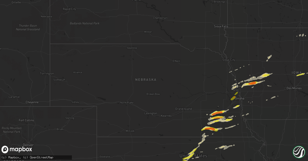
Hail Map in Nebraska on April 19, 2017
Get this storm
April 19 map
$229
one time, instant access
Download today. No call, no setup
Keep the $229
Bought the map and want the full workflow? Apply the entire $229 to a subscription within 7 days. None of it is wasted.
Every map, not just this one
This buys you this map. Subscription and you get every map we run, in the markets you choose from a few cities to whole states to nationwide. Plus real-time alerts the moment a storm fires.
Contact data
Name, contact info, occupancy, even credit band for addresses in the footprint. You go from where it hit to who to call.
Become the source they trust
Unlimited branding weather history reports on demand. You already have the documented answer ready for the property owner, and you are the one who showed up with it.
Property data and RoofTrace estimates
Pull up any address you have got, its value and the exact code rules for that jurisdiction, straight from One Click Code. Then RoofTrace estimates the squares, pitch, and roof value, priced the way you price.
Storm reports in Nebraska
Nebraska
| Date | Description |
|---|---|
| 04/19/20176:37 PM CDT | A local report indicates 1.00 inch wind near 4 S DOUGLAS |
| 04/19/20175:50 PM CDT | A local report indicates 1.75 inch wind near 10 N FAIRBURY |
| 04/19/20175:45 PM CDT | Hail up to quarter size. |
| 04/19/20175:37 PM CDT | A local report indicates 1.75 inch wind near 10 N FAIRBURY |
| 04/19/20175:26 PM CDT | 21st and cornhusker...hail covering ground |
| 04/19/20175:25 PM CDT | At the university of nebraska main campus |
| 04/19/20175:16 PM CDT | A local report indicates 1.00 inch wind near 4 W ALEXANDRIA |
| 04/19/20175:07 PM CDT | A local report indicates 60 MPH wind near PLEASANT DALE |
All States Impacted by Hail Map on April 19, 2017
Cities Impacted by Hail Map on April 19, 2017
- Cunningham, KS
- Arlington, KS
- Turon, KS
- Hamilton, KS
- Virgil, KS
- Sterling, KS
- Dola, OH
- Firth, NE
- Pomeroy, IA
- Fonda, IA
- Palmer, IA
- Jolley, IA
- Butler, IN
- Beloit, KS
- Auburn, IN
- Saint Joe, IN
- Spencerville, IN
- Harlan, IN
- Paulding, OH
- Hicksville, OH
- Antwerp, OH
- Cecil, OH
- Readlyn, IA
- Jamestown, KS
- Mcpherson, KS
- Bennington, KS
- Beverly, KS
- Barnard, KS
- Sylvan Grove, KS
- Lincoln, KS
- Minneapolis, KS
- Hunter, KS
- Tescott, KS
- Ada, OH
- Lima, OH
- Alger, OH
- Harrod, OH
- Weskan, KS
- Wallace, KS
- Sharon Springs, KS
- Winona, KS
- Kinsley, KS
- Belle Center, OH
- Waynesfield, OH
- Kenton, OH
- Plymouth, NE
- Jansen, NE
- Fairbury, NE
- Daykin, NE
- Lewis, KS
- Earling, IA
- Defiance, IA
- Panama, IA
- Salina, KS
- Denton, NE
- Milford, NE
- Pleasant Dale, NE
- Lincoln, NE
- Clatonia, NE
- Crete, NE
- Wilber, NE
- Douglas, NE
- Adams, NE
- Burr, NE
- Sterling, NE
- Cortland, NE
- Western, NE
- Martell, NE
- Hallam, NE
- Inman, KS
- Blair, NE
- Great Bend, KS
- Dunlap, IA
- Kirkman, IA
- Westphalia, IA
- Irwin, IA
- Harlan, IA
- Woodbine, IA
- Ellsworth, KS
- Kanopolis, KS
- Waterloo, IN
- Brookville, KS
- New Cambria, KS
- Offerle, KS
- Spearville, KS
- Haviland, KS
- Galveston, IN
- Logansport, IN
- Walton, IN
- Falun, KS
- Dorrance, KS
- Lucas, KS
- Lindsborg, KS
- Gypsum, KS
- Wilson, KS
- Simpson, KS
- Scandia, KS
- Bunker Hill, KS
- Geneseo, KS
- Concordia, KS
- Belleville, KS
- Solomon, KS
- Marquette, KS
- Portsmouth, IA
- Missouri Valley, IA
- Audubon, IA
- Manning, IA
- Logan, IA
- Massena, IA
- Bennet, NE
- Tekamah, NE
- Roca, NE
- Dorchester, NE
- Tobias, NE
- Alexandria, NE
- Beatrice, NE
- Albert, KS
- Dow City, IA
- Larned, KS
- Clear Lake, IA
- Fertile, IA
- Louisville, NE
- Weeping Water, NE
- Plattsmouth, NE
- Johnson, NE
- Moorhead, IA
- Pisgah, IA
- Gatlinburg, TN
- Percival, IA
- Brookpark, OH
- Cleveland, OH
- Berea, OH
- Lakeview, MI
- Mount Pleasant, MI
- Blanchard, MI
- Remus, MI
- Six Lakes, MI
- Covert, MI
- Niles, MI
- Pratt, KS
- Greensburg, KS
- Belvidere, NE
- Cedar Grove, WI
- Oostburg, WI
- Waldo, WI
- Herman, NE
- Modale, IA
- Waterville, KS
- Blue Rapids, KS
- Frankfort, KS
- Narka, KS
- Sheboygan Falls, WI
- Oakley, KS
- Lyons, KS
- Arcadia, IA
- Halbur, IA
- Carroll, IA
- Templeton, IA
- Glidden, IA
- Macy, NE
- Whiting, IA
- Ellinwood, KS
- Abilene, KS
- Chase, KS
- Raymond, KS
- Friend, NE
- Sprague, NE
- Syracuse, NE
- Hickman, NE
- Unadilla, NE
- Kensington, OH
- Minerva, OH
- East Rochester, OH
- Henry, TN
- Colo, IA
- Nevada, IA
- Murdock, NE
- Bloomville, OH
- Coloma, MI
- Barnes, KS
- Vermillion, KS
- Defiance, OH
- Oakwood, OH
- Munden, KS
- Cuba, KS
- Claflin, KS
- Mason City, IA
- Plymouth, IA
- Seward, NE
- Hornick, IA
- Sevierville, TN
- Glasco, KS
- Ravenna, OH
- Denison, IA
- Hubbell, NE
- Endicott, NE
- Beaver Crossing, NE
- Cordova, NE
- Alden, KS
- Monument, KS
- Edson, KS
- St John, KS
- Attica, OH
- Aurora, KS
- Blencoe, IA
- Little Sioux, IA
- Kokomo, IN
- Lorraine, KS
- Galva, KS
- Canton, KS
- Twin Lake, MI
- Guthrie Center, IA
- Danbury, IA
- Whitehall, MI
- Muskegon, MI
- Hoisington, KS
- Tecumseh, NE
- Grabill, IN
- Henderson, IA
- Corunna, IN
- Fontanelle, IA
- Greenfield, IA
- Stantonville, TN
- Ida Grove, IA
- Nickerson, KS
- Hutchinson, KS
- Byers, KS
- Iuka, KS
- Manly, IA
- Stafford, KS
- Partridge, KS
- Reynolds, NE
- Hebron, NE
- Garfield, KS
- Mondamin, IA
- State Center, IA
- Marshalltown, IA
- Republic, OH
- Crab Orchard, NE
- Filley, NE
- Plymouth, WI
- Abbyville, KS
- Oto, IA
- Smithland, IA
- Greenleaf, KS
- Pawnee Rock, KS
- Dedham, IA
- Ralston, IA
- Scranton, IA
- Manilla, IA
- Aspinwall, IA
- Arion, IA
- Macksville, KS
- Belpre, KS
- Silver City, IA
- Valparaiso, NE
- Willard, OH
- Centralia, KS
- Sylvia, KS
- Lytton, IA
- Delphos, KS
- Hamlin, IA
- Adair, IA
- Waverly, NE
- Alvo, NE
- Dunbar, NE
- Bangor, MI
- Sidney, IA
- Windom, KS
- Little River, KS
- Forest, IN
- Kensett, IA
- Hanlontown, IA
- Palmyra, NE
- Assaria, KS
- Edgerton, OH
- Bryan, OH
- Elkton, KY
- Olmitz, KS
- Elkhorn, NE
- Bennington, NE
- Waterloo, NE
- Omaha, NE
- Diller, NE
- Fort Calhoun, NE
- Tiffin, OH
- Sycamore, OH


