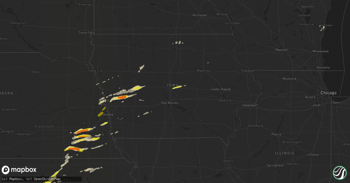
Hail Map in Iowa on April 19, 2017
Get this storm
April 19 map
$229
one time, instant access
Download today. No call, no setup
Keep the $229
Bought the map and want the full workflow? Apply the entire $229 to a subscription within 7 days. None of it is wasted.
Every map, not just this one
This buys you this map. Subscription and you get every map we run, in the markets you choose from a few cities to whole states to nationwide. Plus real-time alerts the moment a storm fires.
Contact data
Name, contact info, occupancy, even credit band for addresses in the footprint. You go from where it hit to who to call.
Become the source they trust
Unlimited branding weather history reports on demand. You already have the documented answer ready for the property owner, and you are the one who showed up with it.
Property data and RoofTrace estimates
Pull up any address you have got, its value and the exact code rules for that jurisdiction, straight from One Click Code. Then RoofTrace estimates the squares, pitch, and roof value, priced the way you price.
Storm reports in Iowa
Iowa
| Date | Description |
|---|---|
| 04/18/201710:24 PM CDT | Storage shed damaged. Delayed report. |
| 04/18/201710:19 PM CDT | Large tree and flag pole blown down. |
| 04/18/201710:13 PM CDT | 8 trees felled by strong winds. Report relayed by nws employee. Time estimated by radar. |
| 04/18/201710:13 PM CDT | 30 foot camper tipped over by strong winds. Delayed report. |
| 04/18/201710:08 PM CDT | Large tree down. Partial roof removed from morton building. Report relayed by nws employee. Time estimated by radar. |
| 04/18/201710:05 PM CDT | Trees down. Report relayed by nws employee. Time estimated by radar. |
| 04/18/20179:59 PM CDT | Tree damage reported. Extent unknown. Report relayed by nws employee. Time estimated by radar. |
| 04/18/20179:25 PM CDT | Small tree limbs down. |
| 04/18/20179:24 PM CDT | Iowa dot and hamiltion county dispatch reported downed powerlines/powerpoles over hwy 69 south of jewell. |
| 04/18/20178:33 PM CDT | Pea size hail and water ponding in the streets as well. |
| 04/18/20178:04 PM CDT | Carroll county dispatch relayed reports of machine shed with roof and doors blown off. |
| 04/18/20178:00 PM CDT | Chaser reported a tornado touched down just sw of carroll. Trees down and damage to a few out buildings. Time radar estimated. |
| 04/18/20177:54 PM CDT | Trained spotter reported damage in halbur... Including power lines down and overturned camper. Time radar estimated. |
| 04/18/20177:41 PM CDT | A local report indicates 1.75 inch wind near 3 S DEFIANCE |
| 04/18/20177:40 PM CDT | Hail mostly dime to nickel size...but some up to quarter size. |
All States Impacted by Hail Map on April 19, 2017
Cities Impacted by Hail Map on April 19, 2017
- Cunningham, KS
- Arlington, KS
- Turon, KS
- Hamilton, KS
- Virgil, KS
- Sterling, KS
- Dola, OH
- Firth, NE
- Pomeroy, IA
- Fonda, IA
- Palmer, IA
- Jolley, IA
- Butler, IN
- Beloit, KS
- Auburn, IN
- Saint Joe, IN
- Spencerville, IN
- Harlan, IN
- Paulding, OH
- Hicksville, OH
- Antwerp, OH
- Cecil, OH
- Readlyn, IA
- Jamestown, KS
- Mcpherson, KS
- Bennington, KS
- Beverly, KS
- Barnard, KS
- Sylvan Grove, KS
- Lincoln, KS
- Minneapolis, KS
- Hunter, KS
- Tescott, KS
- Ada, OH
- Lima, OH
- Alger, OH
- Harrod, OH
- Weskan, KS
- Wallace, KS
- Sharon Springs, KS
- Winona, KS
- Kinsley, KS
- Belle Center, OH
- Waynesfield, OH
- Kenton, OH
- Plymouth, NE
- Jansen, NE
- Fairbury, NE
- Daykin, NE
- Lewis, KS
- Earling, IA
- Defiance, IA
- Panama, IA
- Salina, KS
- Denton, NE
- Milford, NE
- Pleasant Dale, NE
- Lincoln, NE
- Clatonia, NE
- Crete, NE
- Wilber, NE
- Douglas, NE
- Adams, NE
- Burr, NE
- Sterling, NE
- Cortland, NE
- Western, NE
- Martell, NE
- Hallam, NE
- Inman, KS
- Blair, NE
- Great Bend, KS
- Dunlap, IA
- Kirkman, IA
- Westphalia, IA
- Irwin, IA
- Harlan, IA
- Woodbine, IA
- Ellsworth, KS
- Kanopolis, KS
- Waterloo, IN
- Brookville, KS
- New Cambria, KS
- Offerle, KS
- Spearville, KS
- Haviland, KS
- Galveston, IN
- Logansport, IN
- Walton, IN
- Falun, KS
- Dorrance, KS
- Lucas, KS
- Lindsborg, KS
- Gypsum, KS
- Wilson, KS
- Simpson, KS
- Scandia, KS
- Bunker Hill, KS
- Geneseo, KS
- Concordia, KS
- Belleville, KS
- Solomon, KS
- Marquette, KS
- Portsmouth, IA
- Missouri Valley, IA
- Audubon, IA
- Manning, IA
- Logan, IA
- Massena, IA
- Bennet, NE
- Tekamah, NE
- Roca, NE
- Dorchester, NE
- Tobias, NE
- Alexandria, NE
- Beatrice, NE
- Albert, KS
- Dow City, IA
- Larned, KS
- Clear Lake, IA
- Fertile, IA
- Louisville, NE
- Weeping Water, NE
- Plattsmouth, NE
- Johnson, NE
- Moorhead, IA
- Pisgah, IA
- Gatlinburg, TN
- Percival, IA
- Brookpark, OH
- Cleveland, OH
- Berea, OH
- Lakeview, MI
- Mount Pleasant, MI
- Blanchard, MI
- Remus, MI
- Six Lakes, MI
- Covert, MI
- Niles, MI
- Pratt, KS
- Greensburg, KS
- Belvidere, NE
- Cedar Grove, WI
- Oostburg, WI
- Waldo, WI
- Herman, NE
- Modale, IA
- Waterville, KS
- Blue Rapids, KS
- Frankfort, KS
- Narka, KS
- Sheboygan Falls, WI
- Oakley, KS
- Lyons, KS
- Arcadia, IA
- Halbur, IA
- Carroll, IA
- Templeton, IA
- Glidden, IA
- Macy, NE
- Whiting, IA
- Ellinwood, KS
- Abilene, KS
- Chase, KS
- Raymond, KS
- Friend, NE
- Sprague, NE
- Syracuse, NE
- Hickman, NE
- Unadilla, NE
- Kensington, OH
- Minerva, OH
- East Rochester, OH
- Henry, TN
- Colo, IA
- Nevada, IA
- Murdock, NE
- Bloomville, OH
- Coloma, MI
- Barnes, KS
- Vermillion, KS
- Defiance, OH
- Oakwood, OH
- Munden, KS
- Cuba, KS
- Claflin, KS
- Mason City, IA
- Plymouth, IA
- Seward, NE
- Hornick, IA
- Sevierville, TN
- Glasco, KS
- Ravenna, OH
- Denison, IA
- Hubbell, NE
- Endicott, NE
- Beaver Crossing, NE
- Cordova, NE
- Alden, KS
- Monument, KS
- Edson, KS
- St John, KS
- Attica, OH
- Aurora, KS
- Blencoe, IA
- Little Sioux, IA
- Kokomo, IN
- Lorraine, KS
- Galva, KS
- Canton, KS
- Twin Lake, MI
- Guthrie Center, IA
- Danbury, IA
- Whitehall, MI
- Muskegon, MI
- Hoisington, KS
- Tecumseh, NE
- Grabill, IN
- Henderson, IA
- Corunna, IN
- Fontanelle, IA
- Greenfield, IA
- Stantonville, TN
- Ida Grove, IA
- Nickerson, KS
- Hutchinson, KS
- Byers, KS
- Iuka, KS
- Manly, IA
- Stafford, KS
- Partridge, KS
- Reynolds, NE
- Hebron, NE
- Garfield, KS
- Mondamin, IA
- State Center, IA
- Marshalltown, IA
- Republic, OH
- Crab Orchard, NE
- Filley, NE
- Plymouth, WI
- Abbyville, KS
- Oto, IA
- Smithland, IA
- Greenleaf, KS
- Pawnee Rock, KS
- Dedham, IA
- Ralston, IA
- Scranton, IA
- Manilla, IA
- Aspinwall, IA
- Arion, IA
- Macksville, KS
- Belpre, KS
- Silver City, IA
- Valparaiso, NE
- Willard, OH
- Centralia, KS
- Sylvia, KS
- Lytton, IA
- Delphos, KS
- Hamlin, IA
- Adair, IA
- Waverly, NE
- Alvo, NE
- Dunbar, NE
- Bangor, MI
- Sidney, IA
- Windom, KS
- Little River, KS
- Forest, IN
- Kensett, IA
- Hanlontown, IA
- Palmyra, NE
- Assaria, KS
- Edgerton, OH
- Bryan, OH
- Elkton, KY
- Olmitz, KS
- Elkhorn, NE
- Bennington, NE
- Waterloo, NE
- Omaha, NE
- Diller, NE
- Fort Calhoun, NE
- Tiffin, OH
- Sycamore, OH


