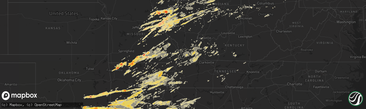
Hail Map in Mississippi on April 19, 2011
The weather event in Mississippi on April 19, 2011 includes Hail map. 16 states and 1,892 cities were impacted and suffered possible damage. The total estimated number of properties impacted is 0.
Want more than just the map?
Turn this storm into a full workflow.
- Owner + property data so you know who to knock
- OnDemand branded weather history reports to win the "did we even have hail?" argument
- RoofTrace estimate so reps stop guessing numbers at the door
Bought this map? Upgrade within 7 days and we'll credit the $230. (10-15 min setup call)
Hail
0
Estimated number of impacted properties by a 1.00" hail or larger0
Estimated number of impacted properties by a 1.75" hail or larger0
Estimated number of impacted properties by a 2.50" hail or largerStorm reports in Mississippi
Mississippi
| Date | Description |
|---|---|
| 04/19/20116:36 AM CDT | A local report indicates 1.00 inch wind near 3 NE ELLIOTT |
| 04/19/20116:15 AM CDT | A local report indicates 1.50 inch wind near 2 SW INVERNESS |
| 04/19/20115:37 AM CDT | A local report indicates 1.00 inch wind near 3 S DUCK HILL |
| 04/19/20115:27 AM CDT | A local report indicates 1.00 inch wind near ARCOLA |
| 04/19/20115:02 AM CDT | A local report indicates 1.00 inch wind near GRENADA |
| 04/19/20114:49 AM CDT | A local report indicates 1.00 inch wind near HOLCOMB |
| 04/19/20114:15 AM CDT | Trees down near the town of new wren. Various spots across northern monroe county have trees down. |
| 04/19/20114:05 AM CDT | Trees down in the towns of amory and smithville. 2 homes in amory sustained damage due to trees falling. |
| 04/19/20114:05 AM CDT | Trees down near the town of woodland. |
| 04/19/20114:00 AM CDT | Trees down in the city of nettleton. Couple of homes damaged due to fallen trees. Eastern part of nettleton and rural points east are without power. |
| 04/19/20113:50 AM CDT | A few trees and power lines down along county roads 451 and 460 near the town of vardaman. |
| 04/19/20113:45 AM CDT | A local report indicates 1.00 inch wind near SHANNON |
| 04/19/20113:40 AM CDT | Wind gauge on roof of a house measured winds at 65 mph with gusts to 89 mph |
| 04/19/20113:40 AM CDT | A couple large trees are down across beech springs street near the wtva station in tupelo. |
| 04/19/20113:24 AM CDT | Trees down along hwy 9 north near the town of sarepta. |
| 04/19/20113:15 AM CDT | Power is out in parts of pontotoc |
| 04/19/20111:45 AM CDT | A local report indicates 1.75 inch wind near ALLIGATOR |
| 04/18/201111:10 PM CDT | A local report indicates 70 MPH wind near OLIVE BRANCH |
| 04/18/201111:10 PM CDT | A local report indicates 1.00 inch wind near OLIVE BRANCH |
| 04/18/201111:00 PM CDT | Quarter size hail in olive branch near goodman road and hwy 305. |
| 04/18/201110:45 PM CDT | Large tree limbs and branches down. |
| 04/18/201110:41 PM CDT | Large tree limbs and branches down. |
| 04/18/201110:41 PM CDT | Estimate of 70 mph winds and trees bending toward the ground. |
All States Impacted by Hail Map on April 19, 2011
Cities Impacted by Hail Map on April 19, 2011
- Eldred, IL
- Carrollton, IL
- Henning, TN
- Ripley, TN
- Olive Branch, MS
- Byhalia, MS
- Hernando, MS
- Marshall, AR
- Leslie, AR
- Carthage, AR
- Chardon, OH
- Montville, OH
- Pomona, MO
- Willow Springs, MO
- Haworth, OK
- Foreman, AR
- Roodhouse, IL
- White Hall, IL
- Hillview, IL
- Patterson, IL
- Greenfield, IL
- Annapolis, MO
- Des Arc, MO
- Holcomb, MS
- Scobey, MS
- Grenada, MS
- Coffeeville, MS
- Cascilla, MS
- Sturgis, MS
- Ackerman, MS
- Maben, MS
- Starkville, MS
- Mathiston, MS
- Orlando, FL
- Bauxite, AR
- Bryant, AR
- Benton, AR
- Jacksonville, AR
- North Little Rock, AR
- Sherwood, AR
- Scott, AR
- Lonsdale, AR
- Little Rock, AR
- Mabelvale, AR
- Alexander, AR
- Traskwood, AR
- Carlinville, IL
- Modesto, IL
- Hettick, IL
- Waverly, IL
- Virden, IL
- Girard, IL
- Franklin, IL
- Palmyra, IL
- East Carondelet, IL
- Columbia, IL
- Glen Carbon, IL
- Edwardsville, IL
- Collinsville, IL
- Saint Jacob, IL
- East Saint Louis, IL
- Troy, IL
- Dupo, IL
- Millstadt, IL
- Saint Louis, MO
- Granite City, IL
- Maryville, IL
- Caseyville, IL
- Madison, IL
- Hooks, TX
- New Boston, TX
- Gilson, IL
- Dahinda, IL
- Williamsfield, IL
- Atoka, OK
- Coalgate, OK
- Talihina, OK
- Honobia, OK
- Nashoba, OK
- Jonesboro, AR
- Eldon, IA
- Shawneetown, IL
- Ridgway, IL
- Junction, IL
- Hampton, AR
- New Haven, IN
- Woodburn, IN
- Arlington, TX
- Bedford, TX
- Euless, TX
- North Richland Hills, TX
- Hurst, TX
- Fort Worth, TX
- Martinsville, IL
- Dennison, IL
- Marshall, IL
- Casey, IL
- Kansas, IL
- Paris, IL
- West Terre Haute, IN
- Westfield, IL
- Warrenton, MO
- Marquand, MO
- Fredericktown, MO
- Hampton, KY
- Marion, KY
- Salem, KY
- Colt, AR
- McCrory, AR
- Cotton Plant, AR
- New Haven, MO
- Chamois, MO
- Freeburg, MO
- Westphalia, MO
- Berger, MO
- Hermann, MO
- Loose Creek, MO
- Linn, MO
- Morrison, MO
- Bonnots Mill, MO
- Eureka Springs, AR
- Huntsville, AR
- Berryville, AR
- Frankford, MO
- Curryville, MO
- Bowling Green, MO
- Spencer, IN
- Bowling Green, IN
- Crawfordsville, IN
- Stringtown, OK
- Comstock Park, MI
- Gates Mills, OH
- Cleveland, OH
- Lancaster, OH
- Sugar Grove, OH
- Bremen, OH
- Hopkinsville, KY
- Crofton, KY
- Millport, AL
- Kennedy, AL
- Vernon, AL
- Morgantown, KY
- Lewisburg, KY
- West Alexandria, OH
- Camden, OH
- Martin, TN
- Dresden, TN
- Bennington, OK
- Boswell, OK
- Arcadia, FL
- Trumann, AR
- Harrisburg, AR
- Marked Tree, AR
- Alligator, MS
- Duncan, MS
- Clarksdale, MS
- Ashdown, AR
- Wilton, AR
- Dierks, AR
- Richfield, OH
- Hinckley, OH
- Medina, OH
- New Florence, MO
- Eureka, MO
- House Springs, MO
- State University, AR
- Grapevine, TX
- Southlake, TX
- Dixon, MO
- Devils Elbow, MO
- Rolla, MO
- Vichy, MO
- Saint James, MO
- Newburg, MO
- Jerome, MO
- Hartford, KY
- Cadiz, KY
- Rosebud, MO
- Gerald, MO
- Harrell, AR
- Alvarado, TX
- Keene, TX
- Godley, TX
- Joshua, TX
- Cleburne, TX
- Burleson, TX
- Grandview, TX
- Hillsboro, TX
- Covington, TX
- Itasca, TX
- Milford, TX
- Mountain View, MO
- Saint Joseph, IL
- Section, AL
- Mason, TN
- Arlington, TN
- Gibson City, IL
- Foosland, IL
- Rogers, AR
- Elkton, KY
- Sharon Grove, KY
- Black Rock, AR
- Caledonia, MS
- Philipp, MS
- Minter City, MS
- Pulaski, IL
- Olmsted, IL
- Villa Ridge, IL
- Knobel, AR
- Corning, AR
- Marvell, AR
- Lexa, AR
- Poplar Grove, AR
- Lakeland, FL
- Plant City, FL
- Terre Haute, IN
- Rosedale, IN
- Higginson, AR
- Clarksville, TX
- Bowling Green, KY
- Wappapello, MO
- McGee, MO
- Pleasant Plains, AR
- Bradford, AR
- Camden, AR
- Pontotoc, MS
- Shannon, MS
- Wolfe City, TX
- Ladonia, TX
- Golden Eagle, IL
- Brussels, IL
- Saint Charles, MO
- O'Fallon, MO
- Hot Springs National Park, AR
- Bismarck, AR
- Gillespie, IL
- Raymond, IL
- Fieldon, IL
- Earth City, MO
- Cedar Hill, MO
- Pocahontas, IL
- Winchester, IL
- Elsah, IL
- Pearl, IL
- Greenville, IL
- Piasa, IL
- Altamont, IL
- Grafton, IL
- Loami, IL
- Alton, IL
- Valmeyer, IL
- Hillsboro, IL
- Pleasant Hill, IL
- Bingham, IL
- New Douglas, IL
- Litchfield, IL
- Mount Olive, IL
- West Alton, MO
- Rockport, IL
- Stewardson, IL
- Bland, MO
- Saint Peters, MO
- Valley Park, MO
- O'Fallon, IL
- Wright City, MO
- Clarksville, MO
- Shipman, IL
- Fenton, MO
- Ballwin, MO
- Florissant, MO
- Catawissa, MO
- Alexander, IL
- Hamel, IL
- Saint Clair, MO
- Mulberry Grove, IL
- Neoga, IL
- Beecher City, IL
- Nebo, IL
- Fairview Heights, IL
- Imperial, MO
- Portage Des Sioux, MO
- Bethalto, IL
- Saint Ann, MO
- Trilla, IL
- Brownstown, IL
- Godfrey, IL
- Murrayville, IL
- Coffeen, IL
- Owensville, MO
- High Ridge, MO
- Brighton, IL
- Taylor Springs, IL
- Panama, IL
- Augusta, MO
- Beaufort, MO
- Lerna, IL
- Maryland Heights, MO
- Hartford, IL
- Jefferson City, MO
- Donnellson, IL
- Effingham, IL
- Leslie, MO
- Marine, IL
- Dow, IL
- Worden, IL
- Pacific, MO
- Alhambra, IL
- Union, MO
- Jerseyville, IL
- Wildwood, MO
- Hazelwood, MO
- Dittmer, MO
- Bunker Hill, IL
- Fidelity, IL
- Cowden, IL
- Lake Saint Louis, MO
- Medora, IL
- Staunton, IL
- Defiance, MO
- Bridgeton, MO
- Chesterfield, IL
- Dorsey, IL
- Jacksonville, IL
- Toledo, IL
- Belleville, IL
- Foristell, MO
- Roxana, IL
- Lonedell, MO
- Lebanon, IL
- Fillmore, IL
- Livingston, IL
- Sigel, IL
- Old Monroe, MO
- Chesterfield, MO
- Shumway, IL
- Robertsville, MO
- Pittsfield, IL
- Moro, IL
- Waggoner, IL
- Wentzville, MO
- Highland, IL
- Sorento, IL
- Kane, IL
- Cottage Hills, IL
- Walshville, IL
- Washington, MO
- East Alton, IL
- Belle, MO
- Marthasville, MO
- Louisiana, MO
- Arnold, MO
- Ramsey, IL
- Wood River, IL
- Nilwood, IL
- Kampsville, IL
- Thebes, IL
- Benton, MO
- Advance, MO
- Oran, MO
- Bell City, MO
- Scott City, MO
- Madisonville, KY
- Sacramento, KY
- Vernon, IL
- Kinmundy, IL
- Alma, IL
- Patoka, IL
- Lead Hill, AR
- Harrison, AR
- Lane, OK
- Saint Augustine, IL
- Avon, IL
- Decatur, IL
- Oreana, IL
- Calhoun City, MS
- Frisco, TX
- Little Elm, TX
- Rushville, IL
- Mount Sterling, IL
- Frederick, IL
- Wellsville, MO
- Vandalia, MO
- Middletown, MO
- Vilonia, AR
- Romance, AR
- Enola, AR
- Mount Vernon, AR
- Denton, TX
- Pine Bluff, AR
- Rison, AR
- Houston, MS
- Mayflower, AR
- Squires, MO
- Wasola, MO
- Noble, MO
- Ava, MO
- Powderly, TX
- Dekalb, IL
- Painesville, OH
- Saint Louisville, OH
- Utica, OH
- Quitman, AR
- Aberdeen, MS
- Okolona, MS
- McCarley, MS
- Duck Hill, MS
- Avery, TX
- Annona, TX
- De Kalb, TX
- Jewett, IL
- Farina, IL
- Hidalgo, IL
- Mason, IL
- Wheeler, IL
- Carlyle, IL
- Dieterich, IL
- Vandalia, IL
- Saint Peter, IL
- Greenup, IL
- West Union, IL
- Yale, IL
- Montrose, IL
- Newton, IL
- Watson, IL
- Edgewood, IL
- Shobonier, IL
- Inverness, MS
- Belzoni, MS
- Greenville, MS
- Isola, MS
- Leland, MS
- Hollandale, MS
- Indianola, MS
- Violet Hill, AR
- Franklin, AR
- Saint Michael, PA
- Sidman, PA
- Claysburg, PA
- Johnstown, PA
- Portage, PA
- Beaverdale, PA
- South Fork, PA
- Summerhill, PA
- East Freedom, PA
- Salix, PA
- Roaring Spring, PA
- Sherman, TX
- Tamms, IL
- Ullin, IL
- Lockesburg, AR
- Clayton, IL
- Timewell, IL
- Camden, IL
- Guilford, IN
- Sunman, IN
- Lawrenceburg, IN
- Harrison, OH
- West Harrison, IN
- Morganfield, KY
- Waverly, KY
- Muse, OK
- Smithville, OK
- Whitesboro, OK
- Hodgen, OK
- Grand Rivers, KY
- Calvert City, KY
- Brighton, IA
- Lockridge, IA
- Mount Pleasant, IA
- Fairfield, IA
- Wayland, IA
- Paris, MS
- Water Valley, MS
- Oxford, MS
- Crowley, TX
- Waterloo, IL
- White Hall, AR
- Springdale, AR
- Fayetteville, AR
- Hindsville, AR
- Peel, AR
- Yellville, AR
- Northbrook, IL
- Peoria, IL
- East Peoria, IL
- Creve Coeur, IL
- Somerville, TN
- Rushville, IN
- Brookville, IN
- Laurel, IN
- Oldenburg, IN
- Greensburg, IN
- Metamora, IN
- New Madrid, MO
- Catron, MO
- Matthews, MO
- Bertrand, MO
- East Prairie, MO
- Brownsville, TN
- Tillar, AR
- Evansville, IN
- Centertown, KY
- Sinclairville, NY
- Fort Leonard Wood, MO
- Dexter, KY
- Almo, KY
- Murray, KY
- Palestine, AR
- Roland, AR
- Silva, MO
- Malvern, AR
- Blue Eye, MO
- Lampe, MO
- Rome, OH
- Orwell, OH
- Russellville, KY
- Friendship, TN
- Trenton, TN
- Halls, TN
- Dyersburg, TN
- Montverde, FL
- Salem, MO
- Divernon, IL
- Dover, OH
- New Philadelphia, OH
- Bismarck, IL
- Danville, IL
- Oakwood, IL
- Hendrix, OK
- Savoy, TX
- Bells, TX
- Ravenna, TX
- Denison, TX
- Londonderry, OH
- Chillicothe, OH
- Elizabethtown, IL
- Joiner, AR
- Batesville, AR
- Floral, AR
- Kensett, AR
- Searcy, AR
- Judsonia, AR
- Casa, AR
- Kennett, MO
- Hornersville, MO
- Cardwell, MO
- Senath, MO
- Arbyrd, MO
- Heavener, OK
- Mena, AR
- Morgantown, IN
- Ravenden, AR
- Ravenden Springs, AR
- Waynesville, MO
- La Center, KY
- Obion, TN
- Hornbeak, TN
- Lake Village, AR
- Argyle, TX
- Ponder, TX
- Justin, TX
- Krum, TX
- Arkadelphia, AR
- Fulton, AR
- Stephens, AR
- Leola, AR
- Ivanhoe, TX
- Gurdon, AR
- Washington, AR
- Arthur City, TX
- Thornton, AR
- Rosston, AR
- Fordyce, AR
- Paris, TX
- Mineral Springs, AR
- Friendship, AR
- Bluff City, AR
- Chidester, AR
- Emmet, AR
- Sheridan, AR
- Idabel, OK
- Okolona, AR
- Winthrop, AR
- Jersey, AR
- Donaldson, AR
- De Queen, AR
- Amity, AR
- Howe, TX
- Bonham, TX
- Kingsland, AR
- Detroit, TX
- Delight, AR
- Banks, AR
- Sumner, TX
- Eagletown, OK
- Sparkman, AR
- Hope, AR
- Alleene, AR
- Saratoga, AR
- Horatio, AR
- Honey Grove, TX
- Bagwell, TX
- Brookston, TX
- Murfreesboro, AR
- Poyen, AR
- Prescott, AR
- Antoine, AR
- Bearden, AR
- Warren, AR
- Telephone, TX
- Blevins, AR
- Nashville, AR
- New Edinburg, AR
- Blossom, TX
- McCaskill, AR
- Granbury, TX
- Rio Vista, TX
- Vardaman, MS
- Pittsboro, MS
- Houlka, MS
- Jefferson, OH
- Ashtabula, OH
- Munroe Falls, OH
- Akron, OH
- Tallmadge, OH
- Stow, OH
- Kent, OH
- Oak Brook, IL
- Dallas, TX
- Pangburn, AR
- Lowell, AR
- Tremont, MS
- Colleyville, TX
- Gilbertsville, KY
- Hickory Ridge, AR
- Cherry Valley, AR
- Wynne, AR
- Argenta, IL
- Cisco, IL
- Norman, AR
- Mount Ida, AR
- Mt Zion, IL
- Dalton City, IL
- Dudley, MO
- Dexter, MO
- Schlater, MS
- West Plains, MO
- Birch Tree, MO
- Peace Valley, MO
- Princeton, KY
- Eddyville, KY
- Springfield, AR
- Greenbrier, AR
- Damascus, AR
- Lewisville, TX
- The Colony, TX
- Camp, AR
- Glencoe, AR
- Quincy, IN
- Stilesville, IN
- Monrovia, IN
- Cloverdale, IN
- Clayton, IN
- Greencastle, IN
- Fillmore, IN
- Coatesville, IN
- Martinsville, IN
- Shelbyville, IN
- Alpena, AR
- Green Forest, AR
- Oconee, IL
- Grapevine, AR
- Princeville, IL
- Dunlap, IL
- Edelstein, IL
- Speer, IL
- Plainview, AR
- Moores Hill, IN
- Milan, IN
- Aurora, IN
- Ellsinore, MO
- Grandin, MO
- Williamsville, MO
- Poplar Bluff, MO
- Saint David, IL
- Bryant, IL
- Elmwood, IL
- Hanna City, IL
- Cuba, IL
- Canton, IL
- Glasford, IL
- Wyoming, IL
- Trivoli, IL
- Farmington, IL
- Norris, IL
- Sparland, IL
- Lewistown, IL
- Brimfield, IL
- Mapleton, IL
- Falconer, NY
- Kennedy, NY
- Duke, MO
- Bradyville, TN
- Morrison, TN
- Klondike, TX
- Sulphur Springs, TX
- Cooper, TX
- Commerce, TX
- Dike, TX
- Pecan Gap, TX
- Colbert, OK
- Monroeville, IN
- Roann, IN
- Denver, IN
- Macy, IN
- Pollard, AR
- Piggott, AR
- Manchester, TN
- Wartrace, TN
- Beechgrove, TN
- De Soto, MO
- Brickeys, AR
- Marianna, AR
- Smithland, KY
- Tiline, KY
- Commerce Township, MI
- White Lake, MI
- Prairie Grove, AR
- Golden, MO
- Hollister, MO
- Elkins, AR
- Garfield, AR
- Oak Grove, AR
- Eagle Rock, MO
- Shell Knob, MO
- Farmington, AR
- Ridgedale, MO
- Omaha, AR
- Patton, MO
- Perryville, MO
- Waldron, AR
- Protem, MO
- Gosport, IN
- Bloomington, IN
- Ellettsville, IN
- Houston, MO
- Eudora, AR
- Itta Bena, MS
- Moorhead, MS
- Piedmont, MO
- Van Buren, MO
- Swifton, AR
- Tuckerman, AR
- Parthenon, AR
- Jasper, AR
- Deer, AR
- Hasty, AR
- Vendor, AR
- Benton, KY
- Ingraham, IL
- Tyronza, AR
- Wilmar, AR
- Pearcy, AR
- Tucker, AR
- Moyers, OK
- Hunter, AR
- Letona, AR
- Desha, AR
- Star City, AR
- Amagon, AR
- Walnut Ridge, AR
- Gilmore, AR
- Heber Springs, AR
- Alicia, AR
- Oil Trough, AR
- Beebe, AR
- Bald Knob, AR
- Burlison, TN
- Des Arc, AR
- Newark, AR
- Cartwright, OK
- Newhope, AR
- Clayton, OK
- Bokchito, OK
- Hot Springs Village, AR
- Wabbaseka, AR
- Fairfield Bay, AR
- Sherrill, AR
- Harvey, AR
- Paron, AR
- England, AR
- De Valls Bluff, AR
- Crawfordsville, AR
- Fisher, AR
- Rosie, AR
- Russell, AR
- Hensley, AR
- Snow, OK
- Brookland, AR
- Whitewright, TX
- El Paso, AR
- Yorktown, AR
- Ida, AR
- Boles, AR
- Wilson, AR
- Prim, AR
- Altheimer, AR
- Wilburn, AR
- Turrell, AR
- Humnoke, AR
- Griffithville, AR
- Conway, AR
- McRae, AR
- Bee Branch, AR
- Shirley, AR
- Maumelle, AR
- Tumbling Shoals, AR
- Concord, AR
- Prattsville, AR
- Drummonds, TN
- Parks, AR
- Grady, AR
- Augusta, AR
- Little Rock Air Force Base, AR
- Dyess, AR
- Bassett, AR
- Hazen, AR
- Thida, AR
- Parkin, AR
- Antlers, OK
- Earle, AR
- Austin, AR
- Sulphur Rock, AR
- Ozan, AR
- Wapanucka, OK
- Mountain View, AR
- Weiner, AR
- Rattan, OK
- Charlotte, AR
- Edgemont, AR
- Bono, AR
- Lepanto, AR
- Gillham, AR
- Osceola, AR
- Ulm, AR
- Stuttgart, AR
- Garner, AR
- Locust Grove, AR
- Umpire, AR
- Frenchmans Bayou, AR
- Albion, OK
- Rose Bud, AR
- Hermitage, AR
- Bigelow, AR
- Drasco, AR
- Calera, OK
- Magness, AR
- Brighton, TN
- Redfield, AR
- Carlisle, AR
- Beedeville, AR
- Perryville, AR
- Booneville, AR
- Newport, AR
- Daisy, OK
- Marcella, AR
- Higden, AR
- Jefferson, AR
- Roe, AR
- Durant, OK
- Tupelo, OK
- Kirby, AR
- Paragould, AR
- Cabot, AR
- Cord, AR
- Cash, AR
- Columbia, KY
- Springfield, IL
- Sherman, IL
- Elkhart, IL
- Lincoln, IL
- Middletown, IL
- Richland, MO
- Westport, IN
- Hartsville, IN
- Centertown, MO
- Punta Gorda, FL
- Tupelo, MS
- Amory, MS
- Plantersville, MS
- Nettleton, MS
- Fulton, MS
- Smithville, MS
- Sullivan, MO
- Tichnor, AR
- Oakland, TN
- Toulon, IL
- Hickman, KY
- Union City, TN
- Herrick, IL
- Rosamond, IL
- Pana, IL
- Tower Hill, IL
- Nokomis, IL
- Addieville, IL
- Moscow, TN
- Keller, TX
- Irving, TX
- Coppell, TX
- Grand Prairie, TX
- Plano, TX
- Flower Mound, TX
- Carrollton, TX
- Haltom City, TX
- Roanoke, TX
- Moscow Mills, MO
- Troy, MO
- Bourbon, MO
- Lambert, MS
- Cecil, OH
- Saint Francisville, IL
- Ona, FL
- Myakka City, FL
- Dunmor, KY
- Belton, KY
- Rochester, KY
- Woodland, MS
- Prairie, MS
- Wadsworth, OH
- Barberton, OH
- Camp Point, IL
- Equality, IL
- Herod, IL
- Harrisburg, IL
- Rockbridge, IL
- Oneida, TN
- Winfield, TN
- Jamestown, KY
- Eaton, OH
- Montgomery City, MO
- Millington, TN
- Memphis, TN
- Gunnison, MS
- Mellwood, AR
- Snow Lake, AR
- Crumrod, AR
- Gillett, AR
- Benton Harbor, MI
- Hamburg, IL
- Batchtown, IL
- Elsberry, MO
- Morrilton, AR
- Ola, AR
- Brazil, IN
- Rockville, IN
- Laura, IL
- Doddsville, MS
- Thornfield, MO
- Cambridge Springs, PA
- Streetsboro, OH
- Mantua, OH
- Chagrin Falls, OH
- Hudson, OH
- Aurora, OH
- Chippewa Lake, OH
- Seville, OH
- Logansport, IN
- Williamsville, IL
- Campbell, MO
- Doe Run, MO
- Burton, OH
- Corydon, KY
- Mount Carroll, IL
- Howard, OH
- Danville, OH
- Mount Vernon, OH
- Gambier, OH
- Saint Paul, IN
- Flat Rock, IN
- Mansfield, TX
- Blum, TX
- Kennedale, TX
- Mayfield, KY
- Farmington, KY
- Steedman, MO
- Dewittville, NY
- Stockton, NY
- Charleston, IL
- Oakland, IL
- Licking, MO
- Big Creek, MS
- Bruce, MS
- Hillsboro, MO
- Gould, AR
- Brixey, MO
- Gainesville, MO
- Eminence, MO
- Summersville, MO
- Pawnee, IL
- Rochester, IL
- Edinburg, IL
- Blue Springs, MS
- Belden, MS
- Winona, MS
- Stewart, MS
- Kilmichael, MS
- Greenwood, MS
- Carrollton, MS
- Gore Springs, MS
- Eupora, MS
- North Carrollton, MS
- Whitesville, KY
- Fordsville, KY
- Dundee, KY
- Reynolds Station, KY
- Owensboro, KY
- Horse Cave, KY
- Jonesburg, MO
- Truxton, MO
- Hawk Point, MO
- Waterford, MI
- West Bloomfield, MI
- Hennepin, IL
- Hope, IN
- Laquey, MO
- Falcon, MO
- Fayette, AL
- Leesburg, FL
- Mascotte, FL
- Groveland, FL
- Allendale, MI
- Jenison, MI
- Marne, MI
- Hudsonville, MI
- Grand Rapids, MI
- Warm Springs, AR
- Couch, MO
- Pocahontas, AR
- Lynnville, TN
- Mount Pleasant, TN
- Summertown, TN
- Bedford, OH
- Twinsburg, OH
- Solon, OH
- Northfield, OH
- Macedonia, OH
- Peninsula, OH
- Brecksville, OH
- Bradford, IL
- Freedom, IN
- Worthington, IN
- Scott Air Force Base, IL
- Mascoutah, IL
- Clubb, MO
- Arcadia, MO
- Greenville, MO
- Hamilton, MS
- Cunningham, KY
- Kevil, KY
- Wickliffe, KY
- Paducah, KY
- West Paducah, KY
- Melber, KY
- Bardwell, KY
- Alton, MO
- Columbia Station, OH
- Olmsted Falls, OH
- Lonoke, AR
- Winona, MO
- Fremont, MO
- Theodosia, MO
- Richwoods, MO
- Leasburg, MO
- Fredonia, KY
- Rector, AR
- Waverly, OH
- Wilsonville, IL
- Benld, IL
- Waveland, IN
- Dermott, AR
- Arcadia, IN
- Cicero, IN
- Ellisville, IL
- Vina, AL
- Golden, MS
- Knox, IN
- Culver, IN
- Columbus Junction, IA
- Winfield, IA
- Wapello, IA
- Morning Sun, IA
- Tillatoba, MS
- Coila, MS
- Ashmore, IL
- Oblong, IL
- Willow Hill, IL
- Texarkana, TX
- Atlanta, IN
- Garland, TX
- Addison, TX
- Richardson, TX
- Elgin, IL
- Hoffman Estates, IL
- Clay, KY
- Moody, MO
- Foley, MO
- Winfield, MO
- Ellington, MO
- Sawyerville, IL
- Cape Fair, MO
- Galena, MO
- Reeds Spring, MO
- Waynetown, IN
- Dayton, OH
- Bolivar, TN
- Batavia, IA
- Libertyville, IA
- Attica, IN
- Bainbridge, IN
- Ash Flat, AR
- Forney, TX
- Knoxville, IL
- Maquon, IL
- Pottersville, MO
- Vanzant, MO
- Fairview, IL
- Ipava, IL
- Chillicothe, IL
- Brighton, MI
- Meadville, PA
- Defiance, OH
- Center Ridge, AR
- Vaiden, MS
- Brinkley, AR
- Holly Grove, AR
- Clarendon, AR
- Drury, MO
- Doniphan, MO
- Connersville, IN
- Geneva, OH
- Bragg City, MO
- Mound Bayou, MS
- Auburn, IL
- Thayer, IL
- Thayer, MO
- Windsor, IL
- Strasburg, IL
- New Berlin, IL
- Pleasant Plains, IL
- Melbourne, AR
- Arthur, IL
- Arcola, IL
- Hardin, KY
- Geneva, IL
- Saint Charles, IL
- Elburn, IL
- Madison, OH
- Perry, OH
- Centerville, MO
- Conneautville, PA
- Saegertown, PA
- Bridgeport, IL
- Hanson, KY
- Earlington, KY
- Island, KY
- Manitou, KY
- Sturdivant, MO
- Zalma, MO
- Puxico, MO
- Timbo, AR
- Onia, AR
- Vermont, IL
- La Fayette, IL
- Galva, IL
- Victoria, IL
- Altona, IL
- Cherokee Village, AR
- Hardy, AR
- New Lebanon, OH
- Vance, MS
- Angola, NY
- Irving, NY
- New London, MO
- Fisk, MO
- Holland, NY
- Franklin Park, IL
- Bensenville, IL
- Wood Dale, IL
- Winnetka, IL
- Niles, IL
- Park Ridge, IL
- Wilmette, IL
- Des Plaines, IL
- Morton Grove, IL
- Glenview, IL
- Golf, IL
- Kenilworth, IL
- Fredericktown, OH
- Oakland, AR
- Norwood, MO
- Pontiac, MO
- Zanoni, MO
- Dora, MO
- Isabella, MO
- Cedarcreek, MO
- Caulfield, MO
- Tecumseh, MO
- Whiteville, TN
- Mentor, OH
- Rockwall, TX
- Royse City, TX
- Troy, TN
- Casscoe, AR
- De Witt, AR
- Vulcan, MO
- Mount Pleasant, AR
- Guion, AR
- Unionville, IA
- East Aurora, NY
- Tutwiler, MS
- Enid, MS
- Batesville, MS
- Aubrey, AR
- Monroe, MI
- Dundee, MI
- Fort Wayne, IN
- Carbon, IN
- West College Corner, IN
- Liberty, IN
- Metropolis, IL
- Belknap, IL
- Saint Joe, AR
- Marble Falls, AR
- Western Grove, AR
- Ponca, AR
- Everton, AR
- Springfield, OH
- New Ross, IN
- Ladoga, IN
- Caraway, AR
- Rhineland, MO
- Hartsburg, MO
- Fulton, MO
- High Hill, MO
- Williamsburg, MO
- Mokane, MO
- Tebbetts, MO
- Holts Summit, MO
- Portland, MO
- New Bloomfield, MO
- Cabool, MO
- Cerro Gordo, IL
- Somerset, OH
- Junction City, OH
- Kinderhook, IL
- Bartow, FL
- Mooresville, IN
- Plainfield, IN
- Chandlerville, IL
- Humphrey, AR
- Spruce Pine, AL
- Hodges, AL
- Phil Campbell, AL
- Centrahoma, OK
- Winter Garden, FL
- Petersburg, MI
- Riga, MI
- Deerfield, MI
- Blissfield, MI
- Riley, IN
- Hazel, KY
- Sturgis, KY
- Leslie, MI
- Onondaga, MI
- Andover, OH
- Gays, IL
- Mattoon, IL
- Golconda, IL
- Whiteland, IN
- Bargersville, IN
- Franklin, IN
- Brookport, IL
- Boaz, KY
- Barlow, KY
- Fancy Farm, KY
- Hickory, KY
- Watson, AR
- Toone, TN
- Morrisonville, IL
- Eldorado, IL
- Clinton, KY
- Sidney, AR
- Smithville, TN
- Mcminnville, TN
- Patterson, MO
- Barry, IL
- Hull, IL
- Bridgeton, IN
- New Concord, KY
- Cottage Grove, TN
- Palmersville, TN
- Burna, KY
- Kuttawa, KY
- Providence, KY
- Ledbetter, KY
- Kirksey, KY
- Dukedom, TN
- Symsonia, KY
- Puryear, TN
- Sedalia, KY
- Koshkonong, MO
- Monticello, AR
- Lovington, IL
- Shelby, MS
- Coloma, MI
- Watervliet, MI
- Rensselaer, IN
- Greenville, KY
- Chadwick, MO
- Steens, MS
- Bethany, IL
- Mounds, IL
- Butler, OH
- Auburn, KY
- Noblesville, IN
- Saint Joseph, MI
- La Fontaine, IN
- Marion, IN
- Fifty Six, AR
- Tilly, AR
- Jerusalem, AR
- Hector, AR
- Dennard, AR
- Zeeland, MI
- Smithville, AR
- Strawberry, AR
- Bliss, NY
- Brooklyn, MI
- Manchester, MI
- Cherry Creek, NY
- Onarga, IL
- Gilman, IL
- Crescent City, IL
- Chaffee, MO
- Holly Springs, MS
- Lamar, MS
- Rossville, TN
- Red Banks, MS
- Lawtons, NY
- North Collins, NY
- Sainte Genevieve, MO
- Farmington, MO
- Bonne Terre, MO
- Lake City, AR
- Monette, AR
- Leachville, AR
- Columbus, MS
- Gray Summit, MO
- Villa Ridge, MO
- Erie, PA
- Arlington, IL
- Macon, IL
- Steelville, MO
- Adona, AR
- Industry, IL
- Eads, TN
- Marion, AR
- Rueter, MO
- Sidney, IL
- Ogden, IL
- Philo, IL
- Homer, IL
- Moro, AR
- Southaven, MS
- Nesbit, MS
- Cincinnati, OH
- Alamo, TN
- Arlington Heights, IL
- Prospect Heights, IL
- Wheeling, IL
- Mount Prospect, IL
- Rock Creek, OH
- Thompson, OH
- Aubrey, TX
- Sanger, TX
- Sugar Grove, IL
- Riverton, IL
- Dawson, IL
- Buffalo, IL
- Jeffersonville, OH
- Middlefield, OH
- Charleston, MO
- Sachse, TX
- Duncanville, TX
- Mesquite, TX
- Rowlett, TX
- Terrell, TX
- Balch Springs, TX
- Wylie, TX
- Loudonville, OH
- Covington, IN
- Westville, IL
- Williamsport, IN
- Tilton, IL
- Lehigh Acres, FL
- Kingman, IN
- Hillsboro, IN
- Wingate, IN
- New Richmond, IN
- Veedersburg, IN
- Bloomfield, MO
- Sikeston, MO
- Essex, MO
- Belleview, MO
- Ironton, MO
- Lesterville, MO
- Woodville, AL
- Hoyleton, IL
- Centralia, IL
- Okawville, IL
- Nashville, IL
- Hoffman, IL
- Redford, MO
- Hardenville, MO
- Bunker, MO
- Black, MO
- Elk Creek, MO
- Bismarck, MO
- Middle Brook, MO
- Mill Spring, MO
- Park Hills, MO
- Dumas, AR
- Quincy, MI
- Tekonsha, MI
- Homer, MI
- Manila, AR
- Pavilion, NY
- Cypress, IL
- Bay, AR
- Umatilla, FL
- Wheatfield, IN
- Cayuga, IN
- Linden, IN
- Perrysville, IN
- Colfax, IN
- Darlington, IN
- Nebo, KY
- Dawson Springs, KY
- Etowah, AR
- Beulah, MS
- Benoit, MS
- Wideman, AR
- Oxford, AR
- Portland, AR
- Parkdale, AR
- Bowerston, OH
- Catlin, IL
- Fairmount, IL
- College Corner, OH
- Manilla, IN
- French Camp, MS
- New Hope, AL
- Monon, IN
- Beaver Dam, KY
- Olaton, KY
- Rosine, KY
- Horse Branch, KY
- Clinton, AR
- Illiopolis, IL
- Success, MO
- Oakland, MS
- Xenia, OH
- Alpha, OH
- Bellbrook, OH
- Hamilton, AL
- North East, PA
- Lewisburg, OH
- Mount Pulaski, IL
- Hamburg, NY
- Orchard Park, NY
- Peru, IN
- Aurora, IL
- North Aurora, IL
- Astoria, IL
- Colchester, IL
- Henry, IL
- Smithfield, IL
- Table Grove, IL
- Adair, IL
- Macomb, IL
- Plymouth, IL
- Edwards, IL
- Black Oak, AR
- Eugene, MO
- Henley, MO
- Cave In Rock, IL
- Champaign, IL
- Savoy, IL
- Tolono, IL
- Bloomfield, IA
- Freeburg, IL
- Novelty, OH
- Chesterland, OH
- Moweaqua, IL
- Tuscola, IL
- Humboldt, IL
- Sullivan, IL
- Poland, IN
- Edinburgh, IN
- Sandborn, IN
- Huntington, IN
- Andrews, IN
- Wabash, IN
- Rush Hill, MO
- Laddonia, MO
- Bells, TN
- Gadsden, TN
- Derby, NY
- Eden, NY
- Lake Cormorant, MS
- Somerdale, OH
- Mineral City, OH
- Stonington, IL
- Dorset, OH
- Mount Vernon, IN
- Novi, MI
- Northville, MI
- Randolph, MS
- Hoagland, IN
- Crossville, TN
- Uhrichsville, OH
- Tippecanoe, OH
- Scio, OH
- Arlington, KY
- Sandwich, IL
- Somonauk, IL
- Jamestown, OH
- Fountaintown, IN
- Coal City, IN
- Auxvasse, MO
- Ward, AR
- New Haven, IL
- Henderson, TN
- Dellroy, OH
- Carrollton, OH
- Aviston, IL
- Breese, IL
- Rosiclare, IL
- Ethridge, TN
- Paragon, IN
- Johnsonville, IL
- Tiptonville, TN
- Ecru, MS
- Pickens, AR
- New Canton, IL
- Sims, IL
- Guntersville, AL
- Arab, AL
- Centerpoint, IN
- Reelsville, IN
- Amo, IN
- Danville, IN
- Labadie, MO
- Willoughby, OH
- Fulton, KY
- Cambridge, OH
- Maynard, AR
- Pesotum, IL
- Claypool, IN
- Frazeysburg, OH
- Walhonding, OH
- Bath, IL
- Bloomfield, IN
- Silver Lake, IN
- Williford, AR
- Poughkeepsie, AR
- Drakesville, IA
- Brookville, OH
- Saffell, AR
- Wingo, KY
- Water Valley, KY
- Russellville, MO
- Lohman, MO
- Newbury, OH
- Center, MO
- New Hudson, MI
- South Lyon, MI
- Wixom, MI
- Milford, MI
- Havana, IL
- Hamilton, OH
- Coldwater, MS
- Fairland, IN
- Tullahoma, TN
- Smithton, IL
- Allegan, MI
- Grand Junction, MI
- Pullman, MI
- Edinboro, PA
- Kirbyville, MO
- Powersite, MO
- Oneida, IL
- Galesburg, IL
- Lockbourne, OH
- Ashville, OH
- Grand Chain, IL
- Saltillo, MS
- Columbus, IN
- Lyon, MS
- Pope, MS
- Charleston, MS
- Drew, MS
- West Chicago, IL
- Plainfield, IL
- Romeoville, IL
- Bolingbrook, IL
- Twelve Mile, IN
- Crawford, MS
- Medon, TN
- Cordova, TN
- Stanton, TN
- Atoka, TN
- Germantown, TN
- Unionville, TN
- Christiana, TN
- Bell Buckle, TN
- Rockvale, TN
- Thawville, IL
- Roberts, IL
- Loda, IL
- Buckley, IL
- Nortonville, KY
- Chestnutridge, MO
- Winchester, AR
- Celeste, TX
- Rohwer, AR
- Caledonia, NY
- Le Roy, NY
- Fennville, MI
- Falls Of Rough, KY
- Rosedale, MS
- Bement, IL
- Fithian, IL
- Oxford, OH
- Okeana, OH
- Odin, IL
- Sandoval, IL
- Hinckley, IL
- Maple Park, IL
- De Land, IL
- Abingdon, IL
- West, MS
- Greenwood Springs, MS
- Red Bay, AL
- Perrysville, OH
- Collierville, TN
- Prairie Du Rocher, IL
- Forrest City, AR
- Haynes, AR
- Owens Cross Roads, AL
- Brownsboro, AL
- Readyville, TN
- Horton, MI
- Kingston, OK
- Madill, OK
- Delta, OH
- Marshall, IN
- Bloomingdale, IN
- Pilot Point, TX
- Centerville, IN
- Brownsville, IN
- Saint Elmo, IL
- Winfield, IL
- Villa Park, IL
- Lombard, IL
- Glen Ellyn, IL
- Addison, IL
- Wheaton, IL
- Warrenville, IL
- Naperville, IL
- Plano, IL
- Grafton, OH
- Lagrange, OH
- Winamac, IN
- North Judson, IN
- Medaryville, IN
- Antwerp, OH
- Bloomingburg, OH
- Brookston, IN
- Delphi, IN
- Battle Ground, IN
- Saint Thomas, MO
- Woodbury, TN
- Murfreesboro, TN
- Linesville, PA
- Wheatley, AR
- Littleton, IL
- Georgetown, IL
- Indianola, IL
- Allerton, IL
- Sidell, IL
- Ridge Farm, IL
- Smithboro, IL
- Nashville, IN
- Huntsburg, OH
- Harlan, IN
- Gurley, AL
- Wayne, IL
- Roselle, IL
- Elk Grove Village, IL
- Bartlett, IL
- Carol Stream, IL
- Hanover Park, IL
- Schaumburg, IL
- Bloomingdale, IL
- Mammoth Spring, AR
- Horseshoe Bend, AR
- Union City, PA
- Lilbourn, MO
- Portageville, MO
- Marston, MO
- Independence, OH
- Sturkie, AR
- Salem, AR
- Donovan, IL
- Brook, IN
- Kentland, IN
- Sheldon, IL
- Iroquois, IL
- Morocco, IN
- Potosi, MO
- Crocker, MO
- Normandy, TN
- McCool, MS
- Farmington, MI
- Southfield, MI
- Livonia, MI
- Farmersburg, IN
- Parma, MO
- Malden, MO
- Owaneco, IL
- Flippin, AR
- Pittsford, MI
- North Adams, MI
- Munford, TN
- Ethel, MS
- Hutsonville, IL
- Annapolis, IL
- Robinson, IL
- Farber, MO
- Glenwood, AR
- Bonnerdale, AR
- Lyons, IN
- Tiskilwa, IL
- Princeton, IL
- Bureau, IL
- Watseka, IL
- Washington, IL
- Harriet, AR
- Big Flat, AR
- Ethelsville, AL
- Witt, IL
- Lakewood, IL
- Powhatan, AR
- Portia, AR
- Hoxie, AR
- Lynn, AR
- Hammond, IL
- Milmine, IL
- Barnhart, MO
- Pevely, MO
- Eastview, KY
- Fletcher, MO
- Sadorus, IL
- Urbana, IL
- Atwood, IL
- Ivesdale, IL
- Keenes, IL
- Imboden, AR
- Monterey, IN
- Mississippi State, MS
- Laceys Spring, AL
- Somerville, AL
- Valhermoso Springs, AL
- Russell Springs, KY
- Burkesville, KY
- Glens Fork, KY
- Albany, KY
- Breeding, KY
- Sumner, MS
- Cleveland, MS
- Keiser, AR
- Delevan, NY
- Arcade, NY
- Rochester, IN
- Farmersville, OH
- South Fulton, TN
- Dorr, MI
- Byron Center, MI
- Noble, IL
- Ravenna, OH
- Pierpont, OH
- Fox, AR
- London Mills, IL
- Bellevue, MI
- Nashville, MI
- Central City, KY
- Glenarm, IL
- Rocky River, OH
- Lakewood, OH
- Thaxton, MS
- Yates City, IL
- Dana, IN
- Taylorsville, IN
- Helenwood, TN
- Crocketts Bluff, AR
- Almyra, AR
- Shaw, MS
- Belmont, NY
- Jeromesville, OH
- Rankin, IL
- Cissna Park, IL
- Blue Mound, IL
- Saint Robert, MO
- Venice, IL
- Martinsburg, MO
- Harvel, IL
- New Goshen, IN
- South Roxana, IL
- Butler, IL
- Woodson, IL
- Teutopolis, IL
- Milton, IL
- Chatham, IL
- Wrights, IL
- Trenton, IL
- West York, IL
- Farmersville, IL
- Hardin, IL
- Staunton, IN
- Knightsville, IN
- Harmony, IN
- Cape Girardeau, MO
- Plumerville, AR
- Austinburg, OH
- Fair Oaks, IN
- Calhoun, KY
- Utica, KY
- Scottsboro, AL
- Mount Hope, AL
- Brocton, IL
- White Plains, KY
- La Place, IL
- Mantee, MS
- Rockfield, KY
- Marissa, IL
- Lenzburg, IL
- Coulterville, IL
- Oakdale, IL
- Mendon, MI
- Shelbyville, IL
- Williamsfield, OH
- Warsaw, OH
- Langley, AR
- Putnam, IL
- Browder, KY
- Drakesboro, KY
- Valley City, OH
- Rittman, OH
- Germantown, OH
- Liverpool, IL
- Mecca, IN
- Montezuma, IN
- Hillsdale, IN
- Clinton, IN
- Washington Court House, OH
- North Manchester, IN
- Frankfort, IN
- Clarks Hill, IN
- Lafayette, IN
- Versailles, IL
- Saint Elizabeth, MO
- Metamora, OH
- Ottawa Lake, MI
- Berkey, OH
- Bynum, TX
- Abbott, TX
- Lillian, TX
- Princeton, TX
- Lake Dallas, TX
- Allen, TX
- Sunnyvale, TX


