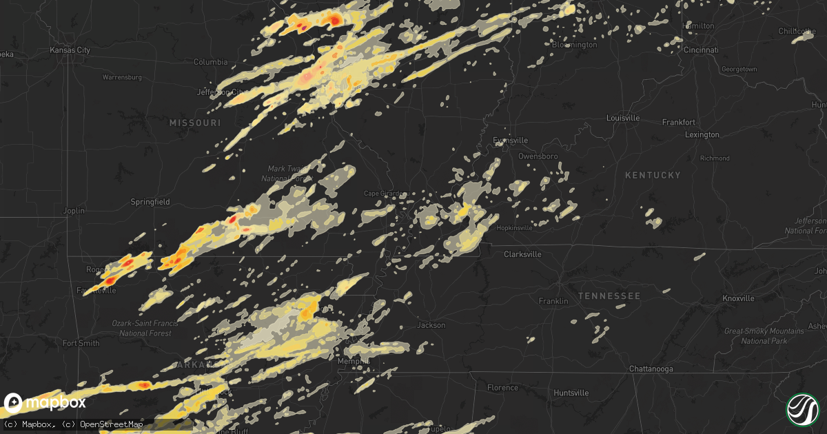
Hail Map in Kentucky on April 19, 2011
Get this storm
April 19 map
$229
one time, instant access
Download today. No call, no setup
Keep the $229
Bought the map and want the full workflow? Apply the entire $229 to a subscription within 7 days. None of it is wasted.
Every map, not just this one
This buys you this map. Subscription and you get every map we run, in the markets you choose from a few cities to whole states to nationwide. Plus real-time alerts the moment a storm fires.
Contact data
Name, contact info, occupancy, even credit band for addresses in the footprint. You go from where it hit to who to call.
Become the source they trust
Unlimited branding weather history reports on demand. You already have the documented answer ready for the property owner, and you are the one who showed up with it.
Property data and RoofTrace estimates
Pull up any address you have got, its value and the exact code rules for that jurisdiction, straight from One Click Code. Then RoofTrace estimates the squares, pitch, and roof value, priced the way you price.
Storm reports in Kentucky
Kentucky
| Date | Description |
|---|---|
| 04/19/20113:05 AM CDT | 2 trees blown down along williamsburg st |
| 04/19/20112:42 AM CDT | Trees down. |
| 04/19/20112:25 AM CDT | Quarter sized hail reported in milltown...just west of columbia. Multiple trees down and power outages in columbia. |
| 04/19/20112:22 AM CDT | Structural damage from straight line winds. Section of roof blown off apartment building. Damage to cars reported |
| 04/19/20112:15 AM CDT | Trees down. |
| 04/19/20112:10 AM CDT | Trees down along county park road off of hwy 460 |
| 04/19/20112:00 AM CDT | A local report indicates 1.00 inch wind near 6 W GREENSBURG |
| 04/19/20112:00 AM CDT | Small outbuilding was blown over near the community christian church |
| 04/19/20111:59 AM CDT | Event occured at triangle mtn raws station between about 255 and 302 a.m. |
| 04/19/20111:57 AM CDT | Trees down on homes in the southern part of the county. |
| 04/19/20111:52 AM CDT | Trees were reported down across southern allen county. A tree was blocking the road at the 800 block of holland road. A downed trees also blocked the intersections of w |
| 04/19/20111:50 AM CDT | Trees and power lines down county wide. A tree was blocking cherry street in the town of glasgow. |
| 04/19/20111:50 AM CDT | A local report indicates 69 MPH wind near GLASGOW |
| 04/19/20111:49 AM CDT | A local report indicates 70 MPH wind near 5 NW IRVINE |
| 04/19/20111:45 AM CDT | A local report indicates 1.00 inch wind near BOWLING GREEN |
| 04/19/20111:43 AM CDT | A local report indicates 1.00 inch wind near PLANO |
| 04/19/20111:39 AM CDT | A tree was down on georgetown road. |
| 04/19/20111:38 AM CDT | A tree was downed in berea. Also...power lines also reported downed. |
| 04/19/20111:35 AM CDT | Up to quarter size hail in the memphis junction area. |
| 04/19/20111:35 AM CDT | A local report indicates 58 MPH wind near BYBEE |
| 04/19/20111:35 AM CDT | Trees were down...some on power lines. Power lines down. Trees blocking roads. |
| 04/19/20111:30 AM CDT | A local report indicates 1.00 inch wind near BROWNSVILLE |
| 04/19/20111:30 AM CDT | Tree down near hillsboro |
| 04/19/20111:30 AM CDT | Ef-1 tornado with estimated wind speeds of 90-95 mph. Path length 3.3 miles and width 100 yards. Barn destroyed and debris thrown a quarter mile. Tornado damaged a roof |
| 04/19/20111:30 AM CDT | Several trees down around town. One utility pole leaning. |
| 04/19/20111:30 AM CDT | Trees snapped and downed. |
| 04/19/20111:21 AM CDT | Tree down on highway 431. |
| 04/19/20111:17 AM CDT | Four trees and a power line down. A trampoline was blown into a roadway. |
| 04/19/20111:13 AM CDT | Winds estimated 30 mph with the storm. |
| 04/19/20111:13 AM CDT | Late report. Wind gusts measured 60 to 62 mph. Large trees blocking roads west to east along hwy 94. 1 large tree went through a house 2w of murray along oaks country r |
| 04/19/20111:06 AM CDT | Several trees downed just north of breckinridge. |
| 04/19/20111:05 AM CDT | Light pole down near the north junction of us 27 in nicholasville. Trees down at allen drive. |
| 04/19/20111:04 AM CDT | A tree was down at the intersection of mcdowell and fontaine roads. |
| 04/19/20111:00 AM CDT | Tree down across highway 19. |
| 04/19/201112:58 AM CDT | Tree down across route 22. |
| 04/19/201112:54 AM CDT | Semi trucks blown over |
| 04/19/201112:54 AM CDT | Ef-1 tornado with wind speeds estimated at 90-95 mph. Path length 0.5 miles and width 50 yards. Tied-down trailer overturned. Several outbuildings destroyed or damaged. |
| 04/19/201112:48 AM CDT | Trees down on paris pike and on newtown pike near county fire number 4. |
| 04/19/201112:45 AM CDT | Measured wind gust to 58 mph at fort campbell. Large trees down in nearby oak grove. |
| 04/19/201112:44 AM CDT | Trees down across northwest portion of montgomery county. |
| 04/19/201112:44 AM CDT | Trees down |
| 04/19/201112:40 AM CDT | Late report. 3 sided barn or lean to was blown across a road. Four greenhouses damaged. |
| 04/19/201112:39 AM CDT | Trees down |
| 04/19/201112:38 AM CDT | A local report indicates 60 MPH wind near WILLIAMSTOWN |
| 04/19/201112:32 AM CDT | Estimated 60 mph gust from amateur radio |
| 04/19/201112:30 AM CDT | A local report indicates 60 MPH wind near BROWNSVILLE |
| 04/19/201112:30 AM CDT | Multiple trees downed countywide. Power outages both east and west of frankfort. |
| 04/19/201112:30 AM CDT | A local report indicates 65 MPH wind near COBB |
| 04/19/201112:29 AM CDT | Trees and power lines down in the city |
| 04/19/201112:29 AM CDT | Trees were down on roadways throughout the city. A sign was blown in to a window at a business in the 800 block of louisville road. |
| 04/19/201112:28 AM CDT | Ef-0 tornado with wind speeds estimated at 65-70 mph. Path length 4.7 miles and width 30 yards. Several trees damaged and shingles knocked off of houses. Most intense d |
| 04/19/201112:27 AM CDT | Capital avenue closed by downed tree. |
| 04/19/201112:26 AM CDT | Reported at capital city airport |
| 04/19/201112:25 AM CDT | Roof blown off house |
| 04/19/201112:23 AM CDT | Tree down blocking highway 55. |
| 04/19/201112:15 AM CDT | Large tree limbs down |
| 04/19/201112:15 AM CDT | Possible tornado damage path includes severe structural damage to i-75 nb rest area...semi trucks blown over...4 mobile homes flipped off foundation...roof damage...bar |
| 04/19/201112:15 AM CDT | Four damaged barns...one destroyed barn...lots of trees down. Estimated 95 to 100 mph winds. |
| 04/19/201112:15 AM CDT | Damage survey indicated straight line winds of 80 to 120 mph. Structural damage to i-75 nb rest area...semi trucks blown over...3 mobile homes moved off foundation...ro |
| 04/19/201112:15 AM CDT | Structural and tree damage. Estimated 100 mph winds. |
| 04/19/201112:15 AM CDT | A local report indicates 60 MPH wind near CARROLLTON |
| 04/19/201112:10 AM CDT | A newly constructed metal garage workbuilding was destroyed. |
| 04/19/201112:06 AM CDT | Trees down in the city |
| 04/19/201112:05 AM CDT | Trees and power lines down |
| 04/19/201112:04 AM CDT | A local report indicates 60 MPH wind near SIMPSONVILLE |
| 04/18/201111:52 PM CDT | Trees and power lines down |
| 04/18/201111:51 PM CDT | Trees down |
| 04/18/201111:50 PM CDT | Straight-line wind damage...winds estimated at 60-70 mph. Mainly tree damage with some power lines down. |
| 04/18/201111:50 PM CDT | A local report indicates 1.00 inch wind near COBB |
| 04/18/201111:49 PM CDT | Ef-1 tornado with winds estimated at 90 mph. Path length 0.2 miles and width 80 yards. Barn destroyed and large hardwood trees snapped 30 feet off the ground. It later |
| 04/18/201111:49 PM CDT | Numerous trees down |
| 04/18/201111:46 PM CDT | Straight-line wind damage...winds estimated at 60-70 mph. Mainly tree damage with some power lines down. |
| 04/18/201111:44 PM CDT | A local report indicates 60 MPH wind near LEITCHFIELD |
| 04/18/201111:39 PM CDT | Power line flashes reported |
| 04/18/201111:39 PM CDT | A local report indicates 60 MPH wind near BROOKS |
| 04/18/201111:37 PM CDT | Damage to a home on sirocco road...roof blown off...carport damaged...above ground pool damaged. |
| 04/18/201111:35 PM CDT | Roof off a house on new highland church road. |
| 04/18/201111:32 PM CDT | Dime size hail reported with storm. |
| 04/18/201111:30 PM CDT | The city of louisville reports numerous trees down throughout the metro area. |
| 04/18/201111:30 PM CDT | Trees down countywide. |
| 04/18/201111:29 PM CDT | Power line flashes reported |
| 04/18/201111:24 PM CDT | Trees and power lines down |
| 04/18/201111:21 PM CDT | Trees and power lines down |
| 04/18/201111:17 PM CDT | Trees reported down |
| 04/18/201111:17 PM CDT | Trees down across highway 333 |
| 04/18/201111:15 PM CDT | Tree down and siding blown off house near fincastl area. |
| 04/18/201111:15 PM CDT | A local report indicates 1.75 inch wind near CALVERT CITY |
| 04/18/201111:14 PM CDT | A local report indicates 59 MPH wind near DEANEFIELD |
| 04/18/201111:12 PM CDT | Trees and power lines down |
| 04/18/201111:11 PM CDT | Late report. Winds estimated 60 to 70 mph. |
| 04/18/201111:10 PM CDT | A local report indicates 66 MPH wind near MARION |
| 04/18/201111:07 PM CDT | Trees down west of the city |
| 04/18/201111:03 PM CDT | A local report indicates 66 MPH wind near LEWISPORT |
| 04/18/201110:54 PM CDT | Ef-o tornado with wind speeds estimated at 65-80 mph. Tornado lifted in several locations along the 11 mile path...with greatest width at 50 yards. The tornado continue |
| 04/18/201110:43 PM CDT | Pea size hail reported with storm. |
| 04/18/201110:43 PM CDT | Trees reported down. |
| 04/18/201110:38 PM CDT | Damage to a few garage buildings along highway 121. Storm producing marble size hail. |
| 04/18/201110:27 PM CDT | On the east side of the city |
| 04/18/201110:27 PM CDT | Reported at barkley regional airport. |
| 04/18/201110:05 PM CDT | On the east side of the city |
| 04/18/201110:02 PM CDT | Reported along highway 41. |
All States Impacted by Hail Map on April 19, 2011
Cities Impacted by Hail Map on April 19, 2011
- Eldred, IL
- Carrollton, IL
- Henning, TN
- Ripley, TN
- Olive Branch, MS
- Byhalia, MS
- Hernando, MS
- Marshall, AR
- Leslie, AR
- Carthage, AR
- Chardon, OH
- Montville, OH
- Pomona, MO
- Willow Springs, MO
- Haworth, OK
- Foreman, AR
- Roodhouse, IL
- White Hall, IL
- Hillview, IL
- Patterson, IL
- Greenfield, IL
- Annapolis, MO
- Des Arc, MO
- Holcomb, MS
- Scobey, MS
- Grenada, MS
- Coffeeville, MS
- Cascilla, MS
- Sturgis, MS
- Ackerman, MS
- Maben, MS
- Starkville, MS
- Mathiston, MS
- Orlando, FL
- Bauxite, AR
- Bryant, AR
- Benton, AR
- Jacksonville, AR
- North Little Rock, AR
- Sherwood, AR
- Scott, AR
- Lonsdale, AR
- Little Rock, AR
- Mabelvale, AR
- Alexander, AR
- Traskwood, AR
- Carlinville, IL
- Modesto, IL
- Hettick, IL
- Waverly, IL
- Virden, IL
- Girard, IL
- Franklin, IL
- Palmyra, IL
- East Carondelet, IL
- Columbia, IL
- Glen Carbon, IL
- Edwardsville, IL
- Collinsville, IL
- Saint Jacob, IL
- East Saint Louis, IL
- Troy, IL
- Dupo, IL
- Millstadt, IL
- Saint Louis, MO
- Granite City, IL
- Maryville, IL
- Caseyville, IL
- Madison, IL
- Hooks, TX
- New Boston, TX
- Gilson, IL
- Dahinda, IL
- Williamsfield, IL
- Atoka, OK
- Coalgate, OK
- Talihina, OK
- Honobia, OK
- Nashoba, OK
- Jonesboro, AR
- Eldon, IA
- Shawneetown, IL
- Ridgway, IL
- Junction, IL
- Hampton, AR
- New Haven, IN
- Woodburn, IN
- Arlington, TX
- Bedford, TX
- Euless, TX
- North Richland Hills, TX
- Hurst, TX
- Fort Worth, TX
- Martinsville, IL
- Dennison, IL
- Marshall, IL
- Casey, IL
- Kansas, IL
- Paris, IL
- West Terre Haute, IN
- Westfield, IL
- Warrenton, MO
- Marquand, MO
- Fredericktown, MO
- Hampton, KY
- Marion, KY
- Salem, KY
- Colt, AR
- McCrory, AR
- Cotton Plant, AR
- New Haven, MO
- Chamois, MO
- Freeburg, MO
- Westphalia, MO
- Berger, MO
- Hermann, MO
- Loose Creek, MO
- Linn, MO
- Morrison, MO
- Bonnots Mill, MO
- Eureka Springs, AR
- Huntsville, AR
- Berryville, AR
- Frankford, MO
- Curryville, MO
- Bowling Green, MO
- Spencer, IN
- Bowling Green, IN
- Crawfordsville, IN
- Stringtown, OK
- Comstock Park, MI
- Gates Mills, OH
- Cleveland, OH
- Lancaster, OH
- Sugar Grove, OH
- Bremen, OH
- Hopkinsville, KY
- Crofton, KY
- Millport, AL
- Kennedy, AL
- Vernon, AL
- Morgantown, KY
- Lewisburg, KY
- West Alexandria, OH
- Camden, OH
- Martin, TN
- Dresden, TN
- Bennington, OK
- Boswell, OK
- Arcadia, FL
- Trumann, AR
- Harrisburg, AR
- Marked Tree, AR
- Alligator, MS
- Duncan, MS
- Clarksdale, MS
- Ashdown, AR
- Wilton, AR
- Dierks, AR
- Richfield, OH
- Hinckley, OH
- Medina, OH
- New Florence, MO
- Eureka, MO
- House Springs, MO
- State University, AR
- Grapevine, TX
- Southlake, TX
- Dixon, MO
- Devils Elbow, MO
- Rolla, MO
- Vichy, MO
- Saint James, MO
- Newburg, MO
- Jerome, MO
- Hartford, KY
- Cadiz, KY
- Rosebud, MO
- Gerald, MO
- Harrell, AR
- Alvarado, TX
- Keene, TX
- Godley, TX
- Joshua, TX
- Cleburne, TX
- Burleson, TX
- Grandview, TX
- Hillsboro, TX
- Covington, TX
- Itasca, TX
- Milford, TX
- Mountain View, MO
- Saint Joseph, IL
- Section, AL
- Mason, TN
- Arlington, TN
- Gibson City, IL
- Foosland, IL
- Rogers, AR
- Elkton, KY
- Sharon Grove, KY
- Black Rock, AR
- Caledonia, MS
- Philipp, MS
- Minter City, MS
- Pulaski, IL
- Olmsted, IL
- Villa Ridge, IL
- Knobel, AR
- Corning, AR
- Marvell, AR
- Lexa, AR
- Poplar Grove, AR
- Lakeland, FL
- Plant City, FL
- Terre Haute, IN
- Rosedale, IN
- Higginson, AR
- Clarksville, TX
- Bowling Green, KY
- Wappapello, MO
- McGee, MO
- Pleasant Plains, AR
- Bradford, AR
- Camden, AR
- Pontotoc, MS
- Shannon, MS
- Wolfe City, TX
- Ladonia, TX
- Golden Eagle, IL
- Brussels, IL
- Saint Charles, MO
- O'Fallon, MO
- Hot Springs National Park, AR
- Bismarck, AR
- Gillespie, IL
- Raymond, IL
- Fieldon, IL
- Earth City, MO
- Cedar Hill, MO
- Pocahontas, IL
- Winchester, IL
- Elsah, IL
- Pearl, IL
- Greenville, IL
- Piasa, IL
- Altamont, IL
- Grafton, IL
- Loami, IL
- Alton, IL
- Valmeyer, IL
- Hillsboro, IL
- Pleasant Hill, IL
- Bingham, IL
- New Douglas, IL
- Litchfield, IL
- Mount Olive, IL
- West Alton, MO
- Rockport, IL
- Stewardson, IL
- Bland, MO
- Saint Peters, MO
- Valley Park, MO
- O'Fallon, IL
- Wright City, MO
- Clarksville, MO
- Shipman, IL
- Fenton, MO
- Ballwin, MO
- Florissant, MO
- Catawissa, MO
- Alexander, IL
- Hamel, IL
- Saint Clair, MO
- Mulberry Grove, IL
- Neoga, IL
- Beecher City, IL
- Nebo, IL
- Fairview Heights, IL
- Imperial, MO
- Portage Des Sioux, MO
- Bethalto, IL
- Saint Ann, MO
- Trilla, IL
- Brownstown, IL
- Godfrey, IL
- Murrayville, IL
- Coffeen, IL
- Owensville, MO
- High Ridge, MO
- Brighton, IL
- Taylor Springs, IL
- Panama, IL
- Augusta, MO
- Beaufort, MO
- Lerna, IL
- Maryland Heights, MO
- Hartford, IL
- Jefferson City, MO
- Donnellson, IL
- Effingham, IL
- Leslie, MO
- Marine, IL
- Dow, IL
- Worden, IL
- Pacific, MO
- Alhambra, IL
- Union, MO
- Jerseyville, IL
- Wildwood, MO
- Hazelwood, MO
- Dittmer, MO
- Bunker Hill, IL
- Fidelity, IL
- Cowden, IL
- Lake Saint Louis, MO
- Medora, IL
- Staunton, IL
- Defiance, MO
- Bridgeton, MO
- Chesterfield, IL
- Dorsey, IL
- Jacksonville, IL
- Toledo, IL
- Belleville, IL
- Foristell, MO
- Roxana, IL
- Lonedell, MO
- Lebanon, IL
- Fillmore, IL
- Livingston, IL
- Sigel, IL
- Old Monroe, MO
- Chesterfield, MO
- Shumway, IL
- Robertsville, MO
- Pittsfield, IL
- Moro, IL
- Waggoner, IL
- Wentzville, MO
- Highland, IL
- Sorento, IL
- Kane, IL
- Cottage Hills, IL
- Walshville, IL
- Washington, MO
- East Alton, IL
- Belle, MO
- Marthasville, MO
- Louisiana, MO
- Arnold, MO
- Ramsey, IL
- Wood River, IL
- Nilwood, IL
- Kampsville, IL
- Thebes, IL
- Benton, MO
- Advance, MO
- Oran, MO
- Bell City, MO
- Scott City, MO
- Madisonville, KY
- Sacramento, KY
- Vernon, IL
- Kinmundy, IL
- Alma, IL
- Patoka, IL
- Lead Hill, AR
- Harrison, AR
- Lane, OK
- Saint Augustine, IL
- Avon, IL
- Decatur, IL
- Oreana, IL
- Calhoun City, MS
- Frisco, TX
- Little Elm, TX
- Rushville, IL
- Mount Sterling, IL
- Frederick, IL
- Wellsville, MO
- Vandalia, MO
- Middletown, MO
- Vilonia, AR
- Romance, AR
- Enola, AR
- Mount Vernon, AR
- Denton, TX
- Pine Bluff, AR
- Rison, AR
- Houston, MS
- Mayflower, AR
- Squires, MO
- Wasola, MO
- Noble, MO
- Ava, MO
- Powderly, TX
- Dekalb, IL
- Painesville, OH
- Saint Louisville, OH
- Utica, OH
- Quitman, AR
- Aberdeen, MS
- Okolona, MS
- McCarley, MS
- Duck Hill, MS
- Avery, TX
- Annona, TX
- De Kalb, TX
- Jewett, IL
- Farina, IL
- Hidalgo, IL
- Mason, IL
- Wheeler, IL
- Carlyle, IL
- Dieterich, IL
- Vandalia, IL
- Saint Peter, IL
- Greenup, IL
- West Union, IL
- Yale, IL
- Montrose, IL
- Newton, IL
- Watson, IL
- Edgewood, IL
- Shobonier, IL
- Inverness, MS
- Belzoni, MS
- Greenville, MS
- Isola, MS
- Leland, MS
- Hollandale, MS
- Indianola, MS
- Violet Hill, AR
- Franklin, AR
- Saint Michael, PA
- Sidman, PA
- Claysburg, PA
- Johnstown, PA
- Portage, PA
- Beaverdale, PA
- South Fork, PA
- Summerhill, PA
- East Freedom, PA
- Salix, PA
- Roaring Spring, PA
- Sherman, TX
- Tamms, IL
- Ullin, IL
- Lockesburg, AR
- Clayton, IL
- Timewell, IL
- Camden, IL
- Guilford, IN
- Sunman, IN
- Lawrenceburg, IN
- Harrison, OH
- West Harrison, IN
- Morganfield, KY
- Waverly, KY
- Muse, OK
- Smithville, OK
- Whitesboro, OK
- Hodgen, OK
- Grand Rivers, KY
- Calvert City, KY
- Brighton, IA
- Lockridge, IA
- Mount Pleasant, IA
- Fairfield, IA
- Wayland, IA
- Paris, MS
- Water Valley, MS
- Oxford, MS
- Crowley, TX
- Waterloo, IL
- White Hall, AR
- Springdale, AR
- Fayetteville, AR
- Hindsville, AR
- Peel, AR
- Yellville, AR
- Northbrook, IL
- Peoria, IL
- East Peoria, IL
- Creve Coeur, IL
- Somerville, TN
- Rushville, IN
- Brookville, IN
- Laurel, IN
- Oldenburg, IN
- Greensburg, IN
- Metamora, IN
- New Madrid, MO
- Catron, MO
- Matthews, MO
- Bertrand, MO
- East Prairie, MO
- Brownsville, TN
- Tillar, AR
- Evansville, IN
- Centertown, KY
- Sinclairville, NY
- Fort Leonard Wood, MO
- Dexter, KY
- Almo, KY
- Murray, KY
- Palestine, AR
- Roland, AR
- Silva, MO
- Malvern, AR
- Blue Eye, MO
- Lampe, MO
- Rome, OH
- Orwell, OH
- Russellville, KY
- Friendship, TN
- Trenton, TN
- Halls, TN
- Dyersburg, TN
- Montverde, FL
- Salem, MO
- Divernon, IL
- Dover, OH
- New Philadelphia, OH
- Bismarck, IL
- Danville, IL
- Oakwood, IL
- Hendrix, OK
- Savoy, TX
- Bells, TX
- Ravenna, TX
- Denison, TX
- Londonderry, OH
- Chillicothe, OH
- Elizabethtown, IL
- Joiner, AR
- Batesville, AR
- Floral, AR
- Kensett, AR
- Searcy, AR
- Judsonia, AR
- Casa, AR
- Kennett, MO
- Hornersville, MO
- Cardwell, MO
- Senath, MO
- Arbyrd, MO
- Heavener, OK
- Mena, AR
- Morgantown, IN
- Ravenden, AR
- Ravenden Springs, AR
- Waynesville, MO
- La Center, KY
- Obion, TN
- Hornbeak, TN
- Lake Village, AR
- Argyle, TX
- Ponder, TX
- Justin, TX
- Krum, TX
- Arkadelphia, AR
- Fulton, AR
- Stephens, AR
- Leola, AR
- Ivanhoe, TX
- Gurdon, AR
- Washington, AR
- Arthur City, TX
- Thornton, AR
- Rosston, AR
- Fordyce, AR
- Paris, TX
- Mineral Springs, AR
- Friendship, AR
- Bluff City, AR
- Chidester, AR
- Emmet, AR
- Sheridan, AR
- Idabel, OK
- Okolona, AR
- Winthrop, AR
- Jersey, AR
- Donaldson, AR
- De Queen, AR
- Amity, AR
- Howe, TX
- Bonham, TX
- Kingsland, AR
- Detroit, TX
- Delight, AR
- Banks, AR
- Sumner, TX
- Eagletown, OK
- Sparkman, AR
- Hope, AR
- Alleene, AR
- Saratoga, AR
- Horatio, AR
- Honey Grove, TX
- Bagwell, TX
- Brookston, TX
- Murfreesboro, AR
- Poyen, AR
- Prescott, AR
- Antoine, AR
- Bearden, AR
- Warren, AR
- Telephone, TX
- Blevins, AR
- Nashville, AR
- New Edinburg, AR
- Blossom, TX
- McCaskill, AR
- Granbury, TX
- Rio Vista, TX
- Vardaman, MS
- Pittsboro, MS
- Houlka, MS
- Jefferson, OH
- Ashtabula, OH
- Munroe Falls, OH
- Akron, OH
- Tallmadge, OH
- Stow, OH
- Kent, OH
- Oak Brook, IL
- Dallas, TX
- Pangburn, AR
- Lowell, AR
- Tremont, MS
- Colleyville, TX
- Gilbertsville, KY
- Hickory Ridge, AR
- Cherry Valley, AR
- Wynne, AR
- Argenta, IL
- Cisco, IL
- Norman, AR
- Mount Ida, AR
- Mt Zion, IL
- Dalton City, IL
- Dudley, MO
- Dexter, MO
- Schlater, MS
- West Plains, MO
- Birch Tree, MO
- Peace Valley, MO
- Princeton, KY
- Eddyville, KY
- Springfield, AR
- Greenbrier, AR
- Damascus, AR
- Lewisville, TX
- The Colony, TX
- Camp, AR
- Glencoe, AR
- Quincy, IN
- Stilesville, IN
- Monrovia, IN
- Cloverdale, IN
- Clayton, IN
- Greencastle, IN
- Fillmore, IN
- Coatesville, IN
- Martinsville, IN
- Shelbyville, IN
- Alpena, AR
- Green Forest, AR
- Oconee, IL
- Grapevine, AR
- Princeville, IL
- Dunlap, IL
- Edelstein, IL
- Speer, IL
- Plainview, AR
- Moores Hill, IN
- Milan, IN
- Aurora, IN
- Ellsinore, MO
- Grandin, MO
- Williamsville, MO
- Poplar Bluff, MO
- Saint David, IL
- Bryant, IL
- Elmwood, IL
- Hanna City, IL
- Cuba, IL
- Canton, IL
- Glasford, IL
- Wyoming, IL
- Trivoli, IL
- Farmington, IL
- Norris, IL
- Sparland, IL
- Lewistown, IL
- Brimfield, IL
- Mapleton, IL
- Falconer, NY
- Kennedy, NY
- Duke, MO
- Bradyville, TN
- Morrison, TN
- Klondike, TX
- Sulphur Springs, TX
- Cooper, TX
- Commerce, TX
- Dike, TX
- Pecan Gap, TX
- Colbert, OK
- Monroeville, IN
- Roann, IN
- Denver, IN
- Macy, IN
- Pollard, AR
- Piggott, AR
- Manchester, TN
- Wartrace, TN
- Beechgrove, TN
- De Soto, MO
- Brickeys, AR
- Marianna, AR
- Smithland, KY
- Tiline, KY
- Commerce Township, MI
- White Lake, MI
- Prairie Grove, AR
- Golden, MO
- Hollister, MO
- Elkins, AR
- Garfield, AR
- Oak Grove, AR
- Eagle Rock, MO
- Shell Knob, MO
- Farmington, AR
- Ridgedale, MO
- Omaha, AR
- Patton, MO
- Perryville, MO
- Waldron, AR
- Protem, MO
- Gosport, IN
- Bloomington, IN
- Ellettsville, IN
- Houston, MO
- Eudora, AR
- Itta Bena, MS
- Moorhead, MS
- Piedmont, MO
- Van Buren, MO
- Swifton, AR
- Tuckerman, AR
- Parthenon, AR
- Jasper, AR
- Deer, AR
- Hasty, AR
- Vendor, AR
- Benton, KY
- Ingraham, IL
- Tyronza, AR
- Wilmar, AR
- Pearcy, AR
- Tucker, AR
- Moyers, OK
- Hunter, AR
- Letona, AR
- Desha, AR
- Star City, AR
- Amagon, AR
- Walnut Ridge, AR
- Gilmore, AR
- Heber Springs, AR
- Alicia, AR
- Oil Trough, AR
- Beebe, AR
- Bald Knob, AR
- Burlison, TN
- Des Arc, AR
- Newark, AR
- Cartwright, OK
- Newhope, AR
- Clayton, OK
- Bokchito, OK
- Hot Springs Village, AR
- Wabbaseka, AR
- Fairfield Bay, AR
- Sherrill, AR
- Harvey, AR
- Paron, AR
- England, AR
- De Valls Bluff, AR
- Crawfordsville, AR
- Fisher, AR
- Rosie, AR
- Russell, AR
- Hensley, AR
- Snow, OK
- Brookland, AR
- Whitewright, TX
- El Paso, AR
- Yorktown, AR
- Ida, AR
- Boles, AR
- Wilson, AR
- Prim, AR
- Altheimer, AR
- Wilburn, AR
- Turrell, AR
- Humnoke, AR
- Griffithville, AR
- Conway, AR
- McRae, AR
- Bee Branch, AR
- Shirley, AR
- Maumelle, AR
- Tumbling Shoals, AR
- Concord, AR
- Prattsville, AR
- Drummonds, TN
- Parks, AR
- Grady, AR
- Augusta, AR
- Little Rock Air Force Base, AR
- Dyess, AR
- Bassett, AR
- Hazen, AR
- Thida, AR
- Parkin, AR
- Antlers, OK
- Earle, AR
- Austin, AR
- Sulphur Rock, AR
- Ozan, AR
- Wapanucka, OK
- Mountain View, AR
- Weiner, AR
- Rattan, OK
- Charlotte, AR
- Edgemont, AR
- Bono, AR
- Lepanto, AR
- Gillham, AR
- Osceola, AR
- Ulm, AR
- Stuttgart, AR
- Garner, AR
- Locust Grove, AR
- Umpire, AR
- Frenchmans Bayou, AR
- Albion, OK
- Rose Bud, AR
- Hermitage, AR
- Bigelow, AR
- Drasco, AR
- Calera, OK
- Magness, AR
- Brighton, TN
- Redfield, AR
- Carlisle, AR
- Beedeville, AR
- Perryville, AR
- Booneville, AR
- Newport, AR
- Daisy, OK
- Marcella, AR
- Higden, AR
- Jefferson, AR
- Roe, AR
- Durant, OK
- Tupelo, OK
- Kirby, AR
- Paragould, AR
- Cabot, AR
- Cord, AR
- Cash, AR
- Columbia, KY
- Springfield, IL
- Sherman, IL
- Elkhart, IL
- Lincoln, IL
- Middletown, IL
- Richland, MO
- Westport, IN
- Hartsville, IN
- Centertown, MO
- Punta Gorda, FL
- Tupelo, MS
- Amory, MS
- Plantersville, MS
- Nettleton, MS
- Fulton, MS
- Smithville, MS
- Sullivan, MO
- Tichnor, AR
- Oakland, TN
- Toulon, IL
- Hickman, KY
- Union City, TN
- Herrick, IL
- Rosamond, IL
- Pana, IL
- Tower Hill, IL
- Nokomis, IL
- Addieville, IL
- Moscow, TN
- Keller, TX
- Irving, TX
- Coppell, TX
- Grand Prairie, TX
- Plano, TX
- Flower Mound, TX
- Carrollton, TX
- Haltom City, TX
- Roanoke, TX
- Moscow Mills, MO
- Troy, MO
- Bourbon, MO
- Lambert, MS
- Cecil, OH
- Saint Francisville, IL
- Ona, FL
- Myakka City, FL
- Dunmor, KY
- Belton, KY
- Rochester, KY
- Woodland, MS
- Prairie, MS
- Wadsworth, OH
- Barberton, OH
- Camp Point, IL
- Equality, IL
- Herod, IL
- Harrisburg, IL
- Rockbridge, IL
- Oneida, TN
- Winfield, TN
- Jamestown, KY
- Eaton, OH
- Montgomery City, MO
- Millington, TN
- Memphis, TN
- Gunnison, MS
- Mellwood, AR
- Snow Lake, AR
- Crumrod, AR
- Gillett, AR
- Benton Harbor, MI
- Hamburg, IL
- Batchtown, IL
- Elsberry, MO
- Morrilton, AR
- Ola, AR
- Brazil, IN
- Rockville, IN
- Laura, IL
- Doddsville, MS
- Thornfield, MO
- Cambridge Springs, PA
- Streetsboro, OH
- Mantua, OH
- Chagrin Falls, OH
- Hudson, OH
- Aurora, OH
- Chippewa Lake, OH
- Seville, OH
- Logansport, IN
- Williamsville, IL
- Campbell, MO
- Doe Run, MO
- Burton, OH
- Corydon, KY
- Mount Carroll, IL
- Howard, OH
- Danville, OH
- Mount Vernon, OH
- Gambier, OH
- Saint Paul, IN
- Flat Rock, IN
- Mansfield, TX
- Blum, TX
- Kennedale, TX
- Mayfield, KY
- Farmington, KY
- Steedman, MO
- Dewittville, NY
- Stockton, NY
- Charleston, IL
- Oakland, IL
- Licking, MO
- Big Creek, MS
- Bruce, MS
- Hillsboro, MO
- Gould, AR
- Brixey, MO
- Gainesville, MO
- Eminence, MO
- Summersville, MO
- Pawnee, IL
- Rochester, IL
- Edinburg, IL
- Blue Springs, MS
- Belden, MS
- Winona, MS
- Stewart, MS
- Kilmichael, MS
- Greenwood, MS
- Carrollton, MS
- Gore Springs, MS
- Eupora, MS
- North Carrollton, MS
- Whitesville, KY
- Fordsville, KY
- Dundee, KY
- Reynolds Station, KY
- Owensboro, KY
- Horse Cave, KY
- Jonesburg, MO
- Truxton, MO
- Hawk Point, MO
- Waterford, MI
- West Bloomfield, MI
- Hennepin, IL
- Hope, IN
- Laquey, MO
- Falcon, MO
- Fayette, AL
- Leesburg, FL
- Mascotte, FL
- Groveland, FL
- Allendale, MI
- Jenison, MI
- Marne, MI
- Hudsonville, MI
- Grand Rapids, MI
- Warm Springs, AR
- Couch, MO
- Pocahontas, AR
- Lynnville, TN
- Mount Pleasant, TN
- Summertown, TN
- Bedford, OH
- Twinsburg, OH
- Solon, OH
- Northfield, OH
- Macedonia, OH
- Peninsula, OH
- Brecksville, OH
- Bradford, IL
- Freedom, IN
- Worthington, IN
- Scott Air Force Base, IL
- Mascoutah, IL
- Clubb, MO
- Arcadia, MO
- Greenville, MO
- Hamilton, MS
- Cunningham, KY
- Kevil, KY
- Wickliffe, KY
- Paducah, KY
- West Paducah, KY
- Melber, KY
- Bardwell, KY
- Alton, MO
- Columbia Station, OH
- Olmsted Falls, OH
- Lonoke, AR
- Winona, MO
- Fremont, MO
- Theodosia, MO
- Richwoods, MO
- Leasburg, MO
- Fredonia, KY
- Rector, AR
- Waverly, OH
- Wilsonville, IL
- Benld, IL
- Waveland, IN
- Dermott, AR
- Arcadia, IN
- Cicero, IN
- Ellisville, IL
- Vina, AL
- Golden, MS
- Knox, IN
- Culver, IN
- Columbus Junction, IA
- Winfield, IA
- Wapello, IA
- Morning Sun, IA
- Tillatoba, MS
- Coila, MS
- Ashmore, IL
- Oblong, IL
- Willow Hill, IL
- Texarkana, TX
- Atlanta, IN
- Garland, TX
- Addison, TX
- Richardson, TX
- Elgin, IL
- Hoffman Estates, IL
- Clay, KY
- Moody, MO
- Foley, MO
- Winfield, MO
- Ellington, MO
- Sawyerville, IL
- Cape Fair, MO
- Galena, MO
- Reeds Spring, MO
- Waynetown, IN
- Dayton, OH
- Bolivar, TN
- Batavia, IA
- Libertyville, IA
- Attica, IN
- Bainbridge, IN
- Ash Flat, AR
- Forney, TX
- Knoxville, IL
- Maquon, IL
- Pottersville, MO
- Vanzant, MO
- Fairview, IL
- Ipava, IL
- Chillicothe, IL
- Brighton, MI
- Meadville, PA
- Defiance, OH
- Center Ridge, AR
- Vaiden, MS
- Brinkley, AR
- Holly Grove, AR
- Clarendon, AR
- Drury, MO
- Doniphan, MO
- Connersville, IN
- Geneva, OH
- Bragg City, MO
- Mound Bayou, MS
- Auburn, IL
- Thayer, IL
- Thayer, MO
- Windsor, IL
- Strasburg, IL
- New Berlin, IL
- Pleasant Plains, IL
- Melbourne, AR
- Arthur, IL
- Arcola, IL
- Hardin, KY
- Geneva, IL
- Saint Charles, IL
- Elburn, IL
- Madison, OH
- Perry, OH
- Centerville, MO
- Conneautville, PA
- Saegertown, PA
- Bridgeport, IL
- Hanson, KY
- Earlington, KY
- Island, KY
- Manitou, KY
- Sturdivant, MO
- Zalma, MO
- Puxico, MO
- Timbo, AR
- Onia, AR
- Vermont, IL
- La Fayette, IL
- Galva, IL
- Victoria, IL
- Altona, IL
- Cherokee Village, AR
- Hardy, AR
- New Lebanon, OH
- Vance, MS
- Angola, NY
- Irving, NY
- New London, MO
- Fisk, MO
- Holland, NY
- Franklin Park, IL
- Bensenville, IL
- Wood Dale, IL
- Winnetka, IL
- Niles, IL
- Park Ridge, IL
- Wilmette, IL
- Des Plaines, IL
- Morton Grove, IL
- Glenview, IL
- Golf, IL
- Kenilworth, IL
- Fredericktown, OH
- Oakland, AR
- Norwood, MO
- Pontiac, MO
- Zanoni, MO
- Dora, MO
- Isabella, MO
- Cedarcreek, MO
- Caulfield, MO
- Tecumseh, MO
- Whiteville, TN
- Mentor, OH
- Rockwall, TX
- Royse City, TX
- Troy, TN
- Casscoe, AR
- De Witt, AR
- Vulcan, MO
- Mount Pleasant, AR
- Guion, AR
- Unionville, IA
- East Aurora, NY
- Tutwiler, MS
- Enid, MS
- Batesville, MS
- Aubrey, AR
- Monroe, MI
- Dundee, MI
- Fort Wayne, IN
- Carbon, IN
- West College Corner, IN
- Liberty, IN
- Metropolis, IL
- Belknap, IL
- Saint Joe, AR
- Marble Falls, AR
- Western Grove, AR
- Ponca, AR
- Everton, AR
- Springfield, OH
- New Ross, IN
- Ladoga, IN
- Caraway, AR
- Rhineland, MO
- Hartsburg, MO
- Fulton, MO
- High Hill, MO
- Williamsburg, MO
- Mokane, MO
- Tebbetts, MO
- Holts Summit, MO
- Portland, MO
- New Bloomfield, MO
- Cabool, MO
- Cerro Gordo, IL
- Somerset, OH
- Junction City, OH
- Kinderhook, IL
- Bartow, FL
- Mooresville, IN
- Plainfield, IN
- Chandlerville, IL
- Humphrey, AR
- Spruce Pine, AL
- Hodges, AL
- Phil Campbell, AL
- Centrahoma, OK
- Winter Garden, FL
- Petersburg, MI
- Riga, MI
- Deerfield, MI
- Blissfield, MI
- Riley, IN
- Hazel, KY
- Sturgis, KY
- Leslie, MI
- Onondaga, MI
- Andover, OH
- Gays, IL
- Mattoon, IL
- Golconda, IL
- Whiteland, IN
- Bargersville, IN
- Franklin, IN
- Brookport, IL
- Boaz, KY
- Barlow, KY
- Fancy Farm, KY
- Hickory, KY
- Watson, AR
- Toone, TN
- Morrisonville, IL
- Eldorado, IL
- Clinton, KY
- Sidney, AR
- Smithville, TN
- Mcminnville, TN
- Patterson, MO
- Barry, IL
- Hull, IL
- Bridgeton, IN
- New Concord, KY
- Cottage Grove, TN
- Palmersville, TN
- Burna, KY
- Kuttawa, KY
- Providence, KY
- Ledbetter, KY
- Kirksey, KY
- Dukedom, TN
- Symsonia, KY
- Puryear, TN
- Sedalia, KY
- Koshkonong, MO
- Monticello, AR
- Lovington, IL
- Shelby, MS
- Coloma, MI
- Watervliet, MI
- Rensselaer, IN
- Greenville, KY
- Chadwick, MO
- Steens, MS
- Bethany, IL
- Mounds, IL
- Butler, OH
- Auburn, KY
- Noblesville, IN
- Saint Joseph, MI
- La Fontaine, IN
- Marion, IN
- Fifty Six, AR
- Tilly, AR
- Jerusalem, AR
- Hector, AR
- Dennard, AR
- Zeeland, MI
- Smithville, AR
- Strawberry, AR
- Bliss, NY
- Brooklyn, MI
- Manchester, MI
- Cherry Creek, NY
- Onarga, IL
- Gilman, IL
- Crescent City, IL
- Chaffee, MO
- Holly Springs, MS
- Lamar, MS
- Rossville, TN
- Red Banks, MS
- Lawtons, NY
- North Collins, NY
- Sainte Genevieve, MO
- Farmington, MO
- Bonne Terre, MO
- Lake City, AR
- Monette, AR
- Leachville, AR
- Columbus, MS
- Gray Summit, MO
- Villa Ridge, MO
- Erie, PA
- Arlington, IL
- Macon, IL
- Steelville, MO
- Adona, AR
- Industry, IL
- Eads, TN
- Marion, AR
- Rueter, MO
- Sidney, IL
- Ogden, IL
- Philo, IL
- Homer, IL
- Moro, AR
- Southaven, MS
- Nesbit, MS
- Cincinnati, OH
- Alamo, TN
- Arlington Heights, IL
- Prospect Heights, IL
- Wheeling, IL
- Mount Prospect, IL
- Rock Creek, OH
- Thompson, OH
- Aubrey, TX
- Sanger, TX
- Sugar Grove, IL
- Riverton, IL
- Dawson, IL
- Buffalo, IL
- Jeffersonville, OH
- Middlefield, OH
- Charleston, MO
- Sachse, TX
- Duncanville, TX
- Mesquite, TX
- Rowlett, TX
- Terrell, TX
- Balch Springs, TX
- Wylie, TX
- Loudonville, OH
- Covington, IN
- Westville, IL
- Williamsport, IN
- Tilton, IL
- Lehigh Acres, FL
- Kingman, IN
- Hillsboro, IN
- Wingate, IN
- New Richmond, IN
- Veedersburg, IN
- Bloomfield, MO
- Sikeston, MO
- Essex, MO
- Belleview, MO
- Ironton, MO
- Lesterville, MO
- Woodville, AL
- Hoyleton, IL
- Centralia, IL
- Okawville, IL
- Nashville, IL
- Hoffman, IL
- Redford, MO
- Hardenville, MO
- Bunker, MO
- Black, MO
- Elk Creek, MO
- Bismarck, MO
- Middle Brook, MO
- Mill Spring, MO
- Park Hills, MO
- Dumas, AR
- Quincy, MI
- Tekonsha, MI
- Homer, MI
- Manila, AR
- Pavilion, NY
- Cypress, IL
- Bay, AR
- Umatilla, FL
- Wheatfield, IN
- Cayuga, IN
- Linden, IN
- Perrysville, IN
- Colfax, IN
- Darlington, IN
- Nebo, KY
- Dawson Springs, KY
- Etowah, AR
- Beulah, MS
- Benoit, MS
- Wideman, AR
- Oxford, AR
- Portland, AR
- Parkdale, AR
- Bowerston, OH
- Catlin, IL
- Fairmount, IL
- College Corner, OH
- Manilla, IN
- French Camp, MS
- New Hope, AL
- Monon, IN
- Beaver Dam, KY
- Olaton, KY
- Rosine, KY
- Horse Branch, KY
- Clinton, AR
- Illiopolis, IL
- Success, MO
- Oakland, MS
- Xenia, OH
- Alpha, OH
- Bellbrook, OH
- Hamilton, AL
- North East, PA
- Lewisburg, OH
- Mount Pulaski, IL
- Hamburg, NY
- Orchard Park, NY
- Peru, IN
- Aurora, IL
- North Aurora, IL
- Astoria, IL
- Colchester, IL
- Henry, IL
- Smithfield, IL
- Table Grove, IL
- Adair, IL
- Macomb, IL
- Plymouth, IL
- Edwards, IL
- Black Oak, AR
- Eugene, MO
- Henley, MO
- Cave In Rock, IL
- Champaign, IL
- Savoy, IL
- Tolono, IL
- Bloomfield, IA
- Freeburg, IL
- Novelty, OH
- Chesterland, OH
- Moweaqua, IL
- Tuscola, IL
- Humboldt, IL
- Sullivan, IL
- Poland, IN
- Edinburgh, IN
- Sandborn, IN
- Huntington, IN
- Andrews, IN
- Wabash, IN
- Rush Hill, MO
- Laddonia, MO
- Bells, TN
- Gadsden, TN
- Derby, NY
- Eden, NY
- Lake Cormorant, MS
- Somerdale, OH
- Mineral City, OH
- Stonington, IL
- Dorset, OH
- Mount Vernon, IN
- Novi, MI
- Northville, MI
- Randolph, MS
- Hoagland, IN
- Crossville, TN
- Uhrichsville, OH
- Tippecanoe, OH
- Scio, OH
- Arlington, KY
- Sandwich, IL
- Somonauk, IL
- Jamestown, OH
- Fountaintown, IN
- Coal City, IN
- Auxvasse, MO
- Ward, AR
- New Haven, IL
- Henderson, TN
- Dellroy, OH
- Carrollton, OH
- Aviston, IL
- Breese, IL
- Rosiclare, IL
- Ethridge, TN
- Paragon, IN
- Johnsonville, IL
- Tiptonville, TN
- Ecru, MS
- Pickens, AR
- New Canton, IL
- Sims, IL
- Guntersville, AL
- Arab, AL
- Centerpoint, IN
- Reelsville, IN
- Amo, IN
- Danville, IN
- Labadie, MO
- Willoughby, OH
- Fulton, KY
- Cambridge, OH
- Maynard, AR
- Pesotum, IL
- Claypool, IN
- Frazeysburg, OH
- Walhonding, OH
- Bath, IL
- Bloomfield, IN
- Silver Lake, IN
- Williford, AR
- Poughkeepsie, AR
- Drakesville, IA
- Brookville, OH
- Saffell, AR
- Wingo, KY
- Water Valley, KY
- Russellville, MO
- Lohman, MO
- Newbury, OH
- Center, MO
- New Hudson, MI
- South Lyon, MI
- Wixom, MI
- Milford, MI
- Havana, IL
- Hamilton, OH
- Coldwater, MS
- Fairland, IN
- Tullahoma, TN
- Smithton, IL
- Allegan, MI
- Grand Junction, MI
- Pullman, MI
- Edinboro, PA
- Kirbyville, MO
- Powersite, MO
- Oneida, IL
- Galesburg, IL
- Lockbourne, OH
- Ashville, OH
- Grand Chain, IL
- Saltillo, MS
- Columbus, IN
- Lyon, MS
- Pope, MS
- Charleston, MS
- Drew, MS
- West Chicago, IL
- Plainfield, IL
- Romeoville, IL
- Bolingbrook, IL
- Twelve Mile, IN
- Crawford, MS
- Medon, TN
- Cordova, TN
- Stanton, TN
- Atoka, TN
- Germantown, TN
- Unionville, TN
- Christiana, TN
- Bell Buckle, TN
- Rockvale, TN
- Thawville, IL
- Roberts, IL
- Loda, IL
- Buckley, IL
- Nortonville, KY
- Chestnutridge, MO
- Winchester, AR
- Celeste, TX
- Rohwer, AR
- Caledonia, NY
- Le Roy, NY
- Fennville, MI
- Falls Of Rough, KY
- Rosedale, MS
- Bement, IL
- Fithian, IL
- Oxford, OH
- Okeana, OH
- Odin, IL
- Sandoval, IL
- Hinckley, IL
- Maple Park, IL
- De Land, IL
- Abingdon, IL
- West, MS
- Greenwood Springs, MS
- Red Bay, AL
- Perrysville, OH
- Collierville, TN
- Prairie Du Rocher, IL
- Forrest City, AR
- Haynes, AR
- Owens Cross Roads, AL
- Brownsboro, AL
- Readyville, TN
- Horton, MI
- Kingston, OK
- Madill, OK
- Delta, OH
- Marshall, IN
- Bloomingdale, IN
- Pilot Point, TX
- Centerville, IN
- Brownsville, IN
- Saint Elmo, IL
- Winfield, IL
- Villa Park, IL
- Lombard, IL
- Glen Ellyn, IL
- Addison, IL
- Wheaton, IL
- Warrenville, IL
- Naperville, IL
- Plano, IL
- Grafton, OH
- Lagrange, OH
- Winamac, IN
- North Judson, IN
- Medaryville, IN
- Antwerp, OH
- Bloomingburg, OH
- Brookston, IN
- Delphi, IN
- Battle Ground, IN
- Saint Thomas, MO
- Woodbury, TN
- Murfreesboro, TN
- Linesville, PA
- Wheatley, AR
- Littleton, IL
- Georgetown, IL
- Indianola, IL
- Allerton, IL
- Sidell, IL
- Ridge Farm, IL
- Smithboro, IL
- Nashville, IN
- Huntsburg, OH
- Harlan, IN
- Gurley, AL
- Wayne, IL
- Roselle, IL
- Elk Grove Village, IL
- Bartlett, IL
- Carol Stream, IL
- Hanover Park, IL
- Schaumburg, IL
- Bloomingdale, IL
- Mammoth Spring, AR
- Horseshoe Bend, AR
- Union City, PA
- Lilbourn, MO
- Portageville, MO
- Marston, MO
- Independence, OH
- Sturkie, AR
- Salem, AR
- Donovan, IL
- Brook, IN
- Kentland, IN
- Sheldon, IL
- Iroquois, IL
- Morocco, IN
- Potosi, MO
- Crocker, MO
- Normandy, TN
- McCool, MS
- Farmington, MI
- Southfield, MI
- Livonia, MI
- Farmersburg, IN
- Parma, MO
- Malden, MO
- Owaneco, IL
- Flippin, AR
- Pittsford, MI
- North Adams, MI
- Munford, TN
- Ethel, MS
- Hutsonville, IL
- Annapolis, IL
- Robinson, IL
- Farber, MO
- Glenwood, AR
- Bonnerdale, AR
- Lyons, IN
- Tiskilwa, IL
- Princeton, IL
- Bureau, IL
- Watseka, IL
- Washington, IL
- Harriet, AR
- Big Flat, AR
- Ethelsville, AL
- Witt, IL
- Lakewood, IL
- Powhatan, AR
- Portia, AR
- Hoxie, AR
- Lynn, AR
- Hammond, IL
- Milmine, IL
- Barnhart, MO
- Pevely, MO
- Eastview, KY
- Fletcher, MO
- Sadorus, IL
- Urbana, IL
- Atwood, IL
- Ivesdale, IL
- Keenes, IL
- Imboden, AR
- Monterey, IN
- Mississippi State, MS
- Laceys Spring, AL
- Somerville, AL
- Valhermoso Springs, AL
- Russell Springs, KY
- Burkesville, KY
- Glens Fork, KY
- Albany, KY
- Breeding, KY
- Sumner, MS
- Cleveland, MS
- Keiser, AR
- Delevan, NY
- Arcade, NY
- Rochester, IN
- Farmersville, OH
- South Fulton, TN
- Dorr, MI
- Byron Center, MI
- Noble, IL
- Ravenna, OH
- Pierpont, OH
- Fox, AR
- London Mills, IL
- Bellevue, MI
- Nashville, MI
- Central City, KY
- Glenarm, IL
- Rocky River, OH
- Lakewood, OH
- Thaxton, MS
- Yates City, IL
- Dana, IN
- Taylorsville, IN
- Helenwood, TN
- Crocketts Bluff, AR
- Almyra, AR
- Shaw, MS
- Belmont, NY
- Jeromesville, OH
- Rankin, IL
- Cissna Park, IL
- Blue Mound, IL
- Saint Robert, MO
- Venice, IL
- Martinsburg, MO
- Harvel, IL
- New Goshen, IN
- South Roxana, IL
- Butler, IL
- Woodson, IL
- Teutopolis, IL
- Milton, IL
- Chatham, IL
- Wrights, IL
- Trenton, IL
- West York, IL
- Farmersville, IL
- Hardin, IL
- Staunton, IN
- Knightsville, IN
- Harmony, IN
- Cape Girardeau, MO
- Plumerville, AR
- Austinburg, OH
- Fair Oaks, IN
- Calhoun, KY
- Utica, KY
- Scottsboro, AL
- Mount Hope, AL
- Brocton, IL
- White Plains, KY
- La Place, IL
- Mantee, MS
- Rockfield, KY
- Marissa, IL
- Lenzburg, IL
- Coulterville, IL
- Oakdale, IL
- Mendon, MI
- Shelbyville, IL
- Williamsfield, OH
- Warsaw, OH
- Langley, AR
- Putnam, IL
- Browder, KY
- Drakesboro, KY
- Valley City, OH
- Rittman, OH
- Germantown, OH
- Liverpool, IL
- Mecca, IN
- Montezuma, IN
- Hillsdale, IN
- Clinton, IN
- Washington Court House, OH
- North Manchester, IN
- Frankfort, IN
- Clarks Hill, IN
- Lafayette, IN
- Versailles, IL
- Saint Elizabeth, MO
- Metamora, OH
- Ottawa Lake, MI
- Berkey, OH
- Bynum, TX
- Abbott, TX
- Lillian, TX
- Princeton, TX
- Lake Dallas, TX
- Allen, TX
- Sunnyvale, TX


