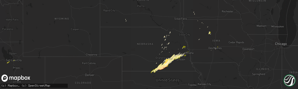
Hail Map in Nebraska on April 18, 2023
The weather event in Nebraska on April 18, 2023 includes Hail map. 7 states and 139 cities were impacted and suffered possible damage. The total estimated number of properties impacted is 27,900.
Want more than just the map?
Turn this storm into a full workflow.
- Owner + property data so you know who to knock
- OnDemand branded weather history reports to win the "did we even have hail?" argument
- RoofTrace estimate so reps stop guessing numbers at the door
Bought this map? Upgrade within 7 days and we'll credit the $230. (10-15 min setup call)
Hail
27,900
Estimated number of impacted properties by a 1.00" hail or larger6,673
Estimated number of impacted properties by a 1.75" hail or larger0
Estimated number of impacted properties by a 2.50" hail or largerStorm reports in Nebraska
Nebraska
| Date | Description |
|---|---|
| 04/18/20231:00 AM CDT | Report from mping: quarter |
| 04/18/202312:48 AM CDT | Relayed via social media. Time estimated from radar. |
| 04/18/202312:43 AM CDT | Uprooted trees and some shore stations and docks tipped over into the lake. Report from social media. |
| 04/18/202312:41 AM CDT | Report from mping: quarter |
| 04/18/202312:35 AM CDT | A local report indicates 1.00 inch wind near 6 S FOSTER |
| 04/17/202311:31 PM CDT | A local report indicates 1.25 inch wind near 6 NE GARLAND |
| 04/17/202311:30 PM CDT | Nickel to quarter sized hail. |
| 04/17/202311:17 PM CDT | Nickel to quarter sized hail. |
| 04/17/202311:12 PM CDT | Report from mping. |
| 04/17/202310:52 PM CDT | A local report indicates 1.00 inch wind near 4 W GRESHAM |
| 04/17/202310:49 PM CDT | A local report indicates 1.00 inch wind near UTICA |
| 04/17/202310:46 PM CDT | A few stones larger than quarter sized. Time estimated from radar. |
| 04/17/202310:06 PM CDT | Nickel to quarter size hail. Time est from radar. |
| 04/17/202310:00 PM CDT | Report via facebook. |
| 04/17/20239:48 PM CDT | A local report indicates 1.00 inch wind near SUTTON |
| 04/17/20239:47 PM CDT | Report from mping: quarter |
| 04/17/20239:45 PM CDT | A local report indicates 1.00 inch wind near STOCKHAM |
| 04/17/20239:45 PM CDT | A local report indicates 1.75 inch wind near SUTTON |
| 04/17/20239:44 PM CDT | Public report with photo on social media. Time estimated from radar. |
| 04/17/20239:31 PM CDT | Via nws chat. |
| 04/17/20239:30 PM CDT | Hail was reported from 930-935. |
| 04/17/20239:24 PM CDT | Picture via facebook with ruler. |
| 04/17/20239:16 PM CDT | A local report indicates 1.00 inch wind near 3 N OAK |
| 04/17/20239:16 PM CDT | A local report indicates 1.25 inch wind near 3 W CLAY CENTER |
| 04/17/20239:15 PM CDT | Motorist on 4400 road reported quarter size hail that cracked the windshield of his vehicle. |
| 04/17/20239:13 PM CDT | Picture via facebook. Time estimated from radar. |
| 04/17/20239:13 PM CDT | Delayed report via facebook. |
| 04/17/20239:04 PM CDT | A local report indicates 1.00 inch wind near 2 E DEWEESE |
| 04/17/20239:03 PM CDT | A local report indicates 1.00 inch wind near DEWEESE |
| 04/17/20238:57 PM CDT | A local report indicates 1.00 inch wind near 4 ESE LAWRENCE |
| 04/17/20238:46 PM CDT | Report from mping: half dollar |
| 04/17/20238:41 PM CDT | Report from mping: golf ball |
| 04/17/20238:41 PM CDT | Report from mping: golf ball |
| 04/17/20238:32 PM CDT | A local report indicates 1.75 inch wind near BLUE HILL |
| 04/17/20238:28 PM CDT | Photo via twitter. |
| 04/17/20238:28 PM CDT | A local report indicates 1.00 inch wind near BLUE HILL |
| 04/17/20238:19 PM CDT | Time estimated from radar data. |
| 04/17/20238:17 PM CDT | Delayed report. Mesonet station knerushv9. |
| 04/17/20238:12 PM CDT | Delayed report. |
| 04/17/20238:10 PM CDT | A local report indicates 1.50 inch wind near 5 N INAVALE |
| 04/17/20238:06 PM CDT | Half dollar and ping pong size hail also fell. Public report relayed via to nws from emergency manager. |
| 04/17/20238:05 PM CDT | Almost enough hail to cover the ground. |
| 04/17/20237:54 PM CDT | Time est from radar. |
| 04/17/20237:38 PM CDT | Report via spotter network. |
| 04/17/20237:36 PM CDT | A local report indicates 1.00 inch wind near FRANKLIN |
| 04/17/20237:24 PM CDT | A local report indicates 1.00 inch wind near 2 W FRANKLIN |
All States Impacted by Hail Map on April 18, 2023
Cities Impacted by Hail Map on April 18, 2023
- Grantsville, UT
- Tooele, UT
- Salt Lake City, UT
- Eldon, MO
- Riverton, NE
- Bloomington, NE
- Franklin, NE
- Naponee, NE
- Phillipsburg, KS
- Alma, NE
- Republican City, NE
- Bladen, NE
- Campbell, NE
- Agra, KS
- Kensington, KS
- Inavale, NE
- Holstein, NE
- Roseland, NE
- Red Cloud, NE
- Blue Hill, NE
- Ayr, NE
- Guide Rock, NE
- Lawrence, NE
- Glenvil, NE
- Fairfield, NE
- Deweese, NE
- Nelson, NE
- Edgar, NE
- Ong, NE
- Clay Center, NE
- Harvard, NE
- Sutton, NE
- Aurora, NE
- Henderson, NE
- Grafton, NE
- Fairmont, NE
- McCool Junction, NE
- Saronville, NE
- Minden, NE
- Giltner, NE
- Upland, NE
- Trumbull, NE
- Seward, NE
- Milford, NE
- Inland, NE
- Hastings, NE
- Saint Paul, NE
- Garland, NE
- Hampton, NE
- York, NE
- Geneva, NE
- Waco, NE
- Exeter, NE
- Benedict, NE
- Utica, NE
- Beaver Crossing, NE
- Gresham, NE
- Staplehurst, NE
- Ulysses, NE
- Stromsburg, NE
- Shelby, NE
- Surprise, NE
- Rising City, NE
- Goehner, NE
- Bee, NE
- Valparaiso, NE
- Dwight, NE
- Raymond, NE
- Ceresco, NE
- Pleasant Dale, NE
- Malcolm, NE
- Lincoln, NE
- Wahoo, NE
- Ithaca, NE
- Vincent, IA
- Thor, IA
- Fort Dodge, IA
- Badger, IA
- Eagle Grove, IA
- Humboldt, IA
- Rogers, NE
- Waterloo, NE
- Albion, NE
- Cedar Rapids, NE
- Duncombe, IA
- Graettinger, IA
- Wallingford, IA
- Avoca, MN
- Clearwater, NE
- Bartlett, NE
- Spalding, NE
- Wanblee, SD
- Omaha, NE
- Brainard, NE
- Newman Grove, NE
- Meadow Grove, NE
- Petersburg, NE
- Tilden, NE
- Farwell, NE
- Fullerton, NE
- Saint Edward, NE
- Hooper, NE
- Wolbach, NE
- Yutan, NE
- Spirit Lake, IA
- Marathon, IA
- Okoboji, IA
- Weston, NE
- Bradshaw, NE
- Waverly, NE
- Malmo, NE
- David City, NE
- Davey, NE
- Prague, NE
- Mead, NE
- Ashland, NE
- Mitchellville, IA
- Gretna, NE
- Winslow, NE
- Herman, NE
- Craig, NE
- Tekamah, NE
- Arlington, NE
- Breda, IA
- Fulda, MN
- Algona, IA
- Royal, NE
- Orchard, NE
- Brunswick, NE
- Clarks, NE
- Ashton, SD
- Plainview, NE
- Creighton, NE
- Orient, SD
- Bloomfield, NE
- Arcadia, IA
- Van Meter, IA
- Webb, IA
- Des Moines, IA


