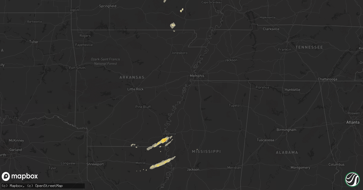
Hail Map in Mississippi on April 18, 2013
Get this storm
April 18 map
$229
one time, instant access
Download today. No call, no setup
Keep the $229
Bought the map and want the full workflow? Apply the entire $229 to a subscription within 7 days. None of it is wasted.
Every map, not just this one
This buys you this map. Subscription and you get every map we run, in the markets you choose from a few cities to whole states to nationwide. Plus real-time alerts the moment a storm fires.
Contact data
Name, contact info, occupancy, even credit band for addresses in the footprint. You go from where it hit to who to call.
Become the source they trust
Unlimited branding weather history reports on demand. You already have the documented answer ready for the property owner, and you are the one who showed up with it.
Property data and RoofTrace estimates
Pull up any address you have got, its value and the exact code rules for that jurisdiction, straight from One Click Code. Then RoofTrace estimates the squares, pitch, and roof value, priced the way you price.
Storm reports in Mississippi
Mississippi
| Date | Description |
|---|---|
| 04/18/20136:35 PM CDT | Reports of a tree down on highland drive and pineland drive. |
| 04/18/20135:30 PM CDT | Nws storm survey found an ef-0 tornado with maximum winds of 75 mph...path length of 0.2 miles and maximum width of 25 yards wide. This brief tornado touched down on de |
| 04/18/20135:23 PM CDT | This brief tornado touched down in an open field and crossed highway 61 near nitta yuma. The tornado was captured on video as it crossed highway 61. No damage occurred. |
| 04/18/20135:22 PM CDT | Brief tornado crossed us highway 61 |
| 04/18/20135:21 PM CDT | This brief tornado touched down in an open field and crossed highway 61 near nitta yuma. The tornado was captured on video as it crossed highway 61. No damage occurred. |
| 04/18/20135:15 PM CDT | A few power lines down near grace along with many large limbs. |
| 04/18/20135:09 PM CDT | This tornado was photographed in an open field near the tribbett community. It remained over open rural areas and caused no damage. Rated ef0 with a path length of 0.4 |
| 04/18/20135:04 PM CDT | Nws storm survey found an ef-1 tornado with maximum winds of 88 mph...path length of 2.0 miles and width of 50 yards wide. This brief tornado touched down near levee ro |
| 04/18/20135:04 PM CDT | Nws storm survey found an ef-1 tornado with maximum winds of 88 mph...path length of 2.0 miles and width of 50 yards wide. This brief tornado touched down near levee ro |
| 04/18/20134:32 PM CDT | Reported near the mississippi river bridge |
| 04/18/20133:21 PM CDT | Tree down on us highway 425 near hamburg |
| 04/17/20139:00 PM CDT | Scattered trees down on powerlines in western part of county. |
All States Impacted by Hail Map on April 18, 2013
Cities Impacted by Hail Map on April 18, 2013
- Parkdale, AR
- Wilmot, AR
- Eudora, AR
- Lake Village, AR
- Salem, MO
- Oak Grove, LA
- Highland, IL
- Pocahontas, IL
- Doniphan, MO
- Red Bud, IL
- New Athens, IL
- Belleville, IL
- Waterloo, IL
- Marissa, IL
- Baldwin, IL
- Evansville, IL
- Smithton, IL
- Columbia, IL
- Hecker, IL
- Millstadt, IL
- Oak Ridge, MO
- Maynard, AR
- Saint Mary, MO
- Sainte Genevieve, MO
- Greenville, MO
- Fredericktown, MO
- Farmington, MO
- Baskin, LA
- Rayville, LA
- Mayersville, MS
- Vicksburg, MS
- Tallulah, LA
- Sondheimer, LA
- Delhi, LA
- Valley Park, MS
- Rolling Fork, MS
- Hollandale, MS
- Belgrade, MO
- Friedheim, MO
- Daisy, MO
- Perryville, MO
- Millersville, MO
- Leland, MS
- Greenville, MS
- Pickens, MS
- Columbia, LA
- Saint Gabriel, LA
- Mill Spring, MO
- Caledonia, MO
- Irondale, MO
- Bismarck, MO
- Oakdale, IL
- Pinckneyville, IL
- Coulterville, IL
- Nashville, IL
- Silva, MO
- Glen Allan, MS
- Chatham, MS
- Breese, IL
- Rockwood, IL
- Strong, AR
- Potosi, MO
- Percy, IL
- Campbell Hill, IL
- Ava, IL
- Vernon, IL
- Vandalia, IL
- Mangham, LA
- Clubb, MO
- Huttig, AR
- Patoka, IL
- Mineral Point, MO
- Jones, LA
- Bastrop, LA
- Marion, LA
- Trenton, IL
- Aviston, IL
- Carlyle, IL
- Farina, IL
- Kinmundy, IL
- Saint Peter, IL
- Holden, LA
- Albany, LA
- Belleview, MO
- Walnut Hill, IL
- Dix, IL
- Centralia, IL


