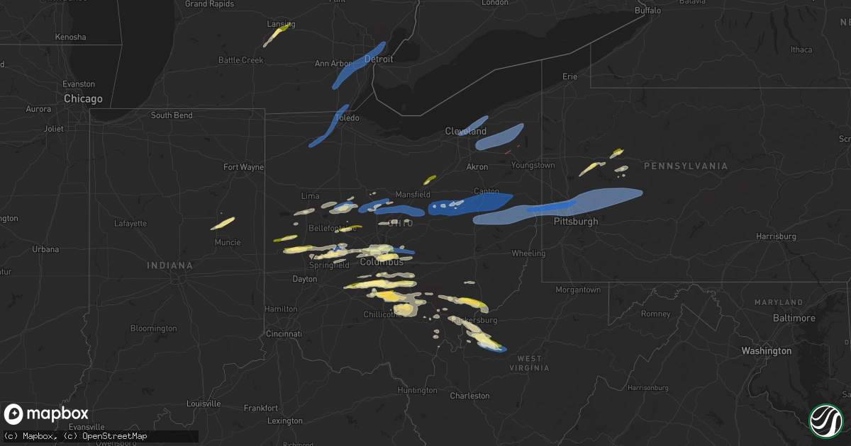
Hail Map in Ohio on April 17, 2024
Get this storm
April 17 map
$229
one time, instant access
Download today. No call, no setup
Keep the $229
Bought the map and want the full workflow? Apply the entire $229 to a subscription within 7 days. None of it is wasted.
Every map, not just this one
This buys you this map. Subscription and you get every map we run, in the markets you choose from a few cities to whole states to nationwide. Plus real-time alerts the moment a storm fires.
Contact data
Name, contact info, occupancy, even credit band for addresses in the footprint. You go from where it hit to who to call.
Become the source they trust
Unlimited branding weather history reports on demand. You already have the documented answer ready for the property owner, and you are the one who showed up with it.
Property data and RoofTrace estimates
Pull up any address you have got, its value and the exact code rules for that jurisdiction, straight from One Click Code. Then RoofTrace estimates the squares, pitch, and roof value, priced the way you price.
Storm reports in Ohio
Ohio
| Date | Description |
|---|---|
| 04/17/20246:55 PM CDT | Delayed report. An employee with the burr oak lodge in morgan county advised there was a tree down along sr-78 near the lodge. Time estimated via radar. |
| 04/17/20246:44 PM CDT | Trees down. Time estimated based on radar. |
| 04/17/20246:42 PM CDT | Report from mping: 1-inch tree limbs broken; shingles blown off. |
| 04/17/20246:25 PM CDT | Tree down. |
| 04/17/20246:15 PM CDT | Delayed report. State garage in morgan county had a large tree down blocking part of sr-669 near the muskingum county line. Time estimated by radar. |
| 04/17/20246:11 PM CDT | Delayed report... Multiple trees down along with large limbs on bristol champion townline rd ne west of n park ave. |
| 04/17/20246:04 PM CDT | Delayed report... Damage to a roof along with several large trees down... One of which was on a garage. A camper was also blown over. |
| 04/17/20246:03 PM CDT | Report and photo of large tree down on titanium way. Time estimated based on radar. |
| 04/17/20246:01 PM CDT | A few trees down on high hill road. |
| 04/17/20246:01 PM CDT | Nws storm damage survey confirmed an ef-0 tornado with estimated peak winds of 80 mph in southington and champion townships in oh. The damage path length is 2.96 miles |
| 04/17/20245:58 PM CDT | A local report indicates 1.50 inch wind near 3 W Stoutsville |
| 04/17/20245:52 PM CDT | A local report indicates 1.00 inch wind near 1 E Lancaster |
| 04/17/20245:52 PM CDT | A local report indicates 1.00 inch wind near Circleville |
| 04/17/20245:51 PM CDT | Trees were reported down on north liberty street near buckeye street in new concord. |
| 04/17/20245:51 PM CDT | Nws storm damage survey confirmed an ef-1 tornado with estimated peak winds of 110 mph in windham... Oh. The damage path length is 3.99 miles and maximum width is 65 ya |
| 04/17/20245:50 PM CDT | A local report indicates 1.00 inch wind near 5 E Williamsport |
| 04/17/20245:48 PM CDT | House damaged on county road 229 south of state route 82. Time estimated via radar. |
| 04/17/20245:47 PM CDT | Drone footage photo shows extensive damage to a house that was shifted off of the foundation. There was also an overturned vehicle. Time estimate via radar. |
| 04/17/20245:46 PM CDT | Tree down on state route 303. |
| 04/17/20245:45 PM CDT | Report of at least one tractor trailer blown over on eastbound lanes of ohio turnpike |
| 04/17/20245:40 PM CDT | Trees were reported down on route 30 and on 2nd street in hanoverton. |
| 04/17/20245:40 PM CDT | A local report indicates 1.00 inch wind near Lancaster |
| 04/17/20245:35 PM CDT | Trees down on state route 9 near pledge road |
| 04/17/20245:29 PM CDT | Tree down. |
| 04/17/20245:25 PM CDT | Tree down on unoccupied cabin on concord drive near leesville lake. Tim estimated from radar. |
| 04/17/20245:25 PM CDT | Tree down on military road. Time estimated from radar. |
| 04/17/20245:19 PM CDT | A local report indicates 1.25 inch wind near Darbyville |
| 04/17/20245:15 PM CDT | A local report indicates 1.00 inch wind near South Bloomfield |
| 04/17/20245:15 PM CDT | A local report indicates 1.00 inch wind near Ashville |
| 04/17/20245:10 PM CDT | One down tree and several large branches. |
| 04/17/20245:08 PM CDT | Large branches down. |
| 04/17/20245:06 PM CDT | Asos station kbkl cleveland. |
| 04/17/20245:05 PM CDT | A local report indicates 1.50 inch wind near 3 W South Bloomfield |
| 04/17/20245:00 PM CDT | A local report indicates 1.00 inch wind near Lithopolis |
| 04/17/20244:50 PM CDT | A local report indicates 1.00 inch wind near 4 E Mount Sterling |
| 04/17/20244:44 PM CDT | A local report indicates 1.00 inch wind near Gahanna |
| 04/17/20244:38 PM CDT | A local report indicates 1.00 inch wind near 2 NW Gahanna |
| 04/17/20244:37 PM CDT | A local report indicates 1.00 inch wind near Gahanna |
| 04/17/20244:37 PM CDT | A local report indicates 1.00 inch wind near 2 NNE Whitehall |
| 04/17/20244:35 PM CDT | Awos station k10g 2 wsw millersburg. |
| 04/17/20244:35 PM CDT | A local report indicates 1.00 inch wind near 3 NE Grandview Heights |
| 04/17/20244:35 PM CDT | A local report indicates 1.00 inch wind near 2 NNE Whitehall |
| 04/17/20244:30 PM CDT | A local report indicates 1.00 inch wind near 2 S Riverlea |
| 04/17/20244:30 PM CDT | Delayed report of tree downed in millersburg. Time estimated via radar. |
| 04/17/20244:30 PM CDT | Delayed report of tree downed in killbuck. Time estimated via radar. |
| 04/17/20244:30 PM CDT | A local report indicates 1.00 inch wind near Johnstown |
| 04/17/20244:29 PM CDT | Damage to several houses on fancher road. |
| 04/17/20244:28 PM CDT | Tree down on tr 91. |
| 04/17/20244:26 PM CDT | Shingles blown off roof. |
| 04/17/20244:26 PM CDT | Ef1 tornado caused tree and structural damage... With maximum winds of 90 mph. Path length of 0.9 miles. |
| 04/17/20244:22 PM CDT | Tree down near the intersection of sr 754 and cr 320. Time estimated via radar. |
| 04/17/20244:22 PM CDT | Large tree limbs down. |
| 04/17/20244:19 PM CDT | Tree down across tr 222. |
| 04/17/20244:18 PM CDT | Tree downed in big prairie. Delayed report. Time estimated via radar. |
| 04/17/20244:18 PM CDT | A local report indicates 1.00 inch wind near westerville |
| 04/17/20244:05 PM CDT | A local report indicates 1.00 inch wind near 3 SE Dublin |
| 04/17/20244:05 PM CDT | A local report indicates 59 MPH wind near 3 W Riverlea |
| 04/17/20243:51 PM CDT | Multiple trees down on route 97 between butler and bellville. One and a half foot in diameter trees snapped about 3 feet above ground. Time estimated via rad |
| 04/17/20243:51 PM CDT | Multiple trees down on route 97 between butler and bellville. One and a half foot in diameter trees snapped about 3 feet above ground. Time estimated via radar. |
| 04/17/20243:21 PM CDT | Ef0 tornado caused tree and structural damage... With maximum winds of 75 mph. Path length of 3.0 miles. |
| 04/17/20243:15 PM CDT | Lasted almost 5 minutes. |
| 04/17/20243:08 PM CDT | Emergency management... Law enforcement... And trained spotters report several instances of structural damage to homes and businesses in bucyrus. Numerous trees down as |
| 04/17/20243:08 PM CDT | Trees snapped a couple of feet above ground in addition to several trees uprooted and structural failure of what appears to be a shed or outbuilding on e mansfield st. |
| 04/17/20243:06 PM CDT | Nws storm damage survey confirmed an ef-1 tornado with estimated peak winds of 110 mph in bucyrus... Oh. The damage path length is 3.48 miles and maximum width is 100 y |
| 04/17/20243:06 PM CDT | Asos station kmnn marion. |
| 04/17/20243:05 PM CDT | Estimated 60-70 mph wind gust and pea size hail. |
| 04/17/20243:01 PM CDT | Power lines down near the intersection of university drive and 309. Time estimated via radar. |
| 04/17/20243:01 PM CDT | Tree and utility poles down. |
| 04/17/20242:50 PM CDT | Delayed report. |
| 04/17/20242:38 PM CDT | Tree down near intersection of cr-144 and township road 199. Time estimated from radar. |
| 04/17/20242:30 PM CDT | A local report indicates 1.00 inch wind near Piqua |
| 04/17/20242:01 PM CDT | Multiple large branches down. Time estimated via radar. |
| 04/17/20241:59 PM CDT | 12-15 inch diameter tree snapped off. Time estimated from radar. |
| 04/17/20241:06 PM CDT | Large tree limbs down. |
| 04/17/20241:05 PM CDT | Semi truck blown over near intersection of oh-15 and cr-i. No injuries reported. |
| 04/17/20241:00 PM CDT | Report of severe damage to a home in the 14000 block of county road f. No other information at this time. |
| 04/17/20241:00 PM CDT | Tree downed halfway across cr 13 off of w high street. No information on size or health of the tree. |
| 04/17/20241:00 PM CDT | Box truck blown over. Time estimated from radar. |
| 04/17/202412:53 PM CDT | Peaked metal roof blown off hog building. Time estimated from radar. |
| 04/16/20247:55 PM CDT | Spotter observed 1 inch hail on property. |
| 04/16/20247:34 PM CDT | Report from mping: quarter |
| 04/16/20247:30 PM CDT | Minor leaf damage due to hail. |
| 04/16/20247:25 PM CDT | Trained spotter reports largest hail size of 1 inch under a severe storm. |
All States Impacted by Hail Map on April 17, 2024
Cities Impacted by Hail Map on April 17, 2024
- Gaston, IN
- Matthews, IN
- Fairmount, IN
- Hartford City, IN
- Upland, IN
- Muncie, IN
- Summitville, IN
- Eaton Rapids, MI
- Charlotte, MI
- Dimondale, MI
- Holt, MI
- Lansing, MI
- Coldwater, OH
- Okemos, MI
- East Lansing, MI
- Mason, MI
- Saint Henry, OH
- Haslett, MI
- New Knoxville, OH
- Saint Marys, OH
- Wapakoneta, OH
- Marion, IN
- Minster, OH
- Anna, OH
- Ansonia, OH
- Versailles, OH
- Waynesfield, OH
- Harrod, OH
- Belle Center, OH
- Russia, OH
- Houston, OH
- Sidney, OH
- Alger, OH
- Kenton, OH
- Bradford, OH
- Covington, OH
- Piqua, OH
- Troy, OH
- Pleasant Hill, OH
- Arcanum, OH
- Greenville, OH
- Fletcher, OH
- Dundee, MI
- Milan, MI
- Maybee, MI
- Willis, MI
- Romulus, MI
- Belleville, MI
- Ypsilanti, MI
- Wayne, MI
- Detroit, MI
- Taylor, MI
- Westland, MI
- Dearborn Heights, MI
- Canton, MI
- Redford, MI
- Inkster, MI
- Garden City, MI
- Dearborn, MI
- Mount Victory, OH
- Ridgeway, OH
- Allen Park, MI
- Forest, OH
- Upper Sandusky, OH
- Rushsylvania, OH
- Conover, OH
- Napoleon, OH
- McClure, OH
- Malinta, OH
- Grelton, OH
- Liberty Center, OH
- Waterville, OH
- Grand Rapids, OH
- Whitehouse, OH
- Monclova, OH
- Maumee, OH
- Toledo, OH
- Holland, OH
- Sylvania, OH
- Lambertville, MI
- Ottawa Lake, MI
- Temperance, MI
- Erie, MI
- Zanesfield, OH
- East Liberty, OH
- West Mansfield, OH
- La Rue, OH
- Bellefontaine, OH
- Hamtramck, MI
- Highland Park, MI
- Casstown, OH
- New Bloomington, OH
- Hazel Park, MI
- Center Line, MI
- Roseville, MI
- Warren, MI
- Eastpointe, MI
- Royal Oak, MI
- Madison Heights, MI
- Ferndale, MI
- Fraser, MI
- Sterling Heights, MI
- Raymond, OH
- Grosse Pointe, MI
- Harper Woods, MI
- Marysville, OH
- Richwood, OH
- Ashland, OH
- Polk, OH
- West Salem, OH
- Urbana, OH
- Saint Paris, OH
- Marion, OH
- Harpster, OH
- Nevada, OH
- Bucyrus, OH
- Morral, OH
- Caledonia, OH
- Galion, OH
- Cable, OH
- Woodstock, OH
- Mechanicsburg, OH
- Springfield, OH
- New Carlisle, OH
- Christiansburg, OH
- Cardington, OH
- Edison, OH
- Mount Gilead, OH
- Mansfield, OH
- Bellville, OH
- Fredericktown, OH
- North Lewisburg, OH
- Tremont City, OH
- North Hampton, OH
- Butler, OH
- Danville, OH
- Howard, OH
- Ashley, OH
- Marengo, OH
- Fulton, OH
- Irwin, OH
- Dublin, OH
- Plain City, OH
- Columbus, OH
- Amlin, OH
- Powell, OH
- Westerville, OH
- New Albany, OH
- London, OH
- Hilliard, OH
- South Vienna, OH
- Galena, OH
- Lewis Center, OH
- Loudonville, OH
- Big Prairie, OH
- Lakeville, OH
- Washington Court House, OH
- Jeffersonville, OH
- Bloomingburg, OH
- Mount Sterling, OH
- Blacklick, OH
- Pataskala, OH
- Johnstown, OH
- Alexandria, OH
- Granville, OH
- Newark, OH
- Shreve, OH
- Millersburg, OH
- Perrysville, OH
- Glenmont, OH
- Fredericksburg, OH
- Holmesville, OH
- Killbuck, OH
- Brinkhaven, OH
- Dundee, OH
- Apple Creek, OH
- Dover, OH
- Beach City, OH
- Wilmot, OH
- Strasburg, OH
- Sugarcreek, OH
- Brewster, OH
- Navarre, OH
- Mount Eaton, OH
- Bolivar, OH
- Zoar, OH
- East Sparta, OH
- Orient, OH
- Williamsport, OH
- Circleville, OH
- Dalton, OH
- Canton, OH
- Ashville, OH
- Somerdale, OH
- Mineral City, OH
- Lohn, TX
- Brady, TX
- Lockbourne, OH
- Reynoldsburg, OH
- Magnolia, OH
- Sandyville, OH
- Massillon, OH
- East Canton, OH
- Dellroy, OH
- Waynesburg, OH
- Canal Winchester, OH
- Carroll, OH
- Groveport, OH
- Lithopolis, OH
- Heath, OH
- Hebron, OH
- Malvern, OH
- Minerva, OH
- Robertsville, OH
- Paris, OH
- Carrollton, OH
- East Rochester, OH
- New Philadelphia, OH
- Stone Creek, OH
- Uhrichsville, OH
- Midvale, OH
- Gnadenhutten, OH
- Dennison, OH
- Sherrodsville, OH
- Scio, OH
- Bowerston, OH
- Leesville, OH
- Kensington, OH
- Millersport, OH
- New Holland, OH
- Baltimore, OH
- Pleasantville, OH
- Lancaster, OH
- Sligo, PA
- Rochelle, TX
- Clarion, PA
- Strattanville, PA
- Jewett, OH
- Amsterdam, OH
- Salineville, OH
- Bergholz, OH
- Mechanicstown, OH
- Windham, OH
- Shippenville, PA
- Amanda, OH
- Clarksburg, OH
- Stoutsville, OH
- Fairmount City, PA
- New Bethlehem, PA
- Mayport, PA
- Cleveland, OH
- Lakewood, OH
- Euclid, OH
- Willoughby, OH
- Wickliffe, OH
- Eastlake, OH
- Mentor, OH
- Southington, OH
- Laurelville, OH
- Rockbridge, OH
- Richmond, OH
- Irondale, OH
- Bloomingdale, OH
- East Springfield, OH
- Hammondsville, OH
- New Cumberland, WV
- Toronto, OH
- Wellsville, OH
- Empire, OH
- Stratton, OH
- Newell, WV
- Warren, OH
- Bedford, OH
- Macedonia, OH
- Solon, OH
- Twinsburg, OH
- Hudson, OH
- Northfield, OH
- Aurora, OH
- Chagrin Falls, OH
- Hiram, OH
- Mantua, OH
- Newbury, OH
- Burton, OH
- Garrettsville, OH
- West Farmington, OH
- Middlefield, OH
- North Bloomfield, OH
- Orwell, OH
- Windsor, OH
- Huntsburg, OH
- Rome, OH
- Rushville, OH
- Sugar Grove, OH
- Bremen, OH
- Georgetown, PA
- Chester, WV
- New Manchester, WV
- Hookstown, PA
- Clinton, PA
- Aliquippa, PA
- Midland, PA
- Industry, PA
- Shippingport, PA
- East Liverpool, OH
- Crescent, PA
- Coraopolis, PA
- Ambridge, PA
- Sewickley, PA
- South Heights, PA
- Leetsdale, PA
- Monaca, PA
- Conway, PA
- Baden, PA
- Pittsburgh, PA
- Wexford, PA
- Freedom, PA
- Warrendale, PA
- Mars, PA
- Cranberry Township, PA
- Bradfordwoods, PA
- Tarlton, OH
- Kingston, OH
- Logan, OH
- Glouster, OH
- New Straitsville, OH
- Chillicothe, OH
- Karns City, PA
- Petrolia, PA
- Gibsonia, PA
- Cheswick, PA
- Allison Park, PA
- Glenshaw, PA
- Butler, PA
- Bakerstown, PA
- Bairdford, PA
- Valencia, PA
- Natrona Heights, PA
- Tarentum, PA
- Freeport, PA
- Sarver, PA
- Leechburg, PA
- Russellton, PA
- Saxonburg, PA
- Cabot, PA
- South Bloomingville, OH
- Parker, PA
- Chesterhill, OH
- Malta, OH
- New Kensington, PA
- Creighton, PA
- Brackenridge, PA
- Indianola, PA
- Hyde Park, PA
- Vandergrift, PA
- Worthington, PA
- Ford City, PA
- Apollo, PA
- Kittanning, PA
- Spring Church, PA
- McGrann, PA
- Ford Cliff, PA
- Manorville, PA
- Shelocta, PA
- Springdale, PA
- Cadogan, PA
- Harwick, PA
- Stockport, OH
- Waterford, OH
- Caldwell, OH
- Creola, OH
- The Plains, OH
- Millfield, OH
- Athens, OH
- Haydenville, OH
- Nelsonville, OH
- Union Furnace, OH
- Fleming, OH
- Lowell, OH
- Elderton, PA
- Creekside, PA
- Rural Valley, PA
- Indiana, PA
- East Vandergrift, PA
- Yatesboro, PA
- Sagamore, PA
- Dayton, PA
- West Sunbury, PA
- Londonderry, OH
- McArthur, OH
- Brackettville, TX
- Vincent, OH
- New Plymouth, OH
- Bruin, PA
- Callensburg, PA
- Amesville, OH
- Marietta, OH
- Smicksburg, PA
- Marion Center, PA
- Home, PA
- Rochester Mills, PA
- Glen Campbell, PA
- Clymer, PA
- Cutler, OH
- Whipple, OH
- Guysville, OH
- Coolville, OH
- Stewart, OH
- Paint Rock, TX
- Eola, TX
- Williamstown, WV
- Reno, OH
- Newport, OH
- Little Hocking, OH
- Washington, WV
- Rockport, WV
- Belleville, WV
- Eden, TX
- Mineral Wells, WV
- Parkersburg, WV
- Millersview, TX
- New Marshfield, OH
- Albany, OH
- Elizabeth, WV
- Ballinger, TX
- Palestine, WV
- Rutland, OH
- Pomeroy, OH
- Talpa, TX
- Walker, WV
- Creston, WV
- Munday, WV
- Big Bend, WV
- Voss, TX
- Coleman, TX
- Valera, TX
- Langsville, OH
- Gaylord, KS
- Ravenswood, WV
- Doole, TX
- Middleport, OH
- Reedy, WV
- Grantsville, WV
- Cheshire, OH
- Mount Zion, WV
- Gouldbusk, TX
- Le Roy, WV
- Spencer, WV
- Arnoldsburg, WV
- Smith Center, KS
- Manhattan, KS
- Junction City, KS
- Lebanon, KS
- Saint George, KS
- Rossville, KS
- Silver Lake, KS
- Alma, KS
- Eskridge, KS
- Wamego, KS
- Maple Hill, KS
- Paxico, KS
- Clendenin, WV
- Bomont, WV
- Agenda, KS
- Cuba, KS
- Topeka, KS
- McFarland, KS
- Belleville, KS
- Harveyville, KS
- Lawrence, KS
- Clyde, KS
- Clifton, KS
- Haddam, KS
- Morrowville, KS
- Linn, KS
- Palmer, KS
- Berryton, KS
- Lecompton, KS
- Washington, KS
- Belvue, KS
- Greenleaf, KS
- Auburn, KS
- Burlingame, KS
- Carbondale, KS
- Barnes, KS
- Wakarusa, KS
- Waterville, KS
- Tecumseh, KS
- Grantville, KS
- Meriden, KS
- Perry, KS
- Saint Marys, KS
- Scranton, KS
- Westmoreland, KS
- Olsburg, KS
- Onaga, KS
- Emmett, KS
- Delia, KS
- Mayetta, KS
- Hoyt, KS
- Denison, KS
- Ozawkie, KS
- Valley Falls, KS
- Oskaloosa, KS
- Atchison, KS
- Nortonville, KS
- Cummings, KS
- Tonganoxie, KS
- McLouth, KS
- Linwood, KS
- Fort Leavenworth, KS
- Easton, KS
- Leavenworth, KS
- Bonner Springs, KS
- Basehor, KS
- Kansas City, KS
- Weston, MO
- Platte City, MO
- Shawnee, KS
- Winchester, KS
- Holton, KS
- Effingham, KS
- Muscotah, KS
- Lancaster, KS
- Saint Joseph, MO
- De Kalb, MO
- Faucett, MO
- Dearborn, MO
- Rushville, MO
- Agency, MO
- Kansas City, MO
- Waldron, MO
- Mission, KS
- Lansing, KS
- Camden Point, MO
- Overland Park, KS
- Farley, MO
- Wathena, KS
- Elwood, KS
- Edgerton, MO
- Smithville, MO
- Riverside, MO
- Prairie Village, KS
- Independence, MO
- Plattsburg, MO
- Trimble, MO
- Easton, MO
- Holt, MO
- Kearney, MO
- Gower, MO
- Lathrop, MO
- Liberty, MO
- Stewartsville, MO
- Troy, KS
- Buckner, MO
- Missouri City, MO
- Sibley, MO
- Orrick, MO
- Blue Springs, MO
- Excelsior Springs, MO
- Levasy, MO
- Camden, MO
- Lawson, MO
- Richmond, MO
- Rayville, MO
- Turney, MO
- Gallatin, MO
- Cameron, MO
- Polo, MO
- Kingston, MO
- Soldier, KS
- Havensville, KS


