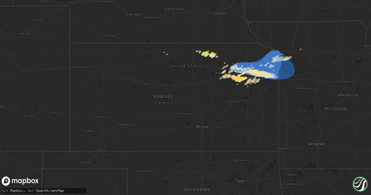
Hail Map in Kansas on April 17, 2024
Get this storm
April 17 map
$229
one time, instant access
Download today. No call, no setup
Keep the $229
Bought the map and want the full workflow? Apply the entire $229 to a subscription within 7 days. None of it is wasted.
Every map, not just this one
This buys you this map. Subscription and you get every map we run, in the markets you choose from a few cities to whole states to nationwide. Plus real-time alerts the moment a storm fires.
Contact data
Name, contact info, occupancy, even credit band for addresses in the footprint. You go from where it hit to who to call.
Become the source they trust
Unlimited branding weather history reports on demand. You already have the documented answer ready for the property owner, and you are the one who showed up with it.
Property data and RoofTrace estimates
Pull up any address you have got, its value and the exact code rules for that jurisdiction, straight from One Click Code. Then RoofTrace estimates the squares, pitch, and roof value, priced the way you price.
Storm reports in Kansas
Kansas
| Date | Description |
|---|---|
| 04/17/202411:58 AM CDT | A local report indicates 1.00 inch wind near 1 S Rossville |
| 04/17/20243:39 AM CDT | Downed power lines and power outages near el monte street. Time estimated from radar and power outage report. |
| 04/17/20243:38 AM CDT | 64 mph wind gust and dime sized hail covering the ground. |
| 04/17/20243:32 AM CDT | Downed tree limbs and wires near georgia avenue. Time estimated from radar and power outage report time. |
| 04/17/20243:28 AM CDT | Delayed social media report of quarter size hail in basehor. Time estimated from radar. |
| 04/17/20243:23 AM CDT | Tree reportedly fell onto powerline. Time estimated from radar. |
| 04/17/20243:15 AM CDT | A local report indicates 60 MPH wind near Tonganoxie |
| 04/17/20243:10 AM CDT | Kdot sensor k1lvw. |
| 04/17/20242:57 AM CDT | Multiple reports of wires down and power outages in northeastern leavenworth county. Time estimated from radar. |
| 04/17/20242:56 AM CDT | Property damage reported with the west half of the roof lost. |
| 04/17/20242:50 AM CDT | Roof of house blown off. |
| 04/17/20242:45 AM CDT | A local report indicates 1.00 inch wind near 4 SSE Ozawkie |
| 04/17/20242:45 AM CDT | Delayed report. Vehicle blown over and damage to a residence in the lancaster area. Time estimated from radar. |
| 04/17/20242:36 AM CDT | Downed power lines and power outages near 214th rd. Time estimated from radar. |
| 04/17/20242:35 AM CDT | Social media report of damage to multiple buildings and trees at a farm one mile nw of nortonville near greeley road. Time estimated from radar. |
| 04/17/20242:31 AM CDT | Delayed report. Time estimated from radar. Shop was blown down. |
| 04/17/20242:27 AM CDT | Delayed report. Time estimated from radar. Barn collapsed. |
| 04/17/20242:27 AM CDT | Delayed report. Time estimated from radar. Lost roof on barn. |
| 04/17/20242:25 AM CDT | Multiple trees damaged... Power lines down. |
| 04/17/20242:25 AM CDT | Delayed report. Conifer/cedar tree greater than 6 inches in diameter snapped in half mid-trunk and downed. |
| 04/17/20242:24 AM CDT | Delayed report. Time estimated from radar. Barn blown down. |
| 04/17/20242:24 AM CDT | Delayed report. Time estimated from radar. Barn blown down and damage to a semi truck. |
| 04/17/20242:22 AM CDT | Barn blew down by severe wind gust. Time estimated by radar. |
| 04/17/20242:05 AM CDT | A local report indicates 70 MPH wind near 5 WNW Mayetta |
| 04/17/20241:58 AM CDT | Delayed report... Time estimated from radar. Several large trees down. |
| 04/17/20241:57 AM CDT | Delayed report... Time estimated from radar. Older barn blown over into roadway. |
| 04/17/20241:52 AM CDT | Downed tree limbs and wires near nebraska avenue. Time estimated from radar. |
| 04/17/20241:48 AM CDT | Report from mping: quarter |
| 04/17/20241:46 AM CDT | Numerous trees damaged with a couple large hardwood trunks snaped. Damage to the high school roof too. |
| 04/17/20241:45 AM CDT | Delayed report. Back door smashed in by flying debris... 1500 gallon plastic cisterns completely gone... Power out. |
| 04/17/20241:30 AM CDT | Several large branches down... Playset overturned... Power out. |
| 04/17/202412:16 AM CDT | A local report indicates 1.50 inch wind near 6 SSE Silver Lake |
| 04/17/202412:16 AM CDT | A local report indicates 1.50 inch wind near 7 WSW Topeka |
| 04/17/202412:16 AM CDT | A local report indicates 1.00 inch wind near 7 WNW Pauline |
| 04/17/202412:15 AM CDT | A local report indicates 1.50 inch wind near 6 NE Dover |
| 04/17/202412:15 AM CDT | A local report indicates 1.50 inch wind near 7 SSE Silver Lake |
| 04/17/202412:09 AM CDT | Report from mping: quarter |
| 04/17/202412:08 AM CDT | A local report indicates 1.00 inch wind near 5 NE Dover |
| 04/16/202411:56 PM CDT | A local report indicates 1.00 inch wind near 2 NW Dover |
| 04/16/202411:29 PM CDT | A local report indicates 1.25 inch wind near Clyde |
| 04/16/202411:24 PM CDT | Between mile markers 332 to 333 along i-70. |
| 04/16/202411:00 PM CDT | Power poles down near 110th and vale road. |
| 04/16/202410:42 PM CDT | A local report indicates 1.00 inch wind near Eskridge |
All States Impacted by Hail Map on April 17, 2024
Cities Impacted by Hail Map on April 17, 2024
- Gaston, IN
- Matthews, IN
- Fairmount, IN
- Hartford City, IN
- Upland, IN
- Muncie, IN
- Summitville, IN
- Eaton Rapids, MI
- Charlotte, MI
- Dimondale, MI
- Holt, MI
- Lansing, MI
- Coldwater, OH
- Okemos, MI
- East Lansing, MI
- Mason, MI
- Saint Henry, OH
- Haslett, MI
- New Knoxville, OH
- Saint Marys, OH
- Wapakoneta, OH
- Marion, IN
- Minster, OH
- Anna, OH
- Ansonia, OH
- Versailles, OH
- Waynesfield, OH
- Harrod, OH
- Belle Center, OH
- Russia, OH
- Houston, OH
- Sidney, OH
- Alger, OH
- Kenton, OH
- Bradford, OH
- Covington, OH
- Piqua, OH
- Troy, OH
- Pleasant Hill, OH
- Arcanum, OH
- Greenville, OH
- Fletcher, OH
- Dundee, MI
- Milan, MI
- Maybee, MI
- Willis, MI
- Romulus, MI
- Belleville, MI
- Ypsilanti, MI
- Wayne, MI
- Detroit, MI
- Taylor, MI
- Westland, MI
- Dearborn Heights, MI
- Canton, MI
- Redford, MI
- Inkster, MI
- Garden City, MI
- Dearborn, MI
- Mount Victory, OH
- Ridgeway, OH
- Allen Park, MI
- Forest, OH
- Upper Sandusky, OH
- Rushsylvania, OH
- Conover, OH
- Napoleon, OH
- McClure, OH
- Malinta, OH
- Grelton, OH
- Liberty Center, OH
- Waterville, OH
- Grand Rapids, OH
- Whitehouse, OH
- Monclova, OH
- Maumee, OH
- Toledo, OH
- Holland, OH
- Sylvania, OH
- Lambertville, MI
- Ottawa Lake, MI
- Temperance, MI
- Erie, MI
- Zanesfield, OH
- East Liberty, OH
- West Mansfield, OH
- La Rue, OH
- Bellefontaine, OH
- Hamtramck, MI
- Highland Park, MI
- Casstown, OH
- New Bloomington, OH
- Hazel Park, MI
- Center Line, MI
- Roseville, MI
- Warren, MI
- Eastpointe, MI
- Royal Oak, MI
- Madison Heights, MI
- Ferndale, MI
- Fraser, MI
- Sterling Heights, MI
- Raymond, OH
- Grosse Pointe, MI
- Harper Woods, MI
- Marysville, OH
- Richwood, OH
- Ashland, OH
- Polk, OH
- West Salem, OH
- Urbana, OH
- Saint Paris, OH
- Marion, OH
- Harpster, OH
- Nevada, OH
- Bucyrus, OH
- Morral, OH
- Caledonia, OH
- Galion, OH
- Cable, OH
- Woodstock, OH
- Mechanicsburg, OH
- Springfield, OH
- New Carlisle, OH
- Christiansburg, OH
- Cardington, OH
- Edison, OH
- Mount Gilead, OH
- Mansfield, OH
- Bellville, OH
- Fredericktown, OH
- North Lewisburg, OH
- Tremont City, OH
- North Hampton, OH
- Butler, OH
- Danville, OH
- Howard, OH
- Ashley, OH
- Marengo, OH
- Fulton, OH
- Irwin, OH
- Dublin, OH
- Plain City, OH
- Columbus, OH
- Amlin, OH
- Powell, OH
- Westerville, OH
- New Albany, OH
- London, OH
- Hilliard, OH
- South Vienna, OH
- Galena, OH
- Lewis Center, OH
- Loudonville, OH
- Big Prairie, OH
- Lakeville, OH
- Washington Court House, OH
- Jeffersonville, OH
- Bloomingburg, OH
- Mount Sterling, OH
- Blacklick, OH
- Pataskala, OH
- Johnstown, OH
- Alexandria, OH
- Granville, OH
- Newark, OH
- Shreve, OH
- Millersburg, OH
- Perrysville, OH
- Glenmont, OH
- Fredericksburg, OH
- Holmesville, OH
- Killbuck, OH
- Brinkhaven, OH
- Dundee, OH
- Apple Creek, OH
- Dover, OH
- Beach City, OH
- Wilmot, OH
- Strasburg, OH
- Sugarcreek, OH
- Brewster, OH
- Navarre, OH
- Mount Eaton, OH
- Bolivar, OH
- Zoar, OH
- East Sparta, OH
- Orient, OH
- Williamsport, OH
- Circleville, OH
- Dalton, OH
- Canton, OH
- Ashville, OH
- Somerdale, OH
- Mineral City, OH
- Lohn, TX
- Brady, TX
- Lockbourne, OH
- Reynoldsburg, OH
- Magnolia, OH
- Sandyville, OH
- Massillon, OH
- East Canton, OH
- Dellroy, OH
- Waynesburg, OH
- Canal Winchester, OH
- Carroll, OH
- Groveport, OH
- Lithopolis, OH
- Heath, OH
- Hebron, OH
- Malvern, OH
- Minerva, OH
- Robertsville, OH
- Paris, OH
- Carrollton, OH
- East Rochester, OH
- New Philadelphia, OH
- Stone Creek, OH
- Uhrichsville, OH
- Midvale, OH
- Gnadenhutten, OH
- Dennison, OH
- Sherrodsville, OH
- Scio, OH
- Bowerston, OH
- Leesville, OH
- Kensington, OH
- Millersport, OH
- New Holland, OH
- Baltimore, OH
- Pleasantville, OH
- Lancaster, OH
- Sligo, PA
- Rochelle, TX
- Clarion, PA
- Strattanville, PA
- Jewett, OH
- Amsterdam, OH
- Salineville, OH
- Bergholz, OH
- Mechanicstown, OH
- Windham, OH
- Shippenville, PA
- Amanda, OH
- Clarksburg, OH
- Stoutsville, OH
- Fairmount City, PA
- New Bethlehem, PA
- Mayport, PA
- Cleveland, OH
- Lakewood, OH
- Euclid, OH
- Willoughby, OH
- Wickliffe, OH
- Eastlake, OH
- Mentor, OH
- Southington, OH
- Laurelville, OH
- Rockbridge, OH
- Richmond, OH
- Irondale, OH
- Bloomingdale, OH
- East Springfield, OH
- Hammondsville, OH
- New Cumberland, WV
- Toronto, OH
- Wellsville, OH
- Empire, OH
- Stratton, OH
- Newell, WV
- Warren, OH
- Bedford, OH
- Macedonia, OH
- Solon, OH
- Twinsburg, OH
- Hudson, OH
- Northfield, OH
- Aurora, OH
- Chagrin Falls, OH
- Hiram, OH
- Mantua, OH
- Newbury, OH
- Burton, OH
- Garrettsville, OH
- West Farmington, OH
- Middlefield, OH
- North Bloomfield, OH
- Orwell, OH
- Windsor, OH
- Huntsburg, OH
- Rome, OH
- Rushville, OH
- Sugar Grove, OH
- Bremen, OH
- Georgetown, PA
- Chester, WV
- New Manchester, WV
- Hookstown, PA
- Clinton, PA
- Aliquippa, PA
- Midland, PA
- Industry, PA
- Shippingport, PA
- East Liverpool, OH
- Crescent, PA
- Coraopolis, PA
- Ambridge, PA
- Sewickley, PA
- South Heights, PA
- Leetsdale, PA
- Monaca, PA
- Conway, PA
- Baden, PA
- Pittsburgh, PA
- Wexford, PA
- Freedom, PA
- Warrendale, PA
- Mars, PA
- Cranberry Township, PA
- Bradfordwoods, PA
- Tarlton, OH
- Kingston, OH
- Logan, OH
- Glouster, OH
- New Straitsville, OH
- Chillicothe, OH
- Karns City, PA
- Petrolia, PA
- Gibsonia, PA
- Cheswick, PA
- Allison Park, PA
- Glenshaw, PA
- Butler, PA
- Bakerstown, PA
- Bairdford, PA
- Valencia, PA
- Natrona Heights, PA
- Tarentum, PA
- Freeport, PA
- Sarver, PA
- Leechburg, PA
- Russellton, PA
- Saxonburg, PA
- Cabot, PA
- South Bloomingville, OH
- Parker, PA
- Chesterhill, OH
- Malta, OH
- New Kensington, PA
- Creighton, PA
- Brackenridge, PA
- Indianola, PA
- Hyde Park, PA
- Vandergrift, PA
- Worthington, PA
- Ford City, PA
- Apollo, PA
- Kittanning, PA
- Spring Church, PA
- McGrann, PA
- Ford Cliff, PA
- Manorville, PA
- Shelocta, PA
- Springdale, PA
- Cadogan, PA
- Harwick, PA
- Stockport, OH
- Waterford, OH
- Caldwell, OH
- Creola, OH
- The Plains, OH
- Millfield, OH
- Athens, OH
- Haydenville, OH
- Nelsonville, OH
- Union Furnace, OH
- Fleming, OH
- Lowell, OH
- Elderton, PA
- Creekside, PA
- Rural Valley, PA
- Indiana, PA
- East Vandergrift, PA
- Yatesboro, PA
- Sagamore, PA
- Dayton, PA
- West Sunbury, PA
- Londonderry, OH
- McArthur, OH
- Brackettville, TX
- Vincent, OH
- New Plymouth, OH
- Bruin, PA
- Callensburg, PA
- Amesville, OH
- Marietta, OH
- Smicksburg, PA
- Marion Center, PA
- Home, PA
- Rochester Mills, PA
- Glen Campbell, PA
- Clymer, PA
- Cutler, OH
- Whipple, OH
- Guysville, OH
- Coolville, OH
- Stewart, OH
- Paint Rock, TX
- Eola, TX
- Williamstown, WV
- Reno, OH
- Newport, OH
- Little Hocking, OH
- Washington, WV
- Rockport, WV
- Belleville, WV
- Eden, TX
- Mineral Wells, WV
- Parkersburg, WV
- Millersview, TX
- New Marshfield, OH
- Albany, OH
- Elizabeth, WV
- Ballinger, TX
- Palestine, WV
- Rutland, OH
- Pomeroy, OH
- Talpa, TX
- Walker, WV
- Creston, WV
- Munday, WV
- Big Bend, WV
- Voss, TX
- Coleman, TX
- Valera, TX
- Langsville, OH
- Gaylord, KS
- Ravenswood, WV
- Doole, TX
- Middleport, OH
- Reedy, WV
- Grantsville, WV
- Cheshire, OH
- Mount Zion, WV
- Gouldbusk, TX
- Le Roy, WV
- Spencer, WV
- Arnoldsburg, WV
- Smith Center, KS
- Manhattan, KS
- Junction City, KS
- Lebanon, KS
- Saint George, KS
- Rossville, KS
- Silver Lake, KS
- Alma, KS
- Eskridge, KS
- Wamego, KS
- Maple Hill, KS
- Paxico, KS
- Clendenin, WV
- Bomont, WV
- Agenda, KS
- Cuba, KS
- Topeka, KS
- McFarland, KS
- Belleville, KS
- Harveyville, KS
- Lawrence, KS
- Clyde, KS
- Clifton, KS
- Haddam, KS
- Morrowville, KS
- Linn, KS
- Palmer, KS
- Berryton, KS
- Lecompton, KS
- Washington, KS
- Belvue, KS
- Greenleaf, KS
- Auburn, KS
- Burlingame, KS
- Carbondale, KS
- Barnes, KS
- Wakarusa, KS
- Waterville, KS
- Tecumseh, KS
- Grantville, KS
- Meriden, KS
- Perry, KS
- Saint Marys, KS
- Scranton, KS
- Westmoreland, KS
- Olsburg, KS
- Onaga, KS
- Emmett, KS
- Delia, KS
- Mayetta, KS
- Hoyt, KS
- Denison, KS
- Ozawkie, KS
- Valley Falls, KS
- Oskaloosa, KS
- Atchison, KS
- Nortonville, KS
- Cummings, KS
- Tonganoxie, KS
- McLouth, KS
- Linwood, KS
- Fort Leavenworth, KS
- Easton, KS
- Leavenworth, KS
- Bonner Springs, KS
- Basehor, KS
- Kansas City, KS
- Weston, MO
- Platte City, MO
- Shawnee, KS
- Winchester, KS
- Holton, KS
- Effingham, KS
- Muscotah, KS
- Lancaster, KS
- Saint Joseph, MO
- De Kalb, MO
- Faucett, MO
- Dearborn, MO
- Rushville, MO
- Agency, MO
- Kansas City, MO
- Waldron, MO
- Mission, KS
- Lansing, KS
- Camden Point, MO
- Overland Park, KS
- Farley, MO
- Wathena, KS
- Elwood, KS
- Edgerton, MO
- Smithville, MO
- Riverside, MO
- Prairie Village, KS
- Independence, MO
- Plattsburg, MO
- Trimble, MO
- Easton, MO
- Holt, MO
- Kearney, MO
- Gower, MO
- Lathrop, MO
- Liberty, MO
- Stewartsville, MO
- Troy, KS
- Buckner, MO
- Missouri City, MO
- Sibley, MO
- Orrick, MO
- Blue Springs, MO
- Excelsior Springs, MO
- Levasy, MO
- Camden, MO
- Lawson, MO
- Richmond, MO
- Rayville, MO
- Turney, MO
- Gallatin, MO
- Cameron, MO
- Polo, MO
- Kingston, MO
- Soldier, KS
- Havensville, KS


