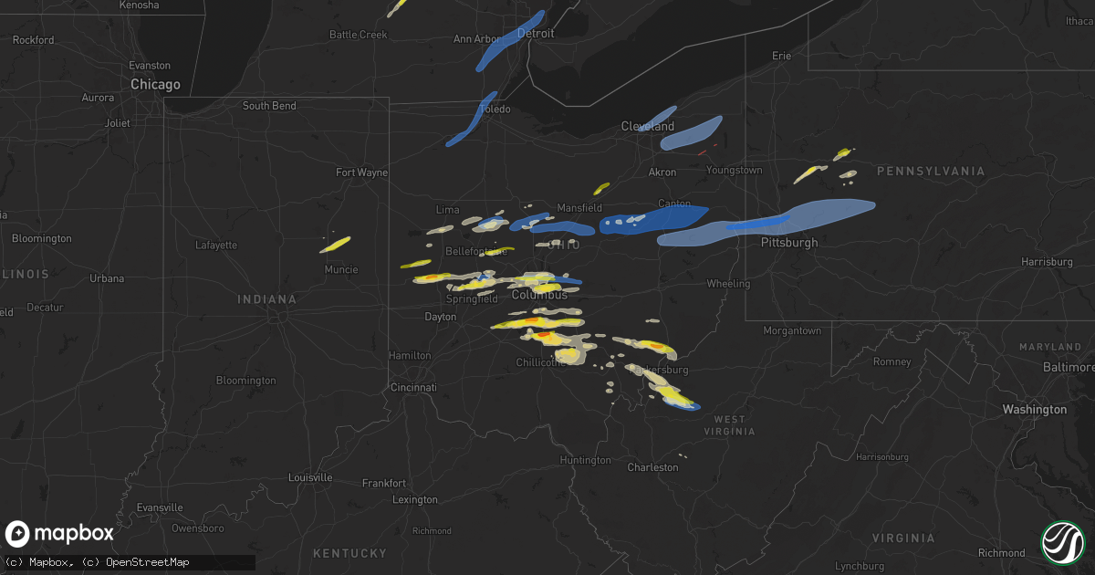
Hail Map on April 17, 2024
Get this storm
April 17 map
$229
one time, instant access
Download today. No call, no setup
Keep the $229
Bought the map and want the full workflow? Apply the entire $229 to a subscription within 7 days. None of it is wasted.
Every map, not just this one
This buys you this map. Subscription and you get every map we run, in the markets you choose from a few cities to whole states to nationwide. Plus real-time alerts the moment a storm fires.
Contact data
Name, contact info, occupancy, even credit band for addresses in the footprint. You go from where it hit to who to call.
Become the source they trust
Unlimited branding weather history reports on demand. You already have the documented answer ready for the property owner, and you are the one who showed up with it.
Property data and RoofTrace estimates
Pull up any address you have got, its value and the exact code rules for that jurisdiction, straight from One Click Code. Then RoofTrace estimates the squares, pitch, and roof value, priced the way you price.
States Impacted by Hail Map on April 17, 2024
Storm reports
Missouri
| Date | Description |
|---|---|
| 04/17/20245:50 AM CDT | Barn largely destroyed near intersection of 208th and raum rd. |
| 04/17/20245:48 AM CDT | Delayed report. Several trees down along hwy pp east of i-35. Time estimated from radar. |
| 04/17/20245:44 AM CDT | Delayed report. Social media photos of several trees down and property damage at a residence south of holt. Time estimated from radar. |
| 04/17/20245:44 AM CDT | Several reports of tree limbs and wires down and minor property damage in the holt area. Time estimated from radar. |
| 04/17/20245:31 AM CDT | Tree limbs and wires down in |
| 04/17/20245:31 AM CDT | Tree limbs and wires down in the town of plattsburg. Time estimated from radar. |
| 04/17/20245:30 AM CDT | Report from mping: 3-inch tree limbs broken; power poles broken. Time estimated from radar. |
| 04/17/20244:00 AM CDT | Corrects previous tstm wnd dmg report from holt. Several reports of tree limbs and wires down and minor property damage in the holt area. Time corrected from social med |
| 04/17/20244:00 AM CDT | Delayed social media report. Several trees down south of excelsior springs... Including one that fell onto and damaged a house. Time estimated from radar. |
| 04/17/20243:59 AM CDT | Downed power lines a |
| 04/17/20243:59 AM CDT | Downed power lines and power outages near cameron road. Time estimated from radar. |
| 04/17/20243:58 AM CDT | Delayed report. Downed billboard on u.s. Highway 69. Time estimated from radar. |
| 04/17/20243:56 AM CDT | Downed tree and wires near central avenue. Time estimated from radar. |
| 04/17/20243:51 AM CDT | Downed trees and limbs reported in kearney. Time estimated from radar. |
| 04/17/20243:45 AM CDT | One-foot diameter tree snapped and a mailbox blown over at residence. Time estimated from radar. |
| 04/17/20243:42 AM CDT | Downed tree limbs and power lines near 70th street. Time estimated from radar and power outage report time. |
| 04/17/20243:23 AM CDT | Report from mping: 3-inch tree limbs broken; power poles broken. Time confirmed from radar. |
| 04/17/20243:18 AM CDT | Downed power lines and power outages near county road ee. Time estimated from radar. |
| 04/17/20243:18 AM CDT | Downed power lines and power outages in the camden point area. Time estimated from radar. |
| 04/17/20243:14 AM CDT | Social media report of powerlines down and power outages in town. |
| 04/17/20243:12 AM CDT | 60 mph winds estimated with power outages reported in town. |
| 04/17/20243:10 AM CDT | Social media report of estimated 60 to 65 mph winds in dearborn. Minor property damage with tree limbs and power lines down in town. Time estimated from radar. |
| 04/17/20243:10 AM CDT | Thunderstorm winds damaged a barn off route 45. Time and location approximated from radar and social media report. |
| 04/17/20243:04 AM CDT | One building damaged with tree into building. Multiple trees down in the town of weston. Time estimated from radar. |
| 04/17/20243:00 AM CDT | Downed power lines and power outages near route 273. Time estimated from radar. |
| 04/17/20243:00 AM CDT | Corrects previous tstm wnd dmg report from rushville. A barn was damaged from severe thunderstorm winds at a residence south of rushville. Time estimated from radar. |
| 04/17/20242:57 AM CDT | A barn was damaged in rushville from severe thunderstorm wind gusts. Time estimated from radar. |
| 04/17/20242:06 AM CDT | Downed power lines and power outages near amie ct. Time estimated from radar and power outage report time. |
| 04/17/20242:00 AM CDT | Downed tree limbs and wires near holly street. Time estimated from radar and power outage reports. |
Pennsylvania
| Date | Description |
|---|---|
| 04/17/20246:58 PM CDT | A few trees are reported down in new kensington with power lines down as well. |
| 04/17/20246:58 PM CDT | Part of school roof blown off |
| 04/17/20246:56 PM CDT | Report of tree into a residential home. Time estimated based on radar. |
| 04/17/20246:56 PM CDT | Tree down on hannahstown road. Picture provided. |
| 04/17/20246:55 PM CDT | Shingles were blown off one roof and the roof of another home was partially blown off along south rebecca sreet. |
| 04/17/20246:54 PM CDT | Report of tree down along 28. Time estimated based on radar. |
| 04/17/20246:53 PM CDT | Report from mping: trees uprooted or snapped; roof blown off. |
| 04/17/20246:53 PM CDT | Tree down on route 28 south between exit 11 and exit 10. One lane closed. |
| 04/17/20246:52 PM CDT | Wires down. Time estimated. |
| 04/17/20246:51 PM CDT | Corrects previous hail report from 2 w parker. Report from mping: half dollar |
| 04/17/20246:50 PM CDT | Large pine tree snapped. Neighbor's trampoline landed on the roof of another neighbor. Time estimated from radar. |
| 04/17/20246:50 PM CDT | Report of tree down on vehicle. Time estimated based on radar. |
| 04/17/20246:49 PM CDT | Report from mping: half dollar |
| 04/17/20246:45 PM CDT | Small tree limbs down less than 2 inches in diameter. |
| 04/17/20246:45 PM CDT | 60 mph winds estimated. Tree blown down onto house. |
| 04/17/20246:40 PM CDT | Multiple telephone poles down on bidwell street. Time estimated from radar. |
| 04/17/20246:38 PM CDT | Report of multiple trees down on 2 residences. Time estimated based on radar. |
| 04/17/20246:38 PM CDT | Trees uprooted on fairfield drive. |
| 04/17/20246:36 PM CDT | At least 16 large... Old trees were uprooted on my property... Almost all of which are within a football field-sized area. |
| 04/17/20246:32 PM CDT | Report of tree down on vehicle trapping people inside. No injuries reported. Time estimated based on radar. |
| 04/17/20246:31 PM CDT | Report and video of large tree down. Time estimated based on radar. |
| 04/17/20246:30 PM CDT | Report of trees down in the area. Time estimated based on radar. |
| 04/17/20246:30 PM CDT | Trees down in cranberry township. |
| 04/17/20246:30 PM CDT | Tree down in yard. |
| 04/17/20246:24 PM CDT | Tree on house. Time estimated. |
| 04/17/20246:20 PM CDT | Tree down on route 65. Time estimated from radar. |
| 04/17/20246:20 PM CDT | Tree limbs and branches down greater than 2 inches in diamter. |
| 04/17/20246:10 PM CDT | Numerous reports of trees and wires down across beaver county. |
| 04/17/20246:07 PM CDT | A few trees snapped on mt. Jackson road. Pictures provided. |
| 04/17/20246:07 PM CDT | Tree down. Picture provided. Time estimated from radar. |
| 04/17/20245:34 PM CDT | A local report indicates 1.00 inch wind near 2 SSE Helen Furnace |
| 04/17/20245:30 PM CDT | A local report indicates 1.00 inch wind near Truittsburg |
| 04/17/20245:29 PM CDT | A local report indicates 1.00 inch wind near 2 NW Strattanville |
| 04/17/20245:24 PM CDT | A local report indicates 1.00 inch wind near 1 NNE Cottage Hill |
| 04/16/20248:07 PM CDT | Tree down on worthington slatelick road. |
| 04/16/20248:01 PM CDT | Tree down on route 66 north of leechburg. |
| 04/16/20247:47 PM CDT | Report from mping: trees uprooted or snapped; roof blown off. |
| 04/16/20247:45 PM CDT | Report from mping: 1-inch tree limbs broken; shingles blown off. |
| 04/16/20247:40 PM CDT | Large trees down... Blocking a roadway. |
| 04/16/20247:36 PM CDT | Report of tree down along state route 18 near waynesburg. Time and location estimated based on radar. |
| 04/16/20247:32 PM CDT | Report of tree and power lines date near sisley town and gillespie hollow roads. Time estimated based on radar. |
| 04/16/20247:21 PM CDT | Trees reproted down along route 21. |
| 04/16/20247:17 PM CDT | Report from mping: trees uprooted or snapped; roof blown off. |
| 04/16/20247:16 PM CDT | Report of tree down in fallowfield township. Time estimated based on radar. |
| 04/16/20247:10 PM CDT | Report of trees down along pa 136 near brownlee road. Time estimated based on radar. |
| 04/16/20247:04 PM CDT | Report from mping: 3-inch tree limbs broken; power poles broken. |
Illinois
| Date | Description |
|---|---|
| 04/17/20245:51 AM CDT | Large metal section of bleachers blown down at gateway motorspark park. Wind speeds estimated to be near 80 mph. Time estimated from radar. |
Michigan
| Date | Description |
|---|---|
| 04/17/20243:50 PM CDT | A large dead tree was reported blown down. |
| 04/17/20243:05 PM CDT | Multiple photos received showing partial roof damage... Damage to building siding... Powerlines snapped... And multiple trees down. Estimated wind speeds of 70 mph. |
| 04/17/20242:59 PM CDT | Large tree limb fell on the road. |
| 04/17/20242:51 PM CDT | Roof damage to a commercial and apartment building. Trees uprooted and tree limbs downed as well. Estimated wind speeds of 65 to 70 mph. |
| 04/17/20242:30 PM CDT | Uprooted trees reported... With estimated wind speeds of 60-65 mph. |
| 04/17/20242:23 PM CDT | A local report indicates 58 MPH wind near Willow Run Airport |
| 04/17/20241:45 PM CDT | Power lines reported down on the road. |
| 04/17/20241:15 PM CDT | A local report indicates 1.00 inch wind near Haslett |
| 04/17/20241:15 PM CDT | A local report indicates 1.00 inch wind near Okemos |
| 04/17/20241:10 PM CDT | Report from mping: quarter |
| 04/17/20241:09 PM CDT | Report from mping: quarter |
| 04/17/202412:59 PM CDT | A local report indicates 1.25 inch wind near 2 NNW Holt |
| 04/17/202412:55 PM CDT | A local report indicates 1.00 inch wind near 2 SW Lansing |
| 04/17/202412:47 PM CDT | A local report indicates 1.00 inch wind near 2 E Dimondale |
| 04/17/202411:54 AM CDT | Tree down across road. |
| 04/17/202411:52 AM CDT | Trees and wires down across the road. |
| 04/17/202411:50 AM CDT | Multiple trees down with a tree hitting a house. |
| 04/17/202411:25 AM CDT | Tree on power line. |
| 04/17/202410:49 AM CDT | Tree down blocking road near 70th street and 80th avenue. |
Indiana
| Date | Description |
|---|---|
| 04/17/202412:18 PM CDT | One downed power pole... Another damaged power pole... And a couple large limbs |
| 04/17/202412:15 PM CDT | Delayed report. Time estimated from radar. Several large tree branches |
| 04/17/202411:55 AM CDT | Ema surveyed damage at a residence in the 6000 block of n sr 1. A large area of shingles was blown off the west facing side of a home and dropped on the northeast side |
| 04/17/202411:47 AM CDT | Several pictures and reports of hail up to at least the size of quarters in and around hartford city. |
| 04/17/20249:48 AM CDT | 1 ft diameter tree limb downed... Appears healthy. Several smaller limbs were downed... And an anchored pool was blown into a fence nearby. |
Ohio
| Date | Description |
|---|---|
| 04/17/20246:55 PM CDT | Delayed report. An employee with the burr oak lodge in morgan county advised there was a tree down along sr-78 near the lodge. Time estimated via radar. |
| 04/17/20246:44 PM CDT | Trees down. Time estimated based on radar. |
| 04/17/20246:42 PM CDT | Report from mping: 1-inch tree limbs broken; shingles blown off. |
| 04/17/20246:25 PM CDT | Tree down. |
| 04/17/20246:15 PM CDT | Delayed report. State garage in morgan county had a large tree down blocking part of sr-669 near the muskingum county line. Time estimated by radar. |
| 04/17/20246:11 PM CDT | Delayed report... Multiple trees down along with large limbs on bristol champion townline rd ne west of n park ave. |
| 04/17/20246:04 PM CDT | Delayed report... Damage to a roof along with several large trees down... One of which was on a garage. A camper was also blown over. |
| 04/17/20246:03 PM CDT | Report and photo of large tree down on titanium way. Time estimated based on radar. |
| 04/17/20246:01 PM CDT | A few trees down on high hill road. |
| 04/17/20246:01 PM CDT | Nws storm damage survey confirmed an ef-0 tornado with estimated peak winds of 80 mph in southington and champion townships in oh. The damage path length is 2.96 miles |
| 04/17/20245:58 PM CDT | A local report indicates 1.50 inch wind near 3 W Stoutsville |
| 04/17/20245:52 PM CDT | A local report indicates 1.00 inch wind near Circleville |
| 04/17/20245:52 PM CDT | A local report indicates 1.00 inch wind near 1 E Lancaster |
| 04/17/20245:51 PM CDT | Trees were reported down on north liberty street near buckeye street in new concord. |
| 04/17/20245:51 PM CDT | Nws storm damage survey confirmed an ef-1 tornado with estimated peak winds of 110 mph in windham... Oh. The damage path length is 3.99 miles and maximum width is 65 ya |
| 04/17/20245:50 PM CDT | A local report indicates 1.00 inch wind near 5 E Williamsport |
| 04/17/20245:48 PM CDT | House damaged on county road 229 south of state route 82. Time estimated via radar. |
| 04/17/20245:47 PM CDT | Drone footage photo shows extensive damage to a house that was shifted off of the foundation. There was also an overturned vehicle. Time estimate via radar. |
| 04/17/20245:46 PM CDT | Tree down on state route 303. |
| 04/17/20245:45 PM CDT | Report of at least one tractor trailer blown over on eastbound lanes of ohio turnpike |
| 04/17/20245:40 PM CDT | A local report indicates 1.00 inch wind near Lancaster |
| 04/17/20245:40 PM CDT | Trees were reported down on route 30 and on 2nd street in hanoverton. |
| 04/17/20245:35 PM CDT | Trees down on state route 9 near pledge road |
| 04/17/20245:29 PM CDT | Tree down. |
| 04/17/20245:25 PM CDT | Tree down on military road. Time estimated from radar. |
| 04/17/20245:25 PM CDT | Tree down on unoccupied cabin on concord drive near leesville lake. Tim estimated from radar. |
| 04/17/20245:19 PM CDT | A local report indicates 1.25 inch wind near Darbyville |
| 04/17/20245:15 PM CDT | A local report indicates 1.00 inch wind near South Bloomfield |
| 04/17/20245:15 PM CDT | A local report indicates 1.00 inch wind near Ashville |
| 04/17/20245:10 PM CDT | One down tree and several large branches. |
| 04/17/20245:08 PM CDT | Large branches down. |
| 04/17/20245:06 PM CDT | Asos station kbkl cleveland. |
| 04/17/20245:05 PM CDT | A local report indicates 1.50 inch wind near 3 W South Bloomfield |
| 04/17/20245:00 PM CDT | A local report indicates 1.00 inch wind near Lithopolis |
| 04/17/20244:50 PM CDT | A local report indicates 1.00 inch wind near 4 E Mount Sterling |
| 04/17/20244:44 PM CDT | A local report indicates 1.00 inch wind near Gahanna |
| 04/17/20244:38 PM CDT | A local report indicates 1.00 inch wind near 2 NW Gahanna |
| 04/17/20244:37 PM CDT | A local report indicates 1.00 inch wind near Gahanna |
| 04/17/20244:37 PM CDT | A local report indicates 1.00 inch wind near 2 NNE Whitehall |
| 04/17/20244:35 PM CDT | A local report indicates 1.00 inch wind near 3 NE Grandview Heights |
| 04/17/20244:35 PM CDT | A local report indicates 1.00 inch wind near 2 NNE Whitehall |
| 04/17/20244:35 PM CDT | Awos station k10g 2 wsw millersburg. |
| 04/17/20244:30 PM CDT | Delayed report of tree downed in killbuck. Time estimated via radar. |
| 04/17/20244:30 PM CDT | Delayed report of tree downed in millersburg. Time estimated via radar. |
| 04/17/20244:30 PM CDT | A local report indicates 1.00 inch wind near 2 S Riverlea |
| 04/17/20244:30 PM CDT | A local report indicates 1.00 inch wind near Johnstown |
| 04/17/20244:29 PM CDT | Damage to several houses on fancher road. |
| 04/17/20244:28 PM CDT | Tree down on tr 91. |
| 04/17/20244:26 PM CDT | Shingles blown off roof. |
| 04/17/20244:26 PM CDT | Ef1 tornado caused tree and structural damage... With maximum winds of 90 mph. Path length of 0.9 miles. |
| 04/17/20244:22 PM CDT | Large tree limbs down. |
| 04/17/20244:22 PM CDT | Tree down near the intersection of sr 754 and cr 320. Time estimated via radar. |
| 04/17/20244:19 PM CDT | Tree down across tr 222. |
| 04/17/20244:18 PM CDT | Tree downed in big prairie. Delayed report. Time estimated via radar. |
| 04/17/20244:18 PM CDT | A local report indicates 1.00 inch wind near westerville |
| 04/17/20244:05 PM CDT | A local report indicates 1.00 inch wind near 3 SE Dublin |
| 04/17/20244:05 PM CDT | A local report indicates 59 MPH wind near 3 W Riverlea |
| 04/17/20243:51 PM CDT | Multiple trees down on route 97 between butler and bellville. One and a half foot in diameter trees snapped about 3 feet above ground. Time estimated via radar. |
| 04/17/20243:51 PM CDT | Multiple trees down on route 97 between butler and bellville. One and a half foot in diameter trees snapped about 3 feet above ground. Time estimated via rad |
| 04/17/20243:21 PM CDT | Ef0 tornado caused tree and structural damage... With maximum winds of 75 mph. Path length of 3.0 miles. |
| 04/17/20243:15 PM CDT | Lasted almost 5 minutes. |
| 04/17/20243:08 PM CDT | Emergency management... Law enforcement... And trained spotters report several instances of structural damage to homes and businesses in bucyrus. Numerous trees down as |
| 04/17/20243:08 PM CDT | Trees snapped a couple of feet above ground in addition to several trees uprooted and structural failure of what appears to be a shed or outbuilding on e mansfield st. |
| 04/17/20243:06 PM CDT | Nws storm damage survey confirmed an ef-1 tornado with estimated peak winds of 110 mph in bucyrus... Oh. The damage path length is 3.48 miles and maximum width is 100 y |
| 04/17/20243:06 PM CDT | Asos station kmnn marion. |
| 04/17/20243:05 PM CDT | Estimated 60-70 mph wind gust and pea size hail. |
| 04/17/20243:01 PM CDT | Tree and utility poles down. |
| 04/17/20243:01 PM CDT | Power lines down near the intersection of university drive and 309. Time estimated via radar. |
| 04/17/20242:50 PM CDT | Delayed report. |
| 04/17/20242:38 PM CDT | Tree down near intersection of cr-144 and township road 199. Time estimated from radar. |
| 04/17/20242:30 PM CDT | A local report indicates 1.00 inch wind near Piqua |
| 04/17/20242:01 PM CDT | Multiple large branches down. Time estimated via radar. |
| 04/17/20241:59 PM CDT | 12-15 inch diameter tree snapped off. Time estimated from radar. |
| 04/17/20241:06 PM CDT | Large tree limbs down. |
| 04/17/20241:05 PM CDT | Semi truck blown over near intersection of oh-15 and cr-i. No injuries reported. |
| 04/17/20241:00 PM CDT | Box truck blown over. Time estimated from radar. |
| 04/17/20241:00 PM CDT | Tree downed halfway across cr 13 off of w high street. No information on size or health of the tree. |
| 04/17/20241:00 PM CDT | Report of severe damage to a home in the 14000 block of county road f. No other information at this time. |
| 04/17/202412:53 PM CDT | Peaked metal roof blown off hog building. Time estimated from radar. |
| 04/16/20247:55 PM CDT | Spotter observed 1 inch hail on property. |
| 04/16/20247:34 PM CDT | Report from mping: quarter |
| 04/16/20247:30 PM CDT | Minor leaf damage due to hail. |
| 04/16/20247:25 PM CDT | Trained spotter reports largest hail size of 1 inch under a severe storm. |
Kansas
| Date | Description |
|---|---|
| 04/17/202411:58 AM CDT | A local report indicates 1.00 inch wind near 1 S Rossville |
| 04/17/20243:39 AM CDT | Downed power lines and power outages near el monte street. Time estimated from radar and power outage report. |
| 04/17/20243:38 AM CDT | 64 mph wind gust and dime sized hail covering the ground. |
| 04/17/20243:32 AM CDT | Downed tree limbs and wires near georgia avenue. Time estimated from radar and power outage report time. |
| 04/17/20243:28 AM CDT | Delayed social media report of quarter size hail in basehor. Time estimated from radar. |
| 04/17/20243:23 AM CDT | Tree reportedly fell onto powerline. Time estimated from radar. |
| 04/17/20243:15 AM CDT | A local report indicates 60 MPH wind near Tonganoxie |
| 04/17/20243:10 AM CDT | Kdot sensor k1lvw. |
| 04/17/20242:57 AM CDT | Multiple reports of wires down and power outages in northeastern leavenworth county. Time estimated from radar. |
| 04/17/20242:56 AM CDT | Property damage reported with the west half of the roof lost. |
| 04/17/20242:50 AM CDT | Roof of house blown off. |
| 04/17/20242:45 AM CDT | Delayed report. Vehicle blown over and damage to a residence in the lancaster area. Time estimated from radar. |
| 04/17/20242:45 AM CDT | A local report indicates 1.00 inch wind near 4 SSE Ozawkie |
| 04/17/20242:36 AM CDT | Downed power lines and power outages near 214th rd. Time estimated from radar. |
| 04/17/20242:35 AM CDT | Social media report of damage to multiple buildings and trees at a farm one mile nw of nortonville near greeley road. Time estimated from radar. |
| 04/17/20242:31 AM CDT | Delayed report. Time estimated from radar. Shop was blown down. |
| 04/17/20242:27 AM CDT | Delayed report. Time estimated from radar. Barn collapsed. |
| 04/17/20242:27 AM CDT | Delayed report. Time estimated from radar. Lost roof on barn. |
| 04/17/20242:25 AM CDT | Multiple trees damaged... Power lines down. |
| 04/17/20242:25 AM CDT | Delayed report. Conifer/cedar tree greater than 6 inches in diameter snapped in half mid-trunk and downed. |
| 04/17/20242:24 AM CDT | Delayed report. Time estimated from radar. Barn blown down. |
| 04/17/20242:24 AM CDT | Delayed report. Time estimated from radar. Barn blown down and damage to a semi truck. |
| 04/17/20242:22 AM CDT | Barn blew down by severe wind gust. Time estimated by radar. |
| 04/17/20242:05 AM CDT | A local report indicates 70 MPH wind near 5 WNW Mayetta |
| 04/17/20241:58 AM CDT | Delayed report... Time estimated from radar. Several large trees down. |
| 04/17/20241:57 AM CDT | Delayed report... Time estimated from radar. Older barn blown over into roadway. |
| 04/17/20241:52 AM CDT | Downed tree limbs and wires near nebraska avenue. Time estimated from radar. |
| 04/17/20241:48 AM CDT | Report from mping: quarter |
| 04/17/20241:46 AM CDT | Numerous trees damaged with a couple large hardwood trunks snaped. Damage to the high school roof too. |
| 04/17/20241:45 AM CDT | Delayed report. Back door smashed in by flying debris... 1500 gallon plastic cisterns completely gone... Power out. |
| 04/17/20241:30 AM CDT | Several large branches down... Playset overturned... Power out. |
| 04/17/202412:16 AM CDT | A local report indicates 1.50 inch wind near 6 SSE Silver Lake |
| 04/17/202412:16 AM CDT | A local report indicates 1.50 inch wind near 7 WSW Topeka |
| 04/17/202412:16 AM CDT | A local report indicates 1.00 inch wind near 7 WNW Pauline |
| 04/17/202412:15 AM CDT | A local report indicates 1.50 inch wind near 6 NE Dover |
| 04/17/202412:15 AM CDT | A local report indicates 1.50 inch wind near 7 SSE Silver Lake |
| 04/17/202412:09 AM CDT | Report from mping: quarter |
| 04/17/202412:08 AM CDT | A local report indicates 1.00 inch wind near 5 NE Dover |
| 04/16/202411:56 PM CDT | A local report indicates 1.00 inch wind near 2 NW Dover |
| 04/16/202411:29 PM CDT | A local report indicates 1.25 inch wind near Clyde |
| 04/16/202411:24 PM CDT | Between mile markers 332 to 333 along i-70. |
| 04/16/202411:00 PM CDT | Power poles down near 110th and vale road. |
| 04/16/202410:42 PM CDT | A local report indicates 1.00 inch wind near Eskridge |
West Virginia
| Date | Description |
|---|---|
| 04/17/20246:06 PM CDT | Hardwood and softwood trees snapped and uprooted. Pictures/video provided. |
| 04/17/20246:06 PM CDT | Trees uprooted on rodgers road. Pictures provided. |
| 04/17/20246:05 PM CDT | Trees down on power lines on allison road. Time estimated from radar. |
| 04/16/20249:20 PM CDT | Also pea to marble sized hail. |
| 04/16/20249:10 PM CDT | Report of tree down at route 50 and route 24 blocking west lane. Time estimated based on radar. |
| 04/16/20249:00 PM CDT | Report of power pole snapped off at top. Time estimated based on radar. |
| 04/16/20248:45 PM CDT | Pole with lines down over us-50. Time estimated from radar. |
| 04/16/20248:42 PM CDT | Report of tree down and downed power line near independence road. Time estimated based on radar. |
| 04/16/20248:35 PM CDT | Report of trees down on power lines. Time estimated based on radar. |
| 04/16/20248:32 PM CDT | Report of tree down on power line along east dale road. Time estimated based on radar. |
| 04/16/20248:32 PM CDT | Report of tree blocking bunner ridger road with nearby power lines down. Time estimated based on radar. |
| 04/16/20248:30 PM CDT | Report of tree donw on powerlines near east dale road. Time estimated based on radar. |
| 04/16/20248:30 PM CDT | Report of tree down on power lines along 4th street. Time estimated based on radar. |
| 04/16/20248:30 PM CDT | Report of tree and power lines down along ranch road. Time estimated based on radar. |
| 04/16/20248:15 PM CDT | Report of a tree down on power lines along seven pines road. Time estimated based on radar. |
| 04/16/20248:00 PM CDT | Report of tree down on route 2. Time estimated based on radar. |
Cities Impacted by Hail Map on April 17, 2024
- Gaston, IN
- Matthews, IN
- Fairmount, IN
- Hartford City, IN
- Upland, IN
- Muncie, IN
- Summitville, IN
- Eaton Rapids, MI
- Charlotte, MI
- Dimondale, MI
- Holt, MI
- Lansing, MI
- Coldwater, OH
- Okemos, MI
- East Lansing, MI
- Mason, MI
- Saint Henry, OH
- Haslett, MI
- New Knoxville, OH
- Saint Marys, OH
- Wapakoneta, OH
- Marion, IN
- Minster, OH
- Anna, OH
- Ansonia, OH
- Versailles, OH
- Waynesfield, OH
- Harrod, OH
- Belle Center, OH
- Russia, OH
- Houston, OH
- Sidney, OH
- Alger, OH
- Kenton, OH
- Bradford, OH
- Covington, OH
- Piqua, OH
- Troy, OH
- Pleasant Hill, OH
- Arcanum, OH
- Greenville, OH
- Fletcher, OH
- Dundee, MI
- Milan, MI
- Maybee, MI
- Willis, MI
- Romulus, MI
- Belleville, MI
- Ypsilanti, MI
- Wayne, MI
- Detroit, MI
- Taylor, MI
- Westland, MI
- Dearborn Heights, MI
- Canton, MI
- Redford, MI
- Inkster, MI
- Garden City, MI
- Dearborn, MI
- Mount Victory, OH
- Ridgeway, OH
- Allen Park, MI
- Forest, OH
- Upper Sandusky, OH
- Rushsylvania, OH
- Conover, OH
- Napoleon, OH
- McClure, OH
- Malinta, OH
- Grelton, OH
- Liberty Center, OH
- Waterville, OH
- Grand Rapids, OH
- Whitehouse, OH
- Monclova, OH
- Maumee, OH
- Toledo, OH
- Holland, OH
- Sylvania, OH
- Lambertville, MI
- Ottawa Lake, MI
- Temperance, MI
- Erie, MI
- Zanesfield, OH
- East Liberty, OH
- West Mansfield, OH
- La Rue, OH
- Bellefontaine, OH
- Hamtramck, MI
- Highland Park, MI
- Casstown, OH
- New Bloomington, OH
- Hazel Park, MI
- Center Line, MI
- Roseville, MI
- Warren, MI
- Eastpointe, MI
- Royal Oak, MI
- Madison Heights, MI
- Ferndale, MI
- Fraser, MI
- Sterling Heights, MI
- Raymond, OH
- Grosse Pointe, MI
- Harper Woods, MI
- Marysville, OH
- Richwood, OH
- Ashland, OH
- Polk, OH
- West Salem, OH
- Urbana, OH
- Saint Paris, OH
- Marion, OH
- Harpster, OH
- Nevada, OH
- Bucyrus, OH
- Morral, OH
- Caledonia, OH
- Galion, OH
- Cable, OH
- Woodstock, OH
- Mechanicsburg, OH
- Springfield, OH
- New Carlisle, OH
- Christiansburg, OH
- Cardington, OH
- Edison, OH
- Mount Gilead, OH
- Mansfield, OH
- Bellville, OH
- Fredericktown, OH
- North Lewisburg, OH
- Tremont City, OH
- North Hampton, OH
- Butler, OH
- Danville, OH
- Howard, OH
- Ashley, OH
- Marengo, OH
- Fulton, OH
- Irwin, OH
- Dublin, OH
- Plain City, OH
- Columbus, OH
- Amlin, OH
- Powell, OH
- Westerville, OH
- New Albany, OH
- London, OH
- Hilliard, OH
- South Vienna, OH
- Galena, OH
- Lewis Center, OH
- Loudonville, OH
- Big Prairie, OH
- Lakeville, OH
- Washington Court House, OH
- Jeffersonville, OH
- Bloomingburg, OH
- Mount Sterling, OH
- Blacklick, OH
- Pataskala, OH
- Johnstown, OH
- Alexandria, OH
- Granville, OH
- Newark, OH
- Shreve, OH
- Millersburg, OH
- Perrysville, OH
- Glenmont, OH
- Fredericksburg, OH
- Holmesville, OH
- Killbuck, OH
- Brinkhaven, OH
- Dundee, OH
- Apple Creek, OH
- Dover, OH
- Beach City, OH
- Wilmot, OH
- Strasburg, OH
- Sugarcreek, OH
- Brewster, OH
- Navarre, OH
- Mount Eaton, OH
- Bolivar, OH
- Zoar, OH
- East Sparta, OH
- Orient, OH
- Williamsport, OH
- Circleville, OH
- Dalton, OH
- Canton, OH
- Ashville, OH
- Somerdale, OH
- Mineral City, OH
- Lohn, TX
- Brady, TX
- Lockbourne, OH
- Reynoldsburg, OH
- Magnolia, OH
- Sandyville, OH
- Massillon, OH
- East Canton, OH
- Dellroy, OH
- Waynesburg, OH
- Canal Winchester, OH
- Carroll, OH
- Groveport, OH
- Lithopolis, OH
- Heath, OH
- Hebron, OH
- Malvern, OH
- Minerva, OH
- Robertsville, OH
- Paris, OH
- Carrollton, OH
- East Rochester, OH
- New Philadelphia, OH
- Stone Creek, OH
- Uhrichsville, OH
- Midvale, OH
- Gnadenhutten, OH
- Dennison, OH
- Sherrodsville, OH
- Scio, OH
- Bowerston, OH
- Leesville, OH
- Kensington, OH
- Millersport, OH
- New Holland, OH
- Baltimore, OH
- Pleasantville, OH
- Lancaster, OH
- Sligo, PA
- Rochelle, TX
- Clarion, PA
- Strattanville, PA
- Jewett, OH
- Amsterdam, OH
- Salineville, OH
- Bergholz, OH
- Mechanicstown, OH
- Windham, OH
- Shippenville, PA
- Amanda, OH
- Clarksburg, OH
- Stoutsville, OH
- Fairmount City, PA
- New Bethlehem, PA
- Mayport, PA
- Cleveland, OH
- Lakewood, OH
- Euclid, OH
- Willoughby, OH
- Wickliffe, OH
- Eastlake, OH
- Mentor, OH
- Southington, OH
- Laurelville, OH
- Rockbridge, OH
- Richmond, OH
- Irondale, OH
- Bloomingdale, OH
- East Springfield, OH
- Hammondsville, OH
- New Cumberland, WV
- Toronto, OH
- Wellsville, OH
- Empire, OH
- Stratton, OH
- Newell, WV
- Warren, OH
- Bedford, OH
- Macedonia, OH
- Solon, OH
- Twinsburg, OH
- Hudson, OH
- Northfield, OH
- Aurora, OH
- Chagrin Falls, OH
- Hiram, OH
- Mantua, OH
- Newbury, OH
- Burton, OH
- Garrettsville, OH
- West Farmington, OH
- Middlefield, OH
- North Bloomfield, OH
- Orwell, OH
- Windsor, OH
- Huntsburg, OH
- Rome, OH
- Rushville, OH
- Sugar Grove, OH
- Bremen, OH
- Georgetown, PA
- Chester, WV
- New Manchester, WV
- Hookstown, PA
- Clinton, PA
- Aliquippa, PA
- Midland, PA
- Industry, PA
- Shippingport, PA
- East Liverpool, OH
- Crescent, PA
- Coraopolis, PA
- Ambridge, PA
- Sewickley, PA
- South Heights, PA
- Leetsdale, PA
- Monaca, PA
- Conway, PA
- Baden, PA
- Pittsburgh, PA
- Wexford, PA
- Freedom, PA
- Warrendale, PA
- Mars, PA
- Cranberry Township, PA
- Bradfordwoods, PA
- Tarlton, OH
- Kingston, OH
- Logan, OH
- Glouster, OH
- New Straitsville, OH
- Chillicothe, OH
- Karns City, PA
- Petrolia, PA
- Gibsonia, PA
- Cheswick, PA
- Allison Park, PA
- Glenshaw, PA
- Butler, PA
- Bakerstown, PA
- Bairdford, PA
- Valencia, PA
- Natrona Heights, PA
- Tarentum, PA
- Freeport, PA
- Sarver, PA
- Leechburg, PA
- Russellton, PA
- Saxonburg, PA
- Cabot, PA
- South Bloomingville, OH
- Parker, PA
- Chesterhill, OH
- Malta, OH
- New Kensington, PA
- Creighton, PA
- Brackenridge, PA
- Indianola, PA
- Hyde Park, PA
- Vandergrift, PA
- Worthington, PA
- Ford City, PA
- Apollo, PA
- Kittanning, PA
- Spring Church, PA
- McGrann, PA
- Ford Cliff, PA
- Manorville, PA
- Shelocta, PA
- Springdale, PA
- Cadogan, PA
- Harwick, PA
- Stockport, OH
- Waterford, OH
- Caldwell, OH
- Creola, OH
- The Plains, OH
- Millfield, OH
- Athens, OH
- Haydenville, OH
- Nelsonville, OH
- Union Furnace, OH
- Fleming, OH
- Lowell, OH
- Elderton, PA
- Creekside, PA
- Rural Valley, PA
- Indiana, PA
- East Vandergrift, PA
- Yatesboro, PA
- Sagamore, PA
- Dayton, PA
- West Sunbury, PA
- Londonderry, OH
- McArthur, OH
- Brackettville, TX
- Vincent, OH
- New Plymouth, OH
- Bruin, PA
- Callensburg, PA
- Amesville, OH
- Marietta, OH
- Smicksburg, PA
- Marion Center, PA
- Home, PA
- Rochester Mills, PA
- Glen Campbell, PA
- Clymer, PA
- Cutler, OH
- Whipple, OH
- Guysville, OH
- Coolville, OH
- Stewart, OH
- Paint Rock, TX
- Eola, TX
- Williamstown, WV
- Reno, OH
- Newport, OH
- Little Hocking, OH
- Washington, WV
- Rockport, WV
- Belleville, WV
- Eden, TX
- Mineral Wells, WV
- Parkersburg, WV
- Millersview, TX
- New Marshfield, OH
- Albany, OH
- Elizabeth, WV
- Ballinger, TX
- Palestine, WV
- Rutland, OH
- Pomeroy, OH
- Talpa, TX
- Walker, WV
- Creston, WV
- Munday, WV
- Big Bend, WV
- Voss, TX
- Coleman, TX
- Valera, TX
- Langsville, OH
- Gaylord, KS
- Ravenswood, WV
- Doole, TX
- Middleport, OH
- Reedy, WV
- Grantsville, WV
- Cheshire, OH
- Mount Zion, WV
- Gouldbusk, TX
- Le Roy, WV
- Spencer, WV
- Arnoldsburg, WV
- Smith Center, KS
- Manhattan, KS
- Junction City, KS
- Lebanon, KS
- Saint George, KS
- Rossville, KS
- Silver Lake, KS
- Alma, KS
- Eskridge, KS
- Wamego, KS
- Maple Hill, KS
- Paxico, KS
- Clendenin, WV
- Bomont, WV
- Agenda, KS
- Cuba, KS
- Topeka, KS
- McFarland, KS
- Belleville, KS
- Harveyville, KS
- Lawrence, KS
- Clyde, KS
- Clifton, KS
- Haddam, KS
- Morrowville, KS
- Linn, KS
- Palmer, KS
- Berryton, KS
- Lecompton, KS
- Washington, KS
- Belvue, KS
- Greenleaf, KS
- Auburn, KS
- Burlingame, KS
- Carbondale, KS
- Barnes, KS
- Wakarusa, KS
- Waterville, KS
- Tecumseh, KS
- Grantville, KS
- Meriden, KS
- Perry, KS
- Saint Marys, KS
- Scranton, KS
- Westmoreland, KS
- Olsburg, KS
- Onaga, KS
- Emmett, KS
- Delia, KS
- Mayetta, KS
- Hoyt, KS
- Denison, KS
- Ozawkie, KS
- Valley Falls, KS
- Oskaloosa, KS
- Atchison, KS
- Nortonville, KS
- Cummings, KS
- Tonganoxie, KS
- McLouth, KS
- Linwood, KS
- Fort Leavenworth, KS
- Easton, KS
- Leavenworth, KS
- Bonner Springs, KS
- Basehor, KS
- Kansas City, KS
- Weston, MO
- Platte City, MO
- Shawnee, KS
- Winchester, KS
- Holton, KS
- Effingham, KS
- Muscotah, KS
- Lancaster, KS
- Saint Joseph, MO
- De Kalb, MO
- Faucett, MO
- Dearborn, MO
- Rushville, MO
- Agency, MO
- Kansas City, MO
- Waldron, MO
- Mission, KS
- Lansing, KS
- Camden Point, MO
- Overland Park, KS
- Farley, MO
- Wathena, KS
- Elwood, KS
- Edgerton, MO
- Smithville, MO
- Riverside, MO
- Prairie Village, KS
- Independence, MO
- Plattsburg, MO
- Trimble, MO
- Easton, MO
- Holt, MO
- Kearney, MO
- Gower, MO
- Lathrop, MO
- Liberty, MO
- Stewartsville, MO
- Troy, KS
- Buckner, MO
- Missouri City, MO
- Sibley, MO
- Orrick, MO
- Blue Springs, MO
- Excelsior Springs, MO
- Levasy, MO
- Camden, MO
- Lawson, MO
- Richmond, MO
- Rayville, MO
- Turney, MO
- Gallatin, MO
- Cameron, MO
- Polo, MO
- Kingston, MO
- Soldier, KS
- Havensville, KS